⇐ Previous part | ⇒
The road to the high-mountainous village was rocky and unimportant; we had to crawl at a snail's pace. I wanted to sleep, but only a professional can fall asleep on such potholes. Niva roared and walked strained, mainly in first gear, the second was no longer enough. Apparently, the left 92nd gasoline, which we poured in Akhty, had an effect. Anton turned on the low. He gazed ahead intently and maneuvered between the scattered stones and bumps, every now and then shifting gears up and down, as if churning butter. It was drizzling rain. Sasha russos reported that the temperature of the oil in the box went up in the Trailblazer. Now both cars switched to lower gears and crawled further along the Caucasian winding serpentine.
We drove into the clouds and it quickly got dark. Visibility dropped to 10 meters, it became noticeably cooler, and the Trailblazer began to cool down. The only navigator who still understood where we were, reported that only 20 kilometers were left to the village. It's about an hour and a half walk. We did not meet a single oncoming car during the entire ascent.
The village was already asleep when two dirty cars, loudly rustling with engine cooling fans, like panting travelers, climbed to the first houses of Kurush - at the same time the highest inhabited locality in the Caucasus and all of Europe, as well as the southernmost inhabited locality of the Russian Federation. The village is located on the border with Azerbaijan on the southeastern slope of Shalbuzdag Mountain, in the valley of the Usukhchayna River at an altitude of about 2600 meters.
1. The village is over 2000 years old, although no one knows exactly when the first inhabitants appeared here. But it is known that the first road to the village appeared in the 60s. Until that time, only their own legs and horses were the main means of transport. Today "down" can be reached by minibus, which runs every two days in winter, and every day in summer. A ticket to Derbent costs 300 rubles. The journey takes three hours.
2. The harsh climate does not allow for farming, despite the fact that the land in these parts is fertile. The maximum that we manage is to collect a small crop of potatoes during the warm summer, and then, only for ourselves, not for sale. Therefore, everyone lives only by animal husbandry and fully supports themselves. Everything goes into business: milk, meat, wool, even dung.
3. On almost every site, like frozen mammoths, there are huge haystacks. Winters are long here ...
Sometimes, in cold winter, the water flowing through the pipes from the Shalbuzdag mountain freezes and then you have to wait until spring. Run with buckets to the spring all winter.
4. Life in mountain villages is a paradise for asthmatics. The purest discharged mountain air with light notes of burnt dung. What could be better?
5. You can wake up in the morning in a fog and see nothing, or vice versa, in sunny weather, admire the kilometer-long wall of Mount Erydag. During the Soviet Union, Kurush was very popular among tourists and climbers. Now there are much fewer newcomers.
6. Due to the fact that livestock are kept in the village, the streets are dirty. It is better not to go out without boots after the rain. In general, everything is like in an ordinary Ryazan village, only with four-thousanders in the background.
7. In the center of the frame, Mount Bazarduzu is the highest mountain in Dagestan and Azerbaijan (4466 meters). The state border runs along its ridge.
Translated from the Turkic Bazarduzu means "market square", more precisely as a specific landmark - "turn to the market, bazaar." The fact is that in antiquity and the Middle Ages in the Shahnabad valley, located to the east of this peak, annual large fairs were held, where traders and buyers from many countries came. From a distance, on the way to the fairs, the main landmark of the "market square", the "turn to the market" - Bazarduzu was striking.
A dialogue from the Middle Ages was presented.
- Excuse me, but how to get to the market?
- Up to the mountain, and to the left.
There were a lot of relatives on the other side of the pass. They are also Lezgins, but they live in Azerbaijan. To go on a visit - the road takes the whole day. Now just so few people go. Only for a big holiday, wedding or funeral. To cross the border you need a passport. And at the very border, you can spend up to 8 hours standing in lines.
8. Talking about life in the mountains, one cannot but tell about food. No wonder they say that the most dangerous thing that can happen in Dagestan is to be fed to death. Oh, this trip was real food terrorism! We have never eaten so much. What are the delicious and always different (depending on the area) Khinkal!
Khinkal should not be confused with Georgian khinkali, which is a significantly different type of dish. Digastan khinkal is a piece of dough cooked in meat broth (actually "khinkalins"), served with broth, boiled meat and sauce.
9. And this is Miracle, a dish for a large solemn feast, also a national dish of the peoples of Dagestan. This is a kind of thin pie made from unleavened dough with a variety of fillings. The dough is rolled out as thin as possible. The main taste is created by the filling, it can be meat, potato, with cheese and herbs, or just vegetable. After baking, the miracle is necessarily oiled with oil, so they become more aromatic and tender.
10. And this is a school "cake". In one of the mountain villages, we went to a local school, where they prepare their own bread for the children in the canteen. Do not take him out of town every day.
13. In many mountain villages there is no concept of streets, alleys or driveways. Moreover, there are no avenues and highways. Sometimes even houses do not have their own numbers. The postman and the district police officer know all residents by their first and last names.
14. “Our ancestors climbed so high that no one would touch them. The Dagestan mountains are harsh. Not everyone will go to them. So they got away from endless wars and devastation. " - says Bashirov Tagi Aslanovich, head of the village of Kurush.
18. Sometimes a neighboring village speaks its own language and communication with neighbors takes place only in Russian. As the universal English language in Europe, so is the Russian language in Dagestan.
21. Dung cakes on the wall of the house. This is both fuel and insulation at the same time.
27. Young girls are afraid of photographers like fire.
28. Guys, on the contrary, pose with pleasure.
29. Class of mathematics.
31. Director of the school.
“Almost all young people are leaving. Many go to Derbent and Makhachkala, who go to Russia. Many are sent to serve on a contract basis, it is profitable. Young people are simply bored here. "
33. A series of photographs "Sasha is coming".
36. It's almost like Tibet, but only Russia. And they speak Russian here.
Half of the entire area of the Republic of Dagestan is occupied by mountains. Very different mountains: high mountains covered with alpine meadows, and icy peaks of the south of the republic, and Inner Dagestan, with its gorges and sharp rocks. The average height of the mountains of Dagestan is 960 m, but on its territory there are about 30 peaks with an altitude of more than 4000 m.
The south and west of Dagestan are occupied by the Dividing Range of the Greater Caucasus. It is these mountain ranges that shape the weather in the republic: they trap humid air currents from the south, therefore, the climate in Dagestan is predominantly dry.
Dagestan mountains
Bazarduzu
Bazarduzu is the largest mountain in Dagestan. Its height is 4,466 m. Bazarduzu is the top of the Dividing Range and is located on the very border of Russia and Azerbaijan. From this mountain, the relief of the ridge in the eastern direction decreases, therefore Bazarduzu is the highest point of Azerbaijan and the so-called "pole of cold" of this state.
The mountain glaciers represent the easternmost group of glaciers in the entire Main Caucasus. On the northern slope of Bazarduzu there are two glaciers - Tihitsar and Murkar. Five small tongues descend from them. Easier to get to Tihitsara. Its length is a little less than a kilometer, width is 150-200 m. The peculiarity of Tihitsara is its huge slope - the difference in altitude is 250 m, so the glacier is rapidly moving down - up to 9 cm per day.
The Murkar glacier stretches to the northeast. It is much larger than its neighbor: the length of Murkar is about 1400 m, the width is 300–450 m. The glaciers of Mount Bazarduzu are rapidly decreasing. In 1897, their area was 13.8 square meters. km, now it is almost four times less - only about 3.8 sq. km.
Many rivers are born on Mount Bazarduzu. The tributaries of the Samur River originate here. The mountain slopes are covered with picturesque alpine and subalpine meadows. The flora and fauna are diverse and amazing: there are a lot of tours, chamois and roe deer. High up on glaciers and on hard-to-reach cliffs, mountain turkeys and snowcocks live.
Diklosmta
The mountain range lying on the border of Dagestan, Chechnya and Georgia, in the eastern part of the Greater Caucasus, Diklosmta is included in the ridge of the Snow Range and has several high peaks covered with eternal snow:
- Central Diklosmta (4,285 m) - the highest mountain in the massif;
- Eastern Diklosmta (4275 m);
- Western Diklosmta.
The array is visible from afar. Several large glaciers lie on Diklosmt. The total area of nine permanent and the most significant of them is more than 5 square meters. km. These glaciers give life to the rivers Khulandoy, Chero, Gakko.
Shalbuzdag
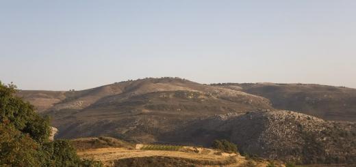
One of the peaks of the southeastern part of the Main Caucasian ridge - Shalbuzdag - is located so that it seems as if it is the highest mountain in the south of Dagestan, its height is 4 142 m. In fact, the peaks surrounding Shalbuzdag are much higher. The uniqueness of the mountain is explained by the many legends associated with it.
Shalbuzdag is a sacred mountain for Muslims. Every day in the summer months, hundreds of pilgrims climb to its summit. There is a belief that many centuries ago a saint, a descendant of the Prophet Muhammad, Sheikh al-Burzi lived on Shalbuzdag. He reconciled the warring nations. It is believed that the sheikh lived on the mountain, died and was buried there.
But there is another grave at the top of Shalbuzdag, it is located in the sanctuary "Pir Suleiman". There is a legend that a very pious and pious man, Suleiman, lived at the foot of the mountain. When he felt that it was time for him to leave this world, he said goodbye to his fellow villagers, lay down on a stretcher and died. A flock of pigeons descended from the mountains, picked up a stretcher and carried them to Shalbuzdag. Suleiman was buried there. Now a small crypt has been erected on the site of his grave; the grave itself is enclosed in marble. Everything in the crypt is arranged for prayer.
There are also two mosques in the vicinity of Shalbuzdag. By the way, on one of the slopes of the mountain there is the highest mountain village in Europe - the aul Kurush, it rises above sea level at 2560 m.
Pushkin-tau
In the vicinity of the town of Izberbash there is a small, but very famous mountain. It is called Izberg-tau, but the people are better known as Mount Pushkin. The fact is that at a height of 150 m, the outlines of the rocks are superimposed on each other in such a way that, at a certain angle of view, the poet's profile looks upward. The best view is from the Rostov - Derbent highway. Pushkin-Tau is loved by locals, tourists, as well as paragliders.
In this article I bring to your attention a story about our trip to the Dokuzparinsky district.
The next point on our route was the Dokuzparinsky district. Having previously discussed all our actions, we left for Usukhchay, where Rakhman Gereev, a representative of FLNKA in the Dokuzparinsky district, was already waiting for us.
As the main goal, we chose a visit to the highest mountain village in Europe - Kurush. Rahman provided us with transport in advance.
Dokuzparinsky district is the smallest Lezghin district of Dagestan in terms of area and population. It is located in the extreme south of the republic, it is here that the southernmost point of Russia is located - an unnamed peak near Mount Ragdan.
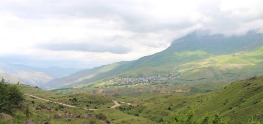
View of the villages of Tekipirkhur and Kalajukh
The name Dokuzpara comes from the Türkic word "doqquz" - nine. It was this number of villages that were part of the historical Dokuzparinsky free society, located, however, on the territory of the neighboring Akhtynsky district.
And on the territory of the present Dokuzparinsky district there was historically the Altyparinsky free society.
Almost all the villages of Dokuzpary are located in the narrow valley of the ChIekhivatsI River. This gorge is bordered by the massifs of the Shalbuzsuv, Glavny Kavkazskiy, Samurskiy ridges, as well as the spurs of the Erysuv mountains, separating the UsukhvatsIa gorge from the neighboring Adjiakhur gorge, which already belongs to the neighboring Kusar region.
Kalajuh
In general, the area itself is notable for its extraordinary relief characteristics. The main part of the territory of the region is represented by a deep gorge, and mountain ranges and peaks rise along the perimeter of the gorge.
Among them is the highest point of Dagestan - Mount Kichensuv (Bazarduzu) 4466 m, just to the southeast is Mount Ragdan. These and other peaks belong to the Main Caucasian Range.
 Charaur waterfall falling from Erysuv
Mount Shalbuzsuv is the second highest in the region and the third in the republic, its peak is at a height of 4142 m. Massive spurs made of clay shales and lime rocks extend from the mountain in all directions.
In the southeastern part of the region, there is the mountaineering center of Russia - Mount Erysuv with a height of 3925 m. Every year the most inveterate fans of extreme recreation ascend this mountain. From the north, in front of the villages of the Dokuzparinsky region, the Gestinkil peak rises with a height of 2788 m.
The first settlement that we meet at the entrance to Dokuzparu is Karakyure. Nowadays, there are two villages - a new and an old aul, located a few kilometers from each other.
 View of Kurush, Shalbuzsuv and surrounding ridges from Mount Erysuv
According to some reports, already in the III millennium BC, in the Bronze Age, the surroundings of Karakyure were inhabited by people. This is evidenced by the huge areas of cemeteries that surround the aul from all sides.
In the center is the highest peak of Dagestan - Mount Kichensuv (Bazarduzu), on the left is Erysuv
According to historians, Karakyure was formed by the merger of several settlements - Yar-k'il, ChIuru khuir, Usukh, Chieyar, Sutar avai khuir and Uruk. The latter, by the way, was the residence of the Albanian kings. Tukhum Varazar lives in the village today, whose name comes from the name of the Albanian king Varaz, who loved to rest in Uruk.
 Old mosque in Karakyur
The remains of an ancient ceramic water supply system were found in the aul. Karakure is a kind of open-air museum. Everything here speaks of its antiquity and greatness. Indeed, in the Middle Ages there was a large city, an important center of Southern Dagestan.

Erysuv
It had at least 900 households. Considering that4-5 families lived under one roof at once, it becomes obvious that this was a really densely populated city. After a terrible plague epidemic in 1689, only 60 households remained in Karakyur. Nowadays, more than 1200 people live in the village.
On the site of an ancient Christian temple in the 10th century, the Arabs built a mosque, which was known throughout southern Dagestan.
 Carved door of the old Karakyurin mosque
Unfortunately, in the winter of 2009, this unique mosque burned down. A few weeks ago, a new mosque was built by Suleiman Kerimov, a native of this village.
 Old mosque in Karakyur
The regional center of the Dokuzparinsky district is the village of Usukhvats I, located at the confluence of the Usukhvats I river of the same name into Samur. Historical chronicles testify to the events of the early 8th century that took place in this village.
Clouds envelop the Upper Dokuzparu
There are two versions of the origin of the name of the aul. According to the first, the root "usuh" acts as a form of the verb "sukhun" (stick, stick). The fact is that the Usukhvats I river during heavy rains sticks into Samur like a bayonet.
The second version brings us back to the events that took place many centuries ago, when the Mikrakhs expelled the sons of Mukhtar Saidjab, considering their lands their own. As a result, these territories seemed to be stuck between Miskindzha and Karakyure, hence the root "dry".
The first inhabitants of the modern aul were people from the neighboring village of Karakyure. Nowadays, the population of the district center is about 2 thousand people.
From here we drove up the gorge. With each kilometer, the level of altitude became more and more. The road went along the UsukhvatsI river. Huge rocks and rocks were visible everywhere.

Kalajuh
The main occupation of the inhabitants of Dokuzpara is animal husbandry and agriculture. Sheep breeding is especially developed in the region. Large areas are occupied by cabbage, sometimes even entire slopes are planted with it. Immediately after Mikrakh-Kazmayar, the first solid ascent began.
Kalajukh, an aul, immediately opened up to our eyes, a gorgeous view of which we observed all the way to Kurush. Kalajukh is located on the opposite bank from Mikrakh. The old village was located on the top of the Aga-ah mountain.
The name of the village comes from the word "Kala" - a fortress. Indeed, the old village was surrounded by powerful walls. The Kaladzhukhs always had a dispute with the Mikrakhs over land, as a result of which the village was taken by neighbors. Many residents died, there were also fugitives - villages with the same name Kala in Azerbaijan and Rutul were founded by fugitives from Kalajukh.
Feast in the village of Tekipirkhur
The modern village is a continuation of the old one, only located in the lower reaches of the historical aul. The inhabitants of the village are the descendants of Menzifar tukhum - the only tukhum who did not leave his native land; as well as numerous settlers from Mikrakh and other villages.
Having passed Mikrakh, after a few kilometers we entered the village of Tekipirkhur.
This is a small aul, which was founded about 500 years ago by a native of Syria, Pir-Hasan, who, together with his brother Pir-Suleiman, was buried on Mount Shalbuzsuv. There is a mausoleum of Pir-Hasan in the aul, and there is also a ziyarat in the cemetery.

His grave is a place of pilgrimage for thousands of Muslims. Tekipirkhyur is a small village, the number of yards in it barely reaches 60. It is located in a picturesque place at the foot of the Erysuv and Shalbuzsuv mountains. This is the native village of Suleiman Kerimov's mother.
 In Kurush
Further, behind Tekipirkhur, Kurush was already waiting for us. It should be noted that we were very unlucky with the weather in it. If in UsukhvatsIe there was clear hot weather, then after Mikrakh-Kazmayar it became cloudy, in some places it rained, which made it impossible to see the amazing views of the surrounding mountains.
Kurush
After a dozen kilometers of narrow serpentines, long climbs and steep cliffs, we finally reached Kurush, the highest mountain village in Europe and Russia. By God, this is a unique place. People here are unique. The nature is unique. Air, plants, animals, birds - everything is unique.
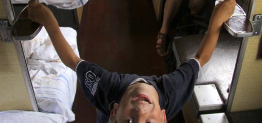
Kurush children
 Kurush in clear weather in summer against the background of Erysuv
Kurush is surrounded by the highest mountains of Dagestan - from the east Kichensuv and Erysuv, from the north - Shalbuzsuv, from the south - the Main Caucasian ridge. The village is located on the southern slope of Shalbuzsuv, at an altitude of 2600 meters above sea level.
 Children playing soccer in the Kurusha schoolyard
Probably the best views of the mountains in all of Southern Dagestan open from the height of the village. From the east of the aul, Yarusuv rises majestically. From this mountain falls the highest waterfall in Dagestan - Charaur. The height of the fall is 250 meters, and the waterfall is two-stage - the height of the first step is 150 meters, the second is 100 meters. Kurushtsy call it Charadur.
The air in Kurush is rarefied, through which the ultraviolet rays of the sun burn all year round. Due to the lack of oxygen, the faces of the Kurush people acquired a characteristic blush, which distinguishes them from other local residents.
 Kurush
Since ancient times, the main occupation of the inhabitants was sheep breeding, extensive alpine pastures - the only wealth of the Kurush people - contributed to this. Sheep breeders led a semi-nomadic lifestyle. Earlier, for the winter period, they drove flocks of sheep to Azerbaijan, overcoming hundreds of kilometers of roads through gorges, passes and ravines.
There are statistical data, according to which in 1917 there were 72 thousand sheep in the village. It was in Kurush in natural conditions that the mountain Lezghin coarse-wooled breed of sheep was bred, the coarse wool of which is indispensable in carpet weaving.
Kurush greeted us with a gray haze. As I said, because of the fog and rain, alas, we practically did not see anything. At a distance of over 20-30 meters, it was no longer possible to make out anything. It is also worth mentioning the characteristic smell of dung, which is almost the main building material and fuel here. There were practically no people on the street. Only the restless kids played football in the schoolyard.
After walking a little around the village, we, however, did not go much deeper. We took a few frames and moved in the opposite direction.
On this day, we decided to stay overnight at Rahman's house, in Mikrah. It is a rather large village located on the left bank of the Usukhvats I opposite Kaladzhukh. This region is rich in arable land, hay meadows and extensive pastures. There are many springs and streams here.
 Mikrakh
On four sides the village is surrounded by majestic mountains - Kichensuv; Erysuv; Nisinsuv (Midday Mountain); Ekunsuv (Morning Mountain); Shalbuzsuv and Gestinkil.
We took a short walk around the village. Rakhman works as a teacher in a rural school, so he knows the history of his native village well.
According to folk etymology, the name "Mikrah" comes from the words "mug" and "rag" (the nest of the sun). The fact is that when the sun rises from behind the mountains on the eastern side, it hits its rays directly into the aul, i.e. as if into a niche, into a nest. Hence "mugrag >> mikrah".
Mikrakh is one of the largest carpet-making centers in Dagestan, Mikrakh carpets are distinguished by the quality and uniqueness of the pattern, local carpet-makers stand out for their art of quick work.
 Tekipirkhur
This is a very ancient village. In 1994, local residents celebrated the 5000th anniversary of the village. However, the figure is, of course, overstated. The first mentions of Mikrah date back to the 2nd century AD. Numerous cemeteries with an area of more than 20 hectares also testify to the antiquity of the village.
Ancient burial places of Mikrakh
In the Middle Ages, Mikrach was a city that was a handicraft, trade and cultural center of the region. During the early Middle Ages, for many years Mikrakh was a stronghold of the Khazars and the city did not accept Islam, offering fierce resistance to the Arabs. However, the combined forces of Arabs and Akhtyns took the village by force.

In a later period, the aul fully recovered, expanded and regained its former value. In 1630 it became the administrative center of the newly formed society Altypara. In the 19th century Mikrakh was the administrative center of the Dokuzparinsky naibstvo of the Samur district.
Rahman showed us the local ziyarat. As well as numerous Christian graves that can be seen everywhere. Almost every stone or slab speaks about the antiquity of the village.

The modern village looks rather poor and faded. There are many dilapidated houses in which people still live. There is no normal road, poor communication. From Mikrakh, Kaladzhukh is clearly visible, which is just a stone's throw from there. At night, there was a dem (wedding dance evening) in Kalajukh, the music was heard as if the wedding was being played in Mikrah.
Mikrakh
Rahman's house is located in the upper part of the village, from its veranda offers a stunning view of Nesinsuv and Kichensuv. Rahman's grandmother made us feel welcome. Our evening was spent talking and discussing what we saw.


FLNCA
Shalbuzdag is the main natural attraction of Dagestan. Its distinctive feature, in comparison with others, is that this mountain, as it were, stands alone, rising up as a lonely pyramid topped with a jagged top. Due to this location, Shalbuzdag gives the impression of the highest peak in the southern part of Dagestan, although the neighboring ones - Bazarduzu and Shahdag - are actually higher. But these are not all the features of a mysterious natural phenomenon. Shalbuzdag. The most famous mountain in Dagestan. Every year from July to August, pilgrims come here from all over the Caucasus. - If you ask, then everything will be fulfilled, it only takes time. The mountain is closer to Allah, he hears our prayers. The mountain became sacred after the grave of the righteous Suleiman appeared there. According to legend, he was very God-fearing, and when he died, a miracle happened. Since then, pilgrims have come here every year. They bring alms and ask God for health for loved ones. It is believed that in order for prayers to be heard, it is necessary to go around the feast three times and be sure to tie a ribbon or scarf. Scientists believe that there used to be a sea on the site of the mountain. Unlike all other heights, Shalbuzdag is distinguished by its unusual shape - a pyramid with a jagged top. This gives the grief a special mystery. Mountain Shalbuzdag is popularly called the road to the fulfillment of desires. The height of the mountain is 4 thousand 150 meters. People believe that if you overcome this distance, then all your dreams and desires will certainly come true. The higher people climb, the steeper the climb itself becomes. The narrow path is strewn with small pebbles, because of them the feet constantly slip. Choking from lack of oxygen, travelers go up, stopping for a breather almost every 20 meters. It is quite normal to meet more than one pair of worn-out sneakers or slippers on the way here. On the mountain, even the most comfortable shoes cannot withstand the load. But, despite the difficulties and armed with a stick, people go to their goal. However, good travelers help someone. A stone path leads to a small lake. It is located in the middle of two rocks, where the sun's rays hardly fall. The water here is clear and cold, even in summer it is covered with thin ice. The source is considered sacred, and the water in it is medicinal. From the lake to the top, there is the last spurt - one kilometer. Here another test awaits a person - a narrow passage among two rocks. In order to get out of it, you need to climb the stones, which seem to be varnished. According to legend, a sinful person, even the skinny one, gets stuck in this passage. Well, those to whom God has forgiven their sins pass easily.
What amazes and delights any person who comes to Dagestan? Of course, mountain ranges. The mountains of Dagestan are perhaps its main attraction. At the same time, guests from the central part of Russia often do not even ask the question of how one peak differs from another. But for the Dagestanis themselves, many mountains have their own history and names.
Geographic and climatic features
Almost half of the entire Dagestan territory is occupied by mountains. They surround the republic from the southeast and northwest, but at the same time they are considered foothills. The alpine part is the central territory. Few people know that there are 30 highest mountain peaks on the territory of the republic - peaks with a height of more than 4,000 meters. The largest of them is Bazarduzu, it (together with the ridge) is the border with Russia and the southernmost point of the country. In general, the area occupied by the mountains reaches 25.5 thousand square meters. kilometers.
Despite the abundance of mountains, the republic has a rather dry climate. It belongs to the temperate continental. This is because the Dividing Range does not allow humid air currents from the south. In part, this also contributes to the brightness of the famous Dagestan alpine meadows - the so-called flat areas on the mountain slopes adjacent to forests.
Finally, Mount Sarykum is of great interest to researchers. Its height is small - only 351 meters. But Sarykum attracts scientists by the fact that it is, in fact, the dune - the largest in Eurasia. The sandy mountain is constantly "dancing", changing its shape under the pressure of the winds, but it does not crumble.

Alpine glaciers and climbing routes
Not only peaks and ridges are the hallmark of the region. Speaking about the Dagestan mountains, one cannot ignore the glaciers. There are many of them here, but they do not make up some kind of integral massif and are distributed along the peaks and ridges. The largest glacier is observed on the Bogos ridge, here the glacier area reaches more than 16 km2. At the same time, some glaciers descend quite low - for example, Belengi (2520 meters). Here are the most famous places of glaciation:
- Bogossky massif. It is the largest glacier in the eastern part, and in addition, the largest in length - over 3 km.
- Butnushuer - Korkagel. The glacier area is 2.2 square meters. km, and it is clearly insufficiently studied by specialists.
- Bishinei-Saladag. It occupies the second largest area after the Bogos glaciation and includes 27 glaciers. The area is about 10 sq km.
- Snow ridge. This glaciation is the northernmost in the republic, its area is 7.72 sq. Km.
- Dyultydag. On this ridge, glaciation is located along the northern slopes. Glaciers are not represented here by vast areas, but their boundaries are well explored.
It should be borne in mind that, despite the fact that the mountainous area as a whole is well studied by both geologists and historians, there are still many discoveries ahead of researchers. In the meantime, the beautiful mountains of Dagestan continue to attract tourists and climbers. Quite a lot of tourist routes have been laid here, and they are replenished due to the tourist business.
Today you can go, for example, along the Main Caucasian ridge along the catchment area of the Sulak River (the route takes about 46 km). Another interesting option is along the Snow Ridge through the plateau of the Celestial Falling Asleep Lakes to the same Sulak. The passage of Oritskali Dagestanskoe Gorge - Moshota is also of great interest among tourists. Finally, there is always the opportunity to walk along the Bogos ridge line along the watershed of the Avar and Andean Koisu rivers.
These are not all possible routes. The region is as diverse as it is. Tourists are always welcome in the villages, where residents have long been famous for their generosity and hospitality. to personally see its nature and people who live here and can tell a lot about their native mountains.