Mount Shiy is higher point The Georgian Ridge, its height above sea level is 542 m. The peak is located in the north-west direction, approximately 5.5 km from Art. Erivanian. The top is rather common, stretched from the east to the west. The southern part, the vertices are located in the direction of the Ambin River, the slopes are quite cool, places of cliffs that have characteristic powerful rocky outcrops with a length of about 1.5 km, their height is 80-100 m.

The picturesque panorama on the top opens from the Erivanian. At the time of the Second World War, this area was a venue of fierce fighting. Here the defense line Novorossiyskaya stretched along the northern slopes of XP. Georgian. The top was the most important strategic bridgehead and constantly passed from the Germans to our troops and on the contrary. The fascists had special parts of the third division of the mountain arrow, defeated 26.09.1942. These events read Obelisk, which is installed on top of Schia.
On the top of the mountains grow wild pear, apple tree, dogwood, hawthorn, rosehip. Juniper grows on rocky outcrops. In the end of the spring - the beginning of the summer blooms ash Caucasian, at the contact of which biological burns appear on the skin. This plant is dangerous only during flowering. On the jumper between XP. Georgian and Vasikov XP. There is a spring. By xp Georgian is a good trail, in the summer, the trail turns into the road along which jeeps drive.
The title of the vertex has Adygean roots "Shy" - one, "Shl" - horse. The title of the vertices can be translated as a "lone horse".
Route Stanitsa Erivanian - Mount Schiy (542 m) - Erivanian village.
The length is 7 km, the running time is 1.5 hours.
To art. Erivanskaya can be reached or on a flight bus next to Abinsk, or by car through with. Svetlogorsk To x. Erivans goes an asphalt road, further gravel, driving on a passenger car without difficulty in any season of the year
Approximately 2 km to Art. Erivan, you need to go out on the Erivan pass. It is also possible to go out in Erivan, but at the same time our route will be a kilometer for two longer. From the final stop in the village you need to go in the opposite direction, towards the city of Abinsk, to the top of the Erivan pass. You can also go down the street over the bridge to the north and in the dirt road from the village to move to the deposit shoulder, through which the trail goes. From the pass on a translated shoulder in the western direction there is a trail to the top of the sewage. The trail first goes on a relatively flat terrain of about 10 minutes, then it begins good, in some places a very cool rise. There are rock-and-oartled areas, their overcoming of special work will not be. After a steep fission, approximately 50 minutes, the trail displays the sewer to the top. You need to return to the same route.
In the morning it rained rain, then the fog appeared, on top there were clouds and saw the Erivanian village from the height, then the wet snow went, but the weather was already cleared up and the sun turned out. Here is the weather in the mountains, very unpredictable.
Mount Shize is translated from Adygei as a "lone horse".
In the warm season from the mountain paragliders fly. There are legends that the mountain Shiy has the medical force. Each man breathaning the air of mountain colors, becomes young and strong.
The campaign can be called children's, absolutely not difficult if the ascent is to do in the warm season. From the village of Erivanian to Mount Schiy - just 5 km (1.5- 2 hours in one direction). From Erivanian through Schiy and Ridge Georgian, you can go to the village of Shapsuga, it is here near. On the way they met Spring.
2. We started from the village of Erivanic (Abinsky district) - it is 100 km from Krasnodar. Fog in the mountains was might and main, but there was little snow.
3. The higher the raised, the more snow and humidity, shoes in all wet. Conclusion: Only rubber boots should be worn in such weather. 
4. Despite the snow, we rose 1.5 hours before the top of the sewage. 
5. Fields. 
6.
7. View of the village of Erivanian. Not having to admire the view, it rained, and then wet snow. 
8. Just climb the mountain Schiw and go down to us too much, we decided to go to the Georgian ridge. 
9.
10. The Georgian ridge looks like. One of the tourists saw a root in these places. 
11. In order not to go back the path, they decided to make a circle and along the way to climb the mountain of Rotina. Rolled with a well-holted road into the bushes (this showed the track on the navigator). And now I accidentally found a grenade RGD-33. Most likely, she was here at the time of the Second World War. It is a fragmentary offensive-defensive. During the war years, fierce battles went here, because it was an important segment of the front aimed at the defense of Novorossiysk. The line of defense took place along the northern slope of the Georgian Range. The vertex is the most important strategic bridgehead - it passed into one, then in other hands. The Germans had specially trained parts of the Mining and Rifle Division, which in September 1942 were defeated. 
12.
13. Go away from the Georgian Ridge, we go to the trails of boars. 
14. Some people from the group are tired, and we decided not to rise to Mount Rotina. Go down to the Ambin River, and here a good highway goes along the river, and here such species. 
15. It remains 5 km from the village. 
16. Met a few horses. 
17.
18. Going almost to the Erivanian village, our track showed that it was necessary to move the Ambin River River, but the river spilled in December, most likely she would be on the belt. But near was the spare option - the road again went along the river.
It's time to write a little about one of my favorite routes in the Abinsky district. We are talking about a linear route to Mount Schiwa with descent on the Georgian ridge.
Route to Mount Xiza is suitable for tourists of any training, in my practice this mountain was taken by both women of a pensioner 50-60 years old and small children from 6 years.
The best linear option for the conquest of Mount Schiz begins from the Erivanian village and ends 3 kilometers from the village of Shapsuga. The length of the route in this case is about 15 km, and occupies an average of 6-8 hours.
Such a route is available for groups of non-own transport groups, as it will be quite difficult to return to Erivskaya for the machine.
Route №1 (Erivanskaya - Mount Schiy - XP. Georgian - Shapsugskaya) ~ 13 km
The presented track marked the path to another sewing vertex, but it is not obligatory to visit. Further description corresponds to this particular track.
Route №2 (Erivanian Pass - Shiy Mountain - Erivansky Pass) ~ 6 km
This Schiw route does not require a start in Erivanian, for example in winter, and start with the Erivan pass, then the path to the top will be slightly simpler and shorter, it is the most speedy and weather method.
Route №3 (Erivanskaya - Shiy Mount - Ryutila Mount-Erivanskaya) ~ 20km
Another fresh track of a circular walk to Mount Schia, from the last exit in early May 2014. A circular track captures the walking on the meadows of the Georgian ridge and the descent on a good road to the Valley of the Ambin River.
The route begins with one of the Erivanian Lullets, the road passing between the plots rests on the forest, where the steep winding path begins through the stream. To the right, without turning the stream old road, on it, too, you can start the rise and soon these roads will come up. Moving along the path or the road there is no complex forklog, the road is somewhat longer and the position is gaining height. On any fork, when lifting the mountain Shiy, it is worth choosing more on the trash and / or outgoing path.
When lifting it will be a gentle plot, it is Polyana Kurganov, ancient grave age for more than 5000 years. Only a small part of them is looted, which suggests that the local tribes lived is not rich (finding details about the Kurgan and about the peoples of living here)
After a walk through an ancient position, the main fork of roads, from the bottom where the road goes to the Erivanian pass (we meet the route of the route number 2), and sharply up to the top of the mountain of Schiism. This is the final breakdown on the way to the top, 100 meters from the intersection, barely a noticeable trail goes left to the left, even steely gaining a height, it is the shortest path. You can use a cut or continue on the road, it will lead to a small saddle 400 meters from the top of the mountain.
Rest in front of the final lifting section

Start lifting on the trail cut

A rare schoolboy will run away on the top without stopping on this path
Thinking to the top in just two hours, it is convenient to lie down on a steep slope and enjoy the wonderful views of the surroundings. Despite the obvious things, tourists often ask that the village is located at the bottom, this is the Erivanian village from which he began to rise to Shiy. They can be understood from such a height and beauty, especially in clear weather, the spirit captures for a long time.

Panorama of Mount Schia, towards the Erivan

Houses in the village from the top of Schia

Tag on observation sew
The eye of an experienced tourist in the mountain panorama immediately recognizes the ridge and the top of the mountain Thab, the left rocky protrusions of the mountain papay, to the left of the Mountain of the Camera-Bash and under the core of the Bear Mountain. To the right of the Thab mountain, the less famous peaks of Botzechur, Chubate, bald and lead, the most famous of this list.

Resting on top, we continue the path to the trail passing the traverse on a steep slope. After some time we get on the second looking platform And remember interesting factthat we just were not at the top of the Schiy Mountain, but on the nameless 541.0. On the Internet you can meet an active discussion and a study on the true arrangement of the top of the sewage, from which there is no reasonable opinion except the vertices 541 and 542 by the sewage.
In my opinion, all the same Mount Sisia is the top of 542, since the path to it is very overgrown and the peak is rarely visited. On the OSM shiy cards (Mikhal).
It is this characteristic that is suitable for the name of Shiy, that translated from Adygei means a lone horse.

Transition to traverse on a steep slope to the side of the next observation

Resting in the second panoramic point of Shiy, we move to the Georgian ridge, along the same narrow path, now passing along a wooded slope, soon the trail goes into the road. Near the road there is an old spring, the water in which is not always there, and I advise you to drink from it only as a last resort. Since water extremely slowly goes into recess. There are no trails to the span, you can find on a sign with a religious bias.

The road to the forest after the spring has a fork in the direction of Abinsk, with this fork you can go down to the bridge on the bypass Abinisk. The main road comes out to the edge of the forest and another panoramic point on the Georgian ridge. On the left side of the ridge will be remarkable Mount Legovaya, and the city of Krymsk is rightful. The Georgian ridge itself from this point is not very similar to the usual concept of this word. At the top of the ridge, chernozem glades spread with rare trees, they do not use them in agriculture and the wild blackberry (A'zhina) is sleeping there for the middle of summer).
Being in these glades we meet the first scars of the war, the remains of dandels and fortifications. After so many years in the vicinity of the Schiland Mountain, it is still possible to easily find non-burst or not used ammunition and weapons residues.

German projectile found in the forest

Luga Range Georgian, May 2014


 Moving along the ridge road, we again fall into the forest to the fork, turning the left can go down to the Ambin River through Gnillu (Route No. 3) between the Erivan and Shapsuga, and going straight to the West, we will go to another for another for a long time, it is practically unfolding Slightly up and after approach to the meadow, we move again at the bottom. On these slopes, the forest of the forest is older and thick, even in the summer heat, it is always cool here. In the next development, we give preference to the main road leaving at the bottom through the meadows to the Ambin River.

In order to get out on the road, you need to move the Abin in Brod. In winter and the spring river, the wayward and may not let tourists on the other side. It is worth considering the moment of the river transition in advance, as the nearest bridge is very far away. In the summer and in drought, this ferrod can be overcome on a passenger car.
You can go on the road to the chapsuga and you can go to the side of Abinsk, on this road there is a regular bus service.
Fresh photos from a youth campaign in May 2014, this time the route was closed in the ring.

General Photography on the second observation

In early May, Gadyuk is still sleepy, and it is not in a hurry to run away

General photo on xp background. Georgians and tops Shiy
In the morning it rained rain, then the fog appeared, on top there were clouds and saw the Erivanian village from the height, then the wet snow went, but the weather was already cleared up and the sun turned out. Here is the weather in the mountains, very unpredictable.
Mount Shize is translated from Adygei as a "lone horse".
In the warm season from the mountain paragliders fly. There are legends that the mountain Shiy has the medical force. Each man breathaning the air of mountain colors, becomes young and strong.
The campaign can be called children's, absolutely not difficult if the ascent is to do in the warm season. From the village of Erivanian to Mount Schiy - just 5 km (1.5- 2 hours in one direction). From Erivanian through Schiy and Ridge Georgian, you can go to the village of Shapsuga, it is here near. On the way they met Spring.
2. We started from the village of Erivanic (Abinsky district) - it is 100 km from Krasnodar. Fog in the mountains was might and main, but there was little snow.
3. The higher the raised, the more snow and humidity, shoes in all wet. Conclusion: Only rubber boots should be worn in such weather.
4. Despite the snow, we rose 1.5 hours before the top of the sewage.
5. Fields.
6.
7. View of the village of Erivanian. Not having to admire the view, it rained, and then wet snow.
8. Just climb the mountain Schiw and go down to us too much, we decided to go to the Georgian ridge.
9.
10. The Georgian ridge looks like. One of the tourists saw a root in these places.
11. In order not to go back the path, they decided to make a circle and along the way to climb the mountain of Rotina. Rolled with a well-holted road into the bushes (this showed the track on the navigator). And now I accidentally found a grenade RGD-33. Most likely, she was here at the time of the Second World War. It is a fragmentary offensive-defensive. During the war years, fierce battles went here, because it was an important segment of the front aimed at the defense of Novorossiysk. The line of defense took place along the northern slope of the Georgian Range. The vertex is the most important strategic bridgehead - it passed into one, then in other hands. The Germans had specially trained parts of the Mining and Rifle Division, which in September 1942 were defeated.
12.
13. Go away from the Georgian Ridge, we go to the trails of boars.
14. Some people from the group are tired, and we decided not to rise to Mount Rotina. Go down to the Ambin River, and here a good highway goes along the river, and here such species.
15. It remains 5 km from the village.
16. Met a few horses.
17.
18. Going almost to the Erivanian village, our track showed that it was necessary to move the Ambin River River, but the river spilled in December, most likely she would be on the belt. But near was the spare option - the road again went along the river.
I believed that only people and some living creatures are mental disorders. But no, it turns out, the mountains also sometimes suffer from a split personality. With one such "sad" mountain, I met January Day. Yes, it is also called Shiy.
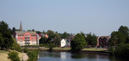
Photo 1. Mount Shiy. View from Erivanian
Of course, in fact, Toponym Shiy has nothing to do with any diseases with any diseases, the name comes from the Adygei "shy" - one and "PS" - a horse, a lone horse, but the disputes about what kind of mountain is roasting on the schis. The thing is that there are two mountains, they are located near the Erivan village, one is part of the highest point of the Georgian ridge, stretching from Shapsug to Erivanian, and the other stands next to the deep jumper. And here in some masses of Sisia takes the appearance of the vertices famous for its beautiful panoramic views, well visible from the Erivanian village, and in others it remains a modest mountain, with a single attraction - a rusty triangulation point on a woodcut-covered Makushka. I do not lead to all versions of the name of the mountain, I note that I most impresses one of two options - either to call a spicy height of 541, the one that is seen from the village of Erivanian, and another name to call the alternative name Mikhal, or call both mountains with an array of Schia. As on Mount Papay there is an eastern, central, western and other peaks and sewing can be called the main and eastern. But, the truth in this dispute is still not ourselves, so it turns out that we have a mountain suffering personality disorder. And I further in the story I will keep in mind called Shiy height 541, and the height 542 will be referred to as Mount Mikhal.
Shiy - one of the outstanding vertices of the foothill, the common top of it stretches from east to the west to more than a kilometer. The southern slopes emerging to the Valley of Arabin coolness are free from the forest and places even have rock outputs up to 80 meters high. From this, almost all over the vertex, excellent species open with it, for which we - I, Zhenya and Vitalik - went on the road.
From Krasnodar to Erivanian village a little more than 90 kilometers. First, the path lies on the federal highway A-146, Krasnodar - Verkhnebakansky (Novorossiysk), without reaching a few kilometers to Abinsk, we turn left. We pass Svetlogorskoye, Erivansky, the asphalt road ends behind it and the last 7 km by overcoming the country road. The primer to the Erivanian passing for any vehicle at any time of the year, but on the car there is to rush at a speed of 20-30 km / h - the suspension is a pity.
Winter roads are cunning. Immediately behind Krasnodar, a dense fog descended on the track, which was unwinding only for Ilsky. For some 40 km of "milk" counted 3 accidents, one of which is quite serious ...

Photo 2. Misty highway
At the Erivanian arrived at about 10 am. Before the entrance was stopped at the Erivanian pass, the Orthodox Cross was installed on it, it is difficult to skip it just from this pass one of the embodiments on Schiy. In the village, we arrived almost at the very beginning of the trail, to the street Podgornaya, saw the old woman in one of the courtyards, asked permission to leave the car at her house, Gabl would kindly allowed and promised to look after. We will go on the road.

Photo 3. On the transfer of Erivans. View of Mount Sisse Through Naked Crowns of Trees

Photo 4. Before entering the Erivanian. Ridge Kouchur on the horizon
From the street of Podgorny, the nameless lane, at the foot of the mountain, is shy in front of us in all its glory. The alley dives very quickly into the forest, moves the stream and dissolves in the forest, becoming narrow, but noticeable forest path. On it and begin the rise. The path goes from the east, to the end of the mountain, the bare crowns weakly cover landscapes and we see how the mountain becomes more and above. At one point, the slope directly becomes too cool and the path leads us to the right, bypassing. We gradually move to the northern, more gentle slope. And there is snow! Abundant snowfall was a year and a half ago, but for the 18th, everything was melted for a long time, at the bottom, and here, at first, the rare accommodation, and then the whole road was covered with snow, well blinded well, and therefore it turned out to be quite simple.

Photo 5. Beginning of the lifting on the mountain Shiy

Photo 6. One of the beams on the slope of the Schia Mountain

Photo 7. Before leaving the top of the sewage. On the road running on the north side
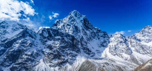
And so, the road makes the last turn and we are on top. For a second, the jaw opened, I expected good viewBut Shiy still surprised - the panorama is excellent. Smooth, extensive valley under his feet, on her silver snake river-hostess, full of full bang, a little further, the valley begins to gather dark folds and soon rests on Kotschur, which is visible from the top of the sewing in all its glory, from Thab's balls in the east, to Lysya, Chubate and ridges in the southwest. Somewhere in the West shelled behind the hills of the village of Shapsuga, the mountain sharply sticks out, richly polished by the saliva of various schizoturics, oh, I will get to Shapsuga " anomalous zone" Throw backpacks, taking pictures, drink tea, take pictures again. I'm leaving in the direction of the village. A couple of hundreds of steps and here is a new panorama. Wah! Handsome dad on the horizon and eryvanskaya at the feet, I shoot beauty and return to backpacks.
Panorama 1. The view from the top of the sewage on the Valley of the Albury, the Ridge of the Kouchur and the Erivanian Stanu. (if not displayed update page).

Photo 8. Erivanian village close-up from the top of Schia

Photo 9. Papay on the horizon, hiding in the haze. View from the top of Schia

Photo 10. Some surrounding peaks close-up

Photo 11. Valley of the Ambin River, view from the top of the sewage. Range Kouchur in the background
I note that from the car to the top of about 3 kilometers on the map, it is one and a half hours of walking the lift at the most unexplored step, even the last nausea and fragile young ladies are not broken and will rise to this top of the hour for two, it makes sewage one of the most easily accessible vertices with such high quality Views.
Lyrical retreat: I came to the mountain, do not be asshole, I carry the garbage with me.
Taking tea with chocolate, go further. Upper, barely distinguished path leads along the ridge of the mountain. On the left hand, a steep slope is almost a break, according to the right small rise, behind which the forest and pass to the northern slope. I note that there is no trace on the southern slope of snow. Dry stones and courageous grass. After 10 minutes, the path displays to a neatly knocked-down wooden platform, three-dimensional meters for three sizes, most likely, paragliders were made, which in warm time of the year love to start with steep slopes of Shiy. It is said that this is a rather complicated slope and flying here the real masters of their business fly here, it would be interesting to return in the summer and watch flights. The path in the area of \u200b\u200bthe site is splitting, one leads to the forest, north, the second continues his way on top, but soon rests on a dead end - a deep failure opens before the traveler, which begins the main part of the Georgian ridge. We went to the first branch. Snow appeared again under his feet, the tracks were noticed mostly similar to the dog, but very large, or a large dog or a wolf left them. Most likely the first, since I am not sure that the wolves remained in these parts.

Photo 12. Southern Schia Slope and Tropick on Top

Photo 13. River Ambin closeup

Photo 14. A slice of the village of Erivan

Photo 15. Tree on the slope

Photo 16. Wooden platform on top of sewage

Photo 17. The northern side of the top of the sewage. Forest smoking, Snow Snow

Photo 18. View from the wooden platform

Photo 19. Georgian Ridge
The trail turned into a direction and brought to the bottom of the jumpers between Schiy and Mihal, two entities of the mountain - the heroine of this story. The direction was quite quickly turned out again, not even in the path, but in the forest road. It was not long for it, not marked on the map of Rasklokov, led around the vertex, and it is necessary to look at the rusty triangulator! We are folded and altered, ten minutes later we have a goal. I take pictures of a triangopunk with a sign that resembles that this piece of iron is protected by a state, which is no longer. There must be a trail leading to the road through the Georgian, but where, in the navigator, the flip, in fact, begins steep, overgrown with a slope. Go again towards. After a few hundred meters for Mikhal, the direction turns back to the road and now we are already tearing on the Georgian ridge. Goal - Polyana in the middle of the ridge. Having reached them, stop at lunch. Poles on Georgian - this is an extensive, forest-free territory through which the country road passes through. On top of the forest, in its edges you can see a little surrounding mountains, and at one moment the haze on the horizon was sparing for a randomly rushing from the clouds of the sun's ray and the Crimean appeared. And so in general, the place is quite ordinary, but "for the check mark" a walk is quite worth it. If you continue your way through the glades, then an hour with a little you can go on the chapsuga highway - Abinsk, you can go to the glades to the right and go to the Erivan to the Erivanian, but it is already a pretty long way and we decided to return the same by what was successful and made. On the way back, they passed a little further along Shiy, they reached the cross in memory of the fighters who were arguing here during the Great Patriotic War. And the meat grinder, by the way, was a terrible, having a strategic value of the top several times passed from hand to hand until finally remained in the hands of the Red Army September 26, 1942.

Photo 20. Footprints in the snow

Photo 21. Triangulation point on top of Mikhal Mountain

Photo 22. Plate on the triangulation point

Photo 23. Northern Schia mountain slope. View from Mount Mikhal

Photo 24. Another kind of mountain papa. In the foreground, a fragment of the northern slope Shiy

Photo 25. Sedlovign between Shiy and Main Part of Georgian Range

Photo 26. Georgian Range Road

Photo 27. Poles on the Georgian Ridge

Photo 28. Krymsk on the horizon. View from the Georgian Range

Photo 29. Another panorama of the Erivanian village from the top of Schia

Photo 30. Cross on top of Sisse

Photo 31. Fresh traces on Shiy

Photo 32. Return to the village
The trails marked on the map again did not turn out and we went down to the car in the same way. On the clock the beginning of the sixth evening, it is felt. The whole hike stretches for thirteen kilometers and took about seven hours in time. You can, of course, it would be twice as fast, but Shy is that place where I do not want to rush. I would like to gain an extra mug of tea and silently sit and admire the gray peaks of the coathur, the silver ribbon of Abin and the gloomy January sky.