According to some of the most worthy and great Russian writers, poets: "Who did not breathe the mountain Caucasian air - he did not live ..".
In this article we will tell about Caucasian mineral waters. The good this resort of the Caucasus and that unique in min. waters
The Caucasus is not just a mountain, gorgeous nature, springs, sources, eagles over the gorges, viper on the mountain roads between Rhododendronov's bridges, the Caucasus is a special spirit, special cultureThis does not meet anywhere else, harsh, wild, proud, very beautiful, in some places the virgin region.
Caucasian mineral waters are a group of resorts of federal significance in the Stavropol Territory, a particularly protected Ecological resort region of the Russian Federation.
South of the European part of Russia. The resort includes cities and territories:
"Region-agglomeration Caucasian mineral waters having an area of \u200b\u200bmore than 500 thousand hectares (5.3 thousand square meters), located on the territory of the three constituent entities of the Russian Federation within the borders of the Mining and Sanitary Security County:
in the Stavropol Territory - cities and resort cities Georgievsk, mineral waters (including the resort of Kumagorsk and Naguta resort), Pyatigorsk, Zheleznovodsk, Lermontov, Essentuki, Kislovodsk, as well as the actual areas of Georgievsky, Mineralovo and Pre-region, - 58% of the entire area of \u200b\u200bthe region;
in Kabardino-Balkaria - the Solsky district, - 9% (therapeutic mud of the lake Tambukan, the Valley of Narzanov and the other);
in Karachay-Cherkessia - Malokarachayevsky and the Skubansky districts, - 33% of the territory (zone of formation of mineral sources). "
The location of the resort, gently say, gorgeous:
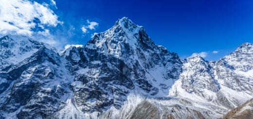
"The Caucasian Mineral Waters area occupies the southern part of the Stavropol Territory and is located on the northern slopes of the Chief Caucasus Range, just a couple of tens of km from Elbrus. The other here seems to earth, others - the sky.
From afar, fixed white clouds are visible, which when approached are snow vertices. Caucasian Gor.. The southern borders of the district are the foothills of Elbrus, the valley of the Khasaut and Malki rivers; in the West - the upper shovels of the Eshkakon rivers and a depressing; The northern border of the district is the city of mineral waters, followed by the steppe spaces of the Precaucasia. "
Very close to the Stavropol Territory famous resorts Krasnodar Territory, Sochi:
"In the West and Southwest, Stavropol Territory borders with Krasnodar Territorynorthwest with Rostov region, in the north and northeast with Kalmykia, in the east with Dagestan, in the south-east with the Chechen Republic, in the south with North Ossetia-Alania, Karachay-Cherkess and Kabardino-Balkarian republics.
Caucasian Mineral Water Resorts in Video:
In Caucasian mineral waters, many sources of mineral waters, because the region is not easy to be called. The name of the most important city is Essentuki - is a few decades for a couple of decades.
And the driver really possesses therapeutic properties, unlike that products, which are clogged shopping shelves.
In addition, there are many springs in the region, waterfalls, salt, mud sources.
The resort has existed since the beginning of the 18th century, more precisely, the first mention of it is dated to this time. All forces were sent to the arrangement of the region, so in the 20th century the resort became the largest in Russia, and the most healing.
Self famous cities and the resorts of Caucasian Mineral Waters:
Kumagorsk
Nazhby
Zheleznovodsk
Pyatigorsk
Essentuki
Kislovodsk
Kislovodsk The highest high resort, it is located at an altitude of 817-1063 m above sea level, the lowest mountain dot kislovodsk - 750 m above sea level, and the highest - 1409 m (on a large saddle in the Kislodsky Park).
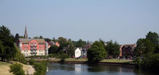
"Kislovodsk is located in the south of the Stavropol Territory, almost on the border with Karachay-Cherkessia and Kabardino-Balkaria, 65 km from Elbrus Mountain.
The city is located in a small and cozy picturesque valley, surrounded by the slopes of the main Caucasus ridge and formed by the gorges of two merging rivers - Olkhovka and Berezovka, flowing into the river depress. The length of the valley from the south-east to the North-West is about 7 km. "
Almost always good weather here:"The climate of the Kavminvod region has long been highly appreciated by the resortologists and is successfully used as therapeutic factor. The main advantages of the local climate are associated with a large number of sunny days - in Kislovodsk only 37-40 days a year can be without the sun.
Here is relatively dry, the wet air masses from the Black Sea do not reach here - they are delayed by the main Caucasian ridge. "
« By the number of sunny days, Kislovodsk is not inferior to the best resorts of the world.On average, for the year, the number of clear days in Kislovodsk is about 150, while in Pyatigorsk - 98, in Zheleznovodsk - 112, and in Essentuki - 117. The number of cloudy days is also small - an average of 61 days per year.
The air in Kislovodsk is always clean, mostly dry and invigorating. Kislovodsk stands out among other resorts Kavminvodvodvod, mostly quiet, without strong winds with weather and low humidity in winter, which fluctuates from 56 to 70%, which has a beneficial effect on the well-being of the resort workers. "
In January, there were 18 degrees of heat, minus temperatures reached 20 degrees, but much more often the temperature at this time of the year is here about zero or "light minus". The hottest months - July, August, temperature, depending on finding near or in the remoteness of mountains, snowy gorges, from 4-5 degrees Celsius to 37 degrees of heat.
All the resorts of Caucasian Mineral Waters are primarily therapeutic, but Kislovodsk, Essentuki, Zheleznovodsk - especially. After Sochi Kislovodsk the second city by the number of health resorts, sanatoriums.
A third of all therapeutic and preventive institutions of the region is here. In Kislovodsk there is a source of a famous acidic mineral water - Narzan.
Built on the site of the former fortress, the city is now replete with green plantings and fruit gardens, in numbers - a very small town: 130 thousand people.
Most Kislovodsk resistants have a healing profile on the prevention of cardiovascular diseases, nerve diseases and respiratory organs.
In addition to healthcare, mineral springs and other beauty of the city, one of the brightest attractions is a resort park, its area is 948 hectares, which is comparable to the huge city parks in Europe and the world.
"The park is located on both sides of the Olkhovka River and contains over 250 species of trees and shrubs, including cedar, fir, birch, pine, spruce, black walnut, Chinese Pavlonia, cork tree, etc. In the alpine part of the park on alpine meadows More than 800 species of grassy plants grows.
The park contains nurseries of ornamental plants, greenhouses. Over 80 varieties of abundant blooming roses are planted at the "Rose Square" and in the "Rose Valley". In the park, proteins were acclimatized, trustingly taking food from the hands of people, various species of birds.
The monument of nature is the red stones, which go out in several places of the park and are sandstones, having a red-brown color and a variety of weathered forms. "
The park has a route for the Medical Walking - Terrekur. And in Kislovodsk itself several dozen major and popular sanatoriums.
Despite the fact that the resorts and cities are located close to each other - the atmosphere in them is quite different. So, in Zheleznovodsk, another air, a little different climate - compared to the rest of the Caucasian Mineral Waters resorts.
"Zheleznovodsk - The most dynamically developing resort Kavminvant. In 2003, he was awarded the title "The Best City of Russia" among small cities.
The climate here is mountain forest, similar to the medium Alps climate. Long-term meteorological observations made it possible to attribute it to mining and forest average alpine, moderately dry.
Air is saturated with oxygen and wood phytoncides. Moderately hot summer with cool nights, a large number of sunny days with weak refreshments, winter is not cold. "
Zheleznovodsk population is only about 25 thousand people, but despite the small number of residents - the city in truth is a pearl not only among the resorts of the Stavropol Territory, but also of all Russia.
Yes, there are few residents, and guests are more: so, the health resort (about two dozen sanatoriums) of Zheleznovodsk can take up to 80 thousand tourists. The direction of treatment is mainly - diseases of the digestive, kidney organs, metabolic disorders.
Over 20 sources of mineral waters and several mud.
Pyatigorskmore, so let's say, "is amazed by industrialization" than small in the number of citizens and remote cities of Stavropol. In Pyatigorsk, about 145 thousand inhabitants, well developed industry, trade, scientific sphere.
"The city of Mashuk is located in the city (993.7 m, with a 112-meter television tower with a 112-meter TV) and its spurs.
The climate in Pyatigorsk is characterized by soft winter and hot summer. Thanks to a large number of water resources and a soft climate, the city has picturesque reservoirs, forest belts and parks.
The resort area rich in underground sources of mineral waters is relatively poor in surface water resources.
The tourist infrastructure of the resort of Pyatigorsk includes:
More than 30 resort health care facilities. Annually, there are over 200 thousand people per year (225-250 thousand people per year in 16 sanatoriums and 7 pension - in the II half - the end of the 80s);
43 tourist firms and organizations;
17 hotels;
The city and Pyatigors have possess colossal tourist potential and have the right to compete with leading european resorts and balneological health resorts. "
In Pyatigorsk, many museums, theaters, historical monuments, libraries, beautiful places. In the city of Parks, fountains.
"The surrounding mountains decorate natural forests in which mighty oaks and snow-white birchs, honey beef and linden grow, and the dogs, hawthorn, rosehip, Barbaris, Ryabina blush on the autumn.
The animal world due to the proximity of the city is not so diverse, but tourists invariably please the proteins that can be found even in small squares in the very center of the city. On the pond of the Kirov Park in the summer Swans float. "
The population of about 105 thousand people, many resistant, more than 20 mineral springs, the main direction of treatment - "diseases of the gastrointestinal tract, liver and metabolism."
Festivals are held in Essentuki, cultural events, there are a lot of cultural institutions.
The resorts of Caucasian mineral waters are not good to wear this name: the main attraction and the main treasure of the region are sources of mineral waters. And if someone was not here - then all the mineral water drank everything.
In 2000, almost 500 thousand people were restored here and corrected their health.
The program "Genius Places" describes the attractions of the Caucasian Mineral Waters:
Caucasian mineral waters in the first places in popularity among Russians among Russian resorts:
"The Association of Tour Operators of Russia (Ator) analyzed the most popular directions of domestic tourism in the summer of 2014, the resorts of the Krasnodar Territory (Sochi, Anapa, Gelendzhik, Tuapse) were on the first line of the ranking (Sochi, Anapa, Gelendzhik, Tuapse), on the second - Crimea, at the third, fourth and fifth line, Caucasian mineral waters are located, Golden ring And Karelia, respectively, Baikal took the sixth position. "
Performed: Zabolotnaya Christina and Kolesnikova Yana
Caucasian Mineralnye Vody is one of the most populated territories of the North Caucasus. The average population density is more than 150 people per 1 km 2.
Caucasian Mineralnye Waters include 7 cities:
Kislovodsk
Essentuki
Pyatigorsk
Zheleznovodsk
Lermontov
Mineral water
Georgievsk.
As well as 3 district - pre-saying, Mineralovo and Georgievsky.
Caucasian mineral waters are more than 500 thousand hectares (5.3 thousand square meters), located on the territory of three constituent entities of the Russian Federation within the borders of the Mining and Sanitary Security County:
in the Stavropol Territory - Cities and Resorts Georgievsk, Mineralnye Vody, Pyatigorsk, Zheleznovodsk, Lermontov, Essentuki, Kislovodsk.
There is a region in the south of the European part of Russia, almost at the same distance from the Black and Caspian seas, - within the junction of the mineralodes of the inclined plain and the northern slopes of the Big Caucasus.
in Kabardino-Balkaria - the Solsky district, - 9% (therapeutic mud of the lake Tambukan, the Valley of Narzanov and the other);
in Karachay-Cherkessia - Malokarachayevsky and Prikubansky districts, - 33% of the territory (zone of formation of mineral sources).
There is a region in the south of the European part of Russia, almost at the same distance from the Black and Caspian seas, - within the junction of the mineralodes of the inclined plain and the northern slopes of the Big Caucasus.
History.
KMV is one of the oldest resort regions in Russia. The first written information on its mineral springs is found at the doctor of the city of Schever (1717), which was sent by Peter I for the mineral examination clauses North Caucasus. The first detailed descriptions are made by I. A. Guldenztedt (1773), and then P. S. Pallas (1793). After studying the hot spring in Pyatigorsk (1801) and the conclusions of the Special Commission on the possibility of using Minvod with therapeutic target (1802) by Decree of Alexander I dated April 24, 1803, the provision on the Kavminvodes was approved when historical rescript was signed on the recognition of the state importance of Caucasian Mineral Waters And the need for their device, "and their official existence of as a resort area began.
The history of the development of this unique resort region of the Russian Federation was characterized by takeoffs and drops, with the transition from public administration to a private counterparty. Long distances from the central cities of the Russian Empire, when those who wish to get on hot, iron and acidic waters were forced to make the most real journey on horseback crews duration of one and a half or two months, military operations in the Caucasus, the uncomfortableness of the sources and resorts themselves - all this created certain difficulties in Development of Caucasian Mineral Waters.
Relief
The relief of the Caucasian Mineral Waters begins at the foot of Elbrus, where the rocky ridge with a number of vertices is clearly distinguished. The dissected relief that creates a wide variety of landscapes is explained by a long development and complex geological structure of the territory. The northern part of the Caucasian mineral waters is open, it is reviving the mountain-laccoliths - the failed volcanoes: Magma could not pass the sediment and frozen in the form of domes. The southern part of the area is cut in deep gorges and beams. All local mountains are laccolites, that is, stone pit. About 10 million years ago, the formation of mountains began in the area. Magma climbed the narrow cracks in the earth's crust, making his way up, raised the layers of the Earth and somewhere to do the surface. On other mountains, lava masses were exposed at the expense of the process of weathering and blur. Temperatures for powerful eruptions lacked. But a set of chemical elements and minerals, filled with these stone pit, turned out to be unique and identified the amazing variety of mineral waters of future resort cities.
Caucasian Mineralnye Waters (Kavminvoda, KMV) - a set of cities of the federal significance in the north of the central part of the Caucasian mountains. The conglomerate of the resorts is successfully located between the Black and Caspian seas on the square with a length of more than 500 thousand hectares.
The lands are widely known hundreds of unique useful sources that can cure a number of unreasoning. In addition to water resources, there is a unique lake Tambukan, rich in the deposits of lively mud.
The ownership of KMV covers the land of three regions of our country:
- Stavropol Territory unites the cities-health disentucky, Zhelemnovodsk, Kislovodsk, Lermontov, Mineralnye Waters.
- Kabardino-Balkaria with Lake Tambukan with Ilova Mud and Darzanov Valley.
- Karachay-Circassia is considered to be the place of origin of education water sources.
- Conglomerate cities unites all healing resources to a huge artesian pool with gravel waters. That is why Caucasian mineral waters are considered the most environmental protection area of \u200b\u200bRussia.
The surroundings of the KMV are inherent in a soft moderate mountainegery microclimate. Healthless people are located just 85 km from Elbrus, the highest point in Europe. The highest snowy top of the mountain is visible from almost any place of the region. On Kavminds, mountains are placed among smooth steppes:, bull ,.

The inclined terrain is covered with dense oak-shaped forests. The proximity of the snow-covered vertices of the Caucasian ridge? On the one hand, KMV, and the desert with the steppes off the coast of the Caspian Sea on the other - the moderately continental climate is determined. Due to the fact that it is formed in the valleys closed by mountains from the winds, the health resort is considered also climatic.
The main cities of KMV
Caucasian Mineral Waters - Unique Resort Sanatorium Square, where there are real natural storage rooms in various composition and healing properties of water. In total, CMB includes about 130 sources, and a little more than 90 of them are used in medical purposes. The largest underground deposits of carbon dioxide are distributed through the territory of four administrative units: and.
This list can safely be considered a unique healthclayer not only Russia, but also the whole world. It employs about one and a half hundred sanatoriums, which are equipped with special diagnostic equipment for mineral treatment. Every year, Kavminvory visits approximately 700 thousand tourists. Holidaymakers also attract the mountain peaks, endless valleys with thick vegetation, fresh alpine meadows, azure waterfalls, blue rivers, as well as purest air with saturated aromas of resins and needles.
Essentuki
Balneological drinking low resort located at an altitude of about 600 m above sea level. The city is surrounded by mountains of different heights, so that the contrast microclimate with dry hot summer and rainy frosty winter prevails here. A chic view of Mount Elbrus and the main Caucasian ridge opens throughout the resort town.

Essentuki subsoil is rich in carbonic sodium chloride-hydrocarbonate waters. The most popular of them: "Essentuki-4" and "".
Back in the depths of local land, carbon dioxide hydrogen sulfues of medium mineralization occur. The resort is suitable for drinking drinking and outdoor procedures (baths, irrigation).
Resting here you need people with diseases:
- digestive tract;
- duodenal estate;
- liver;
- biliary tract (viral hepatitis, chronic hepatitis, chronic cholecystitis);
- metabolism (obesity);
- endocrine (diabetes at an early stage).
Zheleznovodsk
The city literally is considered to be pearl Kavmin. The acclimatization zone here has a huge amount of heat, and the nature of extraordinary beauty. Thanks to the location of the city on the Municipality Alps, a mining microclimate prevails. The weather is light in winter and non-sucking summer. Zheleznovodsk is surrounded by the slopes of Mount Beshtau and the iron, on which thick beech and oak forests grow. In the mountainous surroundings, endless trails are laid terrenkuras for walking, which provide a wellness effect due to calculated physical exertion.

As for deep-water sources, the same type sulfate-hydrocarbonate calcium-sodium water is dominated by small mineralization. They are used for drinking and outdoor balneological procedures. Rods are cold and hot, and there is also bitter-salt mineral waters. Bottles bloom from Smirnovsky and Slavic sources.
The resort is shown for people with diseases:
- gastrointestinal gaps (gastritis, ulcerative illness of the stomach);
- duodenal estate;
- kidney;
- urinary tract.
Kislovodsk
The city with a temperate climate of lowland, suitable for the treatment of diseases of nervous and cardiovascular systems, respiratory organs (including bronchial asthma). Scientists have proven that a long stay under the sunny beams of Kislovodsk in the summer can slow down the development of atherosclerosis and hypertension. Winter is dry and clear here. The area can be distinguished by the stability of atmospheric pressure, which is very well affected on the healing process.

The Kislovodsk deposits are represented by the world-famous source of Narzan with boiling carbon dioxide boiling water, which is useful in the form of baths and drinks. Kislovodsk Narzans belong to sulphate-hydrocarbonate magnesium-calcium sources. Their main difference is the magnitude of mineralization. In total, there are 3 types of water: the main, dolomite and sulphate Narzan.
In Kislovodsk, you need to come to people with diseases:
- blood circulation systems;
- heart disease;
- coronary artery disease;
- angina;
- hypertension (first 11 stages);
- diseases of the nervous system;
- atherosclerosis of brain vessels;
- diseases of respiratory tract (outside the exacerbation period).
The resort is located in the center of KMV on the slopes of Masheuk Mountain. The feature of the city is in a huge variety of healing procedures. Carbon dioxide, nitrogen, hydrogen sulfide, salt-alkaline and radon waters of complex ionic compositions are accumulated here, as well as sulfide dirt of the lake Tambukan. Ilovy dirt have a strong bactericidal effect, and still contain a large number of organic compounds, methane and hydrogen sulfide. In addition to balneotherapy, it is widely developed, climatotherapy, aerotherapy, balneherapy and radonotherapy. Bottled water is bottled under the names "Mashuk-19", "Goryachevodskaya" and "Pyatigorskaya dining room".

Indications for visiting health resorts:
- diseases of the peripheral nervous system;
- problems with the musculoskeletal system;
- diseases of the digestive tract;
- skin diseases (eczema, neurodermatitis, psoriasis);
- cardiovascular diseases (atherosclerosis, burgher disease);
- female inflammatory processes;
- polyneurite.
Remarkable places Kavmintorv
Caucasian mineral waters are famous for both interesting expanses. A large number of hospitals, sanatoriums and blesses is located in architectural monuments that were built in 19-20 centuries. For example, one of the amazing buildings that deserve attention is the neoclassical mud of Semashko in the city of Essentuki, Central gallery For drinking treatment in neo-neo-style and main nasal baths in modern style on the Kislovodsky resort.
Seats near Pyatigorsk and Kislovodsk it is impossible to mention without all the favorite poet Mikhail Lermontov, who repeatedly mentioned the Caucasian mineral waters in their works. In KMV, it is necessary to visit the mountain "Ring" in Kislovodsk, as well as a gazebo "" in Pyatigorsk. It is located here, and next to him and Martynovsky, as well as the first place of the burial of the poet.
The surroundings of Cavminvant are rich and picturesque natural places. Here you will see incredible beautiful mountains Beshtau, Mashuk, and also covered with a snowy cap the top of the highest point of Europe. You can also enjoy endless breathtaking landscapes of forests, rivers and waterfalls. Do not forget to visit the Narzanov Valley, after all, 20 water sources are made from it, different in their composition.
How to get to kVM
A plane from Moscow flies into mineral waters. The flight time is 2 hours. Then to the city of destination there is an opportunity to get to a taxi or a minibus.
There is a budget option - the train with the route "Moscow-Kislovodsk", the trip time will be 27-35 hours. Along the way there are stops in all resort settlements, with the exception of Zheleznovodsk. To get to this stop, you must go to the Beshtau station and get to Zheleznovodsk on the minibus, and the time on the way will be only 20 minutes.
Railway, then the center - Beshtau, the name of which can be translated as a five-year. In general, the number 5 for KMV is some kind of special: Beshtau 5 vertices, 4 satellite mountains (peeling, stupid, acute and honey) and 4 neighbor's mountains - Mashuk, snake, iron and roller, and this "five in the five in the top five five "forms the center of the entire placer 17 lonely Mounts KMB. Another 5 historical cities, the largest of which is Pyatigorsk, in which 5 railway stations ... I think there can be a lot of other "pyedrok", therefore it's not by chance that one of the names of the KMV region, and even the entire adjacent part of the Caucasus - Pyatigorsia .
Mount KMV is a laccolite, that is, the lava dome, squeezing from the mantle millions of years ago. Beshtau is the largest (8 kilometers in the diameter) and high of them (1401m). But I did not get on any of her vertices, limiting the hike on the slopes from Pyatigorsk to Zheleznovodsk. And on the road - uranium mines, the second-Afonov monastery, the city of Lermontov, the most beautiful eagle rocks and the warm April Forest.
For the first time I saw Beshtau from afar, I thought that she would not be on the teeth to me, but in fact it's not so difficult to go back to the central vertex. Especially the mountain is crossed by numerous roads, and there are several comfortable lifting on it. The easiest - from the station Lermontovskaya (see last part), the surroundings of which I reminded me of scenery to the scenes of gangster disassembly from the cinema of the 1990s. The fact is that the largest car market here is located in the North Caucasus, serving primarily the republic, where authodillers are discovered very reluctantly. In the background - Mashuk, unmistakably identified by the TV /
To the left behind the car market with its dumps already in the morning the dubious personalities of the Russian and Caucasian appearance, and the road to Beshtau begins. Ahead of the top two brothers (1124), Bolshaya Beshtau (1401) and goat rocks (1157), and on the title frame form from the opposite side - goat rocks, Big Beshtau and Small Beshtau (1254), hiding behind the shaggy mountain (1180). The first kilometers the road goes through an unpleasant area with concrete fences and the ruins of some kind of industry:
On the left hand - Pyatigorsk. Garden partnerships Lake Ivushka, high-rise buildings with a poetic name White chamomile (according to pre-revolutionary tuberculosis sanatorium - in those days this flower was a symbol of combating a car), a long forest Dubrovka on a shaved grief (since half of her bald) and the farthest of 17 mountains Yeta (973) and Jun (1190), followed by the Caucasus.
But the center of Pyatigorsk is not visible from here - he at the foot of Mashuk:
But from the flowering bushes at the foot of the goat cliffs appears the old industrial abandon. This "village №1" - nothing more than the remains of the processing factory of uranium mines, very unexpected in the resort area.
The local laccolites consist of quite complicated breeds - I have already written in one of the past parts about Beshtaunit - a solid and corrosive stone used in the technique. And here there are davidites and Lermontovitis - uranium-cerium ore. In the coming Cold War of the USSR, the USSR was in dire needed in uranium - raw materials for atomic warheads, and mined it where he could - a few months ago I had already shown the first Soviet in (Kyrgyzstan). Beshtaugorsky Uranus was known since the 1930s, the "village №1" was built in 1949-53, and the prey on it was carried out until 1976. By analogy with the same Meluuu-Suu, most likely the surviving building was a factory-powered power plant - the rich Farika itself had to demolish as "dirty".
They say Beshtau everything is exist with galley, forming the largest catacomm system in Russia long by different data from 160 to 230 kilometers. The inputs in the gallery are marked on Wikimapia, but the notes of the person who visited them inside them.
Cenuteno, Uranus could not not give rise to traditional horror stories: allegedly, and the background on the grief that is in Chernobyl, and the mushrooms are growing giant, the local people will never buy, but there are no unlucky tourists. And they worked in these mines prisoners and there were buried ... In short, I do not take judge about the reliability of rumors. Beshtau is a place and without any radiation. And you can go to it several times - for example, on the slope of Big Beshtau there is a so-called Sun Temple, which many consider Scythian Megalith (what am I confessing, I strongly doubt). But I took the course to the top of the top two brothers - and I suspect, the name of this grief was given those two remains on her "facade":
Approximately 4 kilometers from the Lermontovskaya raising station ended - I went out on the annular road built in 1927, all 5 vertices at a good height. She herself runs roughly on the same level, then climbing, then dropping, and I turned left, heading clockwise:
Along the road - the forest, the slope on both sides, the abundance of flowers and stones. On some stones - biblical quotes: aspalted part of the road leads from Pyatigorsk to the second-Afonov monastery, which, however, a few more kilometers.
Sometimes the warm forest on the slope is broken, opening the Panorama of Pyatigorsk.
Already familiar to Yuts and Jun, and right at the foot of a low pine slide, also like a laccolite.
A wide field and Stalinka with a tower is not an abandoned terminal of an old airport, and founded in 1885 by the racetrack from the station's station - one of the two federal significance in Russia, along with Moscow.
And the Caucasian peaks, which I won't even try to identify, but apparently it is Kabardino-Balkaria, east of Elbrus. Itself highest point Russia on this day was not visible behind the clouds lying on her slopes, but on other days it loomed in the background more than once.
Behind the back - Mount two brothers:
And the Abris Camel Mountains (885m) - the most western of 17 laccolites, is evaporated, it appears first in sight on the road from Stavropol. On the slopes, as you can see, there are many cars - Beshtau is also popular with the resorts, and at the local, and even the jeep with the numbers of South Ossetia also saw here.
We continue the path to the monastery - in fact I went for a long time, one and a half hours, hoping to see the temples behind each turn. Here on this rock are going to recreate the icon, adorn the breakdown to the revolution:
In the meantime, only such a memorial plaque - probably crashed about this rock by car:
And finally, the Second-Afonov Monastery itself arises against the background of Big Beshtau - as strange and at the same time, the Russian Church is organic in the mountains! This is the temple of George Victorious (1999), but the cylindrical building is such an original fraternal case:
The monastery founded two monks from Greek Afona in 1904, and since the New Athophone Monastery in the Caucasus was already 30 years old, called the second-Afonov. In those days, he was known for its strict charter and loyalty to traditions, so very quickly hesitated in the age of modernism and renewed the glory of the fatal of genuine Orthodoxy. In 1927, the second Athos closed, and gradually destroyed - this is how his Assumption Temple (1906) looked:
In the new church, apparently want to beat Greek motifs, and in general, I would say that the second-Afonov monastery in the architectural monastery was more interesting to be reborn in 1997-2001.
For example, the church under open sky - They say, they wanted to build a new cathedral here, but they refused the idea due to the threat of landslides:
At the past, see the crevice between the "eagle" and a lonely post a little right? I went there:
The view from the clefts on the pendant mountain and three cities near it:
The view of the forward - as you can see, I'm not alone here, it was passionately lazy with two families - wives and boys for 10-12 years old. I think, on weekdays, Beshtau is not so crowded, the more I was not just here on Sunday, but for Easter.
For the next turn - the abyss, and between the rocks is visible Zheleznovodsk:
On the "Eagle's Head" it turned out not so difficult to climb - steep turns on the path are equipped with even improvised handrail:
And the round site at the top of the time reminded me of the spot of Pechorin's duel with Martynova, and the rock where the screaming "Give the sausage!" Father Fedor - without anything, neither to others, it serves as the ideal way of the Precocality in the imagination of the Russian writer.
Top of a cliff with a small grotto:
And view through this grotto:
Closer the mountain is acute and stupid (767m, also kabanka), then - bull and camel. Two cities are again in the frame - on the left of Lermontov, on the right of Zheleznovodsk. And at the bottom is not the military unit (as I thought), and the huge abandoned pioneer in the "Orline Rocks":
To the right - another interesting mountain quintet. Left - stupid and bull, on the right - hanging over the Zheleznovodsky iron (853, closer) and the rumble (926, on), and in the midst - honey mountain (725m), the last of the "satellites" Beshtau:
It is on the background of the non-smoke part of Zheleznovodsk:
Zheleznovodsk is a small town (24 thousand inhabitants), but it works very interesting. Its center and the resort part - in a narrow (less kilometer) the valley between Beshtau and the iron, and the main part of the residential areas is on the plain east, and this isolation of the resort area gives it a chamber.
The most important sights - at the left of the Ostrovsky bath (1893) at the station, at the top of the left - the Palace of the Bukhara Emir (1912, really essentially a personal sanatorium, who built the ruler of Vassal Bukhara), right at the top - Pushkin Gallery (1901, Round), Well, At the bottom of the local administration.
To the left - the Pokrovskaya Church, arranged in 1996 in the building of the new baths (1912), and the house with the turret below - on the station Square:
And in general, I decided to go to Zheleznovodsk. But first had to go down. And here I strongly drunk - from the cliffs tears without any problems, and then I decided not to walk back, but look out some trail. Throughp trails were true, but they walked up, and I was tired and went for the one that went under a slope. She eventually dissolved in a rather steep slope, through which, through the stones, fallen leaves and flowering herbs, I decided to descend. The descent turned out not to be dangerous but boring and heavy. In one place, I grabbed a thick dry branch, she broke out and right in his hand with a decent speed on the inertia flew to my eye. I somehow managed to climb a miracle, but the blow turned out that a natural echo was given in the head. Not so much from pain, how much did I get up and realized that I'm afraid to open my eyes - what if I was now a curve?! But she opened, and it turned out that I see everything as I saw before, only the "blind spot" was held for another 20 minutes. Later I found that there was no bruise left, nor even hemorrhage left from the blow, although it was smashed somewhere inside the eyes a couple more weeks . In general, I can not fall away from the thought that everything is dangerous from people ... However, for the first time on the road, he received not from the gopnik of which, but from the tree. Soon I again went on a flowering led ring road:
And turned into a direct descent to Zheleznovodsk, which is 2-3 kilometers under the slide:
Palace of Bukhara Emir and Soviet buildings of the Sanatorium named after Telman. It seems that the first time was walking out of the city to the city (except for my periodic walks from the house in the neighboring Lyubertsy):
The road brought me to the station here is behind these trees. By the way, how I corrected me
According to the nature of the relief, the Caucasian Mineral Waters Area is divided into two parts: the northeast, where mountain-laccolite mountains are tested against the background of the plain, and south-west with characteristic features of the mountain landscape. In the southwestern part, it lies a rocky ridge to the relief, from which the hollow goes down to Kislovodsk Bermamy Plateau with flat tops of the mountains large (2,643 m) and small (2,592 m) Bermamat. With these vertices, a majestic panorama on the main Caucasian ridge from the highest peak of Europe is located - Mount Elbrus (5,642 m). About 40 thousand years ago Elbrus was actively acting volcano. Since then, he is calm, but scientists have proven that there are formidable volcanic forces in the deep depths of this mountain, which can be used by a person. On the Bermamat Plateau is located Mount Shatzharatmaz (2 140 m), on which there are a mining and astronomical station, a meteorological station, the scientific framework of the Institute of Physics of the Atmosphere of Russia. Northeast Bermamat Plateau is a pasture ridge, divided into two parts of the river depress. One part is the name of the Ginal Range, the other - Daryin heights (1 300-1,500 m above sea level). From Dariain heights to the northeast of the hollow, Borgastansky plateau is descended. In the middle of the steppe zone of Caucasian mineral waters, 17 exclusively peculiar mountain laccolites will come out: Beshtau (1,399.8 m), Jutu (1 198 m), snake (994 m), Mashuk (993 m), Yeta (972 m) ), Relinking (930 m), Golden Curgan (884 m), camel (885 m), acute (881 m), iron (859.4 m), peeling (875 m), bald (740 m), honey (721 m), Cockurstles (406 m), bull (821 m), Cabanca (stupid) (772 m), Mount Dagger had an acute peak ridge and rose to 507 m, but when developing stone, the top of the mountain was cut off. Ancient volcanic processes created these mountains. The power of the magma's underwashing land was insufficient to exit the outside, and magma, magmatic gases and couples only raised some parts of the earth's surface, forming dome-shaped vertices. Where Magma found a way out, she froze in the form of naked rocks. A small height of these mountains, the presence of gentle slopes and rich vegetation make them accessible and attractive to the organization of near tourism.
Beshtau (five mountains). The main Mountain Beshtau, called the poet five-win, has indeed five vertices, from here and its name (from the Turk. "Bech" - five and "Tau" - Mountain). It is the highest of mountain-laccolite, located in the center of the northeastern part of Caucasian Mineralnye Waters. With its vertices are visible all the mountains-laccolite, panorama of the resort area and the mountain chain of the Caucasian ridge. Beshtau consists of five vertices: Beshtau, Small Beshtau, two brothers, goat cliffs. Beshtau slopes are covered mainly by deciduous forest. Up to the height of 1100 m, the slopes are covered with a beech-oak-yasenevo-robber forest, which makes up the main part of the Beshtahn forest massif, consisting of more than 60 species of trees and shrubs. The planting of the Eastern beech is in it in 177 hectares. In the subalpine zone, the wide forest is replaced by crumpled with cold-resistant birch beard and rowan Caucasian. The above is the zone of the settlement subalpine meadows, forming at the main top of the Polyana with an area of \u200b\u200b461 hectares. It meets representatives of a typical subalpine meadow flora - primrose adorable, Wilhelma mint, Rhododendron Yellow. Among the endemics of the mountain is known to be a brawl, characterized by very large flowers. The forest is rich in mushrooms, mostly lamellar (especially champignons, chanterelles, waves, gruses, umbrellas). The mountain fauna is also distinguished by a variety: boars, birds of prey, pheasants, hares, foxes.
Rise to the top of the mountain best from the side of Zheleznovodsk or Lermontov.
Snake (from Turk. Zlak-Tau - "Snake Mountain") - the remaining igneous (paleovulkanic) mountain. Height 994 m. Nature Monument. The second on the area of \u200b\u200bMountain Pyatigora after Beshtau, occupies a territory of about 20 km². Located 4.5 km south-west of the Mineral Water Railway Station. The plan has poorly elongated in the northeast oval shape. The upper part is composed of subvulkanic intrusion of Beshtaunites, forming a picturesque rock of 2.8 km². At the bottom of the slope, the clay shales of the Maykop series prevail, places overlapped with the rest of the cover of non -ogenic volcanic rocks - tuffs and a tool. The destruction of the vertex body of Beshtaunites led to the widespread development of stone shots.
The south-western foot of the mountain is a Zmeikinskoye deposit of carbon dioxide hydrocarbonate-sulfate calcium-sodium water with mineralization of 3.2-5.6 g / l. The main part of them is mined with a well from a depth of 1482 m. The water temperature at the mouth of the well 70-74 ° C, the flow rate of 9 l / c. Eastern and, partly, the southern and northern slopes of the mountain are violated by an extensive quarry, in which in the 30-80 years of the XX century was mined for the construction purposes of Beshtaunit. The quarry is an extensive artificial exposure of about 2 km long and a height of up to 200 m. It observes the features of the occurrence and the inner structure of the subvulkanic intrusion of Beshtaunites, their relationship with enclosing sedimentary rocks, as well as the remnants of the cover of non-heaked volcanic tuffs, which determine the scientific value of this production. After stopping the extraction of stone in the quarry, the natural restoration of vegetation cover occurs.
The mountain is covered with forest and mountain-meadow vegetation, which is part of the northern part of the Beshtaugorsky forest massif. Grabovo-yasene-oak and grab-boring forests prevail, which have about 60 breeds of trees and shrubs. At the top of the forest, the forest is replaced by the meadows of the subalpine meadows, and in the foot of the meadow-colored metropolitan-cereal steppe with high species saturation. From rare protected species of plants on the mountain, the beech east, a dwarf bequeck, Kisser Nefedova, Rosehip Long, Caucasian, Caucasian, Lilia, Single, several types of hawk.
Is the edge complex (landscaped) monument of nature
Mount Mashuk. To the north-west of Beshtau in the form of a shaggy hat, Mashuk rises - one of the most interesting mountains of the Kavminsky district, which is also the best panoramic point in the nearest surroundings of Pyatigorsk. For centuries they lived and live in the people of the legend about Mashuk. That's what one of them says. A long time ago Khan Gold Horde Caplan-Gary with a huge army suddenly attacked the cabarda. Uninvited guests took away valuable things and livestocks, subjected to people with all sorts of bullying. Among the locals, Mashuk was distinguished among the locals, which Mustil the invaders for the dedicated honor and death of the bride. Han, who was alarmed by the bold feats of the folk hero, threw the best soldiers on the capture of Jigita Mashuk. On one of the camps of Mashuk Mashuk with a group of comrades was surrounded. There was a brutal fight, in which the comrades of Mashuk were killed. Exhausted Mashuk did not want to capture and jumped down the cliff down on gray stones. The news of the death of Mashuk filled the hearts of the people anger. People rebelled. At night, uninvited aliens were killed, and the remnants of the troops were crushed. Kabarda got rid of the ingenic yoke and achieved independence for some time. In memory of Mashuk, the people assigned the name of the mountain with hot and cold sources, on which he fought and died the legendary hero of the Kabarda. Staying on Caucasian mineral waters will not be complete without a tour of Mashuk. Climb the easiest on the landscaped path of Terrenkura. 3-4 hours spent on the rise and descent. On the cable car, the rise will take 3-5 minutes. From the top of the Mashuk, with good weather, huge spaces are visible from the main Caucasian ridge to the steppes of Stavropol. The road to Mashuk will lead to a high obelisk - the grave of an outstanding military topograph A.V. Pastukhov. On the northern slope of the mountain is the Perkalsky dendrological nursery.
Mount iron. It is distinguished by the correct conical form. From the top of the mountain, a wide panorama opens on the surrounding mountains and Zheleznovodsk. The main wealth of the mountain - 23 of the mineral water source, of which are used 16. In places of their outpouring around the perimeter of the mountain, nine bodies of travertines were formed. Farming from the water of iron hydroxides give them a rusty color, and therefore the Mountain is named iron. Water carbon dioxide, sometimes radon-containing, mainly sulphate-hydrocarbonate calcium-sodium with mineralization 3-4 g / l. Solo-alkaline waters are less common. On the temperature of the water - cold (Nelor, Zavadovsky, Gaazovsky sources), warm, 23-35 ° C (Vladimirovsky) and hot, 35-61 ° С (Slavovsky, Smalonovsky, Lermontovsky, I. Semashko). From other deposits of Caucasian mineral waters, ironwater waters are characterized by complex ionic composition. The mountain is covered with a lush wide forest, which is part of the Beshtaugorsky forest array. Grab, ash, Oak, Clane, Lipa prevail in the treasured. In beams with increased moisture, a beech is common. In the undergrowth - hawthorn, leaning, elderberry, turquoine. Rich and grassy cover, in which many medicinal plants: Caucasian shroud, fragrant violet, Celest large, Male fern, launching laughter, Valerian medicinal. On the eastern slope on the basis of natural forest in 1825, Zheleznovodsky was laid resort Park. Medium routes are laid on the forest slopes of the mountains.
At the foot of the iron, between Slavyanovsky and Smirnovsky sources, you can see a shapeless stone block, which is the fragment of the Mountain of the Iron. This fragment weighs 1700 pounds. He fell from the Iron on the night from 10 to 11 April 1892. And the order frightened by his rumble of residents of the city.
Mount Honey
Monument of nature. Located on the southwestern outskirts of the city of Zheleznovodsk. It is a rocky ledge of Beshtaunites with a size of 500 × 150 m, towering over the foot of 120 m. The name is associated with the yellow color of the rocks, cursed by holes resembling bee honeycombs. Disturbed by a quarry in which Beshtaunite was mined for the construction purposes in the 20th century. The lower part of the slopes are covered with a wide forest, which is part of the Beshtaugorsky forest array. On honey is the place of the ancient settlements of the human of the Byzantine era. Mount Honey is one of the attractions of Zheleznovodsk, often visited by local residents and vacationers. A route from the Zheleznovodsky sanatorium "Oak Grove" leads to the mountain. Lifting up the mountain is best on the trail on the south side. The path to the vertex will be 3-4 km.
Mountain Kabanka (stupid). Monument of nature. It is a picturesque rock ridge with a size of 150 × 350 m, stretched out to the northeast and folded by Beshtaunites, from the side resembling a lying boar. It has the form of a step with gentle southern and sheer western, northern and eastern slopes, broken riders and cracks, with a flat vertex (with which, including one of the names of the mountain - stupid). The slopes are covered with a broad forest, which is part of the Beshtaugorsky forest array. On the boar there are remnants of ancient settlements of III-IV centuries. BC e. The path to it lies from the sanatorium "Oak Grove" in Zheleznovodsk, past the mountain honey, on the forest road to the second ravine at the foot of the mountain stupid. From the ravine - the rise in the valley between the stupid and sharp. From this valley, you can start the rise on the cable top covered with a small forest. The length of the route in both ends does not exceed 7 km, the angle of lifting is 5-10 *, in places up to 18 *.
Mount Rumble (Sleeping Lion). The upper part of the mountain is a climbed rock comb with a length of 1 km and a relative height of up to 200 m, folded by light gray Beshtaunites. The southern half of the ridge rises sharply over North and externally resembles a lion's head, and in connection with which in the XIX century, the mountain was called "Sleeping Lvom". The comb split the cracks into a variety of blocks with sheer walls and deep rafts, and the modern name of the mountain is connected with this. The mountain is composed of frozen magma, which rose three times from depth. The foot of the rocks and the lower part of the mountain are littered with large-sized collars of Beshtaunites. On the northern slope of the collapse beats a powerful CHILD Spring Cold (1-5 ° C) fresh water, in the past used for the water supply of Zheleznovodsk.
One of the attractions of the ruins is a plot of many years of milling, which has no analogues in the south of moderate latitudes. Merzlota occurs on an area of \u200b\u200babout 1 hectares in the northern and eastern slopes in the form of a strip at a high-voltage level 620-720 m. It is related to the flow of cold air with a temperature from -1 to +4 ° C. For this reason, in deep cracks even in the summer, ice crystals are preserved. It is possible that in the depths of the mountain still retains the relict merzlot, which arose in the era of the Pleistocene glaciation.
Perennial Merzlota had its effect on the vegetable and animal world of the mountain. If most of the rails are covered with a wide forest with islets of mountain-meadow and rock vegetation, inherent in the Beshtahn forest massif, an unusual rowan-birch crypox with the association of cold-tech plants, such as raspberry, honeysuckle, alder, aspen, cherry, bubble Brick, Cyprus. From animals there are a snow straightening and some types of insects found in the Caucasus only in high mountains.
There are several archaeological monuments on the marquake: a salter cave with a cultural layer containing stone tools of labor and arrows (IV-III millennium BC); settlement of the collapse (VIII-VII centuries. BC); remnants of necropolis (VI - V centuries. BC); Remains of the early-conductive wheelboard.
Big and small saddle. Mount Big Saddle - the highest in the vicinity of Kislovodsk and Pyatigorsk. The path to it lies through the Kislovodsky Park, up the trail of the Third Route of Terrenkura Past of the Temple of Air, Red Sun, then on the way there will be a blue mountains, which are a group of sheer naked rocks with deep cracks and grotts. This is part of the Ginal Range. A wide trail is then on a plateau coated with thick grass and flowers. A little saddle towers ahead, his height is 1325 m, it is 500 meters above the Narzanian Gallery. From here, Elbrus and all Kabardian plateau are visible. Three kilometers from a small saddle is a big saddle (1409 m), from which not only the Caucasian ridge is visible, but also the whole area of \u200b\u200bmineral waters. In the vicinity of a large saddle in a warm time, hundreds of fragrant and healing herbs, filling the air buzzing bees and fragrance. In the spring, through the snow, blue and pink snowdrops are made here, growing only in the mountains. Spring in Kislovodsk comes warm, trees bloom, however, on the slopes of a large saddle, you can still find the remains of snow.
The walk is an excellent training, her length in both ends of about 20 km. Climbing a big saddle is better to start early in the morning, in 5-6 hours, with such a calculation to return to dinner.
Rome Mountain is the largest monument of the material culture of the Kislodsk Valley. It reflects the life of the local population at the end of the first and beginning of the second tramistry of our era. The mountain is located among the wide valleys of 18 km west of Kislovodsk, in the valley of the river deposit. Its height is 1094 meters above sea level. At the top you can see obvious traces of human life and activity. In the rocks, cut-down steps, artfully carved water storage pools were preserved, the objects of life and jewelry of people, numerous catacomb burials were found. You can climb to the top of the Rome Mountain on the steps cut down in the rocks. Why is the mountain named Rome Mountain? There is a legend: in ancient times at the foot of the mountain, there was a few, but the brave and courageous people. They were famous for hard work and hospitality. Once the merciless enemies attacked them. Stall and bravely defended the mountains of their land and aul, but the forces were unequal. And the mountains were gone to the top of the mountain and began to prepare for defense. "Complete fate," the aliens told them, "you were having mastered, but you have little." Fold the weapon and go from this land. Decide until the morning. " All night thought the mountains. "We will fight," said one. Better we leave and save your race, "others said." But the young man went ahead, packed in the White Bashol.
- The land is great, but there is no land that will become native. Peresny that the people who will lose their native land that focused and bother him. We will die, but do not conquer the land whose juices we carry in yourself. In the morning the cruel battle continued. The defenders of the fortress became less and less. Enemies already with joyful cries rushed to the last assault. But the young man in a white boller rushed forward.
- Oh, my brothers! He cried. - How much is the life of the mountain? Let our swords say about it! Having rolled the rider from the head of the Bolk and tied to them the eye of the horse. Long hair blossomed on his shoulders. It was a young girl. She sent her horse to the most thick of enemies. Following the young heroine hustlets rushed. Mixed, trembled alien and left forever from these places. Saved his people and native land from enslaving the girl Rum, and by her name called the mountain.
Ring Mountain. The end-to-end hole in the spurs of the Burgundan ridge of 11 m formed by weathelate, served as the name of this wonderful creation of nature.
In the mountain range of the Burgundan ridge a lot of caves, and among them formed a ring with a diameter of eight meters. Caves and ring itself - the result of the action of moisture and weathered.
Ring-mountain is not only a monument of nature, but also a place associated with the name M.Yu. Lermontov. The poet has repeatedly been in Kislovodsk, knew its surroundings. June 12 in Pechorin's diary Record: "... versts three from Kislovodsk, in a gorge where shelter takes place, there is a rock, called a ring, is a gate formed by nature; They ride on a high hill, and the setting sun through them casts their last flammable look. " By the ring traveled to the princess Mary with his surroundings. This was recorded in the Pechistan diary: "The numerous cavalcade went there to look at the sunset through the stone window ..." - Next to the ring, the niche gallery, separated by columns, tired winds, was formed.
Ring Mountain is one of the sights of Kislovodsk. From here there is a beautiful view of the city. In one of the caves, next to the ring, V.G. Gnilovskaya discovered the inscription: "M. Lermontov
Here visited your grotto sacred
I am due to this vow.
I rushing soul to you, invaluable
But I have no answer from you! ...
1837 16 AP. A. Background C ... "
Suggest that the inscription left the buddy M.Yu. Lermontova M.I. Background Ceidler.
Hood mountain. Located 20 km west of Kislovodsk. The Gud Mountain offers a beautiful panorama on mountain ridges and picturesque gorges. From Hood Mountains can be descended in the tract of Kant-Tukele. Part of the path can be driving on the bus, most of the way you need to go on foot.