Khibiny - the name of this mountain range pleases the ears of travelers. Stunning snowy peaks, tundras with dwarf birch trees, powerful waterfalls and quiet clean lakes appear before your eyes. The combination of mountains and swamps of the Khibiny looks unusual: you should see it at least once in your life. Experienced tourists say that the Kola Peninsula does not simply let you go: its mysterious beauty beckons year after year, and the inaccessibility of its sharp rocks makes them come back again and again.
Where are the Khibiny?
Khibiny can be reached by car, train and plane. If you prefer the first option, head towards Murmansk along the P21 highway. Next, take the E105. Continue driving until kilometer 1230 - there you will see an intersection to the city of Apatity. There will be 28 kilometers left before it: at the entrance there will be a sign for Kirovsk - turn left and drive another 17 kilometers.
You can get to Apatity in any Murmansk language. They depart from Moscow, St. Petersburg, Vologda, Minsk. In summer, resort routes from Novorossiysk, Adler, and Astrakhan are added. The cost of a reserved seat depends on the station at which you step into the carriage. If this is Moscow, you will have to pay 3,000 rubles. The train follows the route for 30-32 hours.
You can fly to Khibiny by plane from Moscow, St. Petersburg or Cherepovets. The aircraft arrives at Khibiny airport - it is common to Apatity and Kirovsk. There is another option - a flight to Murmansk, and from there to Apatity. We have to cover another 200 kilometers along the highway.
If you are in Apatity, you can get to Kirovsk by minibus or buses No. 131 and 8. Both types of transport operate infrequently. The best option is to get to Kirovsk by taxi and get off at the Pirozhkovaya stop. So you will spend 100 rubles versus 600 for delivery to the city center. Many Kirov minibuses depart from Pirozhkovskaya.
What are the Khibiny mountains?
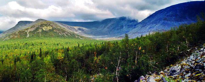
The Khibiny Mountains are considered the oldest mountains in Russia. Their age is 350 million years. The mountains are located beyond the Arctic Circle at the 67th parallel. This greatly affects their nature: there is no vegetation on the slopes, and here and there you can see bald patches of snow, regardless of the time of year. The height of the mountains is 800-900 meters, the highest point is Mount Yudychvumchorr - 1200 meters.
Khibiny mountains from space are a fascinating sight. They look like a stone flower that has opened its petals towards the northern sun. In clear weather, the mountains are visible especially clearly - sharp peaks of rocks cut the blue sky and strike fear into travelers. Local residents are afraid to approach the Khibiny Mountains in winter - they understand how much danger the icy slopes pose.
The name of the mountain was given due to the peculiarities of the local dialect. Previously, the Sami called them Umptek, and later they began to call them Hiben, which means plateau. Over time, the name stuck and remained, and local residents changed it to Khibiny.
Sights of Khibiny
We recommend that visitors to the Khibiny explore the numerous hiking trails and walk to the Blue Lakes Gorge and the Pyrrhotite Gorge. On the way you will come across a 1950 adit. An interesting hike awaits you if you chose the Molybdenum Mine as your attraction. To get there you need to take the road built in 1930. In turn, a river ford leads to it. From the mine there is an excellent view of Maly Vudyavr and Mount Poachvumchorr.
Takhtarvumchorr plateau - landscapes for lovers of surrealism. The pictures that appear to travelers are similar to those on Mars. Unusual minerals are scattered across the ground. Along the way you can come across abandoned miners' tools.
The Aku-Aku Gorge is considered a romantic place. According to Sami legends, there was a fierce struggle between the Sami and the invaders. Where Lapp blood fell, eudialyte grew, a reddish mineral. Not far from the gorge there is a waterfall and a clear, light lake.
The Kukisvumchorr plateau is another attraction of the Khibiny, famous for Lake Akademicheskoye. It is a heavenly emerald color, the water is clear and very cold. A delightful route goes along the banks of the raging Risjok River, through the South Rischorr Pass. Along the road there is a grumpy waterfall and incredibly beautiful slopes.
The sights of Apatit are interesting for both adults and children. There is a research center for conducting experiments, and the Museum of Mineralogy. The exhibition features hundreds of unique minerals. Some of them are not found in any corner of the planet.
There are many other museums in Apatity: the museum-archive of the history of the study and development of the European North, the Museum of the International Cultural Center and the art gallery “M”. Tickets to these places cost several hundred rubles and are available to everyone. For young parents with children, a visit to the children's art gallery “Kovcheg” will be interesting.
If you are lucky enough to visit Apatity in February, visit the annual exhibition “Stone Flower”. Hundreds of craftsmen offer to purchase stone products: jewelry, household items and kitchen utensils. It is impossible to imagine this splendor: you just need to see it.
In summer, Apatity is notable for its Akademgorodok and the park near the Polyarny cinema. Roses, wild roses, lilacs and other beautiful flowers grow in the park. Everything smells fragrant. Nearby is a monument to the heroes of the Great Patriotic War.
Tourism in the Khibiny Mountains begins from Kirovsk. It is located next to Lake Bolshoi Vudyavr. The Temple of the Savior of the Image of Jesus Christ Not Made by Hands is considered a significant attraction. The sanctuary is decorated with nine bronze bells. They were made especially for Kirovsk by Ural craftsmen. The decoration of the temple is rich: many icons, some streaming myrrh.
Visit local history and mining-geological museums. Visit the Museum of Literature. It is designed in the thoughtful and philosophical spirit of the writer Erofeev. Fans of his work will feel in their native element.
A must-see attraction in Kirovsk is the Polar-Alpine Botanical Garden-Institute named after. ON THE. Avrorina. This is a protected area containing hundreds of plants. Many are unique. The garden administration offers excursions to the nursery and greenhouse. It definitely won't be boring.
In winter, not far from the botanical garden there is an area called the “Snow Village”. As soon as the first snow falls, dozens of ice and snow figures are erected on its territory. They are made life-size of the character and look magical. A visit to the village will be a real holiday for children and adults.
For tourism in the Khibiny Mountains, we recommend paying attention to the Amethyst Hotel. It is located on Lenina Street, 3 in an eight-story building. This is the city center, so you can easily reach the main attractions and train stations. There is a restaurant nearby where you can have a tasty and inexpensive dinner. The rooms have comfortable and new furniture, private bathrooms.
On Pobeda Street, 29a there is a hotel Isovella, which translated from Sami means “A light breath of wind”. A special feature of the hotel is its location - half a kilometer from the city, among the forest. In the evening you will be provided with wonderful walks and fresh air. Another representative office of the hotel is the Apatit “Rus” recreation center. From its windows there is a beautiful view of Lake Imandra. There is a hall, billiards, and a gym. There is a banquet hall for celebrations.
The Sheri Hotel on Gladysheva Street, 6a is popular. There are only five rooms, but each is furnished in a homely and tasteful way. There is a TV, a wardrobe and a soft corner. Linen is provided free of charge. Picks up WI-FI.
In Guba Kislaya there is a secluded recreation center Apatit-Berloga. Beautiful log cabins, Sami milestones and a birch-fired bathhouse - what else does a tired traveler need after a long journey to the Khibiny? The houses are spacious, suitable for a company of 3-5 people. The recreation center rents out snowmobiles and turntables.
Hotels in Kirovsk
There are expensive hotels in Kirovsk. This is explained by the availability of routes through the Khibiny beauties. If the price doesn't bother you, go to the city center to the Severnaya Hotel. This is where Vladimir Vladimirovich Putin likes to relax. At the same time, the prices are not inflated: a tourist with a modest budget can stay here, paying 1,500 rubles for a room. An expensive room costs 7000. Nearby are the Aykuayvenchorr ski slopes.
The Ekkos Hotel has earned positive reviews from travelers. The fund is represented by 13 bright rooms with a total capacity of 40 people. Each room has a refrigerator, a bath or shower, and air conditioning. There is free internet. Couples with children are offered rooms with a kitchen.
You can comfortably spend your holiday in the Khibiny Mountains at the Parkovaya Hotel. It is located on the street of the same name and combines maximum comfort and a reasonable price. The rooms are furnished with fresh furniture and have free WI-FI.
The Khibiny Mountains have a unique climate. It is formed by Arctic and Atlantic winds and is changeable even in warm weather. There is a polar night, which has a significant influence on the formation of weather conditions. Very humid: rains frequently, but evaporation is weak. Coupled with sharp gusts of wind, ordinary rains turn into mountain thunderstorms.
There is no concept of “season” on the Kola Peninsula. All seasons are mixed up and last longer than expected. For example, winter is the longest - 7-8 months. All this time frosts persist, the slopes are covered with snow. It does not melt in the gorges all year round.
The ice melts at the end of spring, so the polar day begins from May 12 to July 19, which is also summer. The weather is unstable and not very warm. In September frosts begin again and winter sets in.
Summer holidays in the Khibiny Mountains will appeal primarily to climbers. However, if you are not an active tourist, do not worry. The mountains offer many easy hiking routes to enjoy the stunning nature of the north. Visit Maly Vudyavr Lake: it is located between a dense forest and mountains. A great place for a picnic and outdoor games.
Another unusual place that is worth visiting on your summer holiday is the Ganeshin Circus. It offers a gorgeous view of the granite rocks and Lake Maly Vudyavr. If you went on a hike for more than one day, choose the circus as a place to stay for the night - there are no mosquitoes and it is relatively warm.
Be sure to get to Mount Kukisvumchorr. The fast river Yuksporryok flows there - it will lead to the Shchel pass. Overcome it to reach an untouched corner of the planet - you will be amazed at how pure and majestic the mountains and lakes look. Look to the south - there you will see quarries with apatite ore and the Tulyok River.
Not far from the Umbozersky pass there is a “Beautiful” waterfall. It fully lives up to its name and is considered one of the most wonderful places in Russia. Summer holidays in the Khibiny Mountains will be remembered for a long time, and the photographs will cause aching boredom in the heart for many years to come.
Winter holidays in the Khibiny Mountains include ski resorts and exciting snowmobile excursions. Famous trails run along the slopes of the Aykuavenchorr and Kukisvumchorr mountains. At the top of Aykuavenchorr there are three complexes - “Aykuay”, “Kolasportland” and “Big Woodyavr”. The length of the tracks is more than 30 kilometers. Here you can find something to suit every taste - skiing, snowboarding or sliding down a hill on a colored bun.
Staying in Apatity? Then you go to Sparrow Mountain. It is perfect if you are a beginner or teaching children. In addition, the slope is protected from the wind, so skiing here is comfortable and warm.
Khibiny is a magical land where phones and tablets are not needed. Nature penetrates the soul, stirring up the most intimate memories. It’s easy to fall in love here or, conversely, forget yourself. The Khibiny region is also no stranger to unbridled joy - hiking in a large company will become a vivid life experience.
As you know, the Khibiny Mountains are the largest mountain range located on the Kola Peninsula. The name “Khibiny” appeared not so long ago, because before that the mountain system was called the Sami word “Umptek”. It is believed that the geological age of this rock reaches about 350 million years. The exact origin of the Khibiny is still unknown, although according to the Russian dialect of the Arkhangelsk region and the Kola Peninsula, the prevailing term is “Khiben”, which means “plateau”.
The mountains are composed of igneous rocks or nepheline syenites. The Khibiny massif has plateau-like peaks, rather steep slopes, in some places there are glaciers and snowfields. The highest point of the mountain system was Mount Yudychvumchorr, whose height reaches 1200.5 m above sea level and which drops off quite steeply in the form of inaccessible sheer cliffs.
The Khibiny mountain range is shaped more like a horseshoe, somewhat open towards the east. The characteristic relief was high, flat plateaus, as well as a complex system of especially deep valleys. Most of the valleys end in the form of global glacial cirques, which contain snow throughout the year. The inherent plateaus are flat surfaces completely covered with bare rock deposits. A huge number of minerals are found in the Khibiny Mountains, the vast majority of which were discovered at this site for the first time - which is why the Khibiny massif is also called the mineralogical natural museum. The minerals found here are of greatest importance. This place contains the world's largest deposits of apatite containing phosphorus, as well as titanium, sphene, molybdenum ores and many other rare elements, which have become a reliable base for the mining industry of the North.
As for the flora of the Khibiny Mountains, it changes more and more with increasing altitude. The slopes and foothills of the mountains, reaching a height of 350-400 m, are occupied exclusively by coniferous forests, represented by spruce and pine forests, which can most often be seen with an admixture of birch species. A little higher there is a crooked birch forest, rising even more in height by 100 m. In an even more elevated zone there are zones of crooked forest - this is the tundra, almost completely covered with small shrubs - blueberries, lingonberries, crowberries, bearberry, as well as various types of lichens. After the first frosts have passed, the leaves of all plants quickly acquire a rich, bright color, while creating an incredibly beautiful multi-colored carpet. As altitude increases along the slopes, vegetation cover becomes increasingly sparse and bare areas of rocky embankments can often be found. All the mountain peaks are almost completely without vegetation, and on the rocks and in some places there are scattered yellow, gray and green patterns of lichens that predominate in these places. The flora of the Khibiny Mountains is especially valuable, because a considerable number of representatives of local vegetation are listed in the Red Book. As for the local fauna, the terrestrial vertebrates of the mountain range are represented by 27 species of mammals, 2 species of reptiles, one species of amphibian and 123 different species of birds.
Today, the following mines operate on the territory of the Khibiny mountain range: Rasmvumchorr (Rasvumchorr plateau and Apatite Circus deposits), Kirov (Yukspor and Kukisvumchorr), Central (Rasvumchorr), as well as Eastern (Nyurkpahk and Koashva). Mining is carried out both open-pit and underground. The number of open mountain ranges is increasingly decreasing, and after some time the development of deposits will be carried out exclusively by underground methods.
For quite a long period of time, the Khibiny Mountains have been one of the most favorite holiday destinations for tourists, because this is the first alpine region in the entire Arctic in which a proper system of routes was carried out, ranging from educational to the most difficult. Even the small height of the mountains can be deceptive, because the climate peculiarities inherent in the area often create extreme conditions for the ascent process.
The Khibiny Mountains are a mountain system that has attracted researchers and nature lovers since ancient times. They are not as difficult to reach as other areas. You can get to the mountains by car. Or another option is to get to Murmansk by plane or train.
Location and terrain
The Khibiny Mountains are located between and Umbozero. They are an array consisting of plateau-like peaks. The highest point is 1201 m. This is Mount Yudychvumchorr, which is part of the Khibiny massif. The average height of the mountains is 1000 meters.
There are many traces of ancient glacial activity. Circuses and punishments talk about this. And also troughs - valleys plowed by a glacier, similar to troughs.
There are results of the activity of permafrost - kurums, the so-called stone rivers. And on the plateau there are entire stone seas.
Geological structure
The Khibiny Mountains are a crystalline structure - an intrusion. This is a solid geological body composed of rocks of igneous origin. There are only 8 such intrusions in the world. This is a horseshoe-shaped massif, mostly composed of rocks - nepheline syenites. In ancient times, there were huge volcanoes here, which cooled down and the magma crystallized. Therefore, about 800 different minerals were found here. Some of them are specific only to a given territory.
The names of modern settlements correspond to the minerals found here: Nepheline sands, Apatity, Titan. After the heavy glacial shell descended from these mountains, this territory experienced tectonic uplift. It occurred unevenly, as evidenced by the nature of the geological structures. They look like funnels, the edges of which are composed of older rocks than the center. For approximately 20 million years, the Khibiny Mountains rose 500 meters above the surrounding plains. Then there was a long break of 15 million years. Then the mountains began to grow again, this time their height doubled.
Climate
The Khibiny Mountains have climatic conditions that depend on geographic location. On the map of the North-West in the European part of Russia you can see that most of the peninsula is located beyond the Arctic Circle. Despite this fact, the climate here is much warmer than in others. The severity of the local weather is mitigated by the close location of the Barents Sea, since the North Cape warm current enters this part of the ocean. Therefore, the climate here is quite mild, and severe frosts are relatively rare.

Due to the location of the Khibiny in the Arctic, twilight reigns here for six months. In winter, daylight hours are very short and last 2-3 hours. The polar night lasts about four months - a period when the sun does not rise above the horizon. And due to its proximity to the planet’s magnetic pole, you can observe a very impressive phenomenon - the northern lights.
Summer lasts two and a half months. The highest positive temperatures are +20 in July. The average for the month is +13 degrees. The coldest period lasts during January. The average temperature of the month is -11 degrees. And the Khibiny Mountains have the most negative mark in winter -35 0 C. Photos of these places show that there are often fogs and high clouds here. This indicates the influence of cyclones on the territory. Precipitation falls mostly in the form of snow.
Flora
The vegetation cover consists of several belts. The zone of coniferous and mixed forests is located mainly at the foot of the mountains and in river valleys at low altitudes. This belt ends at an altitude of 470 meters and occupies a third of the massif. It is dominated by spruce and birch. In the forest you can find rowan, aspen and bird cherry.
Higher up begins the zone of subalpine birch forests. It stretches as a narrow strip between the belts of forest and tundra. Swimmingweed, geranium, and thistle grow here.
Next comes the mountain-tundra zone. It occupies about half of the entire area of the Khibiny Mountains. Below, shrubby vegetation is common. The berry season continues in early August. Blueberries, blueberries and cloudberries are ripening. At the beginning of autumn, the time for lingonberries comes. Above is the moss-lichen tundra. Green and sphagnum mosses predominate here. Lichens cover large boulders in rocky rivers. Many plants included in the Red Book grow here.
Toponymy of names
The Sami are considered the indigenous people in the Khibiny region. On the map of these mountains the names are entirely in the language of this people. However, their meanings are different. Since there are several dialects in the Kola Peninsula.
One of the versions of the origin of the name of the mountains is from the word “khiben” - a flat hill. The Sami conventionally divided the Khibiny mountains into two parts: Umbozero and Lavozero. The first in their language sounded like Umptek, the second - Luyavrurt.

The Sami first came up with the name of the river, and then the valley was named from it. And only then the ridges were designated. The first part of the word is a sign of an object (high, rocky). The second designated a geographical object (mountain, river, lake). For example, Lake Vudyavr. Wood - a hill covered with bushes. The root of yavr is lake. Thus, the Sami gave simple descriptions of objects. Among them is Vudyavr - a lake on a hill with bushes.
The Khibiny Mountains are a wonderful region that you just want to visit. This is a unique place where mountains, tundra, many lakes with clear water and the northern lights are combined. Khibiny is rightly called a treasury of minerals.
The Khibiny Mountains are a mountain range in the central part of the Kola Peninsula, which is predominantly a plateau with sloping steep slopes. In some places on the slopes of the mountain range there are so-called snowfields - accumulations of snow, protected from direct sunlight and winds. From the west and east, large lakes Imandra and Umbozero approach the mountains; in addition to these reservoirs, the area is rich in smaller lakes and small rivers.The formation of the modern appearance of the Khibiny, composed mainly of alkaline rocks and granitoids of Precambrian age, one of the oldest in Russia - about 2 billion years old, occurred mainly in the very recent past under the influence of glaciers. During the Ice Age, the entire surrounding area was covered with an ice shell, and in some places rocks towered above it. As the glacier advanced, leaving grooves in the rock, and melted, carrying away debris, and then returned again, a unique glacial landscape was formed, which is characteristic of the entire Kola Peninsula. The glaciers on the Khibiny reached their maximum size approximately 20 thousand years ago.
The rise of the mountain range began after the end of glaciation: the ice began to finally disappear here about 10 thousand years ago, freeing the surface from a colossal burden. The Khibiny Mountains continue to grow, and since the disappearance of the bulk of the glaciers, their height has increased by about 20 m. In general, the process of formation of the ridge is characterized by unevenness, which affects the structure of the mountains: their structure is concentric, this is manifested in the arc-shaped arrangement of various rock layers. In addition, there is a decrease in the age of the rocks from the edges to the center. The layering is due to the fact that magma entered the crevices.
One of the pioneers of the Khibiny was the Russian and Finnish geologist Wilhelm Ramsay, who studied both this mountain range and the entire Kola Peninsula as a whole.
The result of the scientist’s painstaking work, in particular, was the Khibiny map.
The first Soviet expedition to the Khibiny Mountains started on August 25, 1920. It included mineralogist Alexander Fersman, President of the Academy of Sciences Alexander Karpinsky and geologist of the Geological Committee Alexander Gerasimov. The main task facing the specialists was the search for apatites, which are also used in ferrous and non-ferrous metallurgy. This expedition marked the beginning of the study of the Khibiny for industrial needs.
In 1929, the Apatit mining and processing plant was opened in Khibiny. During the Great Patriotic War, mines, grenades and other types of explosives were produced there, but already in 1944 the enterprise returned to normal operation.
By 1960, the mining of apatite and nepheline ore was put on stream in the Khibiny region, as a result, new cities began to appear for workers to live. Back in 1931, the city of Kirovsk was rebuilt here, and in 1966, the New City grew next to it, which was later renamed Apatity. Subsequently, other villages also appeared nearby, which were named in honor of the countless values of the Khibiny, including Titan and Nepheline Sands.
Ski resort among minerals
Khibiny is located in the central part of the Kola Peninsula. These are mainly plateaus, separated by gorges, with numerous passes and cliffs. The central region of the ridge is occupied by the Kukisvumchorr and Chasnachorr plateaus. At the foot of the Khibiny are the cities of Apatity and Kirovsk.Currently, many deposits are being developed in the Khibiny Mountains, and about five hundred minerals have been explored here.
The Khibiny Mountains to this day retain enormous potential for the development of the mining industry. There are many not only underground, but also open deposits. In particular, in the Khibiny region, deposits of vermiculite and phlogopite mica have been explored, deposits of precious stones (including blue sapphire) and ceramic pegmatites are being developed. In total, about 500 different minerals were identified in the Khibiny Mountains, 110 of which are found nowhere else.
In addition to minerals, the Khibiny Mountains also store invaluable underground reserves of water, and thermal springs were also discovered at a depth of more than 1.5 km.
The large scale of mining in the Khibiny region inevitably affects the environment. The problems are associated with the large volume of associated rock extracted from the ground, and with the need to cut down forests to start work on new deposits. This is why environmentalists are currently advocating the idea of creating a national park in the Khibiny Mountains region.
Work on studying and preserving local nature began in the first half of the 20th century. In particular, the Polar-Alpine Botanical Garden was created on Mount Vudyavrchorr. It gradually presents vegetation characteristic of the local tundra, spruce-birch and alpine tundras, as well as the Arctic desert. In general, more than 400 species of plants grow on the territory of the botanical garden.
The fauna of the Khibiny Mountains is represented mainly by birds; there are less than 30 species of mammals. However, a small number of species of the latter are characteristic of the entire Kola Peninsula.
After the end of the Ice Age, the ice did not retreat from the Khibiny Mountains for a long time. However, now there are practically no traces left of the glacial formations, except for the characteristic relief. At the moment, there are only four glaciers on the Khibiny, which occupy an area of about 0.1 km 2.
Seismic activity continues in the Khibiny region. The first recorded earthquake occurred back in 1758, and the last was recorded in 1988, with the epicenter near the city of Kirovsk.
Approximately a quarter of the territory of this ridge is at risk of avalanches. In addition, the Khibiny region experiences very difficult weather conditions: sharp changes in atmospheric pressure and strong winds are characteristic. In particular, at the peaks the wind speed can reach 50 m/s. In addition, the angle of climb gradually increases, and the path is blocked by numerous boulders. The situation is also complicated by the extremely changeable weather: conditions can change several times during the day.
However, the Khibiny Mountains invariably remain popular among climbers. Over the years of exploration of this mountain range, well-trodden routes have appeared, including options not only for experienced athletes, but also for beginners. In addition, there are ski slopes here, which are concentrated mainly in the Kirovsk area.

general information
Location: Kola Peninsula.Administrative affiliation: .
Largest cities: Apatity - 57,398 people. (2015), Kirovsk - 27,250 people. (2015).
Nearest airport: Apatity airport.
Numbers
Area: 1300 km2.Highest point: Mount Yudychvumchorr (1200.6 m).
Main peaks: Chasnachorr (1188 m), Putelichorr (1111 m).
Climate and weather
Characterized by long and snowy winters and cold and short summers.However, the proximity of the Gulf Stream causes a warmer climate compared to other polar regions of Russia.
The polar night lasts 42 days.
Average January temperature: -5°C.
Average temperature in July: +14°C.
Average annual precipitation: from 600-700 mm in valleys to 1600 mm on mountain plateaus.
Economy
Industry: mining (apatite, nepheline, sphene, aegirine, feldspar, titanomagnetite).Scientific research.
Service sector: tourism.
Attractions
■ Natural: Lyavinskaya and Poutelle hills, Polar-Alpine Botanical Garden-Institute.■ Kirovsk: museum and exhibition center of JSC "Apatit", local history museum, V. Erofeev Literary Museum.
■ Apatity: museum-archive of the history of the study and development of the European North of Russia, museum of geology and mineralogy of the Geological Institute of the KSC RAS, open-air geological park, museum-apartment of academician A.V. Sidorenko.
Curious facts
■ The Polar-Alpine Botanical Garden is the northernmost botanical garden in Russia and one of three botanical gardens in the world located beyond the Arctic Circle.■ The Khibiny tundra was often called the “Skull of the Earth” in the past. Thus, scientists have noted areas where ancient rocks come to the surface, the formation of which is associated with geological processes multibillion years ago. These formations are part of the Baltic crystalline shield.
■ The writer Mikhail Prishvin, during his long journey through the European and Russian North, visited the Khibiny Mountains in 1907. One of the stories, “The Khibiny Mountains,” is dedicated to them.
■ Most of the Khibiny peaks have Sami names. There are few speakers of the Sami language - the Sami, or Lapps - left; they live mainly in the north of the Scandinavian Peninsula and on the Kola Peninsula.
Khibiny (Kild. Umptek) is the largest mountain range on the Kola Peninsula. Geological age is about 350 million years. The peaks are plateau-shaped, the slopes are steep with isolated snowfields.
However, not a single glacier was discovered in the Khibiny Mountains.
The highest point is Mount Yudychvumchorr (1200.6 m above sea level).
In the center are the Kukisvumchorr and Chasnachorr plateaus.
At the foot are the cities of Apatity and Kirovsk.
At the foot of Mount Vudyavrchorr is the Polar-Alpine Botanical Garden-Institute.

The Khibiny Mountains combine features of regional and local mountain climate. The outer slopes of the mountains experience a significant softening influence of the climate of the surrounding plains, and the microclimate of the central part of the massif is much more severe. There is snow in the mountains from October to June.
The polar night lasts 42 days. Frequent cyclones, sudden changes in atmospheric pressure. In the open spaces of the peaks, winds can blow at speeds of up to 50 m/s. From August to mid-April you can observe the northern lights.
Summer is short, in the mountains there are 60-80 days without frost. In the foothills, the period with an average daily temperature above 10 °C lasts about 70 days. Summer also sees maximum precipitation. The polar day lasts 50 days.
In the Khibiny, precipitation falls from 600-700 mm in the valleys, to 1600 mm of precipitation on the mountain plateaus. Throughout the year, precipitation is distributed almost evenly, a little more in summer, a little less in winter. In summer, about 20% of days are without precipitation with an average precipitation of 2 mm/day, in winter only 10% with an average precipitation of 1.5 mm/day. Khibiny, Khibiny Mountains 
Flora and fauna
Flora Khibiny is very valuable. A large number of species included in the “red books” of various ranks grow on the territory of the massif.
The fauna of terrestrial vertebrates of the Khibiny mountain range includes 27 species of mammals, 123 species of birds, 2 species of reptiles, 1 species of amphibian. Almost all mammals of the Murmansk region are represented here. Some of them are classified as protected or endangered.
Geology
The Khibiny alkaline massif is a large intrusive body of complex shape and composition. The age according to the helium-lead method is determined to be Carboniferous and is 290 ± 10 million years. A characteristic feature of the Khibiny massif is its circular (in plan) structure, which has a number of analogies among some other alkaline massifs. The rock complexes that make up the massif form arcs, as it were, folded into each other, open to the east, which is explained by the intrusion of magma along alternating circular and conical faults.
About 500 minerals are currently found on the territory of the Khibiny massif, dozens of which are of practical value, 110 are not found anywhere else. Such a concentration of a huge amount of minerals in a limited area has no analogues anywhere in the world. The unique geochemistry of the Khibiny massif leads to the accumulation of rare minerals and creates deposits of completely new minerals. Khibiny, Khibiny Mountains 
Rock complexes that make up the Khibiny massif:
complex of khibinites and endocontact nepheline syenites,
complex of trachytoid khibinites,
rischorrite complex,
complex of ijolite-urtites, malignites and lujavrites,
complex of medium-grained nepheline syenites,
foyait complex.
Within the Khibiny massif, unique [source not specified 558 days] mineral associations were found that are not typical for other alkaline rock massifs, including topaz and spinel. In the xenoliths of Mount Eveslogchorr there is a manifestation of blue sapphire - a gemstone of the highest category.
Long Lake, Khibiny 
Mining
Khibiny mountains.
The largest deposits of apatite-nepheline ores are located on the territory of the Khibiny massif.
The following mines are currently operating: Kirovsky (Kukisvumchorr and Yukspor deposits), Rasvumchorrsky (Apatite Circus and Rasvumchorr plateau deposits), Central (Rasvumchorr plateau), Vostochny (Koashva and Nyorkpakhk deposits) and the recently opened Oleniy Ruchey (Koashva deposit). Mining is carried out both underground and open pit. The number of open-pit mining operations is decreasing and soon the development of deposits will be carried out only by underground methods.
The main minerals mined in the Khibiny are: apatite, nepheline, sphene, aegirine, feldspar, titanomagnetite. Previously, lovchorrite was mined.
Expeditions and travelers
1840 A. F. Middendorf.
1887-1892 V. Ramsay, A. Chilman, A. Petrelius and others.
1880 N.V. Kudryavtsev.
1907 M. M. Prishvin.
1914 construction of the Murmansk railway begins.
1920 Academician A.E. Fersman discovered rare alkaline minerals.
1925-1926 A. N. Labuntsov discovered large deposits of apatite.
1930 Construction of an apatite-nepheline processing plant (ANOP-1) began on the shore of Lake Bolshoy Vudyavr.
2012 Oleniy Ruchey mining and processing complex was opened in the eastern part of Khibiny, on the shore of Lake Umbozero.
Currently, the Khibiny Mountains are popular among mountain and ski tourists, as well as climbers. To overcome them both in summer and winter, good physical preparation of the participants is required. However, most passes are non-category, or have 1-2 categories. All Khibiny passes can be divided into two types - saddles and gorges. Khibiny, Khibiny Mountains
Highest peaks:
Peaks
Height
Categorical
Yudychvumchorr 1200.6 m in winter 1A, in summer n/c -
Chasnachorr 1189 m -
Putelichorr 1111 m in winter 1A, in summer n/c -
An interesting fact is that until a certain time, Mount Chasnachorr (1189 m) was considered the highest point of the Khibiny. Although even now on the Internet there are often resources in which Chasnachorr is listed as the highest point. No less interesting is this fact: according to various sources, the height of Mount Yudychvumchorr ranges from 1200 to 1206 meters.
Mount Yudychvumchorr 
KHIBINY OBJECTS
Yudychvumchorr (Kild: “humming mountain”) is a mountain with steep walls and a flat top, located on the Kola Peninsula in the southwestern block of the Khibiny. Height 1200.6 meters. From the south and southeast, Yudychvumchorr is limited by the deep valley of the Malaya Belaya River, and from the west by the valley of the Fersman stream. It is the highest point of the European Arctic of Russia.
Yudychvumchorr is sometimes also called Mount Fersman, in honor of the Khibiny researcher, the famous Soviet geochemist and mineralogist Alexander Evgenievich Fersman.
Kukisvumchorr is a mountain range on the Kola Peninsula. The largest of those included in the Khibiny Mountains. The highest point is Mount Kukisvumchorr (1143 m above sea level). Located in the center of Khibiny. It is composed of nepheline syenites. The mountain slopes are steep, covered with forest-tundra vegetation. The peaks are flat and rocky. In the northern part there are two glaciers. The Vudyavryok River flows along the western side of the massif. The Tulyok and Kuniyok rivers originate on the massif. At the foot of the mountains there are lakes Bolshoy Vudyavr and Maly Vudyavr. Lake Akademicheskoe is located in the mountains. In the foothills there is a remote area of Kirovsk with the same name, where apatite-nepheline ores are being developed.
On the southern slope of Mount Kukisvumchorr there is a ski complex of the same name, which hosts annual freeride competitions.
On October 21, 2010, a man-made earthquake with a magnitude of 3.2 occurred in the Kukisvumchorr microdistrict. Tremors were also felt in Murmansk. The earthquake caused only minor damage to a nearby mine.
Kukisvumchorr pass 
Chasnachorr (Sami - Woodpecker Mountain) is a mountain range located in the western part of the Khibiny. The second highest mountain is 1189 m.
The mountain limits the basins of the valleys of the Meridional Stream from the east (connects with the meridional ridge of Poachvumchorr), the Kuniyok River and the Petrelius Stream from the west. In the north it is separated from Mount Indivichvumchorr by the South Chorgorr pass, and in the southwest it joins the highest plateau Yudychvumchorr. The most difficult passes of the Khibiny Mountains are located on this bridge: Fersman and Krestovy. The Chasnayok River originates in the northern cirque of the mountain. The highest point is a plateau. The mountain is bounded on the north, east and south by steep walls.

KHIBINY PASSES
South Chorgorr town, Lake Imandra 
view from Mount Kukis, great moon 
Malaya Belaya River, Northern Lights 
Lake Imandra from the Aku-Aku pass 
Fersman Pass is a pass in the Murmansk region, height - 974 m above sea level. It is located in the western part of the Khibiny between the peak of Fersman and the Yudychvumchorr plateau, connecting the valleys of the Meridional Stream and the Small White River. Named in honor of the Soviet geochemist and researcher Khibiny - Alexander Evgenievich Fersman.
Risyok River Khibiny, Khibiny Mountains 
REPORT ON HIKING AND MOUNTAIN TRIP TO KHIBINY
Report on the mountain hiking trip II class. in the Khibiny Mountains
Date: July 14 - August 2, 2006
Route book No. 177-04/3-216
Head: Olkhovskaya I.G. (Moscow)
1. Background information about the hike
Organization: GOU DDYUTE YuOUO DO Moscow, GOU Secondary School No. 1037 "Lingua".
District: Southern.
Trekking area: Kola Peninsula, Khibiny Mountains.
Type of tourism: mountain.
Hiking difficulty category: second.
Route thread: Moscow - st. Apatity - Kirovsk - PSS Base - lane. Northern Lyavochorr (n/k, 713) - lane. Vysoky (1A, 1125) - lane. Northern Rischorr (n/k, 875) - PSS Base - lane. Southern Rischorr (n/k, 895) - lane. Nameless (1A, 925) - lane. Takhtarvumchorr (1B, 1093.8) - lane. Western Petrelius (n/k, 846) - lane. Orliny (1B, 1105) - st. Khibiny - Apatity - Moscow.
Route length: 127.5 km.
Duration of the trip: from July 14 to August 2, 2006.
Duration of the active part: 12 days.
Route book No. 177-04/3-216.
Tourist opportunities of the area
In the Khibiny you can make hiking trips up to IV KS, mountain hikes up to III KS.
The passes Alyavumchorr Vostochny, Alyavumchorr, Burevestnik, Krestovy, Polnochny, Crack have a category of 2A in the summer and allow you to do this.
Khibiny and mountaineering region. Classified routes from 1B to 4B have been laid to the peaks of Takhtarvumchorr, Vudyavrchorr, Yumyechorr. The Murmansk publishing house "Sever" has published a catalog describing these routes.
Khibiny is a very popular ski area. Here you can plan routes to CS III. However, beginner ski groups must be prepared for a categorized route, have experience in cold overnight stays, and be able to operate in avalanche conditions.
Khibiny is a developing ski area. Directly from Kirovsk you can take the ski lifts and go to the ski slopes. There are hotels, and the private sector is developed. The slopes are rolled by snowcats.
Options for entering and exiting the route
The main mode of transport for access and exit is the railway, which passes through the city of Apatity and further along the western edge of Khibiny (the eastern shore of Lake Imandra). After the city of Apatity, within the Khibiny, there are stations: Khibiny, Nepheline Sands and Imandra.
We traveled to Apatity by train No. 212. Departure from Moscow at 1.17. morning from Leningradsky station, arrival in Apatity the next day at 10.16. The fare is 1047 rubles. Back on it, No. 211. Departs from Apatit at 21.25, arriving in Moscow at Leningradsky Station at 4.40 am. The fare is 1140 rubles.
By prior arrangement from Moscow by telephone at the railway station in Apatity, we were met by a ZIL 130 from the Kirov PSO and dropped off in the travel area, to Lake Goltsovoye. It cost us 2,500 rubles for a group of 14 people.
The city of Apatity is connected by bus with Kirovsk (southern part of Khibiny) and with the village of Koashva (eastern part of Khibiny).
There is an airport in Apatity that is capable of receiving planes from distant places. There are currently no regular passenger flights from Moscow.
Several bus numbers run from Apatity to Kirovsk. Of these, only one number (101) comes from the railway station. If you travel by other numbers, you need to change to route 101 or route 8 in the center of Apatity (near the Sever store). The fare is 6 rubles.
Getting from Apatity to Imandra station quickly is not easy. There are only two electric trains - Apatity-Olenegorsk (at 7 am) and Olenegorsk-Apatity (at 4 pm). As you know, there is no road there. That is why you have to leave more time for this section.
From Khibiny station you can get to Apatity by bus, which runs every day at 15.00. and at 17.00. The bus journey takes 40 minutes, the fare is 34 rubles. 80 kopecks. Also by the work train, which runs on weekdays at 17.00.
Other railway travel options: from Moscow and back there are three trains from Moscow to Murmansk. No. 15/16, 111/112, 181/182.
Information about the possibility of organizing pick-up along the route
Of course, the main possibility of organizing a delivery is connected with the PSS base. Another possibility is the MGU station, if the route passes there. You can always leave the cast simply in the stones, but for this it must be properly prepared. Those. in boxes and always in plastic bags in case of rain. Of course, we must not forget the location of the drop and better camouflage it.
We planned to place three drops in three different places. But on the way to the base, the rescuer warned us that at the moment a bear was wandering in those places and could ruin the camp. Therefore, we left only one drop-off in the rocks (under the descent from the Bezymyanny pass), and took the other two to the Kuelpor base. We decided that it was better to run the extra kilometers than to be left without food.
By prior arrangement from Moscow by phone at the railway station in Apatitikh, we were met by a ZIL 130 from the Kirov PSO and dropped off at the travel area, to Lake Goltsovoye. It cost us 2,500 rubles for a group of 14 people.
waterfalls under Marchenko peak 
3. Organization of the trip
Route selection
The group made a mountain hike II KS. The Khibiny region was chosen as the area for the trip due to the presence in the group of three inexperienced participants who joined the Edelweiss school tour section in the 2005-2006 academic year. The rest of the participants have quite a decent tourist experience: mountain I KS in the Khibiny, mountain II KS in the Sayans.
The majority of participants were in Khibiny not for the first time. Therefore, when constructing the route, passes were chosen that we had not yet been to. Many sections are planned to be traversed without a trail.
In 2004, while making a mountain hike I KS, we conducted a snow lesson under the Orliny pass (1B), but we could not go to the pass itself. Now, during the II KS campaign, we could pass the pass we liked and was uncharacteristic for the Khibiny. Also, we could afford to visit other difficult passes.
In 2005, Gromov V.V. released a classifier of passes in the Khibiny Mountains, consisting of 93 passes. In it, the Eagle Pass has another name - the Baltic Passage, the Krestovy Pass - Skalisty, it is not entirely clear where the Krutoy Pass is located (or is it the Eagle Pass?). What pass is meant by the name Vysoky? We wanted to find answers to these and other questions.
Alternate and emergency route options
Alternate options were provided:
Instead of the Vysoky pass (1A) there are the Nakhodka (1A) and Yuzh.Partomchorr (n/a) passes.
Instead of the Krutoy (1B) and Fersman (1B) passes, the Southern Chorgorr (n/k, 850) and 60 Let Oktyabrya (1B) passes.
Spare options allow you to maintain the declared category.
Emergency route options allow you to leave the area in the easiest way in the shortest time (see overview map of the hiking area). In our case, this is from the area of the Northern and Southern Lyavochorr, Northern and Southern Rischorr passes, and the Orliny pass - to the PSS base. They can help with transport and take you to Kirovsk. From Vysoky - through Northern Portomchorr to the base. From the Bezymyanny pass - to Kirovsk. From the Orliny and Fersman passes - to the Khibiny station. From Khibiny station you can take a bus or work train to Apatity. An emergency exit can be accomplished within a day.
Mount Rischorr Khibiny, Khibiny Mountains 
5. Technical description of the route
Explanations for the technical description
In the text, river banks and valley sides are referred to as orographic, unless otherwise noted. Transitions took 25 minutes each, unless further explained. MN is a place to spend the night. On simple scree slopes with a steepness of up to 200, self-belaying with an ice ax or alpenstock was used everywhere.
First walking day.
Apatity station - Kirovsk - PSS base - Lake Goltsovoye - approach to the Northern Lyavochorr pass (n/k, 713).
Overnight at an altitude of 400 m.
Elevation gain -200 m.
Height drop - 0 m
Kilometers - 4.8 km.
CHW - 40 min.
On July 15, train No. 212 Moscow - Murmansk arrived at the Apatity station at 10:00 am. We were met by 3IL 130 from the PSS base. We went to Kirovsk. In Kirovsk we stopped at Lenin Square near the Pochta stop. They gave 2 telegrams: to SYUTur and to DDYUTE. We went to the pharmacy and bought hiking boots for the participant in a sports store for 1,800 rubles. We bought bread for the first 3 days.
Then we went to the PSS base, leaving drop-off point No. 1 along the way at the descent from the Bezymyanny pass. We arrived at the Kuelporr base, checked in with the rescuers, left two drops Nos. 2 and 3. A total of 11 boxes.
We passed Lake Shchuchye and stopped on the right bank of Lake Goltsovoye beyond the confluence of the river. Lyavoyok is on the right as you go into the lake. The driver did not go any further because... There is no road along the lake. It is possible to drive the car along the sandy shore of the lake. But also quite close. Also, we were afraid to drive past the valley we needed. Therefore, we landed immediately after crossing the strait between two lakes. At 15.00 we got up for lunch.
At 17.00 we leave from lunch. We move along Lake Goltsovoye on the right bank along the way without a path along the edge of the lake (photo No. 1). We have to cross the mouth of the river. North Lyavoyok, which flows into the lake on the right along the way. The mouth consists of 4 branches, which we cross by fording. The ford is simple, ankle-deep, the width of the arms is 2-3 meters. We cross them in walking shoes. We go to the Northern Lyavochorr pass not along the bed of the Sev River. Lyavoyok, because there is no trail there. There is dense crooked forest all around. Therefore, we move further north along the lake another 1 km to the road marked on the map. As a guide to this road, you can use the bay in Lake Goltsovoye on the left along the western side of the lake, almost opposite the road. We get on the road and move along it one crossing (25 minutes), we go out to the Sev River. Lyavoyok, let's take a break. During this transition we come across three places for overnight stays. You can't stand anywhere, because... The river valley is narrow and rocky. All around there are crooked forests, mixed forest, low birches, pine trees, deep moss litter, last year's berries (lingonberries). There are no lingonberries for this year yet. Shiksha has not yet matured, but is just beginning. Blueberries are also just starting - we arrived early. We walk another 15 minutes and find a place to spend the night. These are rocky areas in the river valley; you can also put up tents directly in the forest. We decide not to miss it, because there may be no further places. And to the Northern Lyavochorr pass there are still about 3 km. At 18.30. We stop for the night. Water from the river. There is firewood in the forest.

July 16.
Second walking day.
Northern Lyavochorr Pass (n/k, 713) - valley of the Kaljok River.
Overnight at an altitude of 700 m.
Elevation gain -313m to the pass + 100 m across the ridge + 100 m to MN = 513m
Height drop - 200 m.
Kilometers - 8.4 km
CHW -2h 05 min.
Departure at 10.00. From MN we continue along the road. In fact, this road leads under the Central Lyavochorr pass (1A, 909), but before the confluence of the streams under the Northern and Central Lyavochorr passes, you can use it to approach the Northern Lyavochorr pass. Photo No. 2 shows how the spur of the Lyavoyok peak (1047.1) divides the valley: to the left - to the Northern Lyavochorr, to the right - to the Central. From MN this is one transition, i.e. 25 minutes.
After another 15 minutes we approach the foot of the spur of the Lyavoyok peak. The road goes to the right along the way, towards the Central Lyavochorr (f. No. 3) and its pass takeoff is visible. And we leave the road to the left, moving along a barely noticeable path along medium and small scree along the bottom of the valley for 10 minutes. From here there is a view of the pass saddle (photo No. 4). After another crossing we are at the pass (photo No. 5). Passage takeoff 200m long, steepness 200 - 250, fine scree. The saddle is wide, the tour is in the central part. From the pass there is a view into the valley of the Kaljok River. From the pass we go down a little, go around the peak of Lyavoyok (1047.1), leaving it on the right along the way. We traverse a slope covered with small and medium scree, with a steepness of 200. In two transitions we reach a depression in the ridge between the Lyavoyok peak on the right along the route and the peak 905 m on the left. Thus, we climbed the spur from the top of Lyavoyok. It is 100 meters higher than the North Lyavochorr pass. From it you can see that from the peak of 905.0 m there is a road to the valley of the Kaljok River.
We, traversing the slopes of Mount Lyavoyok, descend to the upper reaches of the Kaljok River. From the slopes of Lyavoyok there is a view of the upper reaches of the Kaljok valley, Mount Lyavochorr and the Southern and Central Lyavochorr passes.
An abandoned oil rig is visible below. Not far from it, closer to the water, we will camp for the night.
It's steep to go straight down. The slope is covered with small scree, length 200 m, steepness 500-550. Therefore, we traverse a little to the left and come out to the road leading from the peak of 905.0 m. We walk along it to the first water (this is Kaljok) and have a snack. From the pass to this place there are 4 treks of 25 minutes each.
We climb the left (orographically) bank of the Kaljok River along a dirt road leading to the tower. We go through one passage, during which the boys accidentally hit a stone and get a partridge for food. You have to stop for the night at the tower, as there is firewood for cooking next to it. As the next day showed, there was nowhere for such a large group to stand higher. But you can find a place for one or two tents during one more transition. We get up for the night at 17.00. Water from the river, firewood can be collected around the abandoned tower. Quite a large rocky flat area.
July 17th.
Third walking day.
Vysoky Pass (1A, 1125) - approach to the Northern Rischorr Pass (n/k, 875.)
Overnight at an altitude of 440 m.
Elevation gain - 425 m to the pass + 200 m to the ridge = 625 m.
Height drop - 625 m in length. R. Maivaltajoka+ 260 m in dol. R. North Kaskasnynyok=885 m.
Mileage -14.4 km.
Time period - 2h20 min for ascent + 2h 30 min for descent.
We left the MN from the tower at 10.00. We move along the road, but during the first 10-15 minutes. it's over. There is a river, but from time to time it goes under the rocks. Snowfields lie on one side or the other. In one trek we reach the descent from the Central Lyavochorr pass. On the moraine, under the pass, you can put up 1-2 tents - in some places there are small pebbles, water comes to the surface in some places. The moraine is composed of medium and large stones.
We pass another crossing; ahead we see the confluence of streams that give rise to the Kaljok River. It is clear that you need to go either left or right. To the left - to the top of Lyavochorr (1188.6), to the right - to the Vysoky pass (1A, 1125), that is, the South Lyavochorr pass. Orographically this name is more logical. We are going to the Vysoky pass, so we went to the right. From below, the takeoff of the pass seemed low, but long and gentle (200m, steepness 200). But after climbing it, a huge plateau of the Lyavochorr peak opens ahead (photo No. 11), along which we walked for 2 passages until a view into another valley opened up. This is the valley of a stream flowing into the river. Maivaltayok. At the pass at 13.10. 2 notes were taken: 2003, 2005. In one of them it is written that this is Southern Lyavochorr, and in the other - High.
Thus, the climb to the pass is simple. 1And he is on the other side, along which we are going down. On the descent, the slope is 300 m long, 30-350 steep, composed of medium and large scree. The stones are sharp. We descend, following the rules of movement in rock-fall-hazardous areas, self-insurance with an ice ax, and wearing helmets. The general direction of descent is left-down. There is no path. The entire slope is strewn with parts of a crashed plane. Based on the spare parts we took, we concluded that this happened in 1985 -1986. The descent took 25 minutes.
Under the pass, during the descent, there are two lakes. One, further away, can be seen immediately from the pass. Another - approximately from the middle of the pass takeoff. One thing is marked on the map. At the second, distant lake, at 1400 we have a snack.
We left from a snack at 1530. Our next pass is Northern Rischorr. The slopes of the valley are quite gentle, up to 200, covered with small scree. Therefore, we do not go down into the Maivaltayok valley, but traverse the eastern slopes of Portomchorr (1081), leaving the mountain on the right. We are moving without a path. After two crossings we reach a stream flowing from under Northern Portomchorr. We cross it over the rocks. From here its saddle is clearly visible.
Continuing to traverse the slope, we go around the city of Portomchorr from the south over two transitions. We move along a simple scree slope with a steepness of up to 200. Thus, we went around the mountain from the south.
We come to a steep descent into the valley of a stream flowing from under the South Portomchorr pass. This is the left tributary of the river. Kaskasnuyok. The steepness of the slope is about 300 - 350, the length of the section is 200 m, the elevation difference is 120 m, covered with small scree. Using self-belay with an ice ax, wearing helmets, we descend the slope to the stream along a serpentine road, cross the stream on the rocks and on the right bank at 1900 we camp for the night on a flat rocky and grassy area. No firewood, water from a stream.
July 18.
Fourth walking day.
Northern Rischorr Pass (n/k, 875) - PSS base.
Overnight at an altitude of 280 m.
Elevation gain - 435 m.
Height drop - 595 m.
Kilometers -10.8 km.
CHW - 4 hours 10 minutes.
From MN we climb the spur from the peak of 1083m in one trek (25 minutes) and descend to the river flowing from under the Umbozersky pass (n/k, 527). This is the left tributary of the Northern Kaskasnuyok. We cross it over the stones. In two transitions we cross the spur of the Rischorr peak (1017.9 m), traversing its slopes. The slopes are covered with small scree, in places overgrown with mosses and lichens. By traverse we go out into the gorge of the Northern Rischorr pass. From the right side of the gorge you can see the pass saddle of the Northern Rischorr. In 10 minutes we approach the pass takeoff. In the lower part it is a scree slope, 200-300 steep, small moving scree. We first move along it to the snowfield, then we go out onto the snowfield. It is more convenient to walk on it than on moving scree. The snowfield is 200 m long, with a steepness of 200 - 300. When moving along the snowfield, the first steps hit. The ascent to the pass from under the pass takes 20 minutes. We ascend to the pass at 12.50. We go straight to the tour. The tour is made of large stones, with a ski pole sticking out of it. We take a note from a group of teachers led by S.V. Ustinov. from DDYUTE Southern Administrative District of Moscow. They were here on July 15 of this year (i.e. three days ago) and passed it in the other direction - to Umbozero.
The Rischorra gorge is narrow and long, clogged with snow. The height of the walls - rocks of the gorge is 7 m, length is 300 m.
We pass the pass saddle and emerge from the pass gap. It's starting to rain. We descend into the Rischorra valley. Almost immediately from the pass the trail begins, which we follow. The descent into the Risjok valley takes place along a simple scree slope with a steepness of 200. We descend in two steps of 25 minutes each. and we go out to a dirt road. The forest zone begins here. We go down the road. Along the right bank of the Risjok River for 1 hour, from 14.00 to 15.00, and we come to the intersection with the road leading to the PSS base. We turn right, walk 300-400m, 10 minutes, exit to the PSS base.
At the base we are located in a house with a stove. Accommodation in rescue houses costs 120 rubles per person for one day. You can order a bathhouse. 1 hour - 300 rubles.
The Ramsay Hotel was built and operates on the territory of the PSO. But the prices are much higher.
July 20.
Fifth walking day.
PSS base - South Rischorr pass (n/k, 895) - Lake Akademicheskoye - approach to the Bezymyanny pass (1A, 925).
Overnight at an altitude of 420 m.
Elevation gain -615 m.
Height drop - 475 m.
CHW - 4 hours 35 minutes.
Because of the rain, we postpone the departure until 1200. Because of the fog, only the nearest mountains are visible. We go to the South Rischorr pass (n/k, 895) along the road familiar to us from the descent from the Northern Rischorr pass. It goes along the right bank of the river. In one hour (the backpacks are light - we took food for three days, until the next transfer) we reach the crossing point over the Risyok River, where the road forks. Turn left to Northern Rischorr, right to Southern Rischorr. We go to the right.
After one more transition (up to 1400) we approach the pass takeoff (200-300, length 250m, rock-talus) of Southern Rischorr (photo No. 21). There is a path to the pass. In 40 minutes we climb to the pass. A tour in the central part of the pass, a bench around it, two memorial plaques. It's snowing and windy. So we quickly take pictures and go downstairs.
Our next pass is Bezymyanny (1A, 925). That's why we don't go down to the river valley. Kaskasnyunyok, and by traverse we go to Lake Akademicheskoye, then we traverse the eastern and southern slopes at 905m and find ourselves in the valley of the Tulyok River.
The stated route planned to climb to a plateau above the lake. However, the weather and its forecast are bad. Visibility is limited (500 m). Therefore, we decided not to climb the plateau.
We descended into the river valley and immediately came across a path going towards the Bezymianny pass. We stood above the forest line on grassy areas next to the path. Below, 400 m, crooked forest can be seen. There is no point in going down to him, because... This is a loss of height and the grass and bushes will only make you even more wet. Because The rain didn't stop, everything around was wet. And possible firewood too. We cook dinner on the burners, water from the river. We set up the tents in tandem and cook between them, because... rain and wind. The pass is covered with fog from time to time.
21 July.
Sixth walking day.
Valley of the Tulyok River - Bezymyanny Pass (1A, 925 m) - Lake Maly Vudyavr.
Overnight at an altitude of 360 m.
Elevation gain -505 m.
Height drop - 565 m.
Mileage -12 km.
CHW -5 hours.
In the morning there is rain and strong wind. The attendants get up at 9.00. We cook in the vestibule under the awning. The food on duty is delivered to the tents.
July 22.
Seventh walking day. Midday.
Excursion to PABS - 23 km of Kirovsk - approach to the Takhtarvumchorr pass.
Overnight at an altitude of 500 m.
Elevation gain -40 m (from PABS to MN) + 140 m (approach to the pass).
Height drop - 40 m (from MN to PABS).
Kilometers - 18 km, counting 14.4 km.
CHW -3 hours 20 minutes.
July 23
Eighth walking day.
Per. Takhtarvumchorr (1B, 1093) - valley of the Malaya Belaya River.
Overnight at an altitude of 400 m.
Elevation gain -593 m.
Height drop -693 m.
Mileage -12 km.
CHW -6 hours 15 minutes
Exit from MN from the forest border at the stream crossing at 10.00. We go above the stream on the right side of the valley along the middle scree, in some places we come across large boulders. Traversing the slope. In 2 transitions, by 11.30, we approach the pass takeoff. This is a rock-talus slope with a steepness of 300 and a length of 250 m. The total length of the pass takeoff is 500-550 m. In the lower part it is a rocky-talus slope with a steepness of 300 and a length of 250 m. First we move along small and medium scree, 1 transition. We approach a snowfield 100 m long, with a steepness of 300-450. The snowfield occupies almost the entire width of the pass takeoff. As long as it is possible to walk to the right of him along the rocks, we go.
The depth of the snowfield is waist-deep and higher. And to the right of it there is no longer scree, but rocks, and wet ones at that. Therefore, we further move along the snowfield, hanging one vertical railing 40 m long. Participants wear harnesses. Attached to the railings with a gripping knot. They work in helmets and gloves. Poles with lanyards on hand, ice axes secured. There is one person at a time on the railing. The steepness of the snowfield in some places reaches 450. The rope was secured to a large stone. Deputy The leader climbs a rocky section and attaches a rope to a large stone for the group to move across the snowfield. The leader hits the steps when moving through the snowfield. Participants climb the steps using a handrail with a self-belaying grip knot.
After leaving the first snowfield, a scree area appears on the right, along which movement is possible. We move along it 15 m, bypassing the snowfield and reaching a rocky-talus area. This is where the group gathers because... The scree is quite mobile, the slope is dangerous for rockfalls. It is likely that stones will hit the lower participants who are climbing the snowfield. Therefore, we gather a group over the first snowfield. We continue moving up along small and medium scree. The length of this section is 200 m, the steepness is 300. Traces of a descent path are visible on the shallow scree, but it is inconvenient to climb it.
We go out to the second snowfield. It also takes up the entire pass takeoff from the rocks on the left to the rocks on the right. It’s easier to move along it than on the rocks, so we go out again onto the snowfield. Its steepness is 300, its length is 100m. We pass the second snowfield without railings, the first one hits the steps. Self-belaying is carried out with an alpenstock or an ice ax. The second snowfield leads to a pass saddle. It is long, as you can see from the map. This pass is also called the Dragon's Gap. The pass saddle is a fairly long gap, 400m long. The pass saddle is clogged with snow in places.
From the pass we go straight down. The pass takeoff on this side is a rocky scree slope, covered with medium, and in places small, scree. In its middle part there is a snowfield, which can easily be walked around on the right along the way. The length of the slope is 300-350m, the steepness is 300. The descent takes one transition (25 minutes). Already from the descent we saw a lake below, where we plan to stop for a snack. After 2 transitions we descend to it at 16.20. It's starting to rain. We pull up the awning. While passing through the pass, the rain started and stopped several times. After a snack, we move 3 times along the moraine along the stream on the right bank. The moraine is composed of medium-sized stones. There is no path. We go to the border of the forest and the valley of the M. Belaya River.
The descent to the river passes through crooked woods, which we cross in 10 minutes. We ford across the river. The ford is not difficult, the depth is 20-30 cm. A huge number of mosquitoes happily greet us at the river. After the crossing, we go 100 meters deeper into the forest and come out onto a very well-traveled path leading to the circus of the Western, Eastern Petrilius and Ramsay passes. We immediately meet a children's group cheerfully walking to Ramsay at 21.00. evenings. We go up 200m along the trail, find a very good place to spend the night and set up camp. There is sufficient firewood in the forest, because... This is no longer crooked forest. Water from M. Belaya. Rain again. Time 21.00.
waterfall on the Tulyok river 
July 24.
Ninth walking day.
Valley of the Malaya Belaya River - Western Petrelius Pass (n/k, 846) - valley of the Petrelius River. Radial access to the base.
Overnight at an altitude of 600m.
Elevation gain -446 m.
Height drop - 246 m.
Kilometers - 21.6 km, counting 10.8 km (to the lake).
CHV -3 hours 15 minutes (to the lake).
July 25.
Day. Return from the PSS base.
Part of the group returns from the base along a route already known to it, bringing food.
Days spent in a camp near the Eagle Pass due to bad weather conditions. Visibility from 50 to 150 m.
July 28th.
Tenth walking day.
The upper reaches of the Petrelius River - approach to the Eagle Pass (1B, 1105).
There was no overnight stay at altitude.
Elevation gain -100 m.
Height drop - 0 m.
Mileage -1.5 km.
CHW - 1 hour.
July 29.
Eleventh walking day.
Eagle Pass (1B, 1105) - valley of the Malaya Belaya River.
Overnight at an altitude of 300 m.
Elevation gain - 405m.
Height drop - 480 m.
Kilometers -9.6 km.
CHHV - ascent to the pass 3 hours 40 minutes + descent to the sites 1 hour + descent to the valley. Malaya Belaya 1 hour 20 minutes = 6 hours.
We put on systems, prepare ropes, gripping knots, carabiners, and put on crampons. There are only three pairs of cats, so they are dressed by the deputy. a leader who will go first and hang the railings, and two participants. The leader walks second along the railing and hits the steps, sometimes with boots, sometimes working with an ice ax. Participants climb the railings with a self-belay with a gripping knot, wearing mittens, and a helmet on their head.
A pass takeoff 400m long, steep 300-45?, snowy, in places rocky and scree. The entire bottom is not visible.
Along the middle scree we approach the snowfield. The scree, as if with a tongue, wedges itself into the snowfield. Its length is 100m, its steepness is 30?.
Our ropes are two 40 m each, two 30 m each. The deputy goes first. leader. This is the strongest and most experienced participant. He wears crampons, with a self-belay with an ice ax and a self-release along the railing. They are attached to the station on an ice ax.
We fasten the first rope on the rock with a loop, on the right as we go. By the way, there is already someone’s noose on it. But we hang ours.
From the snowfield we go out to the right along the path to a rocky scree area with a steepness of 35? - 40?, and gather a group. Since everyone comes up one at a time, this process takes about 30 minutes. Fog blows in from time to time. Strong wind, drizzle. There is a small patch free of snow where you can sit a group. In order not to freeze, we cover ourselves with an awning. While we are waiting, we hang a third rope 30 m long. Again with an ice axe. We don’t hang the fourth one right away, since everyone will need to gather in that place while waiting for the ropes from below. Until the last of the 14 people pass the previous railing and bring it back. And in that place on the snowfield there is nowhere to sit. There is no shelter from the piercing wind with rocks. In addition, almost everyone’s feet are already wet from the snow. Therefore, we gather the group here, after the second rope, and not after the fourth.
After the last participants arrive with ropes and ice axes, we begin the upward movement again. We pass along the already completed 3rd railings of 30 m, then 2 ropes of 40 m and another 30 m. We fasten everything with ice axes, they go in up to the head.
We find ourselves across the width, in the middle part of the snowfield. All equipment is used. On the rocks to the right you can see a place where you can gather the group again. We point a horizontal railing from a 10 m loop towards the rocks to the right and go out onto a rocky scree area ().
We walk along the rocks (steepness 30?) 70 m to a small open area and gather a group. We cover ourselves with an awning. We don’t go further up until all the participants have arrived, so as not to shower the lower participants with stones. Since the rocks are wet, the stones do not stick to them. If not for this circumstance, it would have been possible to climb even higher by 100 m. There is a grotto in the rock, a shelter in which you can gather a group. We no longer hang groups of ropes from the place of the second collection. We walk along the rocks, along the border of the snowfield, 100 m past this grotto and come out again onto the snowfield with a steepness of 20?. The first one hits the steps. We walk 70 m like this with a self-belay with an ice ax and go out to the pass saddle.
July 30.
Twelfth walking day.
Valley of the Malaya Belaya River - st. Khibiny - st. Apatity.
Overnight at an altitude of 160 m.
Elevation gain - 0 m.
Height drop - 140 m
Kilometers - 7.2 km.
CHW - 2 hours.
Get up at 10.00. At this place, where the road crosses the river from the right bank to the left, the river spills into two branches, going around the island. The Malaya Belaya River can easily be forded at this point. First one sleeve, then the other. But part of the group does not want to get their “wandering” shoes wet, so we decide to cross the river. In addition, one participant is sick. It is not advisable for him to wet his feet in cold water. They took almost everything from the patient’s backpack.
We begin organizing the crossing at 11.20. From the island to the other side. There are trees both here and there.
We cross ourselves, backpacks separately (). At 12.10 the whole group is on the other side. It takes 10 minutes to collect equipment, and at 12.20 we leave along the road to the west, to the Khibiny station.
The road goes through a mixed forest. We walk three passages of 40 minutes each and reach the first country houses of the village near the Khibiny station. Since today is Sunday, we meet mushroom pickers, from whom we learn that today it is better to leave by bus at 17.00. in Apatity. In general, it runs on Tuesdays, Thursdays, Saturdays, Sundays at 15.00 and 17.00. The fare is 34 rubles 80 kopecks. The work train runs on weekdays; it arrives in Imandra at 17.00. But it often happens to him that he is late; it can take 3 or 4 hours to travel from Imandra to Apatity.
8. Conclusions and recommendations
Selecting an area and route line
When choosing the area and hiking route, we were guided by the following considerations. The area should not be very remote and not very difficult, because... the group has three inexperienced members. At the same time, the route should have interesting passes for more experienced participants. Since the area is not new to us, we had to look for difficult passes where the main part of the group was not. Place them on the route thread, taking into account the organization of transfers. As a result, we passed little-visited passes in the Khibiny Mountains. These are Southern Lyavochorr (Vysoky (1A, 1125)), Takhtarvumchorr (1B, 1093), Orliny (1B, 1105).
We set ourselves the goal of clarifying the name and location of some passes. During the hike, we found out that the Vysoky pass (1A, 1125) is the South Lyavochorr pass. Located in the southern part of the Lyavochorr mountain massif.
The estimated location of the Krutoy Pass (1B, 1030) was photographed from both sides () and marked on the route map of the Orliny Pass (1B, 1105).
Due to bad weather conditions, we lost time waiting under the Eagle Pass and did not visit the Fersman Pass.
Crossing the Eagle Pass was the culmination of the entire trip. It turned out to be the most difficult in terms of weather conditions and from a technical point of view, but also the most interesting and memorable. The time to complete the pass can be reduced if you go through it in teams and if each participant has cats. But to Khibiny, few people take cats with them for each participant, because... Snow passes are still not typical for this area.
Interesting objects
The hiking area is known as one of the largest in the world for the extraction of apatite and other minerals, from which many useful things and objects can be made. For example, facing tiles, glasses, cups and much more that surrounds us in everyday life. And the extraction of ore in quarries itself is technologically interesting. You can learn about all this at the Mineralogical Museum in Kirovsk.
The history of the development of the area is connected with exploration work, which is reflected in the names of the passes in honor of the geologists who worked in the area. For example: Ramsay, Petrelius, Arsenyev. There is a memorial plaque at Ramsay Pass. On the road to Lake Maly Vudyavr there is a monument made of brickwork on the site of the first research station for the study of Khibiny at Moscow State University under the leadership of Academician A.E. Fersman. She continued to work even during the Great Patriotic War.
Unique is the Polar Alpine Botanical Garden in an area of 23 km. This is one of the highest botanical gardens in the world. We definitely recommend everyone to visit there. The Botanical Garden offers visitors a number of excursions: to the Tropical Greenhouse, “Introduction of Plants and Greening of Polar Cities,” “Ecological Trail, Geographers,” which introduces the altitudinal zonation of the vegetation cover of the Khibiny Mountains.
The most favorable time to visit this area is late July - early August. At this time, blueberries, blueberries, and many mushrooms ripen. And already the mosquitoes and midges have subsided.
We caught the beginning of the ripening of the berries, although if we had gone later, we would have been able to eat them only at the beginning and end of the hike, because... the rest of the time they were above the forest line.
Everyone had a mosquito net and mosquito repellent spray with them. It should be noted that there are significantly fewer mosquitoes above the forest line.
Performed by Olkhovskaya I.G.
__________________________________________________________________________________________
SOURCE OF MATERIAL AND PHOTO:
Team Nomads
http://www.khibiny.net
http://skazmurman.narod.ru/
http://www.hibiny.com
M. M. Prishvin “Khibiny Mountains”
Fersman A.E. Travels for the stone. - M.: Publishing House of the USSR Academy of Sciences, 1960.
Petition to the Minister of Natural Resources and Environment of the Russian Federation S.E. Donskoy: Prevent the resumption of the conflict in the Khibiny Mountains
Features of passing the Khibiny passes in winter
Classifier of obstacles in sports tourism. Khibiny Tundra of the Kola Peninsula. List of passes. Arsenin Pass.
"Tourist travels around the Kola Peninsula", O. Slavinsky, V. Tsarenkov, FiS Publishing House, 1965.
Mysteries of the Kola Peninsula
Wikipedia website
http://www.photosight.ru/
http://www.skitalets.ru/mountain/2007/khibiny_olkhovskaya06/


