we, of course, could not refuse the offer to stomp along the northernmost geographical point of the mainland of European territory. moreover, they promised different beauties ... beauties in the teeth, a camera on the neck, jumped into the car - we were going to the Rybachy Peninsula.
Strategic map of the area with important notes :) blue dotted line - our approximate route 
the weather in the Arctic is all so sudden. and if the unsetting sun accompanied us all the way to Teriberka, this time almost all the way passed in misty milk. almost the checkpoint and the barrier did not slip through :)) - the peninsula itself has been open for a long time, but the stern guys in uniform are interested in the purpose of the visit) 
after the barrier, the civilized road ends. cars are piling up, the guys are bleeding the wheels - they are getting ready for the delights of off-road life :) and then beauty begins.
the Titovka river and the Melnichny waterfalls cascade. 
I would love to spend more time on the waterfalls, but it was evening, and still hoo to go to the place of the overnight stay .. were limited to a couple of glances 
a five-minute rest in front of the mountain pass. 
the fog thickens. Musta-Tunturi is a mountain range that separates the middle and Rybachy peninsulas from the mainland. 
driving along the pass into the fog is still a pleasure. visibility tends to zero - I'm going there, I don't know where. 
mountain roads can be dangerous, even if they are not high mountains. 
rescue operation to retrieve a stuck tractor. they say he had been resting here since the beginning of spring) the operation ended successfully, after 2 days on the way back, they hit just the very moment when they managed to pull him onto the road. 
the fog has cleared, the pass is passed - we are on the Sredny peninsula. 
in general, Sredny and Rybachy are often called in one word - Rybachy. but in reality there are two peninsulas - one crossing the isthmus into the other. Medium in Rybachiy. 
the time on the clock is midnight, it was decided to stop here. 
after dinner (or what is the name of the meal after midnight? :), we explore the surrounding area. a hanging project of a hotel - a recreation center (according to the plan, it should already be commissioned). very nice project, I hope someday it will still work. We walked to the houses, looked - if they finish everything, it will turn out great. there are not many cozy resting places on the coast of the Northern Arctic .. 
the next day came - there is a big excursion to the Middle, but by the evening we should actually get to Rybachy. the track is expected to be difficult) 
driving along the coast. if you look very closely, you can see Norway :) 
about somewhere here :) here and sms come "welcome to Norway". Pts nice, but the connection on the phones was turned off just in case :) 
A lonely sail gleams in the blue mist of the sea ... 
subtle natural toning. I was lucky with the weather again, it seems that there is not much sun, but it is not cloudy either. 
us there! I love places where people, to put it mildly, are few) 
our little gang) 
promised to show us "two brothers". what is it, what does it look like? .. we are driving the first car: "Guys, tell me at least where to look? ... She, they say, do not miss it! you will see, you will immediately understand!)
and really .. did not miss and understood :)) 
"Two Brothers" are multi-meter stone outliers located on the coast of the Sredny peninsula. In ancient times, they served as landmarks for fishermen, and the Sami considered bizarre stone sculptures sacred, made sacrifices and pagan rituals here. 
brother is one. 
and another brother. 
there is a beautiful Sámi legend about the Noids. it says that they are not brothers either, but the groom and his betrothed. well, it doesn't matter .. the spectacle is impressive anyway) 
view from the pebble away from the brothers) 
encyclopedic information: the peninsula is a plateau that abruptly drops off to the sea. The plateau is composed of shales, sandstones and limestones. 


a few kilometers from the "Brothers" there is another interesting place - the Coast of Red Stones. or the Coast of White Stones (apparently, it depends on the weather at the moment :)) 
stones of amazing alien shapes sharpened by the okyan sea. 
yes, and indeed - the stones in the sun are red. 
and without it - white. 

Selfie-holy :) 
I was here and watched the surf a bit. The most difficult thing is to simultaneously catch a wave and a ray of the sun, which peeped out very timidly because of the clouds)) 
the panorama in a compressed form looks so-so .. I recommend watching it live :))) 
perfect place for lunch. 
I also didn’t know that there are eagles on Kola) 
to be continued...
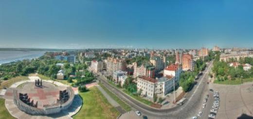
In mid-July, out of business, my colleagues and I found ourselves on a two-week business trip to Murmansk. Since they arrived in Murmansk in my car, they tried to spend their free time actively: we saw the city, repeatedly fished in the Kola Bay, twice went to Teriberka, and I also managed to visit the Rybachy Peninsula ...
One weekend I was lying on the couch of a rented apartment and decided to read information about the Rybachiy Peninsula and reviews of automobile travelers on my smartphone. The more I read, the more I got the idea of going there. Considering the bad roads and the lack of preparation for the trip, I planned to get only to the Musta-Tunturi pass, walk there along the rocks, to the places of battles and return back. It took no more than half an hour to get ready, in fact there were no fees, I just drank coffee, smoked a cigarette and drove off. I planned to refuel on the way, go to the store for some food and water, but somehow I slipped through all the stores and, having refueled, went with a bottle with about 50 ml of water in the back seat. This attitude towards food was a big mistake, I realized that quickly. All two weeks of our business trip there was a heat of about 30C, which, coupled with high humidity, created a terrible stuffiness. The day of the trip was no exception and I wanted to drink already 50 kilometers from Murmansk.
The route from Murmansk to the Titovka checkpoint is excellent, everyone checks the documents at the checkpoint. As I understand it, the main requirement for free travel is the citizenship of the Russian Federation. After the checkpoint, turn right onto the dirt road, in fact, from this moment the adventure begins. The road along the Titovka River is all in pits and bumps, like the rest of the way, there is probably no point in describing the quality of the “coverage”, because there is no such coverage, there are a lot of reviews on the Internet, I can only say that it is quite possible to drive if carefully.

The road along the river is replete with scenic views and I have repeatedly stopped to admire and take a picture. Unfortunately, the photo does not convey the height.

After some time, the road goes to the left of the river and, meandering, rises higher and higher to the pass. Not the Caucasus, of course, but the rocky northern hills have their own special beauty, it's not just that people who have visited these places once come here again and again.

While driving along Titovka, I was very thirsty, there was a feeling that the palate was stuck together and cracked, I definitely decided that I would reach the pass and turn back. At some point, while bypassing the next pit, it seemed to me that a bottle was lying in the road dust, I drove it, looked in the mirror - it seemed like a bottle really. He stopped, approached and was stunned, a half-liter sealed bottle of “Holy Spring” water lay in the road dust. At that moment it was a sign for me, a sign that I had to go further, beyond the pass. And indeed, it was worth getting drunk as the mood immediately lifted and the strength and desire to go further appeared. After that I quickly reached the Musta-Tunturi pass.

Unfortunately, I was not prepared for this trip and did not have a plan, any points of interest, therefore, stopping at the pass, I just walked along the surrounding rocks. Climbed to the top in search of traces of war. Found.

 Echo of war
 After the pass, the road began to descend, also replete with views worthy of the artist's brush. I have stopped and admired many times. Thus I got to the Sredny peninsula. I did not like the way through the Sredny peninsula: a dead road, shaking the car from side to side of the pit, a speed of 10 km / h, a monotonous landscape on the left and the Bolshaya Motka lip on the right. From time to time on the coast of the bay there were parking lots of visiting fishermen and tourists. Sights of the Middle - monuments to Soviet soldiers who fell in battle. In my opinion, you need to go to the Srednyaya in order to touch the history of the Great Patriotic War, not passing through as I did, but thoughtfully, knowing specific points. It was in these places and about the events that took place in these places that Konstantin Simonov wrote the poem "The Son of an Artilleryman".
 Reminded the "Son of an artilleryman" K. Simonov


 The Middle Peninsula is a war
 I drove the middle one along the eastern bank and ended up on the isthmus with Rybachy. For myself, I set the task of getting to Cape Nemetsky, to the northernmost point of the peninsula, which is also the northernmost point of the European part of continental Russia. In one of the reviews I read that it is better to get there along the western coast of Rybachy, and I did just that. Having passed the isthmus, I immediately turned left onto the road leading to Cape Nemetsky, leaving the abandoned village of Bolshoye Ozerko on the right. The Rybachy Peninsula is no longer as monotonous as the Sredniy Peninsula, at least it seemed to me so. I drove towards the sun, sometimes it made it difficult to go around stones and pits, but the views were simply fantastic.


The road on the western side of Rybachye is better than on the eastern side of the Srednee, the speed is also 10-15 km / h, but somehow more varied than chtoli. The car chatters less from side to side, but there are many large stones and fords. If you take your time, then completely passing through almost any car.

Perhaps, the beach left the strongest impression on me, before reaching about one kilometer to the Worm Creek. Dark gray sand, as transparent as an angel's tear, seawater in the rays of the setting sun, calm and warm evening ... I didn't swim right away, I decided to cheer up on the way back, but, looking ahead, I’ll say that I didn’t succeed, because the low tide had been pushed back by that time water about 150 meters and the view of the beach was no longer so fabulous. The photo cannot convey, it must be seen personally, it is worth it!

It was only a stone's throw from this place to Cape Nemetsky. Having strayed a little along the roads of the tundra in unsuccessful attempts to bypass the military unit standing on the way, I got to my destination.

Below is a short video sketch that I blinded from videos shot on a mobile phone. I shot with one hand, the other held the steering wheel, respectively, the areas that had to be overcome while holding the steering wheel with both hands were left behind the scenes.
At the final point, I stayed no more than an hour, walked, admired the sea and drove back. The return trip followed the same route. Left the house at about 14-30, came back about 9-30.
While driving along Rybachy, I met a car of French travelers. I didn't notice the people nearby, so I just drove by. Having already returned to St. Petersburg, I went to the site indicated on the board of their car and read information about them, about the car and their travels. Read it, it is interesting to look at our country through the eyes of foreigners who have seen it not only at football stadiums and bars in big cities.

P.S. I consider it my duty to ask you, friends, do not litter, please. The tundra will not take anything, everything that you left will lie for decades if not centuries. The soil layer is very small, do not tear it with tire treads, it will heal for a very long time, there are roads.
P.P.S. A week ago I was sure that I no longer traveled to Rybachy by car, but now I have thoughts about proper preparation and how to plan the route. I will go, I will definitely go, but not in a hurry, with fishing and spending the night in a tent ...
Why do we love the north so much? Because the beauty of these places can not only be seen, but lived! Test yourself, your courage, your endurance and resilience. Overcoming the trials of the chosen path is much more expensive than the gentle southern seas and beaches. Returning from the north, the trail of power does not fade in the sight.
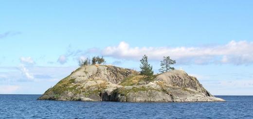
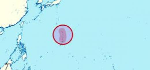
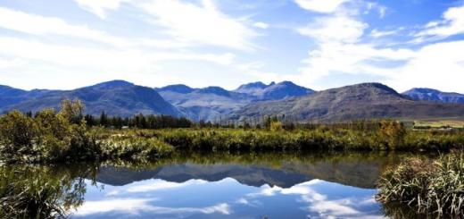
The Rybachiy Peninsula is located in the north-west of the Murmansk region, it is a real "end of the earth". The plateau drops abruptly to the Arctic Ocean with sheer black cliffs. Off the coast of Rybachye, the waters do not freeze all year round thanks to the warm Nord Cape Current. That is why at various times it was a refuge for the Vikings, the land of the Sami and even a closed military base. Today the Rybachy Peninsula is famous for the largest bird colonies in the northern part of Europe.
The raging Barents Sea, dank rain and roaring wind - these are Rybachy Lands - the extreme point of the European part of Russia, further only the Arctic Ocean and the North Pole. In this world there are no trees and countless stones. The weather here changes ten times a day, and the sun does not set over the horizon ....
Our route will pass through the Rybachiy natural park. We will see the splendor of the blooming tundra, picturesque bays and coves, sandy beaches, waterfalls. We will hear the roar of bird markets. Perhaps we will come across herds of reindeer on our way.
There are crabs in the sea here, and the streams are rich in salmon. Travelers come to the peninsula for a variety of reasons. Someone wants to admire the northern nature.
Someone wants to see with their own eyes the places of ancient settlements and visit modern reindeer herding camps. Many are also interested in the monuments associated with the military past of Rybachy and its former military towns. The traces of war can be found everywhere here. Between the stones there are rusty fragments of mines and shells, remnants of Soviet and German barbed wire, shells from grenades, broken weapons and cartridges for 1200 days and nights, the defense of Srednee and Rybachy continued.
Number of participants: from 6 to 10 people
Age limit: from 14 years old accompanied by parents.
Features of the hike: the backpacks are full from the first day - there will be no food tossed, inaccessibility when leaving the route outside the plan.
Activity
The threads of the route
Murmansk - Sredny peninsula - Volokovaya bay
The purpose of this day is to reach Cape "Cow"
Pos. Vaida-Guba - Cape "German"
We go to the cape "Skarbeevsky"
The center of the peninsula is Mount Perevalnaya
Mountain stream Lonsky
Musta Tunturi ridge
Departure to the city of Murmansk
Daily route
On the ordered off-road vehicles, the group moves to the village of Novaya Titovka, where they inspect the waterfall on the Titovka River and have lunch. Then, through the Musta Tunturi ridge and the Sredny peninsula, we go to the beginning of the hiking route. Upon arrival at the starting point of the route - Volokovaya Bay, we distribute public equipment and food in our backpacks and go to the place of the first overnight stay about 10 km along the coastline.
The purpose of this day is to reach Cape Koroviy. We will see the fortifications left over from the times of the Great Patriotic War. Trenches carved into rocks, underground structures, firing points. We will go up to the tundra lakes, we will see bird colonies on the rocks. The length of the second day is about 15 km.
We leave the coastline towards the village of Vaida - Guba, our way lies to Cape German. On the way, we will pass several German bunkers (long-term firing points), several meters high, built of natural stone. These structures are well preserved, they are not destroyed and can be viewed both outside and inside. Then we will pass by the military town and go to Cape German.
T We will see the northernmost lighthouse of the continental European part of Russia, an abandoned border post and admire the ocean surf. We go past the operating meteorological station to the bay, where we set up a camp.
At the beginning of the day we will pass by the graves of British pilots who died defending the Allied caravans. Then we cross the river and along the road we move to Cape Kekursky. Eternity is felt here, and only here any person feels all the power of nature.
Tundra vegetation, a peculiar landscape, green and white lichens, moss, reindeer lichen create unique landscapes in combination with rocks and the sea.
We are going to Cape Skarbeevsky. Again we see reminders of the battles of the Great Patriotic War, several times we go out to the sea, where we admire the bird colonies on the steep cliffs.
The abandoned military town, through which our path lies, resembles the scenery of a Hollywood horror film. Our stop on this day is in a picturesque place under the rocks on the seashore. Passed 16 km.
The route lies in the center of the Rybachy peninsula to the Perevalnoy mountain. The sea will quickly disappear from view and the endless expanses of the polar tundra will stretch out in front of us. Mosses, lichens, stones, mysterious seids and abandoned checkpoints will accompany us all day.
The reindeer herds grazing here are evidenced by antlers along the way. Parking on the bank of the purest tundra lake.
We descend from the Perevalnaya mountain along the picturesque canyon carved into the rocks by the turbulent mountain stream Lonskoy. We leave to the isthmus between the Rybachy and Sredny peninsulas. We will stop at an equipped parking lot next to the obelisk dedicated to the authors of the song "Farewell to the rocky mountains ..."
Along the coast of the Bolshaya Motka Bay we walk towards the Musta Tunturi ridge. On this day we will visit a museum dedicated to the defense of the peninsula from German invaders. Camping in the foothills of Musta Tunturi. We have covered about 20 km. Saying goodbye to rocky mountains, as it is sung in a Soviet song by Evgeny Zharkovsky (music) and Evgeny Bukin (text). The poems set to music were written by the poet on the Rybachy Peninsula - the only place in which the Nazis failed to cross the border of the Soviet Union.
Goodbye rocky mountains
The Fatherland is calling to feat!
We went out to sea
On a harsh and long hike.
And the waves moan and cry
And splash aboard the ship ...
Melted in the distant fog Rybachiy,
Our dear land.
My ship rocks stubbornly
Steep sea wave
Picks up and drops again
She is into a boiling abyss.
I won't be back soon,
But enough fire for the battle.
I know, friends, that I cannot live without the sea,
Like the sea is dead without me.
Departure to the city of Murmansk. Tickets can be taken after 20.00
I am sure that all of you, or almost all of you, have heard about this place at least once, but perhaps did not attach any importance to it. Remember the line from the song "Rybachy melted in the distant fog ..."? So this is what they say about him - about Rybachy, a peninsula covered with eternal glory, located in the very north of the European part of Russia
I have been to the Kola Peninsula many times. But all these trips took place in autumn, winter or spring. It was impossible to go there in the summer. But - I wanted to. And so that not just in summer, but necessarily on a polar day, when the sun does not sink below the horizon. And so the trip planned a few months ago seems to be taking shape - and trusted friends are ready to join the company, and there is a suitable car, and the boss does not mind. Let's go! Our goal is the Rybachiy Peninsula.

The Rybachy Peninsula is the northernmost part of European Russia. This is a border area, therefore, to visit it, you need to issue passes at the Murmansk border guard detachment or at the FSB Directorate for the Murmansk region - the procedure is simple, but it can take up to a month of waiting.
TITLE
We got out of Murmansk only in the late afternoon - purchasing food, fuel, packing luggage and cans took almost half a day. We flew about a hundred kilometers on the asphalt and behind the border control post, crossing the Titovka River over the bridge, turned off the road to the right - the journey began! There are four of us - residents of Murmansk Vladimir Kondratyev, Alexander and Evgeny Zarodovs (father and son), as well as the author of these notes. Transport units - prepared for the trophy "UAZ" on "collective farm" bridges and a 500-cc ATV Polaris.
We are moving along Titovka. The history of the name of this river and the bay of the same name in Motovsky Bay dates back to the 16th century, however, then it was called Kitovka because of the massive release of whales on land. In ancient times, Sredny and Rybachy were islands and there was a "whale crossing" between them and the mainland. Over time, the land rose, and the age-old instincts of the animals remained.

The exact purpose of these seid stones in Sámi culture is still not clear. Either they served as landmarks in the desert tundra, or were used as religious attributes
Soon we stopped on the shore for a parking lot. We had a snack, admired the completely shameless ducks stealing bread from us, and drove on - there is nothing to waste precious time sleeping. It's light, it's a polar day!
PASS
The only road from the Big Land to Rybachy was built by the monks of the Pechenga Monastery for their horse carts. Then, after the Soviet sappers, in 1940, the first tank passed through it. During the war, it was occupied by the Germans - until now, everywhere around the fortifications and barbed wire. And on the left and right under the slopes are the remains of equipment, serving as a sobering factor for any driver. The road is tricky - twists and turns, then rises, then descends from the hill to the hill. I can imagine how hard it is here in winter in ice or snowstorm. It is not for nothing, probably, since the wartime, the stream before the rise is called Piany - here it was supposed to take a glass for good luck, and on the descent Sober - in order to drink cold water and take a break, wiping sweat from his forehead ... Around the amazing beauty of the northern landscapes with saucers of lakes, looking into the sky between the hills covered with soft moss and reflected in the water in some unrealistic green color. True, barely descending from the pass, we found ourselves under low dense clouds and a small, sluggish rain that subsequently accompanied us throughout the trip.
HISTORY LESSONS
We go around Motovsky Bay. To the east goes the legendary Musta-Tunturi - a four-kilometer ridge, the only section where German troops could not cross our land border. From June 29, 1941 until the end of the war, the front line here remained unchanged! But the names of all the defenders of Musta-Tunturi are still unknown. Every year, search engines recover and reburial their remains. And here to the right of the road is the camp of one of these teams. Despite the early morning, the attendants are on their feet, water in the cauldron gurgles over the fire. They invite you to sit down, treat you to tea, show your yesterday's find - a military-style flask with the scrawled name of a soldier. We meet the leaders of the group - Alexander and Ksenia. They are from Nikel, they have been working with schoolchildren here for several years already. The city administration supports - allocates tents, equipment. Yes, such history lessons will be remembered by the children for the rest of their lives!
STRICTLY TO THE NORTH
We skip Bolshoye Ozerko - a former garrison of anti-aircraft gunners, almost a city. In 1959, an air defense regiment with a missile system was transferred here from Tallinn, the same one from which a U-2 spy plane was shot down near Sverdlovsk a year later. And in the fall of 1994, the last residents left the village.
The vector of our further route points strictly to the north along the Bolshaya Volokovaya Bay. We drive along the coast, breathing in the real arctic wind at the stops. Even inclement weather does not spoil the joyful mood from the anticipation of meeting the peak point of the hike. And that's all, we have arrived! Vaydaguba, Cape German - further only the Arctic Ocean and the North Pole! Historians believe that people have lived here since the Stone Age. In the 16th century, merchant ships moored on Vaida (translated from Finnish as “change”), and trade was conducted. German is usually interpreted as "foreign". It seems that everything is mixed on this small piece: the ruins of an old pier and a monument to the defenders of the Fatherland, a Sami well and a completely modern meteorological station, stones with mysterious signs and ... a payphone operating autonomously on solar batteries.
DESERT SHORE
We collect water from an ancient well into an eggplant and head to Cape Skorbeevsky. Another legacy of the Cold War, another abandoned garrison. An eerie sight ...
We spend the night near the waterfall on Zubovka. It’s hard to believe that before these lands were so populated that the Dutch traveler, circling the Fishing Sea in 1594, seemed like one big city - there were so many buildings on the coast.
SECRET PLANS
It's time to reveal a little secret here. In addition to the usual desire to visit Rybachye, I had one more goal. Now that the "secrecy label has been removed" and the system for issuing passes to the border zone has been worked out, this summer is a real pilgrimage here. Jeepers, motorcyclists, cyclists, pedestrians ... But almost everyone travels along the same route in the central and northwestern parts of the peninsula. There are even firms specializing in off-road tourism, taking customers to pre-determined points, almost like along the Golden Circle, only with planned adventures in the form of fords and destroyed bridges. But nowhere did I find any mention of their visit to the eastern part of Rybachy. Even in Google Earth, this area is hidden for some reason by a veil of "unreadability". So let it be “our little end of the Earth”!

The roads in the tundra are unpredictable. It is unlikely that this vehicle will ever drive - its destiny is to become the prey of "metal hunters"
BPM
Leaving Zubovskaya Bay, we rush east, towards Tsyp-Navolok, along the rocky coast of the sea. After a couple of kilometers, we see flat sandy surfaces and the remains of many fortifications - during the war there was an alternate airfield here. And soon we find ourselves at BPM. This abbreviation is deciphered both as "Let's drink, guys," Moskovskaya ", and as" The patrimony of fishermen-meteorologists ", and as" Here are the ruins of a lighthouse. " The latest version is now the most correct - since 1953 there has been a fan-shaped radio beacon (BPM). Warships and cargo ships were guided by the signals they sent. A kind of analogue of the modern GPS system. In 1979, the outdated design of the lighthouse was replaced by a new one, but soon nobody needed it. From the former genius of human thought, in addition to the ruins of a two-story building, auxiliary and outbuildings, several 75-meter towers remained, placed for almost five kilometers along the sea.
CHICK-NAVOLOK
We entered Tsyp-Navolok after midnight. As it should be at this time of day, normal people were already asleep. We stopped in the center of the village near the lighthouse and looked around. Nobody. Only a couple of dogs are running around the car and begging, barking softly. We notice that a door opens in a nearby house and a figure of a young guy in a shirt and camouflage pants appears on the threshold. The building is located behind a low fence and a gate with a star. Come on, say hello. It is difficult to talk, because the cold, almost icy wind almost knocks you off your feet. Visitors are rare here, so the conversation is quite official: "Who are they, where from, why, are there passes to the restricted area?" We are at a military facility where civilians are not supposed to be. Zhenya jokingly inquires about the presence of a shop or some kind of stall in the village, which immediately relieves the tense situation - we are invited to the house to drink tea. I have never eaten such delicious bread that sailors bake in Tsyp-Navolok! Better than any croissants! Andrey is a contract midshipman, has been serving here for several years. He grumbles that they pay little, but he is not going to leave yet: “I am at home here, and who will teach these young people? Everything depends on the midshipmen. " Although himself at most 27 years old, no more. And the philosopher: “What is there to do here in winter besides work? Here I am writing poetry out of boredom - last year I filled up the whole notebook! " And after tea, he gives us a real apartment for the night with six soldiers' beds almost side by side and a stove.

VISITING MICHALYCH
The usual drizzle is pouring from the sky, and sleeping under a warm roof, and not in a wet tent, is the height of bliss. Therefore, the morning begins closer to lunchtime and ... with another check - it was the midshipman who dropped in and said that we should show ourselves with the documents at the outpost. The border guards in these parts have all the functions of power - from the primary ones to protect the borders to the police and "fish control" ones. While we were washing and getting ready, the head of the garrison himself visited us. A serious mustachioed officer meticulously examined the papers, but after looking at the "business card" - a magazine with material about our March trip to Cape Svyatoy Nos, his eyes grew kinder and the tips of his mustache crawled up - everything is fine, your own! It's time to sit down at the table together, because besides acquaintance there is one more reason - the most important, perhaps, in this situation - today is the Day of the Navy! After a small buffet table, Andrei Mikhailovich proudly showed his farm. It turns out that behind the shabby facade of the outwardly unprepossessing barracks, there is a completely modern building with all the amenities and renovation. There is a bathhouse and a la swimming pool on the street. It is difficult to imagine how hard it was all built and delivered along the “roads” on which the military “Ural” “strips” three wheels per trip, and the same BPM masts serve as landmarks in winter. But nevertheless, people live and work. On the territory of the village there is a meteorological station, founded already in 1921, an operating lighthouse, from which we have an amazing view of the stormy Barents Sea, Anikiev Island (oh, the weather would be better!) And the deserted shores for many, many kilometers around. But even at the beginning of the last century, there was a fishing trading post of the Savin brothers, the largest buyers of fish in Murman, there were houses of colonists, a church and even a hospital of the Red Cross.
STONE CHRONICLES
Meteorological conditions did not allow us to get to Anikievsky island. Here is what is written about him in the “Guide to the Russian North”, published in 1898: “During the stopping of the steamer in Tsyp-Navolok, it is interesting to visit the nearby Anikeev island, one of the slabs of which is a stone chronicle of Murman. It is all covered carefully and beautifully ... with the carved names of Danish, German and Dutch skippers who came to Murman for fish in the 16th, 17th and 18th centuries. Especially beautiful are the inscriptions: Berent Gundersen 1595, 1596, 1597, 1610, 1611, 1615 blef jeg frataget skif (“the ship was taken away from me”). Below, under the inscription, a warrior is depicted ... "And even further:" The Russian inscription, carved in curly writing, is beautiful and interesting: Leta 7158 (according to the new chronology it is 1650 - Ed. Note) Grishka Dudin grieved. " And the expedition of M. Oresheta in 1995 found an even earlier Pomor autograph: "There was Shuerechanin Vasily Malashov in 1630".
ON THE WAY RETURN
Almost a day spent in Tsyp-Navolok flew by unnoticed. In two days we definitely had to return to Murmansk. We say goodbye to the hospitable hosts and, as usual, at night, we start. Although what kind of night it is, rather a slight twilight.
If you look at the map, then there are several roads leading to Ozerk, Rybachy's junction. We choose the shortest, but, as it turns out later, the most difficult - "Zubovsky tract". He walks through the mountains among the tundra swamps flooded by many days of rains. Puddles, often as deep as the hood of an elevated "UAZ" on 35 wheels, come across every 50-100 meters. And stones, stones, stones! The speed of advance is about 3-5 km / h. Sometimes it's even easier to ride a quad, as you can go around obstacles along the edge, but the wind and rain make it a very difficult walk.
STONE GREATS
After 12 hours of non-stop travel, the loop along Rybachy closed, and we descended to Sredny. Now the direction of movement is counterclockwise. From Cape Zemlyanoy we drive along the western coast along a long 30-meter cliff, made of the finest shale plates, through which many small springs break through. The famous "Two Brothers" are gigantic outliers. There is some kind of mysticism here - it is not without reason that the Sami have since ancient times considered the Pummanki mountain to be the habitat of sorcerers (noids). According to legend, two of them - brothers Noyd-Ukko and Noyd-Akka - were punished for their atrocities and turned into these stone statues.

38 STARS
A little further, on the high bank, we meet a practically untouched coastal battery of the 1950s (judging by the nameplate on the gun, 1946). Multilevel system of moves, lubricated mechanisms. During the war, the 221st battery was also based here, which destroyed a German minesweeper on June 22, 1941 and thereby opened the combat account of the USSR Navy. The barrel from one of her guns with 38 stars (according to the number of enemy ships sunk) is now in the ship's cemetery four kilometers from this place.
GLORY TO THE HEROES!
We break the last night on this trip on the outskirts of Sredne, on the bank of the river under the Musta-Tunturi ridge. Sanya Zarodov tells how, as a schoolboy, he participated in the installation of the first obelisk on it. I carried sand up in a backpack for the foundation of the monument. Suddenly our camp is illuminated by the sun peeking out of the clouds - in a week we have already lost the habit of it. We look at the lightened mountains and somehow automatically begin to discuss the route of our next trip to the North. Harsh beauty, the attraction of the North, the end of the Earth - seemingly banal phrases, but ... oddly enough, very honest and appropriate here.

"Two brothers", who were worshiped and feared by the Sami, considering them petrified evil sorcerers. Now at the base of the northern outlier, a geocache cache is hidden.