At one time, the revered robusts stated that they closed the book of discovery in mountaineering - there was nothing more to do, they said. But the first car was very far from the high-speed machines that we manage today. The legends of the mountaineering choose the way, now there is a difficult task before the new generation: to go through more complex routes, or find other vertices.
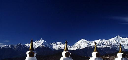
Mianzimu (6054 m), Tibet, Sacred Mountain, there were no climbers. Photo Janne Corax.
One of those who are interested in is Simone Moro, he, by the way,. A few years ago, Simone after a series of research tried to climb Batura II, the peak, which was told that this is the highest of not yet conquered vertices. Moro could not reach the top - so this mountain still throws the climbers a challenge, as well as a number of other vertices, which still did not go the leg of a person.
But what are these mountains, by what criteria to choose them? The climber, researcher and EmplorarsWeb Janne Corax employee made up a list of six top untouched vertices, and added other interesting objects to him.
Happiness to be first
Janne Corax for ExplorersWebEat vertices are always very attractive. Achieve the highest point on which no one has ever been - a special pleasure for the climbers. In 1950, Erzog and Lyashenal rose to Annapurna - the first eight-year-old, who rose people - thereby opening the "hunt" on 13 other giants. The last panel of Shisha Pangma under the legs of the Chinese team, 14 years later.
Now the climbers supervisors turned their thoughts to slightly lower targets.
Namche Barwa, 7782 m, difficult to climbing mountains with extreme relief and eternally bad weather conditions, reflected attempts to climb, until in 1992, the Japanese team failed to reach the vertex. Also, the climbers were interested in the second vertices of eight-thousandnants, and they surrendered one after another - the latter was Lhotze average, 8414 m, for which a strong Russian team rose in 2001.

MEILI ridge, view from Tibetan temple. Mianzimu on the left, Meili Feng is the highest peak on the right. Photo Janne Corax.
What's next?
Now the question is which tops from still not passed the most promising?
To answer it, you must first determine the selection criteria. Two of them are obvious: the mountain must be very high and uncompressed. The third criterion is just the problem and causes a lot of debates:
Real Mountains / Gendarms on the Ridge
Sometimes it is really a problem - to distinguish between the big gendarm on the crest and the real vertex.
For example, many believe that the greatest difference in height between the vertex of the Middle and the lowest point of the jumper, which connects it with a higher vertex - is actually a very small value.
Unfortunately, there is no absolute standard, and some are used as a measure of a relative difference of 7%, while others are 400 m. If we take into account the 500-meter limit as a compromise, then the list we need will look like this.
Six of the highest virgin peaks
Gangkar Punsum.7570 m - the vertex is located in Bhutan, in the list of the highest mountain peaks under number 40, and without a doubt it is "number 1" in our list. An educated person guesses that under this number the mountain will still remain. In the mid-80s, they tried to climb on it, but all expeditions were not returned to Solono Bread. In 1994, the vertices for climbing were partially closed in Bhutan. And in 2003 the government generally decided to prohibit all types of Lazagany. The reason for such actions lies in the field of understanding of local beliefs and traditions.
"Number 2" in our list - SASER KANGRI II EAST, 7518 m. The mountain is located in Indian Kashmir and never previously interested in the waters (at least expeditions it was not). The third top of the top of the array was sealed twice. Permit on climbing in the area is difficult, but you can. To the main vertex, the height of 7672 m The leg of a person stepped in 1973.
Kabru North., 7394 m - the highest point of the Kabru array, which is essentially a subgroup of the Cranichangi massif, is still not conquered. Surprisingly, her lower southern peak fell back in 1935. The remarkable climb committed Konrad Cook, who rose to the top of the solo, at 18 years old. It was a record for his age.
At Kabru North in 2004, the Serbs team was trying to climb, but the avalanches forced them to retreat.
Labuche Kang is a little-known vertex group in Tibet. The main vertex is conquered in 1987 by the Japanese team. Eastern - Labuche Kang III - Approximately 7250 m high and still waiting for their first spells.

Impressive South Wall Karjiang - whose hardening slopes and complex faces reflect all the attempts of the climbers. Photo from the archive Dutch Karjiang 2001 Expedition.
Karjiang, 7221 m - is also located in Tibet. A couple of times they tried to climb on her, but no one managed to still stand on her hard-to-reach top. Extreme avalanche danger and high technical complexity have yet made attempts to climb fruitless.
"Number 6" in our list - Tongshanjiabu., 7207 m. Roses on the Tibetan / Buttan border. Koreans who rose to the neighboring Shimokangri (7204 m) mentioned this vertex in the report on the expedition and published a photo in Japanese Alpine News - so far this is the only information about this grief.
Statements and Crivotian
I have to note that the six above tops will give odds to the rest in the dispute, if it comes to steepness and first criteria - untouched by climbers. However, there is always a fuss and statements on the world-consumption scene. Wherever you go, local or climbers will shown you on the mountain and say: "Look here! No one has risen on it! "
At another level, famous climbers sometimes declare their expedition "the highest of still unacted vertices." The last time I heard about the like when in 2004 Moro & Ogwyn - Italian-American Two went to Batura II. A 7762 meter height giant in Pakistani Karakorum was, according to them (and "scientific sources"), the highest vertices that a person did not rise. If you consider gendarme on the crest with a difference of 100 m of height between his "vertex" and the main mountain, then this statement, of course, contains the share of truth, however: there are other high points on the ridges, and some of the koi is higher than Batura II ... *
Untouched celebrities

Pilgrims strive for Mt. Kailash every year. They bypass the mountain around with prayers, but never step on its slopes. Climbing is strictly prohibited. Photo Project Himalaya.
The most famous from the uncompressed vertices below those that we called. Kailash. In Western Tibet, the mountain is sacred for Hindus, Buddhists and followers of the Bön religion. Never arrived at her top, and Permites are not issued, as this place is a shrine.
Whole ridge Meili., known as Kawa Korpo, in the extreme northeast of Yunnan Province in China is also considered sacred for local residents. Some of the vertices of the ridge were trying to go up at the time when permitis on ascents were issued. At the moment, these mountaineers are closed.
Mianzimu. The MEILI Ridge is considered one of the most beautiful peaks of the world, as well as Kailash.
* In one of the interviews, when Simone was asked why he called Batura II of the highest top of the vertices, which man did not rise, he referred to the Wolfgang Hichel expert data and invited interested in this question to contact him personally on and email Wheichel @ T- Online.de.
Translation of Elena Dmitrenko
Gangkhar Puensum is the highest mountain in Bhutan height of 7,570 meters, as well as the 40th highest peak in the world. Many will be very surprised, but Gangkhar-Puensum still remains uncomfortable when most peaks in the Himalayas were conquered for decades ago.
The vertex Gangkhar Puensum is located on the border of Bhutan and Tibet, although the exact boundary is disputed. Chinese maps placed the peak right on the border, while other sources posted it completely in Bhutan. When the mountain was first applied to the map in 1922, the map of the region was terribly inaccurate. Even quite recently, the map of the region showed the vertex in various locations and noted with different heights. One of the first teams that decided to conquer the top was not able to find a mountain at all. 
Bhutan opened himself for mountaineering only in 1983, since the mountains were considered the abdomen of sacred spirits. When the country finally opened his doors to the climbers, a series of expeditions was organized. Between 1985 and 1986, four attempts to climb ending in failure were taken. The decision to engage in mountaineering lasted long. In 1994, the government banned the climbing on the mountains above 6,000 meters, and from 2004 mountaineering in the country was completely banned, from respect for local signs. 
In 1998, the Japanese expedition received the resolution of the Chinese Mountaineering Association to rise to Gangkhar Puensum north of Bhutan, from the Tibetan side. But the long-time border dispute with Bhutan never allowed him to make it. Instead, the expedition went to the 7.535 meter nearby peak of Gangkhar-Puensum North, who had not previously conquered. Climbers came to the conclusion that the expedition to the main vertex will be successful if it is allowed to organize. 
Bhutan himself also did not investigate the peak, and the country has no interest in its conquest in the near future. With the difficulty of obtaining permissions from the government, as well as the lack of rescue support, the mountain is most likely to remain unattended in the near future.
The world-famous Himalayan Top Machapuchar (6997 m) by the decision of the Nepalese government since 1957 is closed for climbing. This fabulously beautiful mountain should remain for eternal times uncompaired. Her double top resembles the tail fishe fin, so the name: Machapuchar translated from Nepalese means "Fish Tail". An attempt was discontinued, not reaching 45 m to the top. It was an extremely complex and only climb on this mountain.
General:
Mountain name: Machapuchar - 6997 m
Location: Karakorum Central Nepal, Annapurna Group

History attempts to climb to the top of Machapuchar. British expedition of 1957.
Expedition leader:I.O.M. Roberta
Initimi:D. Cox (A. D. M. Cox), U. Neuss (Wilfrid Noyce)

April 18, 1957 'Mountaineers with 50 porters came out of Pokhara's town, which is now a small airfield. The four-day march, they passed through Handrung to Chomonge, the last village on their way, then hardly sneak through bamboo tested up the testes. On April 24, a base camp was installed 20 meters from the river at an altitude of 4000 m on the right (Western) side of Modi-Khol. The approach to the northern ridge of Machupuchara is closed by giant rock walls, only in one place they are cut through the snowy croup. Having passed this crouch, climbers on April 27 installed camp 1 at an altitude of 4900 m.
To the chagrin of the Nepalese Communication officer, the team of British climbers was now divided into two groups: Roberta and Vial wanted to explore the peak 7256 m, the vertex of the west of Modi-Khol. The name Ganesh, which, apparently, is accepted for this vertex, it is not very successful, as it can be easily confused with the Ganesh of Himala, located North-North-west Kathmandu. It would be wiser to call this peak mod or moduce. The previously accepted high-rise mark of this vertex 23607 feet \u003d 7195 m after clarification of Roberts and Vyle, apparently, it should be fixed at 23807 feet \u003d 7256 m. Modice and Machapuchar are Western and East Watchtop Towers of the South Side Circus Annapurna, and, of course, all The climbers are "flirting" with these two beautiful vertices. In the first intelligence of the vertex, it was only a height of 5940 m. in the other group left in Machupuchar, an unpleasant incident occurred due to deep snow. Charlie fell ill with polyomelitis and with great difficulties was transported to the hospital in Pokhara. Despite this, the work at the top continued. Cook and Neuss from Camp 2 reached the northern saddle, but they made sure that the passage of the northern ridge was almost impossible throughout its entire length. Consequently, it was necessary to get out on the crest south, closer to the top. To do this, first of all, it was necessary to install camp 3, at an altitude of about 6100 m at the ice ledge, about 2/3 of the height of the wall. Overcoming this rugged chutes of the ice-snowy wall required a lot of work on cutting down the steps, and for insurance it was necessary to boil the railing for 270 m. The remaining 200 m lifting on the comb was also passed with great difficulty, it was necessary to further stretch another 60 meters peril, and only after This noise managed to break the cornice on the ridge.
A sharp ice comb leading to a rock rib looked so frightening that the climbers decided to try to attempt to bypass the eastern slope. They were abandoned on the crest of a wooden patch that could be used to organize descent on both sides. Then both British climbers went down the rope by 60 m along the steep groove in the direction of the CHOL network. The following was followed by 400-meter traverse in the southern direction - a risky cut of the path, as it passed through a steep oriental slope covered with a thick layer of not reliable snow. Finally, they went to a safe place - a non-executive fibrine field, where they decided to establish a camp 4 (6200 m). Return to camp 3 was as difficult as the subsequent re-passing of this dangerous area along with three seriously loaded sherpami - ang Nyama, Taschi and young English tserung. But everything went well, and a camp 4 was installed on May 17.
However, hope to go out now without much difficulties on the upper terrace under the vertex take-off to Macupuchar, to the chagrin of the waters, was not justified. At first glance, on the eastern edge, a well-visible rocky bastion, there was no way at all. Here in the direction of the network-khol fell a wheel wall; But still there was a way to bypass: to the right on sharp, literally like a knife, the edge in the direction of the main ridge, then with the help of a rope staircase down 7.5 m, then a 90-meter descent on the rope on the rope as it were to the shelf and from there Two huge Bergshrund - exit to the terrace of the upper glacier. There, coke and Neuss installed June 1 camp 5.
The next day was to be decisive. As 4 hours and 15 minutes in the morning, climbers came out of the camp. There was a good sunny morning, but here, on the north side, they had literally knee-knee to knead the snow until they reached Bergshrund. Above Bergshrund, the steep wall, leaving to the pre-arm of the river rippled to the ancient colonnade, was taken to an antique colonnade - it was energized to such an extent. And all this consisted of pure ice! Every step, every hook I had to cut down with great difficulty, and therefore the climbers were very slow moving forward. To the top was not far, perhaps not more than 40-50 m (150 feet), but which of these towers on the ridge is the highest, on which edges need to go to the top? From the bottom it is difficult to determine. And the weather spoils, and surrounding the highest peaks - Dhawlagiri, Annapurna I and Manasla - disappear in the clouds, the snow falls all the stronger. So you need to turn back. The climbers were very happy, "when, having descended, found a half-littered tent camp 5. June 3, they continued the descent to the base camp. The descent was rather risky, but passed safely.
For a new assault, you can choose the rock southwest comb, according to which, apparently, direct access to the southern vertex is possible, inferior to the northern height of just a few meters. And this route is undoubtedly also very difficult, but probably less dangerous than the long northern ridge. Many newspapers placed reports that Macupuchar is conquered by the British expedition of 1957. But this is not true. According to strictly truthful, rather modest than an exaggerated message, the bunch of Neuss - Coke returned, without reaching approximately 40-50 m to the vertex. Of course, it is a little, and when climbing on Kanchenjangu in 1955, a man's foot also did not go to the top. But there it was necessary to reckon with the religious feelings of the local population - the climbers stopped at 1.5 m under the vertex, although it was possible to easily go upstairs. But when climbing on Machupuchar, it was not a voluntary failure. The elegant ice wall leading to the vertex ridge was extremely difficult and demanded from climbers a long tense work. The location of the vertex was definitely not known, and also changed the weather. All this forced the waters to retreat. It was certainly one of the most complex and most dangerous climbing events in the Himalayas, but still there was no first in the midst of Machapuchar.
Photo Gallery Machapuchar:


Next to the mountain Kailas travelers are experiencing absolutely new sensations they did not know before. One becomes good and it seems as if around the most beautiful place on Earth, they are no longer afraid of anything, other surrounding place begins to scare and seem to push away from yourself, many are deprived of the gift of speech. Someone says that if you ask you a question not far from this mountain, you can solve it easily and non-standard.
Mythical frontier
For representatives of Buddhism and Hinduism for several centuries on Tibet, there is a sacred mountain - Kailas. At night, when the vertex envelop the clouds, you can see how light white light pours out of the highest point down. Some tourists describe glowing figures on the mountain slopes similar to the swastika symbol. Sometimes strange glowing balls, which remotely resemble ball lightning are not clearly reminded at twilight. But these balls draw bizarre signs in the air.Recently, in addition to pilgrims, dozens of expeditions flow to the mountain, people who dream to conquer the snowy vertex. However, something special happened with each of them: a mythical frontier grows before someone grows, which he cannot move, no matter how much he wanted. Others, barely touch the mountain, palm are covered by blisters.
Surprisingly and the geographical location of the mountain Kailas: it is removed from the North Pole by 6666 km, from the South Pole to the foot of the mountain, the distance is twice as much as the Stonehenge also also 6666 km.
However, physically mountain rarely confront climbers, avalanches and stonepads are rare here. Nevertheless, all tourists by goodwill refuse to climb upstairs literally after 300-400 meters. To be near the sacred mountain is only the most rejected people.
Legend of "Stone Mirrors"
Even in the flights flying over Kilas, the equipment ceases to work, the arrows of the compass are spinning in different directions. On the mountain scheme, often each part draw the so-called stone mirrors, which change the course of time, concentrating energy otherwise than on Earth.However, there is a sacred road in the mountain, which can be reached. There is a legend telling about two travelers who have rolled off the sacred road when the mountain Kailas rose, after returning to their village, literally for several months, young people raised 60 years and died. Doctors then could not find any visible causes of such wilts.
Recently, thanks to the experiments, it was revealed that in 12 hours at the mountain Kailas nails and the hair in humans grow as much as they would grow in normal conditions for two or three weeks.
Next to the foot of the mountain is the "Heavenly Cemetery" on which the corpses of Tibetans will be carried out so that their bodies eaten vultures. Such funerals are considered favorable for the soul of the deceased.
Nothing likes a man as forbidden. Any taboo always, in all centuries acted on bold minds equally - as an elementary challenge. What do you think it acts on a professional climbers the very existence of "uncompressed vertices"? Answer: awakens the desire. For tourists and lovers, the reaction is different: Curiosity arises, why is there still a person's leg on them? In this article, we will tell about this mountain in detail, but you can personally look at it in the area of \u200b\u200bAnnapurna.
Machapuchar - Forbidden Top, Sacred Holy Cava
Mount Machapuchar (or Macuprech - there are certain "difficulties" of the Nepali spherling) in the heart of Central Nepal, next to Pokhara's city (Distance - about 25km north). The mountain belongs to the southern part of the mountain range of Annapurna group and hardly almost reaching the class of the seven thousandth, because it is 6 thousand 998 meters it is already difficult to attribute to this six-year-old, but as the fact says - there is a fact.

What is so famous for Machapuchar?
- Incredible beauty appearance. Anyone who saw the mountain will agree with this at least in the pictures, not to mention the contemplation of victim. Her double top has so pronounced and steep peak that he seems to pierce the defenseless sky. When you find yourself from the west side from Macupuchar, you can understand why it is called a "fish tail" (rendering. Translation). A little imagination game - and you will see a vividly of the tail of a huge fish, with fins on paired vertices. Crystal white, shining the should shut from time to time, envelops the mountain, even more strongly focusing the attention of the contemplator on the greatness, confident power and even the mythical power of the mountain.

- Mountain is still considered unrelated. Not only is it really unusually difficult to climb, so also in 1957 the government of Nepal adopted an unequivocal decision - Machapuchar's Mountain, to close for mountaineering in view of its religious value for the local population, which he considers Mount the Holy Housing of the Shiva himself, and a snowy haze on her The top of the Aura of His Divine Entity. By the way, we saw such aura during the track to the Annapurna basic camp in October 2014. Very fascinating and extraordinary spectacle! See yourself in the photo.

To take a unauthorized attempt to climb the mountain means not only to do not care about the religious feelings of the Nepalese, but also to violate the clear administrative norm of the law, which entails harsh responsibility. (For curious, it should be noted that the death penalty does not threaten - canceled in 1990, but Section of the XIX Nepali Criminal Code is dedicated to religious crimes, for which you are unlikely to make a strict reprimand).
- Machapuchar has a twin brother Matterhorn (Alps), so many want to compare them live. The mechanism is simple: I saw one mountain -\u003e was amazed -\u003e I learned that there is one more very similar in the world -\u003e I decided to check personally. Watch yourself: is there a similarity or not?

- Additional attention to Machapuchar attracts the next base camp Annapurna first, so the soul of Annapurna sanctuary. This Mountain Valley of Amazing Beauty is the most famous place of mountain tourism, the source of inspiration, the conqueror of human hearts and shower.
Is it really a man's foot on the top of Machapuchar?
The fact that the mountain is closed to climb - does not mean that no one ever tried to climb this amazing peak. Official sources loud claim that in the entire history there was only one unfinished attempt to the British expedition to climb. What is noteworthy, it was done that year when the official ban on climbing, in the same 1957. However, among climbers there are rumors that an adventurer-loner-known in the narrow circles from New Zealand named Bill Denz in the 1980s conquered this mountain on his own fear and risk. It is rumored that he managed to climb anotherly forbidden by law to climb mountain peaks. Being a man secretly, he secretly about the reality of his climb on Machapuchar took with him in another world when he fell under avalanche in 1983 during the next adventure. Justice for the sake of, it must be said that there are some legal little-known inhabitants of Machapuchar mountain slopes, which can be safely walking on the slopes of the mountain. These are living here and anywhere else - Tibetan eared hedgehogs, whom is already a big luck.

Attempt to climb on Machupuchar in 1957 in detail
Talk about Machapuchar and not tell about the British expedition of 1957 - a crime. Therefore, it is in two words to tell about their achievement, which is detailed and artistically described in the book "Climbing The Fish" S Tail "(1958) of one of the real participants of the climb - Wilfrid Neys.

The most difficult and most dangerous route chosen by the expedition was the most optimal and most acceptable from all alternatives. Attempting attempting dated 04/18/1957 From Pokhara and 06/02/1957 Climbers surrendered, as they lost the exact coordinates of the desired vertex, he went heavy snowfall, and the transition to a steep slope after a crack in a snow-ice slope (Bergshrund) was almost insurmountable, and standing Behind her, the wall was completely completely from ice. Nature whitening climbers from the top, because their further climb was more than a faithful threat to life.

This sensation in the climbing environment was publications in the set of newspapers of 1957 texts that Machupuchar is conquered. However, this is not true, because British climbers could not overcome the last 50 meters to the peak. It was not possible to overcome, and not initiatively stopped, so as not to vulnery the religious feelings of the inhabitants. You can imagine how it was inspired by the climbers who were in a step from the accomplishment, and after all, it would have been counted if they rose to the top, not reaching it on the conditional height (for example, "officially perfect" climbing Kanchenjang 1955 was stopped 1.5 meters from the vertex as a sign of respect and respect for the local religion).
That's how it all ended, but the believers find a sacral meaning in this. Say, unwanted guests in the house of Shiva must and so rejoice that they returned alive! Does anyone understand that this is a lesson to all the next wishing! Who does not know the truth that the lessons should be correctly understood and adequately respond to them? As a result, henceforth - no live soul to the mountain will take up!
We do not offer you to the top of Machapuchar, but we have to consider it from all sides and picked up with various angles in such our programs:
Schedule nearest tracks on Nepal, Join now!
| Start | Finish | Route | Price | Days |
| 09.03.2020 | 20.03.2020 | Trekking to the Base Camp Annapurna - Track to Annapurna | 750 $ | 12 days |
| 10.03.2020 | 27.03.2020 | 880 $ | 18 days | |
| 22.03.2020 | 05.04.2020 | Trekking to the Basic Camp of Everest | 770 $ | 15 days |
| 07.04.2020 | 24.04.2020 | 880 $ | 18 days | |
| 09.04.2020 | 31.05.2020 | Climbing Everest 2020 | 21500 $ | 53 days |
| 09.04.2020 | 31.05.2020 | Climbing on Lhotse 2020 | 16500 $ | 53 days |
| 11.04.2020 | 25.04.2020 |


