Russian Gavan and some alpine skis.
One of the possible exotic places skiing in the summer (except for sand skiing in Dzerzhinsk, of course :-) - glaciers of Novaya Zemlya and Franz Josef Land. In September 1997 I managed to visit one of them and after that the north, like Cheget once, has sunk into the soul forever. But with Cheget it is certainly easier, and getting to Novaya Zemlya is quite problematic. Although in calm weather and with an almost non-disappearing sun, the Barents Sea looks magical.
Russkaya Gavan, the largest bay of Novaya Zemlya, is located on the North Island at 76N latitude. They say that during the warriors of the court German submarines came in for refueling. After the warriors it was chosen by our military and polar explorers. The entire coast is littered with building materials and the remains of construction equipment. Numerous local roads are marked with empty solarium barrels. But, they say, this is already a necessity. Otherwise, you can get off the road in winter.

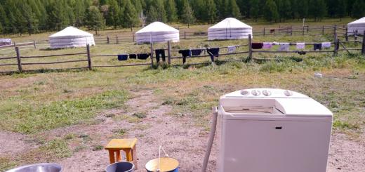
The photo shows the houses where people still lived until 1995. And I think that in best years stagnation, about 100 people wintered here. The houses are in good condition and, if desired, you can spend the winter in them. The pantries have stocks of rendered fat in jars and some cereals. Delicacies and alcohol are missing.

The Shokalsky glacier slides down from the Central Ridge of Novaya Zemlya with a long tongue and breaks off into the Russian harbor.
You can ride on the glacier, although of course it is gentle. But if you go 8-10 km inland, then the slope there increases, I think, up to 15-20 degrees. But I was no more than 2 km away. (To move around Novaya Zemlya, and even more so on the glacier, is supposed to be only in pairs, because of the polar bears, which, they say, have become too many. But we did not see them.)

A wide strip of flat ice stretches along the edge of the glacier, 
which turns into impassable cracks 
and sugar heads.
It is very pleasant to accelerate in a straight line and roll along the edge of the beginning rifts. They are usually flattened out and throw you into the air like springboards. The main thing will stop at the edge of the glacier ...
A strong wind almost constantly blows from the glacier, which sprinkles the ice with fine brown dust from the surrounding mountains. The grains of sand are heated in the summer sun and fall 2-3 cm under the ice. Therefore, the ice is gray or brown. The surface becomes spongy and provides excellent glide.


It is a pleasure to edge the skis.
In general, given the gentle slope, it is an ideal place for training beginners. Exactly, no snow groomers are needed, the wind has smoothed everything over many hundreds of years. At some point, the wind died down and then everything was filled with an unprecedented silence, which pressed on the ears. Unforgettably.
The surrounding landscape can only be described in one word - desert. What the deer eat there, the tracks of which we found, I personally do not understand. The surface of the earth is loam mixed with small pebbles. I managed to see several specks of lichens, 1 cm high. And that's it! It is also unclear how the deer climb over this glacier. Apparently, if you move into the interior of the island, then there are smooth areas. Sailing on the sea is difficult. The water is about 0 degrees.
The surrounding bays are inhabited by waterfowl. But their meat stinks strongly of fish. From under the glacier flows a small river with cold water, which is very good for diluting alcohol :-) My head does not hurt in the morning. Yes, information for the "green": NO RADIATION... I don't know why, but no. Experienced men, with whom I beat there, say that in the center of the island there are sometimes closed lakes with increased radiation. But only in the test area. And this is much to the south. Apparently nature has learned to deal with its main enemy - man.
And besides Novaya Zemlya, we also sailed to Franz Josef Land (80 N)

But there, unfortunately, I did not ride or land. It's a pity ... Theoretically, it's better to skate there. There are small glaciers and a lot of snow, which periodically falls and melts in summer.
In general, the north is as shaking as the mountains. If it would be possible to spend the winter on Cheget and wander around Novaya Zemlya in the summer, then it would probably be happiness. But, unfortunately, it doesn't work ...
It remains to add that all this beat is organized with the help of MAKE (Marine Complex Arctic Expedition) and its leader Boyarsky Petr Vladimirovich... And, besides skiing, there was also work together with the permanent employees of this organization, superbly cool men!
RUSSIAN HARBOR
5th of August. The ocean is calm. A little fog. Everyone crowded around the board „ Latest news“. It has a telegram from the Sibiryakov icebreaker:
“In the morning we passed Kanin Nos. On August 8 we will be in the Russian harbor. We carry parcels, letters, newspapers and magazines. "
Most of all we are interested in newspapers, magazines. Hurry to find out the news from the Big Earth!
At 20 o'clock. 30 minutes. in the logbook noted:
“Happy place 76 ° 35? north, 62 ° 45? ost. The shore of Novaya Zemlya appeared in the fog. The place is difficult to identify. With the right anchor etched away, we move forward. The fog breaks and goes south. "
On the captain's bridge, the commanding staff does not leave the Zeiss "cannon".
Yes, this is the Russian harbor! You see - Bogaty Island, Cape of Consolation, - wiping glasses, sweaty from the fog, says prof. Samoilovich.
Russian harbor, Bogaty Island have not seen a single large ship in their waters.
Hundreds of years ago, Russian Pomors came here on small sailing boats covered with bull skins to hunt for sea animals - walrus, bald, seal and seal.
In winter 1913, making his way on dogs from the wintering site of the Svyatoi Foka to Cape Zhelaniya, Lieutenant Georgy Yakovlevich Sedov came here first, determined the astronomical point and put these places on the map.
After 14 years on a small five-power boat "Timanets", leaving the schooner "Zarnitsa", prof. RL Samoilovich with two bold companions - Ermolaev and Bezborodov explored the geologically unknown northwestern shores of Novaya Zemlya. Traveling across the ocean in a small boat 18 feet long was quite dangerous. It would be enough to start with a wind force of 3-4 points, as this “nut shell” would be swept over by a wave.
All the way from the island of Barents Samoilovich had to walk in continuous fogs. Fortunately, the boat safely passed a number of reefs and pitfalls, located in abundance at Cape Consolation. A beautiful harbor, sheltered from the wind, was discovered (the future base for the Kara expeditions), which was named Shapkino stanovishche. After half a day's rest, prof. Samoilovich examined the geological structure of the island, climbed a high rock and saw on Bogaty Island a huge five-meter Old Believer cross with a half-erased inscription:
„THIS CROSS IS DELIVERED BY SUNGS
ON THE ISLAND RICH. FORMER BARENS.
IN 1847 ... "
Until now, one cannot but bow before the courage in the heroism of the Russian pomor-hunters, who reached the places on sailing boats that seemed inaccessible to their descendants. The role played by the Pomor fishermen in the development of the Arctic polar regions is very great.
From the book by John Lennon the author Goldman AlbertChapter 5 Strange Harbor The Dykins house at number 1 on Blomfield Road was rather unsightly. It was a small building, adhered to the neighboring one and similar as two drops of water to all the other houses on the street, and at the same time it seemed almost abandoned. In the garden
From the book Catcher in Dream: My Father J.D. Salinger the author Salinger Margaret A29 Harbor of Mind Joining Brandeis was the best decision I have ever made, or, to put it more accurately and more humbly, the greatest luck of my life. Now, in hindsight, it seems to me just as important to my mental health and
From the book History of the U-69 submarine. "Laughing cow" by Metzler JostCHAPTER 28 NEUTRAL HARBOR - AN INHABITED ISLAND U-69 walked slowly towards the island harbor. The routine of tropical travel began again, and yet, after a long stay near the equator, the slightly lower temperature was much more pleasant. It seemed to the submariners that
From the book of Movie Stars. Paying for Success the author Bezelyansky Yuri NikolaevichA quiet haven named Catherine? After the divorce, Michael Douglas devoted himself almost entirely to unaccountable entertainment and the search for new sensations. He hooked girls wherever he could: on the set, in bars, on the street. Suddenly, the actress Elizabeth Vargas lingered in his company.
From the book Confessions. Thirteen portraits, nine landscapes and two self-portraits the author Chuprinin Sergei Ivanovich From the book Admiral's routes (or flashbacks and information from the outside) the author Soldatenkov Alexander EvgenievichA navigational accident near Cape Gavrilov in Sovetskaya Gavan Bay (of course I am a scoundrel in this situation, but the truth is more expensive) It happened by chance that I was lucky to be navigators. To confirm this, it is enough to say in what positions they finished their service. First,
From the book Pushkin the author Grossman Leonid PetrovichVI WOLF HARBOR 1 From the corner balcony of Reno's house, a wide view of the bay and roadstead opened up. Above the roofs of white houses, built of flat slabs of spongy shell rock, the southern sea spread in its endless blue veil. Pushkin stayed in a "club" hotel,
From the book Voyage to the Heavenly Kremlin the authorChapter 26 THE LAST HARBOR When I talked about how Daniel returned from the front and we began to live together, I tried to convey what happiness is. For twenty-three months after our release, we wandered about in other people's homes. Your room, 15 meters high, in a two-room communal
From the book Writers' dachas. Drawings from memory the author Mass Anna VladimirovnaSafe Harbor Following the first play, the second appeared - "On Friends and Comrades", also an easy, unpretentious musical comedy about how fellow soldiers part after a victory and how their post-war fates developed differently. The play started just the same
From the book History of Russian chanson the author Kravchinsky Maxim EduardovichPart II. "Russian song - Russian history" The first Russian songbook "We also had our own" actors "- buffoons, their own mastersingers -" kaliki perekhozhny ", they carried across the country" acting "and songs about the events of the" great turmoil ", about" Ivashka Bolotnikov ", about
From the book Voyage to Heavenly Russia the author Andreeva Alla AlexandrovnaChapter 28. THE LAST HARBOR When I talked about how Daniel returned from the front, and we began to live together, I tried to convey what happiness is. For twenty-three months after our release, we wandered about in other people's homes. Your 15-meter room in a two-room communal apartment
From the book Pushkin the author Grossman Leonid PetrovichIX WOLF HARBOR From the corner balcony of Reno's house there was a wide view of the bay and roadstead. Under the roofs of white houses, built of flat slabs of spongy local limestone, the southern sea spread out in its endless blue veil, as if beckoning to distant lands lying on that
From the book The Stubborn Classic. Collected Poems (1889-1934) the author Dmitry Shestakov From the book by Giordano Bruno the author Steckli Alfred Engelbertovich30. "Someone else's harbor and people are alien ..." Alien harbor and people are alien, and the bright sky Like someone else's. You look - you dare not believe your eyes. Streets - the seas are noisier, and the air is in flames, and the gold of passionate rays pours out an enchanting day. The cage has opened - run! .. But what are you looking at,
From the book Once upon a time Gogol ... Stories from the life of a writer the author Voropaev Vladimir AlekseevichCHAPTER SIX WHERE IS HIS HARBOR! Theologians engaged in preliminary investigation call Bruno's views heresy. He faces a dilemma. He either must admit his guilt, or, persisting, to please the Inquisition. And then what? Holy service is not a suitable place for philosophical
From the author's bookThe Russian soul Gogol did not need to find out whether he was a Little Russian or a Russian - his friends dragged him into disputes about this. In 1844, he answered the request of Alexandra Osipovna Smirnova in the following way: “I’ll tell you one word about what kind of soul I have, Ukrainian or Russian, because this is how I
Sp Rùskaja Gãvanės įlanka Ap Russkaya Gavan Bay / Zaliv Russkaya Gavan ’L Barenco j., RF prie N. Žemės ... Pasaulio vietovardžiai. Internetinė duomenų bazė
Russian oceanic expedition to Spain (1725-1726)- Russian oceanic expedition to Spain (1725 1726) ... Wikipedia
Russian America- the unofficial name of Russian possessions in the 2nd half of the 18th and 2nd half of the 19th centuries. in Alaska (See Alaska), Aleutian Islands, north west coast North America up to 54 ° 40 n. sh. The name arose after the expedition of V. I. Bering and A ... Great Soviet Encyclopedia
Japanese-Russian war of 1904-05- Russian-Japanese War Top: Ship during battle. Clockwise from left: Japanese infantry, Japanese cavalry, two ships of the Russian fleet, Russian soldiers stand over a trench with killed Japanese during the siege of Port Arthur. Date February 8, 1904 ... ... Wikipedia
Japanese-Russian War 1904-05- (For general reasons for the war, see Japan) In March 1902, Russia, in the types of protection of the East China railroad, occupied Manchuria with its troops, pledging to evacuate it within three terms; the last one was October 8, 1903. The obligation is ... ...
Japanese-Russian War of 1904- For general causes of war see Japan. In March 1902, Russia, in the types of protection of the East China Railway. roads, occupied Manchuria with her troops, pledging to evacuate it within three terms; the last one was 8 Oct. 1903 This obligation was not fulfilled ... ... Encyclopedic Dictionary of F.A. Brockhaus and I.A. Efron
Anglo-Russian war- Napoleonic Wars Date 7 November 1807 18 July 1812 Place Finland, Mediterranean ... Wikipedia
Portal: Arctic / Projects / Islands of the Novaya Zemlya archipelago- This project was created to coordinate work on the creation of articles on the islands of the Novaya Zemlya archipelago. On the basis of the project, a list of islands in the Novaya Zemlya archipelago was created. Contents 1 Map 1.1 Scale 1: 200,000 ... Wikipedia
Arctic / Projects / Islands of the Novaya Zemlya archipelago- Portal: Arctic / Projects / Islands of the Novaya Zemlya archipelago This project was created to coordinate work on the creation of articles about the islands of the Novaya Zemlya archipelago. On the basis of the project, a list of islands in the Novaya Zemlya archipelago was created. Contents 1 Maps 1.1 Scale ... Wikipedia
Bays and bays of Russia- List of Russian bays and bays by seas. Major settlements on the banks of bays (bays) and rivers flowing into them. Contents 1 Atlantic Ocean 1.1 Black Sea ... Wikipedia
NEW LAND- architect, between the Barents and Kara seas North. The Arctic Ocean; Nenets JSC. All in. polar countries, the word land is usually for the name of the islands. The definition new in this case should be understood as later discovered, later mastered in comparison with ... ... Geographical encyclopedia
The diaries of the flight are kept daily by Natalya Avdonina, Ph.D. D., Associate Professor of the Department of Journalism, Advertising and Public Relations of NArFU named after M.V. Lomonosov.
Information about the location of the vessel "Professor Molchanov" can be obtained at.
In the high-latitude Arctic, all terrestrial flora and fauna are unevenly distributed. Most of the space we have traveled through is lifeless. Any flower, any bird is perceived rather as an exception than a rule.
The ninth day of the expedition. No internet since Saturday evening, July 14th. We live outside of time and space. Yesterday, imperceptibly for everyone, turned into today. We approached the Russkaya Gavan Bay at 21.35.
- "Alter Ego". "Professor Molchanov". Inform the location, the number of people. What are your problems?
- "Professor Molchanov". 10 people on board. Everything is fine. We go to you.
On line 16, our vessel received a distress signal from the yacht "Alter Ego". When she approached "Professor Molchanov", our expeditionary group was already heading towards Lake Retovsky. They went to Russkaya Gavan to wait out the bad weather. The clock shows two nights.
We went to land in six boats. The team of "nerds", as they called us on the bridge, set off last. On the first, rangers and geologists left to check the station for polar bears that could be waiting for us in the destroyed buildings.
Three field teams worked ashore: to collect geological and biological samples and marine debris. A group led by Anna Vesman was collecting garbage within a hundred meters from the coast in order to sort and identify the main sources of pollution. Fishing nets, small household items - all this is beaten by the wave and remains lying on the abandoned shores of the Russian Harbor, waiting for the next expedition.
We were given the go-ahead to prepare for disembarkation at about one in the morning, when almost all the other groups returned to the ship. The Zodiac kept rolling as we descended into the boat. Coastal water Barents Sea has an incredible aquamarine hue due to its reduced salinity.
We stepped onto the rocky ground of the Russian Gavan, which, according to observations in the 1970s, was arctic desert... Now this land is more like a tundra, according to Dmitry Nikitin, a fourth-year graduate student at the Faculty of Soil Science, Lomonosov Moscow State University.
We made our first stop near a shallow stream. Andrey Przhiboro, senior researcher at the Zoological Institute of the Russian Academy of Sciences, set up traps for insects and began to walk with a net, squatting every five minutes and removing mosquitoes from it. Andrei Alexandrovich explained that he does not count the number of samples collected, but the points where these samples were taken. At the same time, he collects coastal and bottom substrates, from which he then extracts insects or other invertebrates, including larvae, and grows them under laboratory conditions in the collected soil. Andrey Alexandrovich will rinse each such bucket for several hours and lower it into salt water so that the insects float up.
“It's interesting to do research on adaptation, to see how insects, for example, withstand such cold conditions, what they eat. It is necessary in the future to raise questions: who, where and how long they live. Now I am raising these questions, but work on specific points is necessary in order to draw serious conclusions, ”said Andrei Pzhiboro.
Dmitry Nikitin began the first excavation of the soil. He looked for areas of the landscape with characteristic relief and vegetation. “The soil is a mirror of the landscape, which reflects all the biological and geological processes that have taken place over the past several hundred and tens of thousands of years,” Dmitry said.
Dima dug up the ground in four different locations, described the surrounding landscape, plant community and soil horizons. From each point, he took samples for chemical, physical and microbiological analyzes. Most importantly, the last, microbial test. More or less comprehensive studies of Novaya Zemlya were carried out in the 1970s, but since that time the climate has changed significantly, which is sure to affect flora, microbes and soil composition. “At least it should have,” added Dmitry. And it is microbes that quickly respond to environmental changes. It takes hundreds of years for a rainforest to turn into a desert or shroud, and the microbial community can change in a few months. Microbes are bioindicators of the environment that can be used to determine the level of soil contamination, for example, with heavy metals.
“We will conduct a comprehensive study and try to link several indicators with vegetation, relief elements, thus getting a global picture of terrestrial ecosystems, at least a small piece of Novaya Zemlya,” Dmitry said.
We walked a few more kilometers and made a halt on a hill. While most of them were getting sandwiches, Dima Nikitin began to dig up soil horizons, and Sergei Kholod, Doctor of Biological Sciences and head of the laboratory of geography and cartography of vegetation at the V.L.Komarov Botanical Institute, examined the plants. The vegetation in the Russkaya Gavan is richer in the composition of species, and an interesting find for Sergei Serafimovich was the dryad, or partridge grass, as it is popularly called. This grass forms carpets on the western and southwestern slopes. Several plants that Sergei Kholod found are absent on Cape Zhelaniya: otrigel and mytnik. Some others still need to be explored and pinpointed. "A small route within three hours cannot be called a complete survey of the territory, this is only a preliminary exploratory excursion," said Sergei Serafimovich, "which in general terms allowed us to outline points for future descriptions." Sergei Kholod plans to return to Russkaya Gavan later to carry out long-term systematic work.
The study of vegetation is interesting in that it makes it possible to reveal the dependence of vegetation on environmental factors - plants are sensitive to changes in the chemical composition of soils. Sergei Serafimovich cited as an example stemless resin, which forms the pillows necessary for life on dry terrain. In Russkaya Gavan, a researcher noticed the death of pillows, which may be a sign of unfavorable conditions, but what kind of conditions these are is a question for further scientific research. Of course, it is impossible to say for sure about climate change in several decades, it takes a hundred years or more. For example, it can be assumed that the influence of the sea increases, that is, more salts are introduced, and the plants cannot adapt to the fact that the soil becomes brackish. As a result, the plant dies.
From time to time we found deer bones. 14-15 years ago, almost all the islands of the Russian Arctic warmed in the fall, and ice was formed, due to which the deer could not break through the ice crust and died of hunger. This is also an anomaly that has yet to be studied.
A group led by Nikolai Matushkin, senior researcher at the laboratory of geodynamics and paleomagnetism of the Central and Eastern Arctic, associate professor at the Department of General and Regional Geology at Novosibirsk State University, took 23 core samples. Not all layers are suitable for drilling, only monolithic ones. In each layer, researchers need to drill 10-12 cores. One point takes from one to two hours. As Nikolai said, with one colleague he had a record - they accelerated to 40 minutes, but the rocks for this must be easy to drill. The cores contain magnetic minerals, geologists are only interested in iron and titanium oxides. Particles of these minerals, settling, are oriented to the cardinal points. The place where Vasily Bragin, a researcher at NSU, drilled, is the same sea on which we are sailing now, only a few hundred million years ago, when an ancient magnetic field existed on earth. Since then, a piece of continental crust has traveled, tilted, and now the direction laid down hundreds of millions of years ago does not correspond to the modern magnetic field. If geologists succeed in constructing a model of the movement of the continents, this will be another argument in the geopolitical discussion about how the shelf works. “The results that we have been getting since 2003 are already being used by a special UN commission to substantiate Russia's position on shelf expansion. From a scientific point of view, it is interesting, because it is possible to distinguish blocks of the earth's crust that were considered part of one continent, and we can prove that this is a separate small continent, ”Nikolai said.
Andrei Przhiboro said that the first expedition to the Russian Harbor to study insects was set up in 1837 by Karl von Ber. Almost every subsequent expedition here ended in the death of people. Russian Harbor for me will remain an unsociable, cold-blooded, merciless place that must be visited at least once in my life in order to forget about the omnipotence of man.
reference
The Arctic Floating University project of NArFU is an innovative project that combines science and education. The expeditionary project of NArFU is aimed at obtaining new knowledge about the state and changes of the Arctic environment in order to implement recommendations for ensuring the sustainable development of the region, preserving its ecosystem in the face of global climate change. The organizer of the project is NArFU named after M.V. Lomonosov in cooperation with the Federal State Budgetary Institution Northern Directorate for Hydrometeorology and Environmental Monitoring. The project consists in conducting complex marine scientific and educational expeditions in the Arctic region, with the participation of leading researchers and students of NArFU and with the involvement of specialists from all over the world.
The innovativeness of the Arctic Floating University project lies in the integration of educational and research processes. During expeditions, students and postgraduates of NArFU intensively immerse themselves in the scientific and educational process, study fundamental natural sciences and humanities, acquire the skills and abilities of practical work and laboratory research based on modern methods of analyzing statistical, mathematical, cartographic, GIS information, as well as field scientific research in expeditionary conditions.
Expeditions are carried out on the research vessel "Professor Molchanov", owned by the Federal State Budgetary Institution "Northern UGMS". The vessel complies with international environmental and safety standards, allowing for long, expeditionary voyages in the Arctic.
In the evening we will come to the Russian Harbor, from where we will move to Alexandra Land, making a cut. There will be 18 points in total - this is work for more than a day. In Arkhangelsk today +28. As Alexander Saburov said: of course, it was worth leaving. But ours is not bad either: it is quiet, the sea of a beautiful gray-lead hue, Novaya Zemlya is on the starboard side, it is slightly hidden by fog, then it sets off the horizon. Maybe in the water area of the FZI we will meet the Sea Spirit - a tourist ship that goes on the route Svalbard - FZI. Today it is near Alexandra Land. I just don’t remember whether it was going forward or back to Svalbard.
Unicorn by Ingo
From 4 pm today, many come to the bridge hoping to see the sea unicorn. Ingo Weiss is to blame for everything. He shot something on the telephoto. And when he began to consider this something, it turned out that it was the narwhal who had stuck his horn out of the water. Modestly, but you can immediately see that it is a narwhal. We got it, more precisely, Ingo, at 76 degrees north latitude off the coast of Novaya Zemlya. This is not the most typical meeting place for a narwhal. And, as far as I remember, for last years no one mentioned such facts. The most characteristic meeting place for sea unicorns in the Russian Arctic is the Cambridge Strait off the coast of Franz Josef Land. Although, in principle, the range of narwhals is the entire high Arctic. Most of the population - about 70% - lives in the waters of the Canadian Archipelago.
Narwhal
A rare marine mammal also called the sea unicorn. The body length of an adult narwhal is up to 4.5 m. The main feature of a narwhal is its tusk or horn, which grows up to 2-3 meters, twisting in a spiral. This is actually the upper tooth, usually the left one. The tusk is typical only for males.
True, as I came across in the literature, theoretically a horn can grow in a female if she has hormonal disorders. And in 1 case out of 500 (this is already talking about males) both teeth grow and a bicorn is obtained. There are such skulls in museums.
But why do unicorns always appear when I fall asleep? ..
From the life of ice
Novaya Zemlya and Franz Josef Land, where we are going, are some of the most icy areas in the world, and in Russia, it seems, the most icy ones. As Alexandra Urazgildeeva said today, glaciers cover 0.5% of the earth's surface, and the Antarctic ice sheet - 8.3%. Frozen water can be in the form of snow, river and lake ice, sea ice, ice sheets, glaciers and ice caps and permafrost.
They say that the Arctic is getting warmer, and this can be seen from the sea ice in the North Arctic Ocean... Recently, its number has been steadily decreasing. The record was set in 2012. Nothing like this happens in the southern hemisphere. Antarctica exists as if by itself. Although the ice sheet of the southern continent seems to be shrinking, it shrinks in the western part, while in the eastern part, on the contrary, it grows.
Anna Vesman told how ice forms and melts. This is a long process, which has several stages, which are called in different ways and curiously: ice needles, bacon, snow, sludge. Then comes the dark nilas and the light nilas. Nilas is the stage of ice formation, when it still contains a lot of salt and remains plastic. Young ice is gray at first, then gray-white. If you are lucky, he will mature and become old at first, then perennial. In the Arctic, ice over 4 years old is concentrated in the area of the Canadian Archipelago.
And, in order of listing: there is pancake ice - very beautiful round pieces of ice. In English it is pancake ice. Anna said that once at a conference the term was translated as "pancakes". There is also anchored ice and fast ice - this is important for us. If the island has fast ice, the landing will not take place.
I will not write about the stage of sea ice melting: it is even more difficult than formation.
Breathing of soils
During the voyage, the soil group will study not just soils, but, as Sergei Goryachkin, head of the department of geography and evolution of soils at the Institute of Geography of the Russian Academy of Sciences, said, the respiration of soils. For the first time on Novaya Zemlya and the FFI islands, the amount of carbon dioxide and methane released from the soil surface will be measured.
The roots of plants and microorganisms breathe in the soil. And, like us, they emit CO2 into the atmosphere.
Carbon dioxide is a greenhouse gas. Another such gas is methane, CH4. It gives off where there is waterlogging.
Each measurement is accompanied by a measurement of temperature and humidity. For each region we try to build its own model of how much CO2 and methane is released per year.
In theory, if more greenhouse gases are emitted, a greenhouse effect occurs. But an increase in their number leads to an increase in phytomass, which absorbs CO2. Therefore, the final effects should no longer be calculated by soil scientists or geographers, but by other specialists. In general, the topic of climate change is multidisciplinary. Everyone learns something of their own. But to create a whole picture and say what awaits us at least in the foreseeable future is the most difficult thing.
Another soil group will take soil samples. It would seem to dig it up and that's it. But it’s not that easy. These soils are accustomed to low temperatures, and if they are brought, for example, to Molchanov, the result of their research will be distorted.
Therefore, we take and immediately put samples in the freezer. In addition, we have such insulating boxes, and we hope that we will take them to the refrigerator in the laboratory, '' said Sergei Goryachkin.
Once they tried to grow a lemon at the Omega base of the Russian Arctic National Park. Soil was collected near the cordon, mixed with all sorts of organic residues, algae, to get some kind of soil, to which we are accustomed. Lemon, by the way, has grown, but I don't know its further fate. I asked Sergei Viktorovich if there is any ground in the FFI in principle. The question, of course, is an amateurish one. Sergey Viktorovich very patiently explained to me that there are soils wherever there is life.
Where there is life, there is an interaction between the organism and the mineral. This is practically the beginning of the soil. Of course, these are not dachas near Moscow, there is no need to plant potatoes, but in order to maintain life, this is quite enough.
Chelyuskinites from Eric
Eric Hösli continued his excursion into the history of Russia's exploration of the Arctic. Today the Soviet period was considered: SP-1, the first polar station at the ZPI in 1929. By the way, it was organized very urgently: the expedition was assembled in record time, because a Norwegian expedition was heading to the FZI at that time. The Soviets were more fortunate with the ice conditions.
An interesting point: how the development of the Arctic in the 1930s was linguistically presented. A lot of military vocabulary was used: the conquest of the Arctic, the army of polar explorers, the storming of the Arctic, the Arctic front, the fight against the elements ... Well, that's how it is with us. The struggle for the harvest, the struggle with the harvest, life is a struggle, otherwise it is not interesting. Indeed, it turned out to be a struggle and conquest. It was all too difficult. And how many heads then flew off.
Finally, Eric showed the Chinese Army's official world map from 2017, with the Northern Sea Route and the Northwest Passage marked on it. The Chinese are very interested in the Arctic ...
PHOTOSESSION
Molchanov will host the first wall newspaper from APU-2017. The idea from Eric Hösley is to take pictures of all the participants and hang out portraits with names and a short ... how to call ... a description ... In general, who does what on the voyage. It was necessary to conduct a photo session in the morning, while it was cloudy. I think, along the way, I will re-photograph then for the site of all already against the background of the sea. Today it was important to hurry up so that no one was squinting and the wind was blowing.
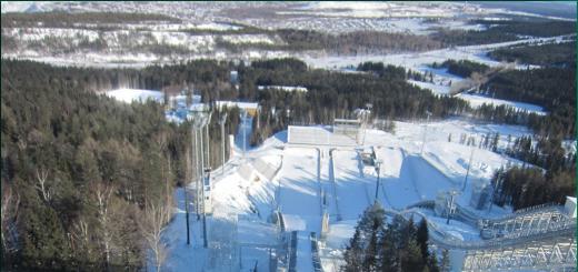
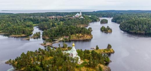
Russian Harbor and Shokalsky Glacier
At about 7 pm we came to the Russkaya Gavan Bay - one of the largest on Novaya Zemlya. This is what the Norwegians called it, because there were many Russian (Pomor) crosses on the shore. In the bay it was possible to hide from the storm. Next, I will use my own blank, which I once made for an exhibition dedicated to Novaya Zemlya.
Russian Gavan
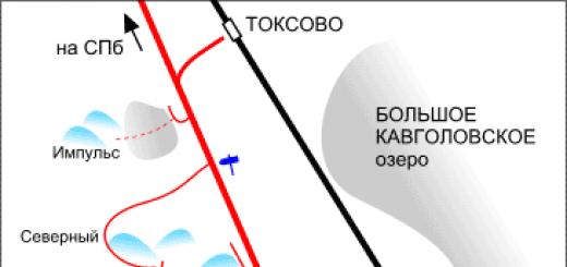
The bay is located on the western - Barents Sea - side North Island Novaya Zemlya between the Litke and Schmidt peninsulas. The bay is open to the north and penetrates into the interior of the North Island for 10 km. Its space, together with the Goryakov and Savich peninsulas, is divided into a number of separate water areas: Volod'kin and Voronin bays (in the east), Otkupshchikov Bay (in the west). The distance between the entrance capes Makarov (in the west) and Utesheniya (in the east) is 8 km.
Approximately Russkaya Gavan Bay was mapped in 1871 by the Norwegian industrialist Friedrich Mack. The name was given by the Norwegians in 1869-71. in honor of Russian seafarers who visited these remote places long before the Europeans, undoubted proof of which are the old Pomor crosses, later found by the explorers of the Russian Harbor. On the Goryakov Peninsula and the Bogatom Island in the 30s of the twentieth century. the crosses were still preserved.
In 1932 the Russian Gavan polar station was opened. It was located at the base of the Goryakov Peninsula, on the second sea terrace 15 m high. The houses stand on the flat surface of the isthmus between Voronin Bay in the east and Otkupshchikov Bay in the west. To both bays, the terrace on which the station buildings are located has a slope of 5–7 °.
Currently, four buildings remain on the territory of the former polar station: the main building of the 1930s. with two laboratories (meteorological and hydrological) and a radio station; residential building of the 1950s; bathhouse and outbuilding. It was at the polar station "Russkaya Gavan" that the famous film "The Seven Bold" about the real events of 1932–1933 was filmed.
In 1932, a camp was also founded in Russkaya Gavan. It was located 1 km north of the polar station, in the area of the modern beach on the Goryakov Peninsula, at a height of 1.5 m, at a distance of 3-4 m from the modern coast. In 1957-1959. its premises were used as a base for the Novaya Zemlya Glaciological Expedition of the Institute of Geography of the USSR Academy of Sciences, which worked under the program of the International Geophysical Year. From the buildings of the encampment, only the former warehouse and the saloon have survived. The rest of the buildings were dismantled or burned down.
From the south, the Shokalsky glacier descends into the Otkupshchikov Bay, the frontal cliff of which is 5 km long. The height of the glacier wall is about 30 m. The glacier produces a year, that is, slides into the sea by about 150 meters.
It is beautiful, of course, this Shokalsky glacier. No matter how much I tried to convince myself that I had a million photographs of him from all sides, I started photographing from the window. Then look for another hat, not the one I wore here last year. Found it. And at that moment the phone got down! But you can't help but be photographed on your phone. If you don't have a selfie, then consider that you weren't.
Konstantin Sergeevich began to drive those without hats. The rules are harsh: those who do not care about their health are deprived of landings. There were precedents.