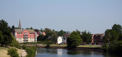
Located on the border of two regions - Krasnodar Region and Karachay-Cherkessia. The nearest settlement - the village of Mountain, which is included in Akhmetovskoe rural settlement of the Labinskiy district. The lake itself is already on the territory of the KCR.
Lake black on the map:
Map is loaded. Please wait.
Unable to download the map - please activate JavaScript!
Black Lake 44.103920, 41.139507 It is located at an altitude of 785 m above sea level. Lake width - 200 m, and the greatest length - 450 m. Black lake
Lake
One of popular seats relaxing among residents of the surround settlements. Lake Karst origin, the maximum depth does not exceed 8 m. It is at an altitude of 785 m above sea level. The width of the lake is 200 m, and the greatest length is 450 m. A thick forest grows on the shores of the lake: beech, oak, Iva, etc. The black lake cannot be called clean, the bottom of it is grown, the reed is growing along the shores. However, among the locals there is an opinion that the water of the lake is able to heal wounds.
Photo by Alexei Zagagayko
Neighborhood
Almost all sides of the lake surrounded by a dense forest. And only from the northern side there is a small glade. Without reaching 50 m to the lake, there is a table with benches.
 Photo by Alexei Zagagayko
 How to get
 Photo by Alexei Zagagayko
 From Krasnodar to the village of Mountain - 260 km.
Behind the village the road turns into a rut that leads through the field. She often loops, here the coordinates of the site, which will lead to the lake:
Latitude: 44.1051335,
Longitude: 41.1321473.
From this place remains approximately 100 m to the lake. If the car's permeability allows you to drive almost close to the lake.
Want new impressions? On the expanses of the lake, there are a lot of holes, underwater islets, deep plateau. Echo sounder sees a lot of fish. And where it is with a screen, there and a fisherman with a crochet. Overlooko in the Ushachsky area of \u200b\u200bthe region known as "Curve". This is because at a length of less than 10 km has a 40 km coastline. Nonstandard in it and in depth - from shallow water and up to 16 meters. Another feature: In the lake, a whole archipelago was fitted - 7 islands.
Myththyofauna is mostly a bream-shock. But the general set of species is wide. Here you catch: Caras, lines, roach, perch, gouser, crayfish. In the source arising from the lake River Diva there are red-bubble acne.
Spring
Winter season is closed during March. In March, the wells drill at depths from 3.5 to 10 meters. Prcinarity is a tear, seeds, ready winter feed for bream. Catch for Mermatku. The roach from the ice is very active, small checkers and pillars also constitute permanent part Ulova. And the Fish Liberated Father's Fish Libeos provide a wide choice of methods and places of fishing;). Some are looking for a predator with rubber, while others remain true and manewn gear.
In summer
In June, as in other months, there is an acute problem with approach to the lake. Many comfortable parking lots, especially on weekends, filled to refusal. But quiet places Can be found. For example: get to the middle of the village of Kozyany, there to move to the meadow above the lake. A steep descent to the shore will have to be made on foot. In the heat, wobblers with long petal and turntables are often triggered. With a jig tackle, they catch in thickets of floating plants, as well as at a depth of 2-3 meters - on the edge of pure water. Echohotes usually show fish on the fellows, especially in the District of Baby Mountains. 
In autumn
This time of hunting for predatory fish love masters of trolling. In September - October on the lake can be counted up to one and a half dozen boats, from which they catch this method. Basically, the pike, on the border of the reed and clean water. Those who do not accept such tricks use gallops and mugs. Sometimes on the brows flies pike 3 and even 5-kg. In November, luck depends in many respects from the weather whims. Catch more in those places of the lake, where the depth in the area is 10 meters.
Winter
She leaves the lover only two types of fishing - and glittering at the wells. In theory, fish should still be as they caught. But it is necessary, many complain that the rates are without movement, and the fishing rod works. Although the echo sounder shows what and there, and there is a fish. And the lore is completely the same. But anyway, guster, roach and perch of the most responsive inhabitants of the depths. Moreover, the perch at this time squeezes to the shores. And for some reason, the pillars increase the activity when the sun shines.
The area of \u200b\u200bthe mirror is about 3.76 km² (by other data from 3.38 km²), length is 6.71 km, the largest width is 1.12 km, the maximum depth of 17 m, the length of the coastline is about 17.3 km. The volume of water is about 19 million m3.
Tiletskoe (Cherepet)
Coordinates: 55? 57'48 "N 28? 45'36" E
View from cosmos
Lake Tiletskoe is located in the Rosson district of the Vitebsk region, on the border with the Pskov region (RF), 6 km north of P. Rosson, about 1.8 km north from the village of Glota and refers to the pool r. Thread (Ave. Inflow R. Dribissa). On the south side, it is focused on a massive ridge, crouched forest and shrub. The shores sandy and sandy-clay, mostly low (in the north sublime), crouched by forest, places with shrubs and gentlemen. Shallow water is narrow, sandy, deeper bottom or sapropelist. The greatest depths are located in the central part of the lake, closer to the northern shore. Groans slightly. Through the lake flows r. Tiletic. Connected by wide ducts with Walkovsky lakes (in the East) and Millia (in the West). Falls river Rudnya and 2 streams. The area is mud-hilly, swampy, thick overgrown with forest and shrub, difficult to reach, almost unnecessary. The surrounding forests are rich in blueberries, lingonberries, cranberries, wild rosehip, as well as mushrooms. In the lake inhabit bream, pike, lin, roach, perch and others. Fish. Fishing fishing is produced. Organized paid amateur fishing.
Mirror area 2.03 km², length 5.45 km, the largest width of 0.94 km, the maximum depth of 5 m, the length of the coastline is about 15 km. The volume of water is about 6 million m3, the area of \u200b\u200bthe catchment is about 200 km².
Lake Cheles is located in the Miorsky district of Vitebsk region, 6 km north-east of the city of Miora, between the villages of the Chelema, a new village, Litoviki, Zakharny and Drying. Refers to the pool r. Meritsa (lion. Inflow r. Zap. Dvina). The locality is plain, in places the muddy, there are small forest arrays and landing. In the northeast there is an extensive forest array with a moss marsh. The shores are sandy, mostly low, places of chopped, shrub, seamless, places with gentlemen. Shallow water is narrow, sandy, deeper bottom or strength. The greatest depths are located in the central part of the lake, the maximum - in its northern part, closer to the North-West Bank, opposite the village of Zaharni. Groans slightly. Connected to OZ. Walnut wide second (in the south) and streams (in the East). 2 streams fall, fueled by several springs. In the lake there are bream, pike, roach, lin, red-pan, perch and others. Fish. Fishing fishing is produced. Organized paid amateur fishing.
The mirror area is about 0.91 km² (by Dr. data 0.99 km²), length is 3.3 km, the largest width is 0.53 km, the maximum depth is 12.8 m, the length of the coastline is about 7.75 km. Water volume 6 million m3.
Lake Chersel is located in the Novogrudsky district of the Grodno region, 24 km north of Novogrudok, near the village of Chersel and refers to the pool r. Neman. The terrain is predominantly flat, places are mud and hilly, mostly scrubbed forests, swampy places. The lake is surrounded in the West and East low (up to 5-7 m) ridges, shrub, places in places. In the south, the south-east and north is focused by extensive, places of wetlands. The shores are predominantly low, sandy, shrub, places, in the north of wetlands. The shallow water is extensive, along the shores sandy, deeper or statuary and sandy and sapropelist. Groans moderately. Through the lake flows a small r. Birch, connecting it (through an unnamed old old lake) with r. Neman. In the southwest flows a small stream. In the lake there are perch, roach, bream, pike, lin, and others. Fish. Fishing fishing is produced. Organized paid amateur fishing. The underwater hunt is allowed.
The area of \u200b\u200bthe mirror is about 0.44 km² (by Dr. 0.37 km²), length 1.17 km, the largest width of 0.45 km, the maximum depth of 1.8 m, the length of the coastline is about 2.9 km. The volume of water is about 0.38 million m3.
Cheryikovsky (Unnamed) *
In the area of \u200b\u200bCherikov, located 77 km on the south-east of Mogilev, in the surcharge and floodplain zones of the coolant rivers and the rods are 35 Unnamed floodplain and old lakes. Lake data belongs to the Cheryikovsky district of the Mogilev region. No information about their parameters and the surrounding terrain was not found.
Crymisman
The Malmisets Lake is located in the Polotsk district of Vitebsk region, 36 km north-east of Polotsk, about 1.9 km north of Dretun. Refers to the pool r. POLYTY (Ave. inflow r. Zap. Dvina). The terrain of the marshy, hard-to-reach, unnecessary. Shores are low, wetlands, densely overgrown with forest and shrub. In the south, flows the stream in Oz. Drretun.
Mirror area 0.22 km², length of about 1.2 km, the largest width is about 0.2 km, the length of the coastline is about 2.6 km.
Black uroda
Lake Black Uroda is located in the Ushachsky district of Vitebsk region, 22 km south-east of G.P. Ushachi, near the village of Horstovo and Mishulka and refers to the pool r. Diva (in the lower current is called Turner). Enters the Ushach group of the lakes. The terrain is predominantly hilly-dirt, shrub and gentleman, swampy places. The lake in the east and the south is surrounded by non-wetlands, which turns into a swampy meadow, a cane and rare shrub. The shores are sandy (in the south of splaversal), low shrubs, shrubs, swamp in places. The shallow water is sandy, narrow (in the north wider, the southern bay is completely shallow), deeper the bottom of sandy-orst and sapropelist. The greatest depths are located in the central part of the lake, the maximum - about 0.19 km from the eastern shore between the villages of Horstovo and Mikulki. Groans hard. In the south of Oz. The freak flows praks. In the southwest drops p. Belskaya connecting with a small unnamed lake. In the East is connected by a stream with oz. Head, in the West flows a small stream. In the lake there are perch, roach, bream, pike, lin, and others. Fish. Fishing fishing is produced. Organized paid amateur fishing.
The area of \u200b\u200bthe mirror is 0.55 km² (by Dr. 0.53 km²), length is 1.6 km, the largest width is 0.43 km, the maximum depth is 3.9 m, the length of the coastline is about 4.3 km. The volume of water is about 1.2 million m3, the area of \u200b\u200bthe catchment is about 95 km².
Black
Lake Cherninsky is located in the Beshenkovichsky district of Vitebsk region, 22 km north-east of G.P. Beshenkovichi, about 1 km south from the village of Chanovichi and belongs to the pool r. Ostrovnik (lion. Influx of river. Western Dvina). The terrain is predominantly mud-hilly, overgrown with forests, swollen places. The surrounding forests are rich in strawberries, raspberries, blueberries, lingonberries and mushrooms. The shores are predominantly low, sandy, shrub and gentleman, places in places. Groans moderately. In the lake inhabit bream, crucian, roach, etc. Fish.
The area of \u200b\u200bthe mirror is 0.012 km², length is about 0.14 km, the largest width is about 0.1 km, the length of the coastline is about 0.4 km.
Black
The lake is black in the town of Vitebsk region, 24 km northeast from the city of the town, about 2.7 km on the west of the village of Kozlovichi, between the lakes, rover and claro and refers to the river basin. Logsnyanka (Ave. Inflow p. Zap. Dvina). The terrain is predominantly flat, in places the mud, overgrown with a dense forest, in places are very wetlands, unnecessary.
The area of \u200b\u200bthe mirror is about 0.02 km², the length is about 0.28 km, the greatest width is about 0.17 km, the length of the coastline is about 0.8 km.
Black
Lake black (on topographic map The name is not marked) is located in the city district of Vitebsk region, 45 km north-east from the town of the town, about 0.7 km north-east from the village of Markchiki and refers to the river basin. Obol (Ave. inflow r. Zap. Dvina). The terrain is predominantly flat (in places the mud), the lowered dense forest, in places are very wetlands, almost unnecessary.
The area of \u200b\u200bthe mirror is about 0.05 km², length is about 0.1 km, the greatest width is about 0.06 km, the length of the coastline is about 0.27 km.
Black
Lake, black (on the topographic map, the name is not indicated) is located in the Moscow region of the Vitebsk region, 6.3 km from the border with the Pskov region. (RF), 19 km north-west from G.P. Rosson, about 2 km west from the marsh massif Big Moss, about 4.4 km on the south-west from the farm farm, about 0.3 km on south-west from Oz. Okunenets and refers to the river pool. Honka (Ave. Inflow p. Niche). The terrain is predominantly flat, places hilly-mood, overgrown with a thick forest, a very wetlands, unnecessary.
The area of \u200b\u200bthe mirror is about 0.07 km², length is about 0.4 km, the largest width is about 0.23 km, the length of the coastline is about 1 km.
Black
Lake Cherninsky (on topographic map The name is not marked) is located in the Rosson district of Vitebsk region, 1.2 km from the border with the Pskov region. (RF), approximately 25 km north-east of G.P. Rossony, 0.45 km northwest from the village of Voronino and belongs to the pool r. Thread (Ave. Inflow R. Dribissa). The terrain of the hilly-mood, overgrown with a dense forest, in places of a marshy, almost unnecessary. In the north is connected by a narrow collate with OZ. SHOE.
The area of \u200b\u200bthe mirror is about 0.04 km², length is about 0.4 km, the largest width is 0.17 km, the length of the coastline is about 1 km.
Lake Chernets is located in the Lepiel district of Vitebsk region, about 16 km northeast from G. Lepel, about 1.1 km on the south-west from the village of Red Selo. Refers to the pool r. Ulla (lion. Influx of p. Zap. Dvina). The terrain is predominantly flat, in places the muddy, densely overgrown with forest and shrub, in the south there are swollen places.
The area of \u200b\u200bthe mirror is about 0.023 km², length is about 0.31 km, the largest width is about 0.09 km, the length of the coastline is about 0.7 km.
Chernetsky *
Lake Chernetsky is located in the Gomel district of Gomel region, about 9.5 km south from G. Gomel, about 0.65 km north-east from the village of Chkalov, near the village of Razin and belongs to the river. Coolant (actually located in its floodplain). It is an old-type lake. In the south, there is a stream, a canal falls in the northwest. In the south, a narrow twist is connected to an unnamed old lake and through it with p. Coolant The terrain of the mud-hilly, in the east and southeast densely overgrown with forest and shrub, in the south there are swollen places.
Lake Blueberry is located in the Borisov district of the Minsk region, about 37 km in North-West from the city of Borisov, next to the border and belongs to the river basin. Berezina. It is part of the Berezinsky biosphere reserve. The terrain is predominantly flat, densely overgrown with forest (places of burlya), wetlands, difficult, almost unnecessary. Lake of the ancient type and is in the floodplain r. Berezina. The shores are low, sandy (peat beds), shrub, wetlands. Groans moderately. In the north flows the stream. Fishery fishing is prohibited, only amateur fishing is possible by unscheduled ways to vouchers. The use of motorflies with motors is possible for environmental tours (the charter of the Berezinsky biosphere reserve, approved by the order of the Office of the President of the Republic of Belarus from 21.06.2001 148). No other data characterizing the lake and the surrounding area was not found.
Lake Cenetnika is located in the Beshenkovichsky district of Vitebsk region, 28 km south-east of G.P. Beshenkovichi, about 0.8 km northwest from the village of Latigovo and belongs to the pool r. Cherničanka (lion. The influx of the p. Lucia). The terrain is predominantly flat, places hilly, lowland, mostly overgrown with forest and shrub, swampy. The surrounding forests are rich in a lounge and blueberries (perhaps the name of the lake received due to abundance in the vicinity of blueberries). The shores are predominantly low, wetlands, shrub and forest. Groans moderately. In the south-east of the resulting r. Chernyshalka is connected to OZ. Hidden. In the north and in the south 2 streams fall. In the lake there are perch, roach, bream, lin and others. Fish. Organized paid amateur fishing.
The area of \u200b\u200bthe mirror is about 0.12 km², the length of 0.71 km, the largest width of 0.27 km, the length of the coastline is about 1.92 km.
Chernitsky Moss (Unnamed) *
Lake Chernitsky Moss (Unnamed) is located in the Vitebsk district of Vitebsk region, 21 km south of Vitebsk, about 0.5 km on the south-west from the village of Chernitsky Moss, in the Chernitsky Moss tract and refers to the river. Cherničanka (lion. The influx of the p. Lucia).
Hotel (Unnamed) *
Lake Cheriff (Unnamed) is located in the Zhitkovichi district, approximately 12.3 km on the southwest from Zhitkovichi, about 0.5 km north of Chernichi. Refers to the pool r. Pripyat (actually located in its floodplain). It is an old-type lake. Connected by narrow twentieth in the West with a Unnamed Old Lake. 0.1 km in the north flows r. Pripyat. The land is low, in the south of the mud-hilly, places of shrub and a gentleman.
Chernovka
Lake Chernovka is located in the town of Vitebsk region, 27 km northwest from the town of Town, between Badekino villages, juice and Andreyenki and refers to the pool r. Obol (Ave. inflow r. Zap. Dvina). The terrain of the mud-hilly, crouched by forest, palpal and shrub, swampy places. The surrounding forests are rich in strawberries and forest walnut. The shores are low, sandy, mostly wetlands, shrub and pleadass. The shallow water is extensive (in the West and Southeast is narrow) sandy and sandy-orst, deeper bottom or strong. The greatest depths are located in the center of the lake. Greets weakly. There is a small island with an area of \u200b\u200bless than 0.1 hectares. Through the lake flows r. Chernuky (lion. Influx of r. Obol). In the lake there are bream, pike, roach, lin, red-pan, perch and others. Fish. Fishing fishing is produced. Organized paid amateur fishing.
The area of \u200b\u200bthe mirror is 0.14 km², length is 0.72 km, the largest width is 0.28 km, the maximum depth is 10.7 m, the length of the coastline is about 1.8 km. The volume of water is 0.51 million m3, the area of \u200b\u200bthe catchment is about 65 km².
Coordinates: 55? 34'33 "N 29? 51'49" E
View from cosmos
Lake Chernovo is located in the town district of the Vitebsk region, 13 km north-west from the town of the town, between the villages of Sakovo, Korsaki, Mijui, Klyowo, Vesnino, Lysk, Luka and Kostyukovo. Refers to the pool r. A draft that follows from the lake. The terrain is predominantly mud-hilly, (around the lake crushed overflows, shrubs and gentlemen), swollen sides, extensive forest arrays are located around. The surrounding forests are rich in raspberries, strawberries, lingonberries, blueberries, mushrooms and forest walnut. The shores of sandy, high, shrub, seeded with places, in the north, the abrasion places. The shallow water is sandy, narrow (in the bays wider, in the northwestern part of the extensive), deeper bottom or sandy and sapropelist. The greatest depths are located in the central part of the North-West and Southeast Ples, the maximum - in the central part of the North-West Plove, about 0.39 km from the North Coast, opposite western outskirts D. Korsaki. Groans slightly, in the bays essentially. There are 5 small islands with a total area of \u200b\u200babout 0.6 hectares. The draft Chernovka is connected in the West with Oz. Small Chernovo. 5 streams fall. In the lake dwell perch, roach, bream, pike, lin, guster, is, and others. Fish. Fishing fishing is produced. Organized paid amateur fishing.
The area of \u200b\u200bthe mirror is about 3.25 km² (by Dr. data 3.18 km²), length is 5.72 km, the largest width of 0.92 km, the maximum depth is 19.3 m, the length of the coastline is about 18 km. The volume of water is about 23 million m3, the area of \u200b\u200bthe catchment is about 25 km².
Black Lake is located in the Belynsky district of Mogilev region, on the outskirts of an extensive marsh massif, 14 km on south-west from P. Belynichi, about 0.9 km southeast from the village of Selection and belongs to the pool r. OSLIK (Ave. inflow r. Friend). The locality is flat, densely overgrown with forest, swampy, difficult, unnecessary. The surrounding forests are rich in cranberries, blueberries, lingonberries and mushrooms. Low shores, wetlands. In the lake dwell perch, crucian, roach, bream, pike, lin, and others. Fish. Organized paid amateur fishing.
Lake Square 0.57 km², 1.17 km long, the largest width is 0.7 km, the maximum depth is 3.2 m, the length of the coastline is about 3 km. The volume of water is 1.5 million m3.
Coordinates: 52? 28'20 "N 25? 14'36" E
View from cosmos
Thus looked lake191 a year ago (from the map of the Russian Empire 1820)
Lake Black is located in the Berezovsky district of the Brest region, 17 km south-east of Birch, near Belooozersk and refers to the pool r. Zhigulyanka (lion. The inflow r. Pripyat), which flows through the lake. The area is predominantly flat, places hilly, swampy, forest and shrub, mostly covered with a network of reclamation channels. In the West and Northeast are extensive forest arrays. The shores are sandy, low, wetlands, shrub and a shrub, places in places. The shallow water is extensive, along the shores sandy and sandy-orst, deeper bottom sapropelist. Along the banks of the cane, reed strip, and the RDEST of up to 120 m wide. Ups almost completely. Connected by channels with extensive system of landlocative channels, with p. Yellard and from Oz. White. In the lake, a crucian, carp, roach, perch and others. Fish. Organized paid amateur fishing.
The area of \u200b\u200bthe lake is about 17.6 km² (by other data of 17.3 km²), length is 6.38 km, the largest width is 3.25 km, the maximum depth is 3 m, the length of the coastline is about 20 km. The volume of water is about 23 million m3, the area of \u200b\u200bthe catchment is about 540 km².
Lake Black is located in the Beshenkovichsky district of Vitebsk region, 11 km on the west of G.P. Beshenkovichi, near the village of Slobodka and refers to the pool r. CRINDER (Ave. Flow R. Strel). The terrain is predominantly flat, in some places in a hilly, crouched by shrubs and a gentleman, swampy places. The shores are predominantly sublime, sandy and clay, shrub, seamless, places. Groans moderately. Connected by streams with Lakes Comchant (in the south), Slobodskoye (in the north) and with an extensive system of landlocative channels. In the lake there are perch, roach, bream, pike, lin, and others. Fish. Organized paid amateur fishing.
The area of \u200b\u200bthe mirror is about 0.11 km², length is about 0.75 km, the largest width is 0.18 km, the length of the coastline is about 1.7 km.
Lake Black is located in the Brest district of the Brest region. 30 km south of Brest, about 2.2 km north-east from the village of Dubitsa and refers to the river. Head River (lion. Influx of p. Spanovka). The terrain of densely overgrown with forest and shrub, predominantly hilly-mood, swollen places. The shores are sandy, low, wetlands, mostly scorched forest. Groans moderately. Connected by a narrow short twentieth with OZ. White. The southeast flows the stream. Near the village of Zubunin (4.1 km to the north-west of Od Lakes) there is an Agriculture "Honey Polyana" (excursions, organization of fishing, photo chock, collection of mushrooms and berries, apiary, catamarans, etc. Services).
The area of \u200b\u200bthe mirror is about 0.1 km², length is about 0.4 km, the largest width is about 0.32 km, the maximum depth is 7.5 m, the length of the coastline is about 1.2 km. Water volume 0.35 million m3,
Coordinates: 55? 55'53 "N 27? 39'38" E
Lake Black is located in Verkhnedvinsky district of Vitebsk region, on the border with Latvia, 24 km north-west from the city of Verkhnedvinsk, about 1.6 km west from the village of Krivosel. Refers to the pool r. Rosica (Ave. Inflow p. Zap. Dvina), which flows out of the lake. The shores are predominantly low, shrub and forest in the east of wetlands. In the West flows the stream connected to the extensive system of reclamation channels. Through the lake flows the canalized stream, which it is connected in the north with oz. White. The terrain of the mud-hilly, crouched by a shrub and a parel, terrestrial arrays around are around. In the lake dodged crucian, lin, pike, bream, roach, red-pan, perch and others. Fish. Fishing fishing is produced. The underwater hunt is allowed in the daytime day.
Lake Square 0.2 km², Length 0.75 km, the largest width is 0.3 km, the length of the coastline is about 2 km.
Lake Black is located in Verkhnedvinsky district of Vitebsk region, on the border with Latvia, 20 km north-west from Verkhnedvinsk, near D. Yulianovo. Refers to the pool r. Rosica (Ave. Inflow p. Zap. Dvina). The coast is predominantly high, in the south of wetlands, shrub and forest. In the south, the flowing stream is connected to the p. Rosica. The terrain of a hilly-mood, shrub and a handful of a shrub, around the forest arrays around. The underwater hunt is allowed in the daytime day.
Lake area 0.05 km², length 0.5 km, the largest width of 0.15 km, the length of the coastline is about 1.2 km.
Lake Black is located in the Deepsky district of the Vitebsk region, about 12 km northeast from the city of deep, about 1.9 km north of the village Stefanovo and refers allegedly to the r. Skilitsa. The terrain is predominantly flat, in some places, hilly, densely overgrown with forest. The lake is surrounded by high (up to 10 m) a groin, overgrown with forest and shrub. The shores are low, shrub, places in places. Filled with water during the period of larger rains. In the East, connected by a stream with p. Skilitsa
Parameters are conditional: the mirror area is about 0.18 km², the length of about 1.85 km, the largest width of about 0.12 km, the length of the coastline is about 3.8 km.
Lake Black is located in the Gomel district of Gomel region, about 24.7 km south from Gomel, about 1.8 km north-east from the village of Sharpilovka and refers to the pool. Coolant (actually located in its floodplain). It is an old-type lake. In the south there is a stream. The area is flat, in the east of the mud-hilly, in the east and southeast densely overgrown with forest and shrub, swampy places.
Lake Black is located in the Gomel district of Gomel region, 0.26 km from the border with Chernihiv region. (Ukraine), approximately 30.5 km south from Gomel, about 0.9 km to the south-west from the village of Novaya Guta and refers to the pool r. Coolant (actually located in its floodplain). It is an old-type lake. In the north flows the stream. In the south, the stream is connected consistently with 2 small unnamed old lakes and through them with p. Coolant The locality is plain, places of winter hilly, preferably overgrown with forest and shrub, swampy places.
Lake Black is located in the town district of the Vitebsk region, on the border with the Pskov region. (RF), 42 km north from the town of Town, 2 km northwest from the village of Surmino. Refers to the pool r. Obol (Ave. inflow r. Zap. Dvina). The terrain is predominantly low, swampy, overgrown with dense forest. The surrounding forests are rich in blueberries, lingonberries, cranberries, as well as mushrooms. The lake is surrounded by extensive, places of wetlands. The shores are predominantly low (in the south and south-west elevated) sandy (peat-in), places of wetlands, crouched and shrub. It overcomes almost completely. It follows the creek, connecting the lake in the southwest with Oz. Issa.
In the lake, a crucian, lin, bream, pike, roach, red-pan, perch, and others. Fish. Fishing fishing is produced. The underwater hunt is allowed. In the lake there was a rare type of plant, listed in the Red Book of the Republic of Belarus - Hydrill Mutovskaya.
The area of \u200b\u200bthe mirror is 1.56 km², the length is 2.73 km, the largest width of 0.78 km, the maximum depth of 2.5 m, the length of the coastline is about 7.6 km. Water volume 1.6 million m3.
The Black Lake is located in the Grodno district, 28 km north-east of Grodno, about 0.7 km north-east from the village of Dernets. Refers to the pool r. Dustca (Ave. inflow r. Kotra). It is included in the republican landscaped reserve of lakes. The countryside is hilly, overgrown with dense forest and shrub, swampy places. The surrounding forests are rich in strawberries, blueberries and mushrooms. The lake is surrounded (except for the south) low (up to 10 m) extended grocery, shrub and forest. The shores sandy, mostly high, with a significant difference in heights, in the southern part are low. In the lake inhabit bream, roach, lin, crucian, pike, perch and others. Fish. Fishing fisheries and the use of floating media with motors are prohibited (RBD decree dated December 27, 2007. 1833). Organized paid amateur fishing.
Mirror area 0.05 km², length 0.62 km, the largest width of 0.1 km, the length of the coastline is about 1.3 km.
Lake Black is located in Dokshitsky (on the border with Milliel) area of \u200b\u200bthe Vitebsk region, 26 km west from the city of Dokshitsy, about 0.8 km south from the village of Zavokhev and refers to the river. Potochka (Ave. Inflow R. Aerusch). The area is predominantly flat, places hilly, swampy. The lake is bounded by a wide (up to 100 m) predominantly wetlands, wetting wetlands and rare shrubs. The shores are predominantly low, splaver, rare shrubs, wetlands. Shallow water is extensive, peat-orst, deeper bottom sapropelist. The greatest depths are located in the central part of the lake, closer to the south. It overcomes almost completely. In the east, the canalized stream is connected to the system of landlocative channels and through it with p. Potterka. In the lake dodged crucian, lin, perch, roach, etc. Fish. Organized paid amateur fishing.
Mirror area 0.28 km², length 0.66 km, the largest width is 0.64 km, the maximum depth is 2.5 m, the length of the coastline is about 2.1 km. The volume of water is about 0.4 million m3.
Black Lake is located in the Krasnopol district of Mogilev region, about 29 km on the south-west of G.P. Krasnopolye, about 1.4 km to the east from the village of Postal Glinka and refers to the pool r. Coolant (actually located in its festive zone). It is a flood-type lake. The terrain is predominantly flat, in places of dirt-hilly, crouched and shrub, swampy places. In the south, connected with a small unnamed lake, in the north flows a stream.
Lake Black is located in the Crochevsky district of Mogilev region, about 1.8 km to the east of the eastern outskirts of Krichev, about 0.3 km north of the village of Kudok and refers to the r. Coolant It is a flood lake and located in the floodplain r. Coolant, with which is connected in the south of the Hillobichka stream. The terrain is predominantly flat, in places the mud, in the West and the south, the swampy, in the east to the lake adjoins the extensive forest array.
Lake Black is located in the Krichevsky district of Mogilev region, about 11 km on the south-west of Krichev, about 1.8 km south-east from the village of Sort and refers to the river basin. Coolant It is a flood lake and located in the floodplain r. Coolant The terrain of the hilly-mood, shrub, swollen, in the south-east there is an extensive forest array. In the northeast is connected by a short narrow twentieth with a small Unnamed Lake.
Lake Black is located in Luninetsky district of the Brest region, 12 km north-west from Luninets, approximately 0.7 km south from the Bosstin farm, near the yoke of the clash and refers to the river. CNA (lion. Inflow p. Pripyat). It is part of the biological reserve Luninsky. The area is flat, lowland, densely overgrown with forest (mostly pine), swampy, almost unnecessary. The shores of sandy, low, shrub, shrub and gear, places in places, mostly wetlands. It overgrown substantially. In the north-east, a small stream flows. In the lake there are perch, roach, bream, pike, lin, and others. Fish. Organized paid amateur fishing.
The Lake Square is about 0.26 km² (by other data 0.28 km²), length 0.68 km, the largest width is 0.6 km, the maximum depth is 2.8 m, the length of the coastline is about 2 km. The volume of water is about 0.45 million m3.
Coordinates: 55? 32'01 "N 27? 51'54" E
So Lake looked 80 years ago (with Polish. Cards 1931)
Lake Black is located in the Myster district of Vitebsk region, 18 km south-east of the city of Miors, near the Yelensky island, in the impassable marsh massif swamp moss, having a depth of more than 2 m. Refers to the river river. Disna. It is part of the Republican hydrological reserves of Yelnya. The shores are low, sandy and sandy-peat, wetlands, places of shrub and a gentleman. Greets weakly. In the north is connected by a wide twentieth Yelni, in the east, the p. Yelnyanka, in the south, flows. In the lake there are perch, roach, bream, pike, lin, and others. Fish. Organized paid amateur fishing. Provided commercial fishing and the use of floating media with motors (post. SM RB dated December 27, 2007. 1833).