Transfagarash is the most beautiful mountain serpentine in Europe. And one of the most dangerous roads in the world. This highway in the Carpathians connects Valachia and Transylvania. A winding track about a hundred kilometers long passes through the whole mountain ridge. Describe the species that are open, just stupid. It is just the case when it is better to see once. Alpine lakes and waterfalls, incredible serpentine, terrible rocks and pink mountains, one of the world's largest dams - there is something to see. For me personally, transfagaras became the main opening of this year. Travel was not enough, but this place left the brightest impressions. Photos, impressions and helpful information - In my report.
The road goes around mountain array Fagarash. Maximum heighton which the highway passes, 2034 meters. It's just thirty meters below Goverla. Mountains around - once a half above Ukrainian.  2.
2.
To begin with, by tradition, history in two paragraphs. The route from Valahia in Transylvania decided to build the legendary Romanian dictator Nikolai Ceausescu. Transfagaras built soldiers four years, from 1970 to 1974. The track was planned to use for military purposes. Allegedly Ceausescu was frightened by the invasion of Czechovakia in 1968 and decided to acquire by bypass routes. Type The road was needed for the transfer of troops through the Carpathians. It seems to me strange such purpose of this road. I can not even imagine tanks on a narrow serpentine. The version that transfagaras was built to develop the tourist attractiveness of Romania, I believe more.  3.
3.
 4.
4.
If you look closely, you can see the road and a small tunnel. There are no bumps. Immediately at the extreme band - a break.  5.
5.
White stripe - Falls of the Friend. Soon we will come to it.  6.
6.
To pave the way I had to blow up a part of the surrounding mountains. Wikipedia says that six thousand tons of dynamite took it. Without victims, almost 40 people died during the construction of the route.  7.
7.
 8.
8.
 9.
9.
Types around are gorgeous, but it is possible to stop and enjoy them everywhere. The road is narrow, the side of which can be parked, it is rare.  10.
10.
 11.
11.
Upstairs can be climbed not only on the highway, but also on cableway. Not for the faint of heart)  12.
12.
Transfagaras is among the top ten most dangerous roads in the world. The route is open only two months a year - in July and August. At another time, the passage is shaved by concrete blocks, it is possible for the motorcycle to squeeze - at your own risk and risk.  13.
13.
 14.
14.
Transfagaras is considered a beautiful expensive Europe and one of the most picturesque in the world. Just a hundred kilometers - from the northern to the southern slopes of Karpat.  15.
15.
On the highway will not be attended. Faster 50 km / h will not go. Really, all the way, taking into account stops, is ranked four hours.  16.
16.
In 2009, the leading Top Gear programs tested on this highway. With Jeremy Clarkson's light hand, transfagaras began to call the best dear to ride on sports cars. Well, xs, honestly.  17.
17.
The most beautiful part is the first 30 kilometers, if you go from the north to south. Before the pass, the road almost completely consists of serpentine and constantly rises.  18.
18.
Awesome beautiful views. Multicolored mountains.  19.
19.
Waterfall He flows from the most vertices and several times the track goes straight near the water.  20.
20.
 21.
21.
On the pass is incredibly cute mountain Lake. Well, just like the picture. Called, like a waterfall, fed. I wonder how it translates - Google did not help. Around a whole tourist complex - hotels, souvenirs, homemade cheeses and meat. I would love to live a couple of days at this hotel.  22.
22.
 23.
23.
Perhaps this is the main natural attraction of the transfagara. After the mountains themselves, of course)  24.
24.
It is the highest point of the road, a little more than 2,000 meters. Outside the window July and +25, but the snowballs did not completely melt until the end.  25.
25.
Fog crashes. There is a common phenomenon and often a thick haze hides all the beauties. But we were lucky.  26.
26.
 27.
27.
 28.
28.
After the pass, the remaining two-thirds of the path (70 km) the road slowly descends.  29.
29.
 30.
30.
 31.
31.
 32.
32.
Another waterfall.  33.
33.
 34.
34.
Each meadow will graze huge Otara. I have never seen so many sheep before. They are really everywhere.  35.
35.
The most picturesque point after the pass - the lake and the lamb of the wipe. The track goes right on it. The construction is ambitious. They built it in 1966. This is the ninth largest dam in the world and the fifth in Europe. Height - 166 meters. Without a high-roller bit)  36.
36.
Upstairs, next to the apocalyptic energy robot, there is an observation deck. Unfortunately, there was no time to climb there.  37.
37.
Lake Wester. Rocky shores, pure water, multicolored boats. Beauty and only.  38.
38.
But something nevertheless gives the social value))  39.
39.
We dive into the tunnel and keep the course towards Brasov, to the castle of Dracula.  40.
40.
For four hours we drove the Carpathians through. Slopes on the south side.  41.
41.
Liked? I would be grateful for the husky and reposit.
Transfagaras - Mountain Highway in Romania, in Carpathian mountainsIt passes through the Fagara massif and connects the Romanian Valachia and Transylvania region. The highway was built in the seventies by order of Ceausescu, officially allegedly for the "development of tourism", but many say that the road was built for military needs - Conductor Nikae was afraid against his mode of action, similar to the introduction of Soviet troops in Czechoslovakia in 1968 and built " Ways to waste. " The construction of the transfagaras track demanded considerable costs - only one dynamite was spent about 6 million kilograms, and 40 people died during the construction of the road ...
Today, transfagaras is considered the most beautiful, but at the same time the most dangerous expensive Europe, this mountain serpentine is included in the top 10 of the most dangerous trails in the world, which attracts Extremes - In 2009, the leading Top Gear lead on this road was tested on this road, and Jeremy Claskson called This road is the best track for riding on sports cars.
Of course, being in Romania, I could not not visit the transfagara. So, we went to look at the most beautiful and dangerous way;)
02. Drive to the track. The transfagaras highway begins on the outskirts of one of the Romanian settlements, on the right side of the road are three-story apartment buildings, and the beginning of the track is indicating such a pointer:

03. Almost immediately after entering the route, the Carpathians begin, and there are specific signs that inform about the mountain collaps and the dangers of the car falling from the cliff around the road.

04. Sometimes the track passes literally through the mountains through these burned tunnels. Probably, it is these areas that drove the directed dynamite explosions.

05. On the road you need to carefully follow the high-speed mode - if you do not fit into the turn, you can easily fly into the abyss of a depth of hundreds of meters.

06. The track rises more and higher in the mountains of very picturesque segments - it passes through the tunnels under the mountains, then goes mountain ridges concrete overpass.

07. Mountain breed.

08. Dumps along the highway.

09. Tunnel through the mountains - this longer than the arch in the photo number 4.

10. Inside like this. The ceiling is very beautiful, this is an untreated rock.

11. Mountain lake in the Dam area Vrach. There are several transfagaras of such lakes, the most famous of them is a high-altitude Lake Friend.

12. In areas of the road with an increased risk of breed collapse, these are reinforced concrete backups that prevent the sedimentation of rock and landslides.

13. Strokes for mountain rivers:

14. Carpathian ate in the fog.

15. Mountain rivers. I tried the water - to be honest, so myself, slightly grieved. Belorussian "Daris" tastier :)

16. A small hydropower station, serving the needs of local hotels and towns.

17. Mountain hotel in Carpathian style.

18. Raised above in the mountains.

19. Tunnel, on the roof of which mountain keys flow. Very nice, still graffiti- "tags" to remove - it would be greatly wonderful.

20. Along the route, there are such chapels-pinching.

21. Hotel with an autonomous power plant. The solution is very cool - no expensive eletterinia in the mountains.

22. Mountain waterfalls.

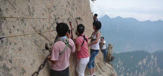
23. Tourists are photographed at the edge of the cliffs, against the background of the Carpathian firings far below.

24. Some Selfie is very dangerous - it is enough to make one wrong step on slippery stones to fly into a deep abyss ...

25. Local landscapes. The air is very clean and transparent.

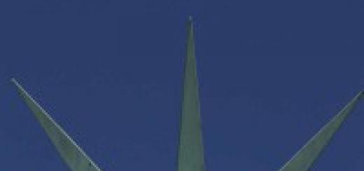
26. All above, and above ...

27. And above.

28. The most high-altitude sections of transfagara are located at an altitude of more than 2,000 meters above sea level. There are no trees here, around naked cliffs, places covered with moss.

29. Abandoned mountain camping:

30. We rise to the most high mountain. Below is visible to the LAP, leaving far beyond the horizon.

31. And on top - some semi-closed houses.

32. And the remains of the old funicular times of Ceausescu.

33. View S. mountain peak. Very nice!

34. Go away from the mountains in the Transylvania Valley. Transfagaras road ended)

Well, how do you track? Would we ride like this?
Update for October 2016: snow fell in the mountains, the highway is already closed.
The transfregarash mountain highway was built by order of the dictator Nicolae Causecu in the 70s of the last century, that is, about fifty years ago. On the this moment It is the second in height of a mountain road in Romania after the Transalpian Road (TranSalpina) and is among the top ten. The highest point on the track reaches 2024 meters. The highway crosses the Mountain Array of Fagarash, hence the name TRANSFăgărăşan, DN7C (or as sometimes written, transfagara).
The initial goal was to use the road for military purposes, but this undertaking, like many of the arrows, Ceausescu, did not justify himself. Not only that the construction of a bunch of people died during construction, it turned out that it was too expensive to contain it, since snow collapsions are often snowing. Therefore, as a result, the route is open from June 30 to November 1, dates may vary depending on the weather. In winter, the road looks like this:
 via.
via.
What to pay attention to:
- throughout the route there is no refill.
- there are stalls and cafes in two places: Lake Friell, and the dam Vrach
- the road is open only from 8:00 to 21:00, so you should not drive after 18:00, in order not to leave after the closure, in complete darkness.
Of the interesting on the road you can also see from north to south:
Cascada Bâlea- From him, there is a funicular to the lake, it is worth racing for an adult, 15 per child, one way.
Lake Lacul Bâlea - Picturesque lake at an altitude of 2 more than a kilometer. On the lake there are a couple of hotels and "Pances", a restaurant of middle lobby. But beautiful.
Peak Moldovan (Vârful Moldoveanu) - The highest point of Romania, 2544 meters. There is a non-slip, and, as far as I understand, not the simplest track from the Lake Friend - and you are the conqueror of the vertex.

via.
Cascada Capra (Cascada Capra) - Located right on the road, do not miss.
Cotton Poienari (Cetatea Poienari), Aka is real - for the most part of the ruins, but, if on the way, then why not climb. In addition, it opens with it a good look. ![]()

Vidraru (Vidraru) - Hydroelectric power station and lake, resulting from the construction of a huge dance in the form of an arch, 166 meters high.
13.09.2014
TransfaRaran - extraordinary beauty and danger
Alpine transfaRaRaran route - One of the most amazing and dangerous roads in the world. Another of its name transfirerash highway Or transfregareshhan she runs through the Romanian Carpathians and the Mountain Array of Fagarash. The highway connects two areas: valahius and transylvania, and rises up 2034 meters.

The length of the route is about 151km. TransfaRaran extends from north to south, there are the highest in the southern carpathians. The track begins in the city of Pitesti in Valahia, further stretches along the picturesque valley along the Argesh River, passing through the town of Kurta-de Argesh. Having reached the highest point, the road descends along the Olta Valley, and ends in the commune of Arpash de Jos.
A lot of sharp corners, steep turns, winding roads and sharp cliffs are forced to be nervous even experienced cyclists and motorcyclists, what to talk about motorists. In the Northern District there is an impressive part of the route - very dangerous turns and cool zigzag descents are concentrated there. The route is open only from July to October. Then it is closed, and the fare is blocked by concrete blocks. Under adverse weather conditions, the transfregarash highway can overlap before. In addition, driving on the highway is allowed only during the day. At the highest point is the longest tunnel in the country, with a length of 875 meters. Traveling through this highway, tourists can visit roadside restaurants and stay to relax in the hotel.
TransfaRaran was built four years, from 1970s to 1974, by order Nicolae Ceausecu for military needs. Such actions provoked the reaction of the Czechoslovakian government for the invasion of the Department of Internal Affairs (organization of the countries of the Warsaw Agreement) into the territory of the country in 1968. Nikolae Ceushestka, then the Secretary General of the Central Committee of the RCP, wanted to ensure the rapid movement of the armed forces through the mountains in the event of a re-attack. To perform work in the shortest possible time, the road was built with great financial costs.
To pave the track on the north side, I had to blow up part of the surrounding mountains - for this we used about 6,000,000 kg of dynamite. Did not cost and without human victims: According to official documents, 40 soldiers were killed during the construction of accidents.
Today, the transfregarash highway is the most beautiful road In the world, the business card of Romania. In its surroundings are different attractions Romania: Mountain Lake Byll and Waterfall, Fortress of the Pileari and the famous residence of Count Dracula. Once here Romanian Prince Vlad III, which is considered the prototype of the famous vampire. On the northern part of the route spend annual cycling competition Tour de Romania. This room gap is compared with the Tour de France highway, where world-famous cycling.


 The views around the luxurious, overlooking the Valley of serpentine, similar to a racing track. However, it is not possible to stop and enjoy them everywhere. The road is close, and the sidebuins and parking lots are rare. Besides terrestrial transport, At the top of the track you can climb along the cable car.
 In 2009, the leading Top Gear programs were tested on this road, and its presenter Jeremy Clarkson called TransfaRaran ideal for riding a sports car. However, when driving along the transfregash highway, it should be remembered: it is forbidden to be prohibited especially to accelerate here. The maximum permissible speed is 40 km / h.
Leaving, we already mentally drove into Belarus. Nevertheless, we still stood one mandatory goal in Romania - the transfregarash highway. This legendary narrow road is open to the end-to-end passage of a few more than two months a year and some "authoritative publications" are recognized as one of the most beautiful roads in the world. For incomplete 40 years of existence, she managed to become one of Romanian business cards.
Throwing back all the snobbery and I can say that the road and the surrounding nature really shock. For the day, we became children, with the open mouths, the glance around and not shy loudly and enthusiastically express emotions. Below is an attempt to transfer the admiration that we experienced overcoming these 150 kilometers.
1. In the network of Romanian roads, the transfehrashn has the designation "7C". If you go from Bucharest, it starts from the city of Pitesti. The first 30 kilometers run along ordinary flat-steppe Romania, along the poor Romanian and Gypsy villages. Coating on the entire average high-level highway: there are pits, cracks and irregularities. All this together on the first plot from Pitesti gave the soil for sarcasm about the "one of the most beautiful roads in the world." Subsequently, sarcasm quickly disappeared.
The only city on the highway - Kurta de Azhridge - looks very good for the Romanian "district center". Jokes jokes, and once Kurta de Argesh was the capital of the Principality of Valahia. By and large, the city is the border, after which the transfregash trail itself begins in its original understanding.
In the photo - the royal church of St. Nicholas in Kurta-de Argesh (Biserica Domnească Din Curtea de Argeş). The construction of 1352 years is made in the form of a "Greek Cross". It has a high value as a vivid example of medieval Romanian architecture, painting is even more valuable inside: 
2. Immediately for Kuta-de Azhgesh, rural civilization ends, there remains only an infrequent and cuneic tourist infrastructure and rare mountain villages located away from the road.
The route was built in 1970-1974 on the initiative of the dictator Nicolae Ceausescu (the very thing that she was half of the old city in Bucharest and built a giant in his place). 
3. Approximately kilometers of 10-20 from Kuza-de Azhzha, we began to calute from the surrounding beauty, smile and convulsively photograph everything around. In principle, it would be possible to say that I could not go in vain.
At the sight of bridges and clamps ahead, at first it became a little nervous - we had to go there. On the distant cliff, two bridges are visible above the abyss approximate in the following photo. We look at them from the bottom up and see a decent height above the disconnection and the seeming harness of the design. Of course, inside the fear of height is wakewicked: 
4. Official reason Construction is considered the fear of Ceausescu to the Soviet invasion of Romania. After watching Russian tanks in Prague, he decided to cut the road through a powerful mountain passAllegedly for the unimpeded transformation of troops to Bucharest. Why - I, honestly, do not understand. The transfregarash route on both sides at a relatively short distance is duplicated much more passable, wide and affordable roads. And the distance she allows to overcome, little on the scale of the country. Maybe he assumed that bumping the main routes, stupid scoops will not get to the secret mountain road. Finally, the USSR attacks on Romania in the autumn-winter-spring period, the value of this road would have fallen immediately - a chance to catch it with impassable abruptly. 
5. After dry and hot flat Romania, which for us is over, in general, only in Kurta de Azhda, it is very cool in the mountains, just bliss. Here in moderation is cool, fresh and tasty air, there is a countless number of rivers and streams with transparent water. 
6. The material and labor costs for the construction of the route were not so titanic as to the construction of the Palace of Parliament, but still huge. 6000 tons of dynamite spent. Officially died about 40 people. Unofficially - only on the construction of the Romania dam lost about four hundred human lives. Most of the builders were military. 
7. Having drove a small, but very picturesque section of the lifting on the slopes of semi-chass rocks, we enter the tunnel. In the photo below, leaving the tunnel - on the left, in the rock. Imagine that we felt on the road, seeing the gigantic dam and the picturesque mountain lake. By the way, in the rope on the right, one more entry into the tunnel is visible - it is some kind of small mountain primer, branched from the transfregarash highway. Judging by some cards, she envelopes the lake from another shore. The road there is killed in the trash before the entrance to the tunnel, from which loaded foresoves were traveled a couple of times. Next time (and I want to return there) it will be necessary to try there to dry there: 
8. The dam was built in 1965 on the Argesh River for the generation of electricity, irrigation and preventing floods. HPP itself is under Earth and has a rated power of 220 W.
On a mountain, towering over the dam on the shore of the lake, a statue of Prometheus with a zipper in his hands, as a symbol of electricity conquest: 
9. As a result of the construction of the dam, the amazing beauty of Lake Viorara, stretching in the gorge between the mountains of 10 more than kilometers. The water in it is turquoise tint, the shores are green. Surprisingly, but we have an example of fascinating with your beauty natural facilitycreated by man's hands: 
10. I do not understand what was the strategic salt of this road, but the landmark of Ceausescu left the country is notable, at the level of the Egyptian pyramids.
On the highway they go quite slowly: people admire with beauty. By numbers of passing machines can be studied political map Europe - saw almost all. On the largest parking lots and viewing sites there is some kind of Babylon and the full friendship of peoples: the Italians asked them to photograph, with the Poles, they just stood on the mountains loved, the Germans are worst here all, and the Romanians sell them all. 
11. The road is at the bottom - the service highway, which takes place from the main kilometers 10 to the lake (bridge in photo 3) and going to the dam shorter, at the bottom. It ends at the foot of the dam, while we, passing the main, - stand upstairs: 
12. When we were on observation site Dam, went rain. We have not seen rainies for more than two weeks, from Kiev. Promoting in your pleasure, let's go further. In principle, we were satisfied and happy, the dams with the mountains were enough for ecstasy. If the track was over this place, we would still recognize it one of the most beautiful in the world and were remembered with pleasure. But the most interesting was still ahead.
After the dam, the track is long looping in the forest, gradually rising up. Here it is already beginning to lay the ears and a headache. Getting cold. At the same time, on the sides - the forest, and realize that you are on the slope can only coming out of the car and passing a few meters to the side. From the window of the car, this area looks not so interesting.
Then the road goes to the picturesque alpine straight: 
13. It is so fresh, good and comfortable that you want to stop and just be alone with nature. Even despite the fact that Romanians whose forced us to rush to Belarus instead of continuing fighting in Romania, managed to fade in garbage and this corner: 
14. Said is done. After a couple of kilometers there was a very cozy tourist complex at the foot of the mountains. Here I had to get warm things from the suitcase for the first time in a suitcase, lying folded from Moscow. Here we once again proved that Romanian cuisine is beautiful: 
15. Why is this place so wonderful? Little mountains in the world?
Well, firstly, the transfregarash highway makes it possible on its own (well, or on a rolling) car with comfort to rise to a height of 2034 meters, according to normal (according to our standards) road, with two strips throughout. Those. Here the mountains can see the most ordinary person, and not a prepared climber.
Secondly, these mountains are insanely picturesque, with a pair of just unique places.
Third, Romania, despite all my soldiers in, is a peaceful and civilized country. There are no wars and gangspolia.
Fourth, there is a minimum of service, good, but not expensive, European level. He does not shit nature, prices are not damped under the ceiling, but there is an opportunity to have a snack and relax with comfort.
Quiet and cozy mountain plot overcome. Because of the fog begins to peck over Mahina Range: 
16. The track takes its name from the Mountain Massif Fagaras, which she crosses. This section of the South Carpathians collected in itself highest peaks countries. The road crosses it in about the same distance of 5-15 kilometers from two of them: Moldovan Mountains (Moldoveanu) - the highest point of Romania - and it (Negoiu).
In the valley before the ridge, a real extravagania begins. In this huge space located on the wide mountain slopes, green meadows, littered with stones, and many water streams are observed. The road loops on the slopes, slowly leading us to the very top. While we rose, stopping hardly on every turn, fog to the valley. He, like us, moving up, catching up with us: 
17. The fog turned out to be faster: at first he closed her kinds down, where we came from, and then covered us: 
18. We walked along the paths in the fog, breathed a cool wet air, sat on the boulders, lowered their hands into the water of the mountain stream and listened to silence, interrupted by rare yields of other tourists. Feelings from this place remained some otherworldly, as if it were not on Earth: 
19. Water flows everywhere moving from top to bottom. Dozens of small streams flow on the stones of the valley, uniting and becoming river. Water flows mainly by gentle slopes, passing through special ditches under the roadbed: 
20. Maybe water and frankly sliding on the rocks: 
21. A separate topic is the animals found on the highlands. In addition to the donkey, with his head climbed into the car and because of this, he did not get into the focus in the photo, saw a horse. From "Hedgehog in Tuman", obviously: 
22. Piglets charming immensely. Ranged, stlicled, pretended to be dead (I do not know that they actually did lying without movement for a few minutes), bathed in the mud.
At the site, the road was stopped by a group of harsh on the species of Slovak bikers. Chmuri eyebrows, they were drunk with motorcycles, took the cameras and began to chase the pigs. One of the pigs in response, while swimming in the mud, laid out about the sparkling silencer of one of the bikes. 
23. Well, of course, the rams and sheep. There are hundreds of them here. Seen and in the distance, on the meadows, and right in front of the nose. All looked at them. Some psychologically unstable people began to bleat, imitating sheep, whose voices filled the entire valley: 
24. A huge flock at the maximum approximation: 
25. The shepherd in this case is not at all lonely - they coped with these herds in the mid-all, sending lamb streams to each other on the slope of the mountain: 
26. With all the apparent clumsiness, these guys on their hooves are amazingly healthy on almost vertical surfaces: 
27. The crown of the road is Tunnel Capra (named River and Lakes in close proximity). Here we throw a look at the southern slope of the ridge, cross the tunnel and leave already from the northern side. 
28. It is - highest point lifting. After the tunnel, the road is as picturesquely descends down. The border goes here historical regions Romania - Valahia and Transylvania.
Immediately after the tunnel, on the north side, a rather big bazaar spread out, on which they traded both Romanian crafts and snacks and every Chinese souvenir fuffer. Here are some guest houses. Behind the turn, on the plateau, there is ice Lake Ball (Bâlea) and the same waterfall. We did not know in advance about it and in the end did not arrive, although there were meters in ten from him. This monstrous omission once again hints at the fact that we will return to Romania: 
29. The time flew unnoticed. In the morning we left Bucharest, drove away from the strength of kilometers 250, and the day was already cloned to an end. From the oversuppression of impressions and the height of heights, the fatigue took over the body. We started the descent.
The fog turned out to be unexpectedly so thick that nothing became visible at all. Darkness came, as if the night sharply went down on the ground. We drove very slowly, focusing on fog lanterns ahead of the cars going. We have not yet known that for almost half of the descent from us, for a symbolic bump, there was the most real abyss: 
30. From the North, the Fagara Mountain Array ends sharply. Immediately after the descent, it becomes light and clearly, we leave for the plain, on the sides - the picturesque meadows, the mountains rise behind his back. We are heading to the Transylvanian city of Sibiu, about which I will tell in the next part. 
31. The visual difference between Valachia and Transylvania is huge. Having drove through the mountains, we seemed to be in another country. In transylvania relatively pure, a lot of quiet deserted villages, the temperature is comfortable for life, the roofs of the dark tiles.
We could not say goodbye to the mountains so quickly. We had another day. Sibiu had running around in the morning, we have rushed to the cape tunnel.
So, the next day we conquer the transfregarass highway. Before approaching Sibiu, the Transylvanian village of Krapidoara, living due to the delivery of houses to tourists: 
32. Deneke was clear. Lifting up, we fully enjoyed the views that were closed with fog. And at the same time they saw, along what kind of abyss we went, without suspecting it. 
33. Unlike the south side, it's a sharp one here - the fields of the mountain and villages are clearly visible from the slopes on the horizon: 
34. From the south side of winding forest gorges. Here, in clear weather, in front of us, large-scale natural greatness appeared in all its fantastic Glav: 
35. On the track there are many such fortifications-galleries in the places of possible stonepad and departure of rocks. It seems impossible to appear that the roof on thin legs keeps a piece of rock. When she is interesting, will fall apart? 
36. On the south side of the slope of the ridge, the rise is carried out almost in the same vertical plane. When driving on the highway here it seems that the coordinates of the car are changing only up-down, and on the horizontal projection it looks more like oscillations, because The road snake rises upstairs: 
37.
38. A very bright girl's type from some northern European family. Unfortunately, she, watching the rams, was not kept from the temptation, and also blocked, starting to imitate them: 
39. The road rises through the gorge between two parallel spurs, moving toward the tunnel, located at the top and in the middle, in the place where the spurs converge. For a guideline - removed from above: 
40. No photos, no words will not be passed. Need to see.
Doubt is that we are in vain leave from Romania, originated in Bucharest. On the transfregarash track, we understood this very clearly. But it was too late.
The next part about the city of Sibiu will be the final in the Romanian series.