This list contains brief information On passes located in the Caucasus Reserve. The eastern border of the reserve runs on watercourse r. Damhurt and r. Big Laba, and captures the territory of the Karachay-Cherkess Republic; South passes or on side springs, or by the main waterproof ridge within the Kasnodar Territory. The Western border is located on the Western and Northwest outskirts of the Lagonatic Plateau. In the north, the border is stretched along the systems of the rocky and advanced ridges.
This list was created on the basis of the previously published list of passes of the mountainous part of the Krasnodar Territory and the Republic of Adygea (Butvin I., Samoilenko A., 1997), taking into account the information and clarifications accumulated over the past decade.
This list provides information on 172 passes, and 71 Pass (i.e. the greatest number) It has a category of the difficulty "1a". These are simple for overcoming natural obstacles: the farts, rock and snow slopes of steepness up to 30 ° or gentle glaciers without cracks, or steep herbaceous slopes. At approaches to these passes, trails can occur. The simplest passes are non-projectile - presented in the "list" in the amount of 45. The number of "1B" passages - "2a" categories of difficulties is 43. These are simple and moderate areas (up to 45 °), where it is sometimes necessary to use special climbing equipment. Complex passages, "2b" - "3A" categories of difficulties are represented in an amount 13, which is only 7.5% of the total number of translates described.
Passages in the list are grouped along the local sites of large mountain ranges or their groups, according to the established tourist-climbing mountain lists, as well as depending on the absolute height. For each pass, the following data is given in the list: the sequence number inside the subarea; the name of the pass; height in meters above sea level (data is given or on toplocks, or by altimeter indications); The category of difficulty in the summer time and the nature of the mainly determining the difficulty of the passage of the plots (rocks, scree, ice, snow, grass, forest); Valley of rivers, lakes, glaciers who connect the passes. Notes is given additional Information: Personal information (who and when), geographical features, historical and toponymic information.
The following local sections are allocated in the "list":
(Lagonak Highlands, Fisht-Oshtenovsky Array).
(Array Array - Large Chura - Achishho, Massif of Tybga - Jameak - Chugush, Assar Rats- Vorobyva - Dzitaka - Urushten, Juga-Bambak arrays).
3. Massives of Thachi - Acheshbok.
4. Eastern part of the Caucasian Reserve (an array of pseashha, Celips-Aloous-Yatyrgvart arrays; Aisha Ridge; Array of rocky; Tsakhvu Ridge (Herzen); Cabdian mountain assembly; Massives Yuha-Damhurts: Imeretic mountain assembly; Range Aibginsky and Acetuksky).
5. Massives Magisho Jante.
Briefly consider each of them.
1. Northwest Caucasian Reserve
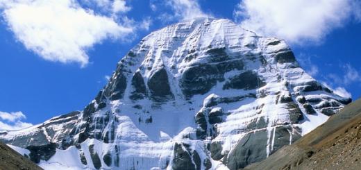
Lagonakian highlands it stands out in the system of the mountains of the Western Caucasus with a separate structure and adjoins from the north to the GKC in the area of \u200b\u200bBelorechensky Pass and Per. Higursan. Located in the passfold of the rivers of the White and Pzhahi. The boundaries are carried out on the cliffs of the Array Naughty-Chuk and the Chernogorier Plateau in the West, the rocky ledge of the ridges of the stone sea and the Asish Tau in the East; In the south, the border takes place on the passages of Guzeripl, Armenian and Belorechensky. Highest point Highlands - Mount Fisht (2868 m). The total area is about 700 km 2.
The Lagonak Highlands is a small rest of the vast media of a non-zealous country that once existed in the Caucasus. Modern surface is peculiar coasts caused by monoclinal location. Some of the passes (Maykop, gamean gates, etc.) are located in the locations of the limestone rock surface forming vertical walls.
South outskirts of Highlands borders a mountain group Fisht-Oshtenovsky massif . This building resembles a huge inaccessible fortress. The massifs of the Fisht Mountains and Pzekho-Sub are limited to almost all sides by scaling cliffs and huge glacial circuses. Slightly away from them there is an Oshtenovsky array, which with Mount Fisht connects to the jumper Fisht-Oshtenovsky Pass (2205 m).
In total, we have collected information on 15 passes, including 13 noncategories, 1 - 1-A, 1 -1-b K.T. Heights vary from 1463 m to 2675 m (Saddle of Oshthen).
Predated through some passes went shopping paths to the sea. In a pre-war time, the famous 30th All-Union Route "According to Adygea to the Black Sea" began to operate, which crossed the per. Guseriplsky (1965 m), Armenian (1852 m), Belorechensky (1782 m), Circassian (1836 m). A little later, the 825th All-Union Planning Route (Maikop Lazarevskoye) began to function, who began with a part of the T / B "Lagonaki" and then followed through the lane. AISH (1775 m), Abadzeshsky (2043 m), Oshtenovsky (2117 m), Maykopsky (1950 m), Chigursan (1889 m).
2. Western Caucasian Reserve
Massives Amuko - Large Chura - Achishho.Amuko Ridge with the same vertex of 1918 m is adjacent to the GKC from the southwest in the area of \u200b\u200bMount Large Chura. The length of the ridge from the west to the east is about 10 km. Classified 1 Amuko Pass with grass-oily slopes located in the southwestern shoulder of Mount Amuk and connecting the Agva River (Sochi River pool) and the ush (Sochi River pool). In the offseason estimated 1st K.T.
Massif Large Chira is in the axial zone of the main watershed and adjoins Khr.aamuko on the east. The highest point is Mount Large Chura (2250.7 m). The array has steep southern and western slopes, relative exceeds are up to 1000-1100 m. Above 2-kilometer isolated - open areas of the terrain. The Achishho massif also belongs to the GWC ridge system and towers from the North-West over the village. Red Polyany, the highest point - the Achishho mountain - 2391.4 m. From different sides to the array, scottographic or hunting trails are raised. In the "List" listed 4 pass, simple and affordable. The Achishho district is distinguished by what is considered the most wet place in the country. Clear, sunny days here are only 60-70 per year, and precipitation falls more than 4-4.5 thousand mm per year.
Massif of Tybga-jameroquo-chugush connects with an array of Achishho a wooded jumper Pass of the colchis gate. Located in the northern sorts of GKC. The highest point of the massif is Mount Chugush (3237.8 m). In our opinion, it is one of the most Western peaks-three-tales in the Caucasus. This is the real world of highlands with pointed peaks of cliffs, relatively powerful (by the standards of the Western Caucasus) mountain glaciation, large oily, snow slopes, "branch foreheads". It's hard to get here from the south, you need to spend 2.5 - 3 days from Krasnaya Polyana to get to the Chugushki glacier. From the north, from the village. Guzeripl to Tybga Mountain (3064.6 m) about 40 km of way. In total, 19 passes were passed and classified, the highest of which is K. Yu. Calval (2a, ~ 3060 m), the lowest - round (N / K, 2071 m), connecting the camp of the Sennaya with the village. Guzeripl. A large role in the development of this massif belongs to Maykop tourists-pedestrian. In honor of one of them, A. Kh. Baghova, the first master of sports on tourism in the Republic of Adygea, is called one of the passages.
Assar Ranges - Vorobyva - Dzitaku - Urushten located next to Yu-in from the Massival of Tybga-Gemachalo Chugush. If the 1st ridge is located in the axial zone of the GKC, then the rest are its northern extensions. This is the heart of the reserve and, moreover, is very hard to reach. Pass through this ridge lead, mainly from the Acipex River Basin to the Kish River Pool. The length of the ridge having a horseshoe form, 7-8 km. On the northern slopes in crosses are glaciers lie. They, in combination with rock-oily slopes, create certain difficulties when overcoming slides in the ridge. Passages here 2A-2B K.T. In xp Vorobyov is known 4 pass, the most difficult of them is 2a. In the upper reaches of the Chinese River, the right influx of the Kishi River, are located the lowest glaciers in the Caucasus, whose languages \u200b\u200bare lowered to 1710-1800 m. Through them are running to the vorobyev passes and eight. In xp Djitaka is one of the difficult-to-go tortured passages - camel (2690 m), estimated by 3a k.t. It connects the origins of the river of the Chinese and the bass. River Laura. The main difficulty is to overcome the 150-meter rock ice reset from the northern side and the increased slope of the slopes due to the strongly destroyed rocks. Some of the passages in this part were first passed and described in a scientific and sports expedition " Caucasian Reserve-94, one of whose leaders was the author. Among them: Syerchechensky (2a, 2750 m, IC. / LD. / OS), superior (1B-2a, 2682 m), oxid (1A-1B, 2405 m, herbs / OS / SK.) - In the ridge Dsitaka; Koshkarev is false. (1B, 2740 m, SC. \u200b\u200b/ OS / herbs.) In XP. Urushten.
North of the above jug Mountain Knot - Bambak . From the south, he borders on the lane, from the north of the salt ridge, the Western border passes along the Valley of the River Kish, Eastern - Dol. River Urushten. The highest point is Mount Juga (2975.9 m). On the northern slopes of Jugs, there are several small glaciers. The node is well-discovered protected trails from Cordon "Kish" through the lane. Aspid and with lane. Damn gates. In total, 7 unearned passages are planned, including three 1A K.T. And three n / k.
3. Arrays of Thachi Acheshbok
Thachi Ridge - Acheshbok - Chest located in the system of the foreground mountains at the border of the Caucasian Reserve. Relief Caetestical, Northern slopes, mainly grassy, \u200b\u200bcool (up to 40-45 °), orientation slopes are 150-250-meter rock bastions. On the ridge ridge, a well-stuffed path is followed. Total is known 5 N / to Pozals with heights of 1951-2150 m.
4. Eastern part of the Caucasian Reserve
An array of pseashha Really well studied by climbers, tourists, scientists because of their availability. From the Red Polyana for 1.5-2 days you can reach the camp "Cold" (Valley of the Urusten River) and in the upperwear of Malaya Laba. From here to the vertices and hand to hand. The western border of the array passes at a low decrease in the main watershed, separating the basins of the Urusten and Laura rivers. This is Pseashha's pass (N / K, 2014 m). Back in 1845, the Russian officer Baron Tornau penetrates through it from the Valley of the Urusten River in Red Polyana. He later wrote: "This plain inconspicuously leaning on the one hand to the northeast, on the other to the southwest, formed a fracture of the area." Pass, as noted in his wonderful book "The trails of the Mountain Black Sea" Yu.K.Fremov, really outstanding. It is a valley type. You can half a day go to the saddle and think about yourself: "When, finally, come?" So here the translated point lies on barely prominent bulge of the bottom of the Flat Valley.
The Pseashha array is highlighted by its compactness, pointed peaks, by local standards, a powerful glaciation (submitted by V.D. Panov, the Perezakho area is 1.8 km 2, and the length is 3.1 km). 10 passes were investigated here, except for the above-described simple lane. Pseashha is pen. Builders (1b, 2800 m), per. Oilman (1b, 2940 m), per. Marble (1B *, 2800 m) and others. To the first two on the part of the river, the clean way often runs through the cold glacier, one of the most extended in the edge. The marble pass presents an increased danger during rains (again from the river is clean).
Celips-Aloous-Yatyrgvart arrays Very picturesque, but extremely rarely visited by people. The highest point is the Mountain Chelips (3097 m). The Aloous Ridge, meridionally elongated from the south to the north, shares the pools of the Achipsa and Chelips rivers, there are practically no trails on it. In the array passed 15 passes, of which one of the most complex - per. Chelips Zap. (2a, 2811 m). Through per. Aloous and Mastacan in the war years passed a line of defense, and in the 60s and 1970s there was a planned tourist trail. Pass three (N / K, 2330 m), connecting an array of Yatyrgvart and XP. Skird, is a classic example of the fact that the saddle is slightly lower than the altitude mark of the pass.
Ridge Aisha - This is a plot of GKC from the passage of Ayishha to the pass of five. This is a long (about 30 km) and on the form of a gentle chain of meadow vertices, between which the shallow decreases of Sadlovin are settled. The ridge passes a holotopan trail. There are 5 handles N / K - 1-C.T., heights are within 1965-2625 m.
Certain interest represents tsakhvo Ridge (Herzen) - Water disposal between the rivers of Damhurtz and Tsakhvoa, located in the Northern Ochogogo of the Main Ridge, adjacent to him in the area of \u200b\u200bthe Mountains of the Tsyddyshha (3139 m) and having a length of 16 km. The highest point of the ridge - Mount Tsakhvoa (3345.2 m) This vertex is considered the highest point of the Krasnodar Territory. There are several more vertices exceeding 3100-3200 m above sea level. The slopes of the ridge are very steep, and places are placed, dismembered by deep crushing valleys, streams and prominers. The valleys of the tributaries of the Nameless and Thawa rivers form the riglels through which it is very difficult to increase. A total of 12 passes from 1a to 3a kt were passed in the ridge.
Relatively well studied Cardywach Mountain Knot - Famous tourist-climbing area. 18 passes were mastered, including N / K -3, 1A - 12, 1B - 2, 2A - 1. Maximum height - 2850 m, the lowest mark is 2100 m.
Imereti mountain node For a long time, he remained a little studied and deaf area of \u200b\u200bthe reserve. However, over the past decades, the situation has changed, and 16 passes from N / K to 2B K.T
Range Aibginsky and Acetuksky combined into one subarea. The length of its 35 km, the highest point - the Mount of Agepsta (3257 m), has a general-standard stretcher and stretches to the south of the GCC, separated by the Mzymti valley. 10 passages of various categories of complexity were sent: from N / K to 1B K.T., the height of the pass oscillates from 1500 to 2600 m.
5. Massives Magisho and Gant
Magisho Mountain Knot - Gense Located partially on the border with the Republic of Karachay-Cherkessia. The highest point is Mount Magisho (3160 m). On the side of the Valley of the River Laba - good transport entrances. Through the depths of Umpir, Magisho has long been passing and tourist trails. Alpine meadows are natural pastures for livestock: horses, sheep.
Legend and abbreviations
1953,9
Accurate high-rise mark
1950
Approximate altitude mark
~2600
Approximate altitude mark
(Zero picket)or / Ur. Agepsta / the name is usually equivalent
(bass. r. white) Explanation of the location of the object
[Dzishsky] historical name (toponym)
"Flumbing" Rarely consumable toponym
[?]
no accurate localization toponym
FROM - north Z. - West, YU- South, IN - East
sowing. - North, Zap. - Western, south. - South, vost. - East
gL - the main one [], centre. - central [], knot. - nodal [-th] B. - big [-th], M. - Small [-th] top. - Upper [-YE], nizhn. - Nizhny [-YE] right. - right [], a lion. - left [],
per. - Pass, ice. - Glacier [Ice. № 21
- Glacier number on "Catalog of glaciers ..."] g. - Mountain, in. - Top, P. - peak, xp - Range, GWH - The main waterproof ridge
oz. - Lake, R. - River, hand. - Creek, d. r. - River Valley, bass. R. - River pool
ur. - Urochische
Conditional cuts in the difficulty of passages
herbs, (Tr.) grassy
sC. Skal
oS. Outdoor
forest. forest
lD. Ice
cH snow
n / k. Not categorical
Note: All heights and bindings are given on topo-volume scale M 1: 25000
All cards open in large size (2-3MB)
Navigation on the article:
Lagonas, Fisht-Oshtenovsky array
| № | Name | Height | Category | Location | Intelligence |
|---|---|---|---|---|---|
| 1 | Abadzeshsky | 2043 | n / K., herbs. | between an array of Abadzesh and XP. Stone sea origins p. Kurdzhips - origins p. Armenianki (instructor gap) | |
| 2 | AISH [DZISHSKIY] | 1775 | n / kforest. | between xp Stone Sea and Plateau Iron, ur. Groit (bass. R. Bzically) - bass. R. Kurdjips. | |
| 3 | Armenian | 1866 | n / K., herbs. | between the array of Oshthen and XP. Armenian, origins p. Muddy warm-up - origins p. White (shelter FishT) | |
| 4 | Belorechensky [Square, Shitlib] | 1782 | n / K., herbs. | GVC, between the Array of Phys and the city of Belorechenskaya 1972.0, origins p. White (shelter FishT) - origins p. Bust (bass. R. Shahe) | Ancient trading and scratoproprogon trail for the message of the mountain tribes, having lived on the sea coast and on the northern slope of the GKC. |
| 5 | Gamean gate"Instructrial gap" | 2020 | n / kcable. | sev - Vost. The tip of the Oshthen array, to the h and near the cliff (2045.0), a lion. source r. Armenianks (instructor gap) - right. source r. Armenianki (ur. Uzoror's pass) | Through the "Gate" trail with a plateau of the lagons to the lanegizeripl and further on the PRTT |
| 6 | Guzeriplsky (Guzeripl) | 1995 | n / kcable. | between the array of Oshthen and G. Guzeripl 2158.0, origins p. Armenians - origins p. Muddy warmly | |
| 7 | Maykopsky | 1950 | n / kcable. | between the array of pchaho-su and xp. Nagya - Chuk / g. Tuba /, bass. R. CITICS (OZ. Psens or Ur. Cup) - bass. R. Pchahi | |
| 8 | Meso | 1950 | n / K., herbs. | between the Mesosso array (2070,5) and the Array of Naked - Chuk (2371,5), r. Firing / ur. Cold Rodnik / (bass. R. Citz) - origins p. Second hype (bass. P. Pchach) | |
| 9 | Oshtenovsky | 2117 | n / K., herbs. | between the arrays of Abadzesh and Oshten [p. Natalie - 2279,0], origins p. Armenianks (instructor gap) - origins of r. Citz (ur. Lagonas) | |
| 10 | Saddle Oshten | 2675 | 1atr.-as.-CHN | array of Oshthen, between in. 2761.0 and Oshten Center. (2727.8), origins p. Citz (tract of lagons) - origins of p. White | Penchukov A. - P / P (1988). |
| 11 | "Tubinsky" | 2025 | n / kcable. | between Tuba (2062.0) and XP. Nagy - Chuk (2467,1) | Tubinsky in the period of the Caucasian war was called the SCU. Per.Grachevsky. |
| 12 | Fishtinsky | 2442 | 1B, sn. - LD. - OS. | array of Phys, between the main vertex 2867.7 and the southern array (2564.5), ice. M. Fishtinsky (bass. R. White) - origins of p. Pshekhashchi (bass. R. Pzhah) | Samoilenko A. - P / P (1988). |
| 13 | Fisht-Oshtenovsky | 2205 | n / kcable. | between the arrays of Fisht-pchah-Soo and Oshten, oz. CITICS (bass. R. Citz) - origins p. White | |
| 14 | Circassian | 1836 | n / kherbs | south - Zap. Otrog GVC, between Chigursan 1951.0 and Mauritcuska 1953.9, right. source r. Busty - source r. Bushuika | |
| 15 | Chigursan | 1889 | n / K., herbs. | GVC, between the city of Chigursan 1951.0 and the Array of Physk (to the CERT from Per. Cherkessky), origins p. Pshashchi - right. source r. Beshe |
Amuko - Bol. Chura - Achishho

| № | Name | Height | Category | Location | Intelligence |
|---|---|---|---|---|---|
| 1 | Amuk. | 1780 | n / K., herbs. | array Massif, between the main vertex 1918.1 and c. 1846.8, r. AGVA (bass. R. Sochi) - r. Ush (bass. R. Sochi) | In the offseason 1a. |
| 2 | Achishho | 2220 | 1atr.-as.-CHN | GWH, between the city of Achishho (node) 2363.2 and c. 2253.6 (to in from the city of Achishho, the main. 2391,4), origins p. Fish (bass. R. Berezova) - origins of r. Achips (bass. Mzmitti) | Among local residents And Sochi local historians are common. The second name of the pass is "Sleep Circass." |
| 3 | COLCHIDE GATOR. | 1593 | n / kforest. | lowering in GVC, k from ur. Ottomans of the Balagan and near the bunch of "Grechko's house", r. Berezova (Bas.R. white) - r. TOO (BAS. R. Achips) | |
| 4 | Bear (bear gate) | 1880 | n / kforest.-Tert | xp Achishho, between in. "Center. Rocky" 2053.6 and c. 1999.5 a lion. source r. Rambers (bass. Mzmitti) - origins p. Achips (bass. Mzmitti) | |
| 5 | "Acute" | 1860 | n / kforest.-Tert | xp Achishho, 300 meters to the north-west of in. 1999.5 | |
| 6 | Chura | 2090 | 1atr.-as.-CHN | array of B. Chury, to the UZ and nearby. 2196,1, a lion. source r. Shah - source p. Sochi | |
| 7 | Chura Vost. | 2070 | 1atr.-as.-CHN | array of B. Chury, to from in. 2196,1 |
Tybga - Jameak - Chugush

| № | Name | Height | Category | Location | Intelligence |
|---|---|---|---|---|---|
| 1 | BAGAVSIY (Jamear) | 2800 | 1A., OS.-CH. | between the arrays of Chugush and Jamear (between the city of Calval 3095.8 and century. 2920.1), hand. BAGAVSIY (bass. R. Chesce) - r. Gemacard Vost. (bass. r. Kish) | Bugov A. (1971) - P / P, called the Piew "Jameak", Bugovyov I. (1974) when passing, gives the name "Bugovsky", in honor of Bagova A. Kh. |
| 2 | Side | ~2250 | 1B, SC.-OS. | northeast Spar of the vertex 2893.8 in the Kotov array, between in. in. 2659.1 and 2366.5, r. BAGOVY VOST (bass. r. Kishis) - Right influx of p. Kish | Luster V. (2002) |
| 3 | Calvary K.Yu. | ~3060 | 2A., SC.-OS.-CH. | massif Jamear, between G. Gl. (3157.6 m) and nodal in. (? m), origins p. Cold / Glacier №14 / (bass. R. Kish) - r. Jamear / Glacier №10 / (bass. R. Chesce) | Luster V. (2002) is named after Geobotanik K.Yu. Calvary - one of the oldest researchers of the Caucasus Reserve, |
| 4 | Kalugina S.G. | ~2400 | 1A.tr.-sk.-os. | UZZ Solid Massive Mal. Sugush (3063), between V.V. 2703.0 and 2471.1, between the two rights. R. Berez | Luster V. (2000) is used in conjunction with per. Kotov. |
| 5 | Kotova A.V. | ~2575 | 3A.sC.-OS.-LD. | xp Chugush, between V.V. 2612.2 and 3032.0 (NWT - "The Western Three Timber" in the Caucasus), rights R. Berezovova - Lev. R. HSU (XP.Barier) | Luster V. (2000), named after A. V. Kotova - Zoologist of the Caucasus Reserve, tragically deceased under avalanche on the Asspal Range in 1970 |
| 6 | MOLERAP | ~2470 | ~ 1b., Tr.-OS.- SC. | xp Anhydrous, between Tybga 3064.6 and c. 2558.0, source r. Molchpy - d. R. Chesce | Bugov A. (1971), Bowls I. (1974) Radially during the traverse XP. Anhydrous. |
| 7 | Nemtseva A.S. | ~2430 | 2A., SC.-OS.-CH. | ridge Gemacaruk (Northeast Spar G. Jameak Vost. 3099.4), between in. in. 2821.0 and 2594.0, r. Cold - r. Kish | Luster V. (2002). Named in honor of Zoologist A. S. Nemtseva, a researcher of the Caucasus Reserve tragically deceased in 2001 |
| 8 | Robinson V.N. | ~3000 | 2B,sC.-OS.-LD. | array of Gemacard, between in. 2814 and nodal in. (? m), | There is no information about complete passage. Named in honor of Geology V. N. Robinson, who studied the geological structure of the Mountains of the Caucasus Reserve in 1920-1930. |
| 9 | Fish (deer) | 2182 | 1A.,cable. | xp Anhydrous, between in. in. [?] and 2512.0, fish beam (bass. r. Molchepy) - d. r. Chesce | |
| 10 | Transcaucasis - 93 ("Osmanov") | 2640 | 1B, SC.-OS.-LD. | GWC, between in. in. 2778.3 and 2673.0, ur. Ottomans of the Balagans (the origins of the river. Turmon / bass. R. Achips /) - origins of r. Kish | Solid A. (1993). Named in honor of the scientific and sports expedition "Transcaucas-93" (1993) Lust (2002) - named Per. "Asmans" |
| 11 | Tamre | 2071 | n / K., herbs. | sowing. The tip of the 2nd Otrog Tybgi (near Turn Balagan), r. Unnamed (bass. R. Kish) - Eternal beam (bass. R. Cold) | |
| 12 | Tybginsky | 2944 | ~ 1b., Tr.-OS.- SC. | xp Tybga, between Tybga 3064.6 and G. 1st Pyramid 3099.4, hand. Tibginsky (bass. R. Cold) - d. R. Chesce | Bugov A. (1971), Ballotov I. (1974) Radially during the traverse of the Tybginsky-Jemaceaorsky ridge. There is no complete passage. |
| 13 | Tibginsko - Jemaca | 2775 | 2A., SC.-OS.-CH. | at the junction of the Tybgi and Gemaruk arrays (the lowest point of the "Tibginsko - Jemacaw Saw"), oz. Tibginsky (bass. R. Cold) - r. Jameak (bass. R. Chesce) | Samoilenko A. (1994) |
| 14 | Comfortable | 2590 | 1A., Tr.-OS. - CH. | north-West Snorge Massif Kotov (3046.0 m), between marks 2688.8 and 2478.6. origins p. Chesce - hand. BAGOBSKY ZAP. (bass. r. Chesce) | Samoilenko A. (1991). It is used in a bundle with the passage of Chugushch. |
| 15 | Chesce | ~3030 | 3A., SC.-OS.-SN LD. | massif Jamear, between the city of Calval (3096 m) and G. Gl. (3157.6 m), r. Jameak (bass. R. Holsu) - r. BAGOVY VOST (bass. r. Kishi) | Luster V. (2002) |
| 16 | Chugushch Vost. (Snow White) | 2675 | 1A - 1B., SC.-OS.-SN LD. | between the Chughash (in. 3026.0 m) and the Kotov array (in. 2893.8 m), origins p. Chesce / ice. Chugushku center ./- origin p. Kishi (left inflow) | Samoilenko A. (1994) |
| 17 | Chugushk zap. | 2700 | 2a - 2B, SC.-OS.-LD. | xp Chugush, between V.3035.0 and in. 2970.9, r. M. Chesce / Ice. Chugush Zap. / (Bass. R. Chesce) - origins of r. Berezova (bass. P. White) | Butvin I. (1994) - 2a, from R.ShuSu on "Baransim Liba" Lust V. (1999) - 2B, on the glacier Zap.Chukush (BAS.R.SSU) |
| 18 | Chugushch south. ("Maykop students") | 2760 | 1A., SC.-OS.-CH. | xp Chugush, between in. in. 3094.0 and 2778.3, ur. Ottomans of the Balagans (the origins of the river. Birch / bass. R. White /) - origins of p. KISH (ice. № 18) | Tsukanov M. (1990) The most convenient descent to the origins of Chiši, to the Gugushch Vost glacier, is used when it is renewed on Schugush from the UR. Ottomans Balagans. |
| 19 | South - Tybginsky passage | 2960 | 1B, SC.-OS.-CH. | south. The tip of the Cybgi massif, to the SD from B. 2998.8, oz. Tibginsky (bass. R. Cold) - r. Jameak (bass. R. Chesce) | Butvin I. (1994) a pass appearance. It was regularly used in the transition from G.Tybga (Traverse Xp.Ttybga) to Bas.r.chesu, incl. Bugov A. (1971), Borotov, I. (1974). |
Assara - Vorobyva - Dzitaka

| № | Name | Height | Category | Location | Intelligence |
|---|---|---|---|---|---|
| 1 | 55 years old Sevstu (snow) | 2723 | 1B, OS.-CH. | sowing. Ozogog GVC, between in. 2840.2 and in. (~ 2780) (to SZ from Per. Vorobyova), | Sevastopol tourist club (2006). |
| 2 | Assera (semi-tray) | 2550 | 1A *,oS.-CHN. | GWC, between in. in. 2653.5 and 2563.8, r. Turverse (bass. R. Achips) - r. Sowing. Assar (bass. R. Kish) | On the southern slope, the trail is partially destroyed. |
| 3 | Assara Vost. | 2555 | 1A - 1B., OS.-LD.-CHN | GWC, between in. [~ 2600] (Array of Assears) and Geomorphologists 2665.1, r. Petrarch (bass. R. Achips) - r. Sowing. Assear / ice. № 20B / (bass. R. Kish ) | From the north there is an approach from the part of the part. Geomorphologists. |
| 4 | Bakkermanna | 2395 | 1A., OS.-TR.-CH. | northeast Schogh XR. Urushten, between in. in. 2545.0 and 2452.0, origins p. Bakemanmanki (bass. R. Urushten) - r. Blue (bass. R. Urushten) | |
| 5 | Camel | 2690 | 2B - 3A., SC.-LD. | GWC, between in. in. (~ 2690) and 2707.5, origins p. Chinese (ice. №23) (bass. R. Kishis) - r. Laura Dzitakovskaya (bass. R. Achips) | Tsukanov M. (1993). |
| 6 | Vorobyva V. I. | 2646 | 2a *,sK.-LD.-CHN | sowing. Sague GVC, between Vorobyva 2854.4 and c. 2840.2, hand. Geomorphologists (bass. R. Kish) - ice. Vorobyva / № 21 / (bass. R. China) | Vorobyov V. (1906). He died on the descent from the glacier when the passage of this pass towards the valley p. Chinese. IN AND. Vorobyov (1875-1906) is a geologist and mineralogue, which was standing at the origins of the geological study of the Caucasian Reserve. Opened Triassic sediments in the r. White and r. Mal. Laba. |
| 7 | Eight | 2392 | 2A., SC.-OS.-CH. | sowing. Ozogog GVC, between in. 2840.2 and in. 2568.5, (to St. Vorobyeva), Nikiforova Beams / Handle. Vasilyeva /) - ice. Vorobyva / No. 21 / (bass. R. Chinese) | Vasilyeva G. (1978). |
| 8 | Sad | 2535 | 1A., OS.-TR.-CH. | array of Urushten, between the city of sad (2763.9) and in. 2573.0, oz. Sad (bass r. Sad) - Lake on XP. Sad (bass. R. Chinese) | Andreev D., Andreeva A. (2012), passed from OZ. Sad (bass.r.gusteny) in the valley of r. Chinese. |
| 9 | Djitaka | 2700 | 1B, SC.-OS.-CH. | south. The tip of XP. Urushten (sowing. Outburn of GVC), between in. in. 2733.6 and 2663.0, origins p. Blue (bass r. Urushten) - d. R. Chinese (bass. R. Kish) | Bugov A. (1971), Borotamov I. (1979). |
| 10 | "HECHERS SHILES" | 2550 | 1A *, SC.-OS.-CH. | GVC, to St. And near the city of Assar 2632,1, origins p. Petrarki (bass. R. Laura) - origins of r. Sowing. Assar (bass. R. Kish) | Two saddles. Descent / lifting on the slope with a backpack is difficult. |
| 11 | Kashkareva I. | 2780 | 1B, SC.-OS.-TR. | xp Urushten, between in. in. 2808.3 and 2898.9, (to with from the lane. "Caschera is false."), d. r. Blue (bass. R. Urushten) - 2nd right. Inflow p. Chinese / ice. № 25 / (bass. R. Kishis) | Solid A., Charitynikov N., Butvin I. (1989). Aradial exit from the valley of the river. Blue. Named in honor of I. Kashkarev - Lioweda tourist who died under avalanche on the Kola Peninsula |
| 12 | Kashkareva I. "False" | 2740 | 1B, SC.-OS.-TR. | xp Urushten, between in. in. 2760.4 and 2808.3, (k from from per. Djitaka), d. r. Blue (bass. R. Urushten) - 1 right. Inflow p. Chinese (bass. R. Kish) | There is no information about complete passage. |
| 13 | Superior | 2682 | 1B - 2A., Tr.-SK. | xp Djitaka, between in. 2795 and Dzitaka 2818.5, | Used. In a bundle with per. Syerchechensky. |
| 14 | Bypass | 2665 | 1A.,cable. | sowing. Ozogog GVC, between in. (~ 2780) and 2687.0 (to the SZ from lane. Snow), Nikiforova Beams / Handle. Vasilyeva / (bass. R. Kish) - HREL. Geomorphologists (bass. R. Kish) | Butvin I. (1995). |
| 15 | Outdoor | 2405 | 1a - 1b,tr.-as.-b. | xp Djitaka, to St. Dzitaka, r. Blue - r. Urusten | There is no information about complete passage. |
| 16 | Schapovsky S. V. | ~2750 | ~ 1b - 2a, SC.-OS.-CH. | kVV from the city of Urushten 3020.6 (1st saddle), between Urushten 3020.6 and c. 2775.0, oz. Urusten (bass. P. Asspal) - r. Blue (bass. R. Urushten) | There is no information about complete passage. Named in honor of the profession of S. V. Schapovsky (1878-1945) - a famous ophthalmologist and traveler. |
| 17 | "Jumper" | 2500 | 1A - 1B., SC.-LD.-CH. | sowing. Sagan G. Geomorphologists 2665,1, the origins of the hand. Geomorphologists (bass. R. Santa. Assara) - ice. № 20B (bass. R. Sitting. Asissara) | Used in a bundle with the passage of Assar Vost. |
| 18 | Syerchechensky | 2750 | 2A., SC.-LD.-OS. | GWC, between in. in. 2817.2 (node) and 2795.7, ice. Djitaka / № 26 / (bass. R. Blue) - Dzitakia lakes (bass. R. Urushten) | To lakes, the descent through the pass is superior. |
| 19 | Urushten North. | 2930 | 1A - 1B., SC.-OS.-TR.-CH. | xp Urushten, K with and near the city of Urushten 3020.6, oz. Urushten (bass. R. Asspal) - 3rd rights. Inflow p. Chinese (bass. R. Kish) | Butvin I. (1995). |
| 20 | Urushten south. | 2830 | 1A - 1B., SC.-OS.-TR.-CH. | xp Urushten, between in. 2898.9 and urushten 3020.6, (k from from lane. Kashkatreva), d. r. Blue (bass. R. Urushten) - 3rd rights. Inflow p. Chinese (bass. R. Kish) | |
| 21 | Shaposhnikova H. G. | 2550 | 2B *, SC.-LD. | GWC, between in. in. (~ 2596) and 2633.7, origins p. Chinese / ice. №22 / (bass. R. Kishis) - r. Laura Assarian (bass. R. Achips) | Luster V. (1999). Named in honor of H. G. Shaposhnikova - founder and first director of the Caucasus Reserve. |
Juga - Bambak

| № | Name | Height | Category | Location | Intelligence |
|---|---|---|---|---|---|
| 1 | Aspidiform | 2315 | n / kherbs | between xp Aspid and juga array, r. TURN (bass. R. Kish) - r. ASPID (bass. R. Urushten) | |
| 2 | Bambakian | 2642 | 1A.,cable. | bambaca arrays and mines and small. Bambaca origins p. Bambuckers - origins p. Champs | Descent toward r. Champs are more convenient through the Chepsinsky Pass |
| 3 | JULY. | 2900 | 1B, SC.-OS.-CH. | massif Juga, to C and near the city of Juga 2975.9, r. Chelpers (Champsinsky Lakes) (bass. R. Urushten) - r. TURN (BAS.R. KISI) | Bondar V. (1994) |
| 4 | Prince | 2330 | n / kherbs | between the array is small. Bambak and XP. Solontsov r. Prince (bass. R. Kishi) - r. Bambachka (bass. R. Urushten) | |
| 5 | Salonian | 2345 | n / kherbs | xp Solonsky, between in. 2475.0 and Züvyv 2425.0, r. Bambachka (bass. R. Urushten) - Lion. Inflow p. Shishi (bass. R. Kishi) | |
| 6 | Chepsene | 2692 | 1A.,cable. | between jugs and small arrays. Bambaca mordovskaya beam (bass. r. Kishi) - r. Champs (bass. R. Urushten) | |
| 7 | Schilder V. A. | 2602 | 1A.,cable. | massif Juga, between in. in. 2681.0 and ~ 2730, oz. Jug (Kotova) - Per. Aspidiform | Lifting up by the passage of the gravity of the ridge. Named in honor of V. A. Schilder (1855-1925), participant and chronicle of the Kuban hunting in the period from 1893 to 1902. |
Thach - Acheshbok

| № | Name | Height | Category | Location | Intelligence |
|---|---|---|---|---|---|
| 1 | Asbestile ("Confectionery") | 2150 | n / kherbs | In south - zap. - Zap. shoulder and near the city of asbestos [Cherpedzhezh] 2285.3, origins p. Aphonks (bass. R. Shishi) - origins of r. Shishi (bass. R. Kishi) | |
| 2 | Acheshbok (damn gate) | 2120 | n / k Herbs | Between the damn gate (Acheshbok) 2486.0 and XP. Agiga R. Bol. Acheshbok (bass. R. Bugunzha) - origins p. Shishi (bass. R. Kishi) | |
| 3 | Ossetian | 2095 | n / kherbs | Between G. Mal. Thach 2237.9 and in. 2135.0, origins p. Aphonks (bass. R. Shishi) - origins of r. Thach (bass. R. Bugunja) | comb traverse in a scratoproprogon trail |
| 4 | Tkhachsky | 1951 | n / kherbs | Between G. Bol. Thach 2368,4 and G. Mal. Thach (bald) 2237.9, R. Bol. Sahrai (bass. R. White) - r. Thach (bass. R. Bugunja) | |
| 5 | Chert Kalita | 2066 | n / kcable. | Xp Agiga, K in and near. 2377.6, Dead beam (bass. R. Urushten) - bass. R. Acheshbok / Bugunja / |
An array of pseashha
| № | Name | Height | Category | Location | Intelligence |
|---|---|---|---|---|---|
| 1 | 75 years old KGPBZ | 3150 | 1B, SC.-SH.-OS. | GWC, an array of pseashha, between V.V. 2822,0 and 3065.2, r. Cold / Glacier №28 / (bass. R. Urushten) - First influx of p. PsLUM (bass. R. Mzymt) | Luster V. (1999) |
| 2 | Twin | ~2860 | 2A.sK.-OS.-CHN. | SZ Otrog Massif Pseashchha between Zubtsi Pseashho (2936.4) and G. SEV.Pseashha (3256.9), cold Glacier (bass.r.-sharp) - Marbled Glacier (bass.r.sholdy) | Luster V. (2002) |
| 3 | Zagorsky | ~2850 | 2BsK.-OS.-CHN. | northern Schogo GKC from B.3012.8 (Xr.Pseashha) between V.V. 3012.8 and 2937.9, glacier Marble / comm. Kholodnaya/ (bass.r.urushten) - R.Cheelipsey (BAS.R.UURUSHEN) | Luster V. (2002) |
| 4 | Marble | 2800 | 1B *, SC.-SH.-OS. | between North. Pseashha 3256.9 and in. 3012.8 (node), r. Pure (bass. R. M. Laba) - r. Cold (bass. R. Urushten) | The possibility of passing the pass was noted in 1936. Yu. K. Efremov. In 1965, the passage committed V. Marchenko. In the report for 1966 V. S. Weiser. The name "Pass Marble" is already mentioned. Especially popular was the marble in the early 70s, when various "tourists", "Schools", "Seminars" were held in the Pseashha district. |
| 5 | Marble-Imereti | 2740 | 1B, SC.-TR.-OS. | northern Otroga G.Mramorn, between V.V. Marble (2892,1) and 2783.0, r.Iimetina (Oz.Mramorn) - Cold Camp (bass. R. Yurushten) | Butvin I. (2011). It is passed radially from the side of the Raz.Maramorn on the rock and dumping sidelier. Exit to the crest above the pass. The descent in the grassy-crop circus in (Bass.R.Uerushten), the rise (traverse) on the SZZ Svzog B.2658.5 and the subsequent descent to the lag. The sharply visible and the "theoretically" does not represent complexity. |
| 6 | Oilmen (oilman) | 2940 | 1B,lD-SN.-S. | the inflection of the Pseashha's Plow Glacier, between B. in. 3164.4 and 3154.6, R. Muddy (bass. R. M. Laba) - r. Pure (bass. R. M. Laba) | Pass is called tourists of the Institute of Oil and Gas Industry and accurately until October 1980 (Source - Swiransky V.) |
| 7 | Pseashcha | 2014 | n / kherbs | GVC, between the city of the transferred 2634.3 and the massif of the pseashch r. Urushten - r. Pslum (bass. Mzmitti) | Tornau F. F. (1845). The old trade and scroll trail to know the Gorsky tribes that lived on the sea coast and the northern slope of the GKC. |
| 8 | Builders (Builder) | 2800 | 1B, LD.-OS.-CH. | GWC, between the city of South. Pseoashchha 3251,2 and Sugar PseShashha (sugar head) 3188.9, ice. Pseashha (r. Net) - "2 left inflow" p. Psluk. | Lego S. (1962). On some tourist schemes, the name "Southern Pseashho" was met for this pass. According to Efremova Yu. K. (1938), the pass called "TURY". |
| 9 | Timukhina N. T. | 2900 | 3A., SC.-OS.-SN LD. | GWC, an array of pseashch, between the city of Pseoashchki nodal (3196.0) and the nodal shoulder (3192.0), the origins of the first tributary r. Psluk (bass. Mzmitt) - origins of r. Pure (bass. R. Mal. Laba) | Luster V. (1999). Named in honor of N. Timukhina - then director of the Caucasus Reserve, who occupied this position from 1984 to 1999. |
| 10 | Wide | 2575 | 1A.,cable. | northern Schogo GKC from B.3012.8 (Xr.Pseashha) between V.V. 2631.0 and 2862.4, r.Iimetinka (Bass.R.Uurushten) - R. Chelipsey (Bass.R.Uurushten) | Butworn I., Mudrov P. (2011). It was traveled from the valley of R.Imeretics (comfortable animal trails) to the Valley of the R. Chelipsey (descent on steep herbaceous slopes - arbitrary). |
Chelips - Aloous - Yatyrgvart
| № | Name | Height | Category | Location | Intelligence |
|---|---|---|---|---|---|
| 1 | Aloous. | 1950 | n / kherbs | between Alosa (2953.7) and Yatyrgvart (2761,1), r. Aloous (bass. R. Urushten) - r. Achipsta (bass. R. M. Laba) | |
| 2 | Aloous Zap. | 2746 | 1A., SC.-OS | sowing. - Zap. "Hadzhibey" Schogh XR. Aloous, between in. 2919.9 (node) and G. Hadzhibay (2867.4), oz. Khodzhibiy / Hadzhibay / (bass. R. Urushten) - r. Chelips (bass. R. Urushten) | Lego S. (1962) - p / p. |
| 3 | Aloous south. ("300th anniversary of the Russian Fleet") | 2800 | 1A., SC.-OS | xp Aloous, between the city of Old Aloous (2982.3) and in. 2919.9, r. Cheerful (bass. R. Achipsa) - r. Chelips (bass. R. Urushten) | Lego S. (1962) - p / n from the valley of the r. Cheerful in the valley r. Chelips. Kazakov A. (1996) Not knowing about the pioneer, gives the second name - "Pass of the 300th anniversary of the Russian Fleet". |
| 4 | Achipsta (Chelips) | 2870 | 1A., CH.-OS.-TR. | xp Chelipsis, between in. in. 2995.2 (node) and 3037.7, r. Achipsta (bass. R. Urushten) - Lion. Inflow p. Pure (bass. R. M. Laba) | Buggov (1971) - radial climbing from turquoise lakes. Drugs S., Lentsov S. (1972) - P / P, gave the name "Chelips". Smolyakova V. (1973) gives the name "Achipsa". |
| 5 | Turquoise lakes | 2895 | 1A., SC.-OS.-CH. | xp Chelipsis, between in. 3037.7 and Celips (3097,2), r. Achipsta (ice. Chelips / No. 34 /) - r. Light (bass. R. M. Laba) | Ryabukhin A. (1994) |
| 6 | Thunderstorm | 2750 | 1acable. | xp Aloous, between in. in. 2902.6 and 2796.8, | Nikiforov M. (1996) - p / p from the d. R. Chelips in the d. R. Achipst. Named thunderstorms, since a strong thunderstorm found on the saddle |
| 7 | Dinknik N. I. | 2750 | 1acable. | xp Aloous, between in. in. 2827.2 and 2995.2, r. Chelips (bass. R. Urushten) - r. Achipsta (bass. R. M. Laba) | Transport A. (2012) - p / p. Named in honor of N. I. Dinnik (1847-1917) - a famous naturalist and traveler, a large connoisseur of the Caucasus. |
| 8 | Beautiful | 2789 | 2A-2B.sC. -N.-OS | xp Aloous, between in. in. 2995.2 ("nodal") and 2842.2, r.Cheelipsey (Bas.r. Yurushten) - R.Achipsta (Bas.R. Mal.laba) | Luster V. (2002) |
| 9 | Mastacan | 1963 | n / kherbs | between Mastacan (2250.3) and Yatyrgvart (2761,1), r. Aloous (bass. R. Urushten) - r. Mastek (bass. R. Urushten) | |
| 10 | "Lake" | 2886 | 1A., CH.-OS.-TR. | xp Aloous, between the city of Old Aloous (2982.3) and in. 2979, lake Quiet (bass. R. Achipsa) - r. Chelips (bass. R. Urushten) | Smolyakova V. (1973) in Krokov gives the name "Lake", but the pass itself does not pass. Andreev D. (2011) is happy. Lifting on grassy-fastened slopes from the side of Oz. Quiet. Bypassing snowfights and exit to the ridge above the pass. Slopes in the valley r. Chelips are predominantly fart. |
| 11 | "Window" | 2400 | n / K.,cable. | south. Skurn XP. Celips, between V.V. 2472.7 and 3037.7, r. Pure (bass. R. M. Laba) - r. Light (bass. R. M. Laba) | Used in a bundle with lane. Turquoise lakes |
| 12 | Sevengilk (gardener) | 2750 | 1A., SC.-OS.-CH. | xp Chelips, between Celips (3097.2) and in. 2816.7, r. Achipsta (bass. R. M. Laba) - r. Sevengilk (bass. R. M. Laba) | Luster V. (year?) |
| 13 | Thji. | 2330 | n / kherbs | between Yatyrgvart (2761.1) and XP. Skird, r. Mastek (bass. R. Urushten) - r. T3 (bass. R. Urushten) | |
| 14 | Chelips Vost. | 2714 | 1A., CH.-OS.-TR. | xp Aloous, between in. in. 2842.2 and 2824.9, r. Chelips (bass. R. Urushten) - r. Achipsta (bass. R. M. Laba) | Smolyakova V. (1973) - p / n from the valley of the river. Celips in the valley r. Achipsa. |
| 15 | Chelips Zap. | 2811 | 2A., SC.-OS.-LD. | xp Chelipsis, between in. in. 2995.2 (node) and 3010.7, origins p. Chelips (ice. No. 33) (bass. R. Urushten) - r. Pure (bass. R. M. Laba) | Bugov A. (1971) - p / p from the valley of the river. Chelips in the valley of the R. Tile; Gives the name "Chels". Asmoljakova V. (1973) gives the name "Western Chelips", although the pass himself does not pass. Lusto V. (1998) gives the name of the Pope Pope and determines the complexity as 2B. |
Array of rocky, Ridge Aisha and Ridge Tsakhvoa (Herzen)
| № | Name | Height | Category | Location | Intelligence |
|---|---|---|---|---|---|
| 1 | Corgo | 2840 | ~ 1A-1B, OS.-SC.-TR | between c. 3085.5 ("rocky nodal") and B.2853.1, right source r. Mal. Laba / r. Aisha I / - Oz.korgo (Bas.r.Besyanki) | Butvin I., Pennixuk A., Ryabukhin A. (1999). Named in honor of the Krasnodar branch of the Russian geographical circuit. |
| 2 | Rocky | 2918 | ~ 1b,oS.-SC.-CH | between V.V. 3014.7 and 3085.5 ("rocky nodal"), right source p. Mal. Laba / r. Aisha I / - r. Serebryanka (Bas.r. Mal.Laba) | There is no information about complete passage. |
| 3 | 4 (four) | 2545 | 1A.,cable. | GVC, between Aisha (Aisha II) 2856.9 and c. 2822,4, R. Aisha (r. Aisha II) (bass. R. Slessiaba) - Ur. Aisha 2nd (bass. R. Mzymti) | |
| 4 | 5 (five) | 2592 | 1A.,cable. | GWC, between in. in. 2720.4 and 2833.5, a lion. source r. Unzyensea - r. Pinshnka / Brown / (Bas.R. Mzymta) | Maslikov V., Medvedev O. (1961). |
| 5 | Aisha | 2401 | n / kherbs | GWC, between in. 2619.3 and c. 2704.8, left source r. M. Laba - r. Pslushonok. | |
| 6 | Aisha II. | 1965 | n / kherbs | xp Pears r. Pslushonok (cord. Pslum) - p. Mzymt (Engelmanova Polyana) | |
| 7 | Flock | 2625 | 1A.,cable. | GWC, between in. in. 2822.4 and 2834.0 (near the lake. Klumbochka), r. Tornau / r. Aisha III / (bass. R. Slessiaba) - Ur. Aisha 3rd (bass. R. Mzymti) | |
| 8 | Borchevsky S. I. Zap. ("false") | ~3100 | 3A.sK.-LD.-OS. | between c. ~ 3170 (Bolchevsky False. ") And Burchevsky (~ 3240), glacier №43a / comm. Beshane/ BAS.R.ZHVOA– r. Opening (BAS.R.Besimyanka) | Luster V. (1998) |
| 9 | Borshevsky S. I. | 3220 | ~ 2a-2b, SC.-LD.-OS. | between Borchevsky (~ 3240) and Grigor, 3232.6, r. Opening (BAS.R.Besyanki) - R. Beshane (BAS.R. SHVOVA) | Solid A., Charitynikov N., Butvin I. (1989) during the traverse Khr.zakhvo (Herzen) from Per.grigor to Burchevsky. Named in honor of S. and, Borchevsky - one of the active initiators of the creation in 1896 Olo. There is no action on the full passage "from the valley in the valley". |
| 10 | Grigor G. G. | 3150 | ~ 2a-2b, SC.-LD.-OS. | between Grigor 3232.6 and c. 3176,1, R. Grigora / OZ-RA Grigor / (Bas.r.Beszyanki) - R. Beshabnoye (BAS.R.ZHVAO) | Solid A., Charitynikov N., Butvin I. (1989) during the traverse Khr.zakhvo (Herzen) from Per.grigor by Grchevsky, Luster V. (1999) - "Classical" First to lakes from the origins of R. Grigor. Named in honor of G. G. Grigor (1884-1960) - geologist, glaciologist, Lierada, who was standing at the origins of the Caucasian Reserve. |
| 11 | Turkey south. | ~2730 | ~ 1A-1B, SC.-SH.-OS. | between solid peak (3290,5) and Kindyuk (2944,1), closer to Jindyuk, rights. R. Lytnikova (Bas.R. Lamb) - R. Sumaschedeshest (BAS.R.ZHVOVA) | Butvin I., Bathur V., Glazyev N. (2009), Radial access to the pass with the ascent on the city of Jinyuk from BAS.R. Delated, there is no information about the full passage of the pass |
| 12 | Stone Fire (Tsakhvo) | 2995 | 1B, SC.-OS.-CH. | to the YOU from Tsakhvo (3345.9), between B.3251.1 and c. ~ 3130, r. Besheny (BAS.R. SHAVOE) - Rights. R. Beszyanki Protect ("R.Ulikka") | Ryabukhin A. (1996) - "Classic" passage from Tsakhvo in an uniagnosis. Lulusto V. (1999) called the "Tsakhvoa" pass during the passage from a flaw in the origins of the R. Beshemy (without descent in Tsakhvo). |
| 13 | Stone fire false | 3095 | ~ 1b *, SC.-OS.-CH. | in 0.5km. South of the lane (Tsakhvo) - between Uzl.V. ~ 3150 and in. ~ 3130, the neighboring circus to the bass, which rights R.Besyanki Protect ("R.Ulikka") - R. Beshabnoye (Bas.r.zakhvo) | Butworn I., Bathur V., Solovyanov A. (2008) The rise on the saddle of the pass Radially, from the glacier №43 - R. Sumaschedesh (Bass.R. Sakhvoa). In the direction of the "snail", the right influx of the uniaensione was viewed by a skewed rock and farthew "Turned" regiment. |
| 14 | Corgo II. | ~3145 | ~ 1b-2b, SC.-LD.-OS. | between Uzl.V.3290.7 and B.3251,1, 800m. north of Per.Kaman fire (Tsakhvo), rights. R. Wheelsyyanki ("Hand. Snail") - R. Sumaschedesh (BAS.R.ZHVAO) | Ryabukhin A. (2008), traverts from per.caman fire, through the vertex 3251.1, there is no information about full passage |
| 15 | Crown Tsakhvo. | ~3000 | ~ 2b., SC.-LD.-OS. | to St. Tsakhvoa (3345.9), between the peak of solid (3290.5) and the nod.v.3290,7, glacier №39 "Tsakhvo" /R.Lebovaya/ (Bas.r.m. Laba) - R. Sumaschedeshest (bass.r.zakhvo) | Ryabukhin A. (2009), radially on the part of the Tsakhvo Glacier (r. aladynikova), the mamorial plate is installed on the pass in memory of the solid A.V., there is no information about full passage |
| 16 | Steep | 2765 | 1A., OS.-CH. | between V.V. 2868.1 and 2881.5, the origins of R. Werezyyanki - R. Vorovskaya / Pooming beam / (bass.r.zakhvo) | Maslikov V., Medvedev O. (1963). |
| 17 | Nasimovich A.A. | ~2950 | 3A.sK.-LD.-OS. | between V.V. ~ 3170 (Bolchevsky false. ") And 3000.3, glacier №44 / comm.- r.VOROVSKAYA / Packaging beam / (bass.r.zakhvo) | Luster V. (2000), in honor of Nasimovich Andrei Alexandrovich - Biogeographer, ecologist, founder of snow ecology, no information about full passage |
| 18 | Pedestrian | 2980 | 1A., OS.-CH.-TR. | between c. 3142.1 and Borchevsky (~ 3240), r. Other (BAS.R.Besyanki) - R.Vorovskaya / Packaging Beach / (BAS.R. SHAVOE) | Maslikov V., Medvedev O. (1959). |
| 19 | Solid A. V. | ~2850 | ~ 1b-2a, SC.-LD.-OS. | between the peak of solid (3290.5) and the city of Jointuk (2944,1), closer to the peak of solid, glacier №41 / right. R. Lial / (Bas.r.m. Laba) - R. Sumaschedeshest (BAS.R.ZHVOVA) | Ryabukhin A (2009), radial access to the pass from BAS.R. Delated, there is no information about full passage. Named in honor of A. B, Slotid (1953-2009) - a talented geographer, local history and traveler. |
Cardywach Mountain Knot
| № | Name | Height | Category | Location | Intelligence |
|---|---|---|---|---|---|
| 1 | 13 (Cardiwach II) | 2800 | 1B, SK.-LD.-OS. | GWC, between Cardywach Knot. 2960.7 and Cardiwach Ch. (3058), ice. Cardywach / No. 46 / (bass.r.zakhvo) is right. source r. Avadhary | Medvedeva V. S. (1965) During the school of instructors of the Krasnodar Club of Tourists. |
| 2 | 13 false | 2830 | ~ 1b., SK.-LD.-OS. | sowing. Snoggy Cabdiwach Ch. (3058), ice. Cardywach / No. 46 / - Lion. Inflow p. Top. Tsakhvo. | |
| 3 | Avatharsky | 2750 | 1A., T.-E. | GWC, between in. 2806.5 and G. Adjara 2907.0, a lion. source r. Avadhara - Oz. Adjara (bass. R. Upper. Tsakhvo) | |
| 4 | Adjara Vost. | 2690 | 1A., T.-E. | GWH, between Adjara 2907.0 and c. 2744.2, | |
| 5 | Adjara Zap. (Tsakhvo) | 2670 | 1A., T.-E. | GWC, between in. in. 2744.2 and (node,), origins p. Top. Tsakhvo - bass. R. Lashipse | |
| 6 | Akhukdara | 2100 | n / ktr.-forest. | Akhukdar jumper, between Kutehek 2559.6 and Akhukdara 2303.6, r. Azmych (Bas.R. Mzymti) - r. Avadhara | Albov N. (1890) |
| 7 | Nine | 2801 | 1A., OS.-CHN | GWC, between in. 2839.2 and an array of Kyddyshha 3139.5, Lakes areted (bass. r. Upper. Mzimt) - Oz. INPSI (bass. R. Tsakhvo) | Marchenko G. (1966) |
| 8 | Cardywach (Cardywach i) | 2744 | 1A., OS.-LD.-CHN | GWC, between in. 2827.5 and Cabdiwach Knot. 2960.7, oz. Sineokoye (p. Sine-member) (Bas.R. Mzymti) - OZ. INPSI (handle. Transfer / Cardywach /) (bass. r. Tsakhvoa) | |
| 9 | Kuteheku I. | 2390 | n / kherbs | Akhukdar jumper, to the SMZ from the lane. Lake right. source r. Camp (Oz. Cardywach) - r. Avadhara | |
| 10 | Kutheku II. | 2450 | n / kherbs | Akhukdar jumper, to the SMZ from the lane. Kuteheki I, a lion. source r. Camp (Oz. Cardywach) - r. Avadhara | |
| 11 | Labinsky (Kuban) | 2745 | 1A., CH.-OS.-TER | GWH, between the city of Zap. Loyub (Kuban) 2941.4 and c. 2930.2, oz. Top. Cardiwach - r. Unimensional (bass. R. M. Laba) | Litvinov V. (1962) in the framework of the tourist and climbing extiring "Kuban" (head). During the climbing of the group, under the leadership of V. Litvinov, a tour was discovered from the note of students of MWU and tourism instructors from the Red Polyana, where it was said that the pass is called "Labinsky", but the climbers in honor of the expedition assigned to him the second name - "Kuban". |
| 12 | LOB. | 2700 | 1A., CH.-OS.-TER | southeast. GWC, between the city of South. Loyub (2998) and tourist 2848.6, oz. Cardiwach - Oz. Top. Cardywach | |
| 13 | Mzymt | 2850 | 2A., SK.-OS.-CHN | GWC, between in. 2930.2 and Northern Loyub 2950.1. oz. Top. Cabdiwach (bass. R. Upper Mzimti) and p. Unimensional (bass. R. M. Laba). | Luster V. (1999) |
| 14 | Lake ("Cabdian") | 2700 | ~ 1A., Os.-b. | Akhukdar jumper, in south - zap. Shoulder Cabdiwach Knot. 2960.7, oz. Sineokoe (r. Sine-member) (Bas.R. Mzimti) - Right. source r. Avadhara | Efremov Yu. K. (1936) |
| 15 | Smidovich P. G. | 2749 | 1A., OS.-CHN | GWC, between the array of acaragvart (Smidovich) 3140.4 and c. 2839.2, lakes areted (bass. r. Upper. Mzimti) - Northern Lakes (bass. R. Tsakhvo) | Within the framework of the tourist and climbing extiring "Kuban" under the leadership of V. Litvinova (1962). |
| 16 | Tourist (Krasnopolyansky, "3-fools") | 2815 | 1A-1B., SK.-S. | southeast. Ozogog GVC, between the city of Zap. Loyub (Kuban) 2941.4 and c. 2892.2, Oz. Top. Cardiwach - r. Pinshek / Ruffle / (bass. R. Mzymti) | Avakumanz S. (1962) within the framework of the tourist and climbing extiring "Kuban" under the leadership of V. Litvinova. Solid A., Charitynikov N., Butvin I. (1989) - Radial access to the pass during the passage of per. Labinsky. |
| 17 | Tsyddysha | 2745 | 1A., OS.-CHN | GWC, in the massif of the Kyddyshha between the vertices "south-east" 3091.5 and "small" 2924.5, oz. Cardywach (Bas.R. Mzymti) - Oz. INPSI (bass. R. Tsakhvo) | |
| 18 | Chernorechensky | 2655 | 1A., OS.-CHN | GWC, between in. in. 2676.8 and 2766.1, lakes Uthaen (bass. r. Verkhne. Mzimti) - r. Thief / baking / (bass. R. Tsakhvoa) | Within the framework of the tourist and climbing extiring "Kuban" under the leadership of V. Litvinova (1962). |
Lake Ridge, Imeretic Mountain Node and Shepsi Massif
| № | Name | Height | Category | Location | Intelligence |
|---|---|---|---|---|---|
| 1 | Ivchenko A. | 2850 | 1A., T.-E. | xp Lake, between in. 2892.8 and granite 3211.8, Poaching beam (bass. R. Tsakhvo) - r. M. Adjara (bass. R. Damhurtz) | Named in honor of the deceased tourist from the Abinsky district A. Ivchenko. |
| 2 | Stuntman | 3050 | 1B - 2A., SK.-LD.-OS. | IGU, between Bush 3119.6 and Geographers of Kuban 3212.0, oz. Bush (bass. R. Imeretics) - r. Unzyensea / Bright / (bass. R. Damhurtz) | Solid A. (1991) |
| 3 | Kom Svale. | 2570 | n / kherbs | xp Lake, between in. in. 2718.5 and 2699.2 (k from from per. Qua South.), | |
| 4 | Quate south. | 2470 | n / kherbs | xp Lake (sowing. Solid GWC), between in. in. 2802.0 and 2718.5, r. B. Ajara (bass. R. Damhurtz) - r. Top. Tsakhvo. | |
| 5 | Olo (Imereti) | 2930 | 1B - 2A., SK.-SN.-E. | IGU, between the city of Opozernoy and the city of Imereti spire 3189,4, oz. B. Imereti / Silence / (bass. R. Imeretics) - Right. The source of poaching beams / INPSI / (bass. r. Tsakhvo) | Solid A., Chardnikov N., Butvin I. (1989) From the side of the lake, the silence of the rise from the lower screeching to the rocky translated circus is carried out along a gentle herbal shelf. Expected snowfield-flight and the rock wall costs to the left in the course of the movement. The descent to the poaching beam is a grassy-felon slope of the average steepness. |
| 6 | Panoramic ("Kiev unemployed", "Marynsky") | 3100 | 1A - 1B., T.-E. | IGU, between in. 3135.4 and Tumanny 3251.2, oz. Big Imereti / Silence / (bass. R. Imeretics) - Warm lake (bass. R. Tsakhvo) | Smolyakova V. (1973) - Radial output from Oz. Silence. Shevrnogov V. (1990), Solid A., Merzheev K., Butvin I. (1991), Sokolov A. (2001) |
| 7 | Podfully | 3020 | 1B, SN- - | IGU, between Granite 3211.8 and Bush 3119.6, oz. Western (bass. R. Imeretics) - r. Unzyensea / Bright / (bass. R. Damhurtz) | |
| 8 | Rene | 3010 | 2a * - 2b, LD.-B.-CHN. | IGU, between the city of Granite 3211.8 and the city is superior, oz. B. Imereti / Silence / (bass. R. Imeretics) - Lion. The source of poaching beams / INPSI / (bass. r. Tsakhvo) | Samoilenko A. (1994). Under the supervised Rancuft rock belt. Lifting on the rocks of the lower the lowest jumper on inclined 50-60 degrees plate along the edge of the torn glacier with a yield of 75-85 degree 20 meter wall. Lust V. (1998) |
| 9 | Rybakova S. | 2890 | 1A - 1B., Os.-b. | south - Zap. Snorge G. Opozernoy, between G. Superior and B. 2942.4, right. and lion. The origins of the poaching beam (bass. r. Tsakhvo) | Akimchenkov G. (1994). Named in honor of Sergey Rybakov - Lioweda tourist from the city of Ababinsky Krasnodar Territory, tragically deceased in 1993 under the vertex lead. Pass passed by the group as part of the expedition "Caucasian Reserve-94" in August 1994 by the lake in the rightest source of the River Marière Beach. |
| 10 | Quiet | 3029 | 1A-1B., SK.-OS.-CHN | IGU, between Panova (3230.3) and in. 3129.3, the lake is quiet (bass. r. Imereti) - right. Inflow p. Bright / Unnamer / (bass. R. Damhurtz) | there is no information about complete passage |
| 11 | Difficult | 2850 | 1A., T.-SK.-E. | IGU, between in. 3009.4 and Olives 3029,4, oz. Black (bass. R. Imeretics) - Oz. Yu. K. Efremova (bass. R. Tsakhvo) | Maslikov V., Medvedev O. (1959) |
| 12 | Shepsy Sev. ("Instructors") | 2685 | 1A., T.-E. | xp Lake, between G. Shepsi (2819.3) and in. 2855.8, | Vorotntsev G. (1971), Pennixukov A. (1994) |
| 13 | Shepsy south. | 2690 | 1A., T.-E. | xp Lake, between G. Shepsi (2819.3) and in. 2750, hand. Shepsy Vost. (bass. r. Damhurtz) - HRR. Shepsi Zap. (bass. r. Tsakhvoa) | Penchukov A. (1994) |
| 14 | Chocolate | 2960 | 1A - 1B., SK.-OS.-CHN | IGU, between and G. geographers Kuban / g. Weax / Panova (3230,3), lake Bush (bass. r. Imeretics) - a lion. Inflow p. Bright / Unnamer / (bass. R. Damhurts) | Alaev. A (1967) makes a p / p, mistakenly takes this pass for the lane. Quote. Smolyakova V. (1973) performs passage of the pass from the valley of the river. Imeretics in the valley r. Damhurt and gives the name "chocolate". |
| 15 | Yuk | 2840 | 1A., T.-E. | ridge hay, between the city of Olives 3029.4 and c. 2870.0, oz. B. Yukhinskoe (bass. R. Yuha) - Oz. Efremova (bass. R. Tsakhvo) | Named A. Firm in honor of Yu. K. Efremova (1913-1999) - the famous local history, geographer, traveler .. |
| 16 | Yukhinsky (Yuha "Tourist") | 2875 | 1A., T.-E. | IGU, between the city of Olives 3029.4 and Safronova 2959.2, oz. B. Yukhinskoe (bass. R. Yuha) - Oz. Safronova (bass. R. Imereti) | Bocharov R. (1961) |
Massives Damhurts, Yuha, Magisho and Gent
| № | Name | Height | Category | Location | Intelligence | ||
|---|---|---|---|---|---|---|---|
| 1 | Fragrant | 2910 | 1A., T.-E. | xp Yuha, between Damhurts 3194.0 and c. 3162,5, hand. Aromatic (bass. R. Yuha) - lion. Inflow p. Imeretinka | Andreev D., Andreeva A. (2012), passed from the valley of the left tributary r. Imeretics in the valley of the creek fragrant. Approaches to the pass - grassy slopes of moderate steepness, stone scree. On the pass - Solonets, actively visited by hoofs. On the pass and close to it - a sharp and resistant smell of animals | ||
| 2 | Lugansky | 2428 | n / kherbs | jumper between XP. Yuha and XP. Lugan / g. Rock /, r. Upset (bass. R. B. Laba) - r. Luganka (bass. R. Small Laba) | Old scratoproprogon trail | ||
| 3 | Sysoeva V. M. (Yuha "Egerski") | 2916 | 1A., T.-E. | xp Yuha, between in. 2989.9 and in. 3020.2 (to C. from Per. Chusovoy), oz. Lugan / Per. Lugansk / (bass. R. Odan) - Right. Inflow p. Yuha (bass. R. Tsakhvo) | Named A. Firm in honor of Sysoeva V.M. (1864-19 ...?) Teacher, archaeologist, public figure, one of the founders of Olo, the first chairman of his rule. | ||
| 4 | Chusova | 2860 | 1A-1B., SK-TR-OS | xp Yuha, between the city of Chusovoy 3041.7 and c. 2989.9 (to SZ from Damhurz 3194.0, r. Chusovaya (bass. R. UKHAR) - Right. Inflow p. Yuha (bass. R. Tsakhvo) | |||
| 5 | Yuha-Lugan. | 2900 | 2A., SC.-OS.-TR | xp Yuha, between in. in. 2925.0 and 2958.0, right. Inflow p. Yuha (bass r. Tsakhvoa) - Verkhneelugan lakes (bass. R. Luganka) | Ustinovsky N. (2000) | ||
| 6 | Blybsky | 2568 | n / kherbs | jumper between XP. Magisho and XP. Gent, between in. 2854.0 and G. Granu 2911.0, r. Beaven - r. B. Blob | Old scratoproprogon trail | ||
| 7 | Volkova T. I. | 2805 | 1A., T.-E. | xp Sergeyev Guy (Vost. Tip), between in. in. 2859.6 and 2931,4, oz. Scott / Pine beam / (bass. R. M. Laba) - bass. R. Umpir | Solid A., Charitynikov N., Butvin I. (1989). Wide ral-grass saddle. Descent / lifting from Stor. d. r. Umpir is problematic. Named in honor of T. I. Volkova (1934-1987) - the oldest Kuban tourist - Lieraded, a worker of children's tourism. | ||
| 8 | Magisho ("South. Blybsky") | 2880 | n / kcable. | xp Magisho, between in. in. 3014.7 and 2928.4, r. B. Balb (bass. R. B. Laba) - r. Ukppy (bass. R. M. Laba) | Old scratoproprogon trail | ||
| 9 | MirShawko O. T. | 2830 | 1A., T.-E. | k in and near the lane. T. I. Volkovka, between in. in. 2931,4 and 2917.6 s. Scott / Pine beam / (bass. R. M. Laba) - origins of r. Beaven (bass. R. B. Laba) | Named in honor of MirShavko O.T. (1936-1989) - Methodist of the Leninsky House of Pioneers of Krasnodar, member of the GSK district, urban and regional tourist competitions of schoolchildren. | ||
| 10 | Ukpirsky | 2528 | n / kcable. | jumper between XP. Lugan / g. Rock / and xp. Magisho, r. Umpir / Duppie / (bass. R. M. Laba) - r. Upset (bass. R. B. Laba) | ~ 1A-1B, Os.-b. | zap. The tip of XP. Acetuk, between Albova 2951.4 and G. B. 2791.0, r. Silent (bass. R. Mzymt) - r. Acetuk (lake Ritsa) | |
| 3 | Acetuksky | 2150 | n / kcable | Ahukdar jumper, between acetuka array and Akhukdar 2303.6, R. Azmych (Bzych) - Oz. MZI (bass. Р. Мзимна) | |||
| 4 | Acetuksky Zap. (Survey) | 2460 | 1A - 1B., Os.-b. | xp Acetuk, between Acetuk [Ch.] 2769.2 and c. 2549.0, Acetuksky lakes (bass. R. Azmich) - r. Waterfall (dairy) / oz. Rice / | |||
| 5 | Hope | 2453 | 1A., T.-E. | massif Turin Mountains, between "Black Peak" (~ 2980) and in. 2848.2, r. Long (long river) / ur. Agepsta / - r. Blue | |||
| 6 | Superior (Blue) | ~2510 | ~ 1A., Tr.-OS ..- SK. | array of Turin Mountains, South Sadlovina Above Lake Blue, west of the top of 2585.6, lake Blue (bass. R. Mzymt) - the upper shovel of the left tributary r. Mzyms (r. Blue) | |||
| 7 | Horn | ~2600 | 1a * -1b.oS ..- SC.-TR. | massif Turin Mountains, between B.2681,5 and ~ 2740, rights. R. PSOU ("11th Balagan" / - r. Blue (bass. R. Mzymta) | Luster V. (2002) | ||
| 8 | Tour Galot. | 2580 | 1A., T.-CHN-E. | massif Turin Mountains, between in. in. (2651) and (2772) [node], origins p. PSOU (UR. Berchövka) / "11th Balagans" / - r. Blue (bass. R. Mzymti) | |||
| 9 | Angular | 2070 | n / K., forest.-tr. | xp Corner (Ur. Angle Agepstan), between in. in. 2277.0 and 2109.0, r. Azmych (Bzych) / Ur. Yashenko / - r. Quiet (fabulous glade) | |||
| 10 | Circassian | 2430 | n / kherbs | xp Far Aibgie, between Green (Green Wedge) 2547.2, and in. 2681.5, origins p. PSOU (UR. Berchövka) / "11th Balagans" / - r. Green (bass. R. Mzymti) |
Literature
- Abdeshev Yu. N., Kolomiets A. M. Tourist trails. - Krasnodar, 1957
- Akimchenkov G. F. Report on the Mountain Tourist Travel 3 categories of complexity. (Expedition materials "Caucasian Reserve"). - Krasnodar, 1994
- Albov N. M. Report on Botanical studies of Abkhazia for 1890 // Notes of the Caucasian Department of the Imperial Russian Geographical Society. 1893. KN. fifteen
- Albov N. M. Travel in the Black Sea Mountains in 1894 // Notes of the Caucasian Department of the Imperial Russian Geographical Society. 1896. KN. eighteen
- Apostles L. Ya. Geographical sketch of the Kuban region. - Tiflis, 1897
- Apostles L. Ya. Kubano-Black Sea Territory. - Krasnodar, 1924
- Bugov A. X. Report on the pedestrian tourist travel of the fifth category of difficulties in the West Caucasus from September 25 to October 18, 1971 - Maykop, 1972
- Bugov A. Kh. Report on the Mining and Pedestrian Tourist Travel in the West Caucasus from April 12 to April 30, 1963 - Maykop, 1963
- Bondarev N. D. in the mountains of Abkhazia. - M., 1981
- Borotimov I.V. Report on the pedestrian tour of the Quality category in the West Caucasus. - Maykop, 1979
- Bormotov I. V. Mountain Adygea. - Novosibirsk, 2009
- Burchhevsky S. I. through Pseashch's pass to Red Polyana // Kuban and Black Sea. - Krasnodar, 1927
- Butvin I.V. Mountain array Chugush: toponymy, passes and modern glaciation // Bulletin of the Krasnodar Regional Office of the Russian Geographical Society. 2000. 2. Part 2
- Butvin I.V. Materials of the Club of Tourists of the Krasnodar Polytechnic Ins-Ta for 1953 - 1965 (from the personal archive I. V. Butvin). - Krasnodar, 2000
- Butvin I.V. Report-diary of the scientific and sports campaign expedition of the 5th category of complexity in the Caucasus Reserve (September - October 1989). - Krasnodar, 1989
- Butvin I.V. A report on the glaciological, limbic and geomorphological examination of the basins of the right tributaries White, the rivers of Kishi and Chesce. - Krasnodar, 1995
- Butvin I.V. Preliminary report on the survey of lakes and glaciation of the Massives of Bambaka, Jugi and Urusten (August 11 - 21, 1995). - Krasnodar, 1996
- Butvin I.V. A preliminary report on the survey of the Lake Marble (basin r. Imeretinka) in August 2002. - Krasnodar, 2002
- Butvin I. V., Samoilenko A. A. List of passages of the mountainous part of the Krasnodar Territory and the Republic of Adygea. - Krasnodar, 1997
- Waiser V. Pedestrian Travel Report III to. S. In the West Caucasus (Krasnodar tourist club). - Krasnodar, 1966
- Vinnikov N. V. Materials for triangulation in the Caucasus from 1864 to 1912. // Notes of the Military Topographic Department of the General Staff Department. 1914. Part 68. Office 3
- Voroshilov V. I. Toponyms of the Russian Black Sea. - Maykop, 2007
- Calvary K. Yu., Kotov V. A. Where rivers begins. - Krasnodar, 1967
- G. G. G. Glaciological Works Report 1929 and 1930 in the Caucasus Reserve region // Caucasian Works state Reserve. Vol. 1. - Maikop, 1936
- Golubev P. M., Dubrovsky O. P., Kolomiets A. M. Tourist satellite. - Krasnodar, 1964
- Gorenshev K. A. Traveling in the Krasnodar Territory. - Krasnodar, 1983
- Dinknik N. Ya. Verkhovy Malaya Laba and Mzymta // Notes of the Caucasian Department of the Imperial Russian Geographical Society. 1902. KN. 22. Vol. five
- Dinknik N. Ya. Kuban region in the upper reaches of the Urusten and Belaya rivers // Notes of the Caucasian Department of the Imperial Russian Geographical Society. 1897. KN. nineteen
- Dorovatovsky S. Sochi and Red Polyana with surroundings. - SPb, 1911
- Efremov Yu. V. In the "Lost World" of the Caucasus // Expedition "Transcaucas-93". - Krasnodar, 1994
- Efremov Yu. V. in the country mountain lakes. - Krasnodar, 1991
- Efremov Yu. K. Pathorette's trails. - M., 1963
- Yefremov Yu. K., Lebedeva N. A., Olyunin V.N. Geomorphological zoning and mapping of the main Caucasus Range ranging from the city of Chugush in the North-West to Cardiwach in the south-east in 1938 // Archive of Caucasian State Natural Biosphere Reserve. - Maykop, 1938
- Know your edge. Vocabulary geographical names Krasnodar Territory. - Krasnodar, 1974
- Ivanenkov N. S. Map of the Kuban region, the Black Sea province and part of the Sukhumsky district on a scale of 1 inch: 16 miles. - Ekaterinodar, 1902
- Caucasian edge cards 5 Verseys (scale M 1: 210000, in one inches - five miles). Sheet C-5, 1871
- Caucasian edge cards 2 Verseys (scale 1: 84000, in one inches - two versts). Sheet VIII - 8, 1906
- Caucasian edge cards 2 Verseys (scale 1: 84000, in one inches - two versts). Sheet VIII - 9, 1907
- Map of the surroundings of Sochi and Krasnaya Polyana (5 Verseyste). Appendix to the S. Dorovatovsky guide, - St. Petersburg, 1910
- Koveshnikov V.N. Essays along the toponymy Kuban. - Krasnodar, 2006
- Lego S. S. Report on the training campaign of the V category of complexity in the West Caucasus. - Lipetsk, 1962
- Leshchenko B.V. in the West Caucasus. - Krasnodar, 1955
- Litvinov V. Kardywach is waiting for tourists and climbers // Bulletin "Tourist Kuban". # 1. - Krasnodar, 1962
- Likhachev V.S. Report on the training campaign of the III category of complexity of the Zap. Caucasus. - Krasnodar, 1965
- Lozova S. P. Lagonakskoe Highlands. - Krasnodar, 1984
- Lotyshev I. P. Geography of the Krasnodar Territory. - Krasnodar, 1970
- Marchenko G. L. Tour report V category of complexity in the West Caucasus. - Krasnodar, 1966
- Marchenko G. L. in the West Caucasus. - Krasnodar, 1972
- Medvedev O. Pedestrian Travel Report III to. P. In the West Caucasus (Krasnodar tourist club). - Krasnodar, 1968
- Molchanov V.M. And what is there, behind the mountain? - Krasnodar, 1985
- Morozova-Popova E. M. Excursion to Lake Cardywach // Notes of the Crimean Caucasus Mining Club. 1913. №4
- Olenich-Gnenko A. P. in the mountains of the Caucasus. - Rostov-N / d., 1949
- Nikitin V. A. 100 tourist routes on the mountain Stavropol. - Stavropol, 1971
- Nikiforov M. A. Report on the mountain campaign I K.S. In the West Caucasus. - Krasnodar, 1996
- Penchukov A. I. Report on the expedition on the study of the Cardiwaccian mountain assembly (manuscript). - Krasnodar, 2002
- Penchukov A. I. Expedition Report on the study of the rims of rivers Imeretink and Tsakhvo. - Krasnodar, 2005
- Sussessing K. I. Glackers of the Caucasian Range // Notes of the Caucasian Department of the Imperial Russian Geographical Society. 1911. KN. 29. Vol. one
- Ringardard A. L. Footprints of the ice age in the Mzymti Valley and in the vicinity of Pseashho's pass in the West Caucasus // Proceedings of the Kharkov Society of Nature Tests. 1913. T. 46.
- Russians K. N. in the mountains of the North-West Caucasus // News of the Imperial Russian Geographical Society. 1890. t. 26
- Samoilenko A.A. Report on the mining campaign 5 category of complexity. (Expedition materials "Caucasian Reserve"). - Krasnodar, 1994
- Samoilenko A. A. Guide to Kuban. - Krasnodar, 2001
- Sergeev M. V. Mineral wealth in the Sochi district // Mountain Journal. 1900. T. 4.
- Smolyakova V. M. Report on the pedestrian tour of the fourth category of complexity in the West Caucasus. - Krasnodar, 1974
- Sokolov A. N. Report on the pedestrian tourist campaign of the second category of complexity Krasnodar Territory. - Moscow, 2001
- Stark A. A. in the Russian Riviera. From the diary of the hunter. - St. Petersburg, 1913
- STEBNITSKY I. I. Geographical notes on the eastern part of the Zebansky Territory (1864). // Notes of the Imperial Russian Geographical Society for General Geography. 1867. T. 1.
- Tarchevsky B. A. Array of Mount Pseashho // Locraded Black Sea, 2005, No. 7, p.79-85
- Tarchevsky B. A. Glaciers and Lakes of the Sochi Black Sea region. - Sochi, 1998
- Solid A. V. Caucasus in names, names, legends. - Krasnodar, 2008
- Solid A.V. Report on the pedestrian tourist journey of the fifth category of complexity in the West Caucasus, perfect from September 13 to October 3, 1989. - Krasnodar, 1989
- Solid A.V., Efremov Yu. V. Kuban from height. - Krasnodar, 2008
- Tikhomirov V. R. Mountain Mir Kuban. - Krasnodar, 1987
- Tkachenko G. G. Report on the combined mining and pedestrian campaign of the Tourist Group of Tourists of DSO "Spartak" at the All-Union Collection of Tourists held in the West Caucasus in August 1967 - Moscow, 1967
- Tornau F. F. Memories of the Caucasian officer. - M., 1864
- Felicin E. D. Map of the Kuban region on a scale of 1 inch: 20 miles. -Katerinodar, 1881.
- Tshomaria B. D. Lake Cardywach. - Krasnodar, 1962
- Chernyshev V. G. Tourist travel report on Zap. Caucasus. - Krasnodar, 1954
- Expedition "Transcaucas-93". - Krasnodar, 1994
The number of categories of complexity in all types active tourism 6. With an increase in the category of complexity of the hike, its difficulty is increasing from i to VI (Table 1). The category of complexity of the route define local obstacles occurring on its path. In the trekking (mountainous tourism) - these are passes, in water tourism - Thresholds, in speleotourism - caves, etc. In turn, local obstacles can also be divided into several categories of difficulties. The complexity category is used in the context of the campaign in general, and the category of difficulty is for local obstacles on the tourist route.
Table 1 - Note standards in active tourism
| Category of complexity | I. | II. | III | IV | V. | VI |
| Minimum duration, in days | 6 | 8 | 10 | 13 | 16 | 20 |
| Type of tourism | Minimum extent of the campaign, km | |||||
| Tracking (mountain tourism) | 100 | 120 | 140 | 150 | 160 | 160 |
| Bicycle | 300 | 400 | 500 | 600 | 700 | 800 |
| Water | 150 | 160 | 170 | 180 | 190 | 190 |
| Speleo (Number of caves) | 5 | 4-5 | 1-2 | 1-2 | 1-2 | 1 |
| Pedestrian | 130 | 160 | 190 | 220 | 250 | 300 |
| Ski. | 130 | 150 | 170 | 210 | 240 | 300 |
In the tracking, the trip route must be linear or ring and make up at least 75% of the entire route. This is done in order to in the event of a lack of a distance for credit in the ICC, tourists could make radial outputs. The "radale" is counted in one direction if the return on the same path.
The difficulty of climbing in mountaineering is determined by the complexity of a particular route to the mountain peak. The categories of complexity are also 6, divided into 2 semi-coathegories A and B (1A K.S. in the mountaineering in the offset of the discharge is not included). The complexity categories of the route are determined by the difficulty of local areas, which are also 6 from i to Vi. There is an international methodology for assessing the difficulty of rock Uiaa. - Union of International Mountainery Associations. The classification is represented by 11 K.T. from i to xi. You can see it.
In the tracking, local obstacles are mainly passing (Table 2). The main categories of 3, dividing on the semi-Category as well as in the mountaineering - A and B. There are passals without K.T. - noncategories (on the maps are denoted by N / K). In the offset of the campaign in the tracking, you can include traverses and climbing peaks. Here it is necessary to correctly translate the climbing category of complexity in the trekking. Approximately it looks like this:
- the nature of the most complex sections of the pass;
- necessary to overcome the translating technique, the tactics of movement and features of the nights of the night;
- quantitative characteristics (time of movement, number of insurance points);
- Required special equipment ( Popinchsky V.Yu.).
In the offset of the route any k.s. Consider several passages (Table 2). The minimum number of passages of one or another difficulty has been established. At the same time, the maximum number of passages in one route can be increased by 2. The tourist group may include passages of any difficulty not exceeding the complexity of the campaign. It is worth noting that, starting with the campaign III, K.S., the group has the right to decide which pass to go is more logical.
Table 2 - Standards Categories of Hanging Hangs in Tracking
| Category of difficulty hike | ||||||
| I. | II. | III | IV | V. | VI | |
| Minimum number of passes | 2 | 3 | 4 | 5 | 6 | 7 |
| Difficulty pass | ||||||
| 1A. | 2 | 1 | ||||
| 1B | 2 | 1 | 1 | |||
| 2A. | 2 | 1 | 1 | |||
| 2B | 2 | 1 | 1 | |||
| 3A. | 2 | 1* | ||||
| 3b | 2* | |||||
* In the route VI K.S. Possible option per. 2B - 1 pcs, 3a - 3 pcs, 3b - 1 pc.
The complexity of the pass is determined as follows (Table 3).
Table 3 - Criteria for assessing the difficulty of passages
(Table from the book "Russian tourist. Regulatory acts on sports and recreation tourism in Russia for 2001-2004")
| K.T. Pass | The nature of the most complex areas of the path | Technique and conditions of movement | Total time (T) overcoming the pass. Number of insure points (N). Length of the defining area (I) | Required special equipment |
| 1A. | Simple, oily, snowy and rock slopes of steepness up to 30 ° gear (up to 15 °) glaciers without cracks cool grassy slopes, on which areas of rocks are possible, usually the presence of a trail at approaches. | The simplest individual technique of movement Samostraki alpenstock or ice ax. When crossing through rivers at approaches may require insurance using a rope. Overnight, as a rule, in the forest or meadow zone. | A few hours .N \u003d 0i \u003d 0 | Footwear on a non-slip sole, alpenshtoks, safety belts (chest straps) and carbines for each participant. 1-2 Main ropes per group. |
| 1B | Uncomplicated rocks, snowy and dirty slopes of medium steepness (from 20 to 45 °), and in some years and areas of ice on the slopes, usually covered with snow: closed glaciers with sections of hidden cracks. | The simplest collective technique: simultaneous movement in bundles on slopes and closed glaciers. Handling railing on the slopes and with crossings. Possible overnight stays on the border of the glacial zone. | Not more than one day.n \u003d up to 5i \u003d up to 40-50 m. | Boots on a corrugated sole, alpenstocks or ice axes (1-2 ice axes per group must), safety systems and carbines for each participant. On one main rope for every 3-4 people. Crocheus rock and ice (3-4 per group), rock and ice hammer. |
| 2A. | Rock, snowy, ice slopes of medium steepness (from 20 to 45 °) closed glaciers and simple icefields. | More complex individual and collective technique, alternating or group (periodile) insurance, the use of cats or cutting steps may need hook insurance. Overnight in the glacial zone are possible. | No more than a dayn \u003d 5-10i \u003d up to 80-100 m. (2-3 ropes in a row) | In addition to the 1b kt listed for passages ice axes and "cats" for each participant, hooks in the required quantity and assortment. On one main rope for every 2-3 people. |
| 2B | Cool (over 45 °) Snowy, ice and rock slopes of medium complexity, short (up to 10-15 m) wall sections of the Inexuality of the Middle Difficulty. | The use of the entire most common arsenal of technical techniques: periodile or alternate insurance, the use of hooks, the movement of the first on the rise, and the last on the descent without a backpack, the separate lift and the descent of the backpacks are descent in the rope (Duchfer). As a rule, inevitable overnight people in the glacial zone. | No less than day .N. = 5-20i \u003d up to 200 m (3-5 ropes in a row) | In addition to the 2a kt listed for passages,: brake devices for, descent on the rope and (preferably) clips for lifting. Auxiliary rope, loops, consumables rope and hook for descent. |
| 3A. | Cool (from 45 to 65 °) Snowy, ice and rock slopes of considerable length Wall sections up to 1-2 ropes in a row, complex icefalls. | The use of various methods of movement and insurance at extended areas, including the use of artificial supports, ladder, anchors, etc. Usually requires preliminary exploration and route processing. Tactics acquires the prevailing value. Inevitable repeated overnight people in the ice zone. The Bivak organization may require high time and strength. | Up to two daysN \u003d 10-40i \u003d from 200 to 500 m. (Up to 10 ropes in a row) | In addition to the equipment listed above, climbs for lifting over the rope it is possible to use basic and auxiliary ropes of increased lengths. It may be necessary to use ladies, bookmarks and hooks extracted during descent. |
| 3b | The same as for 3a, but with a larger length of complex areas, a variety of their character or utmost complexity, including walls of steepness of 60 ° and more. | The need for practically continuous mutual and group insurance for many hours and even the day special, designed to overcome this pass, prepare excellent ownership of the technique by all participants in impeccable tactics. Perhaps the absence of places for overnight cars, which requires the organization of seating or hanging Bivakov. | At least two days.n ≥ 30i \u003d 500 m. And more (more than 10 ropes in a row) | The same as the 3a K.T. It may be necessary to take equipment specially prepared for overcoming a specific pass. |
In the criteria for evaluating routes on mountain peaks Includes:
— absolute height vertices;
- the length of the route;
- steepness of the slopes, the nature of the relief;
- technical complexity of individual sites;
- the total number of areas of varying degrees of complexity on the path to the top;
- Approaches and descent from the top are not included in the category of complexity of the route.
In general, they are similar to the assessment of passages. The complexity of climbing routes is determined as shown in Tables 4 and 5.
Table 4 - Criteria for assessing the complexity of routes to mountain peaks
| K.S. Vershins | The nature of the sides of the vertices | The category of difficulty areas on the route (detail about K.T. See the table below). | Total time (T) overcoming the vertices. Number of insure points (N). |
| 1B | A rock / snow-ice or combined route, tops up to 5000 m high. The average length of the route is 500 m, the average steepness is 10-25 °. | The basis is the sections 0 K.T. It is necessary for the presence of a plot I K.T. (rocky: 20-30 m and more, or ice-snowy: 80-100 m or more) or the presence of several sections II K.T. (each - 3-15 m rocky or 30-40 m ice-snowing character). | t from 1.5 to 8 h .n \u003d 0+ |
| 2A. | The base is the sections of 0 and I k.t. It is necessary for the presence of a site II K.T. (rocky: 5-20 m, or ice-snowing: 80-100 m). | t from 2 to 10 k.n \u003d 0+ | |
| 2B | The rock / snow-ice or combined route, tops with a height of up to 6000 m. The average length of the route is 550 m, the average steepness is 15-30 °. | The base is the sections of 0 and I k.t. It is necessary for the presence of a site II K.T. (rocky: 15-30 m or more, or ice-snowy: 80-100 m or more) or the presence of several sections III K.T. (each - 3-10 m rocky or 20-50 m ice-eyed character). | t from 2 to 10 k.n \u003d 0-3 |
| 3A. | The base is the sections I and II K.T. It is necessary to have a plot of III K.T. (rocky: 5-20 m, or ice-snowing: 50-200 m). | t from 3 to 10 b .n \u003d 1-3 Possible descent on the rope. | |
| 3b | A rock / snow-ice or combined route, tops up to 6500 m high. The average length of the route is 600 m, the average coolness is 20-40 °. | The base is the sections I and II K.T. It is necessary to have a plot of III K.T. (rocky: 20-30 m, or ice-snowing: 100-300 m) or the presence of several sections IV K.T. (each - 3-15 m rocky or 50-100 m ice-snowing character). | t from 3 to 10 tsp \u003d 2-6pins for the rope. |
| 4A. | The foundation consists of plots II and III K.T. It is necessary to have a plot of IV K.T. (rocky: 20-50 m, or ice-snowing: 50-200 m). | t ≥5 C.N \u003d 10-15 + It may be necessary to organize the night on the route. Descent on the rope. | |
| 4b | The rock / snow-ice or combined route, vertices up to 7000 m high. The average length of the route is 650 m, the average coolness is 30-50 °. | The foundation consists of plots II and III K.T. It is necessary to have a plot of IV K.T. (rocky: 40-80 m, or ice-snowy: 200-400 m) or the presence of several sections V К.Т. (each - 3-15 m rocky or 50-150 m ice-snowing character). | t ≥6 Ch .n \u003d 10-20 + In most cases, it will be necessary to organize an overnight on the route. Descent on the rope. |
| 5A. | The rock / snow-ice or combined route, tops up to 7500 m high. The average length of the route is 700 m, the average coolness is 40-60 °. | The basis is the sections of the III and IV K.T. It is necessary for the presence of a section V K.T. (rocky: 10-40 m, or ice-snowing: 100-400 m). | t ≥6 C.N \u003d 15-20 + In most cases, it will be necessary to organize an overnight on the route. Descent on the rope. |
| 5 B | The rock / snow-ice or combined route, tops with a height of more than 2000 m. The average length of the route is 750 m, the average coolness is 45-70 °. | There are practically no plots I and II K.T. The basis is the sections of the III and IV K.T. It is necessary for the presence of a section V K.T. (rocky: 50 m, or ice-snowing: 300-500 m) or the presence of several sections of VI K.T. (3-20 m each). | t ≥8 C.N \u003d 40-50 + In most cases, a technically challenging organization will be required on the route. Descent only on the rope. |
| 6A. | The rock / snow-ice or combined route, tops with a height of more than 3000 m. The average length of the route is 800 m, the average coolness is 65-75 °. | There are practically no plots I-III K.T. The base is the sections of IV and V K.T. We need to have sections VI K.T. (each - 20-40 m or more), a total length of at least 200 m. | t ≥3 days \u003d 100 + A technically complex organization is required on the route (mainly sitting or hanging places). Descent only on the rope. |
| 6b | The rock / snow-ice or combined route, tops with a height of more than 3000 m. The average length of the route is 800 m, the average coolness is 70-80 °. | There are practically no plots I-IV K.T. The basis is the sections V and Vi K.T. | t ≥3 days \u003d 100 + requires a technically complex organization over the route (mainly hanging hammocks TP). Descent only on the rope. |
| K.T. | Character of plots | Technique passing |
| 0 | Skid-ice, rock slopes and ridges of 20-20 °. | Plots pass through the entire group movement. |
| I. | Skid-ice spots of 15-30 °, uncrowded cliffs. | Plots are passed through the simultaneous movement of the whole group, using the hands to maintain balance. |
| II. | Skid-ice spots of 25-30 °, uncrowded cliffs. | Plots pass alternately, and experienced climbers - at the same time, using hands to maintain equilibrium. |
| III | Skid-ice spots of 30-45 °, steep rocks with numerous hooks and protrusions or gentle, but smooth cliffs. | Rock plots pass "free climbing", with a main load on the legs and a backpack on the shoulders. Slow-ice plots are carried out by technique in "Three Takt" or in cats. |
| IV | Skid-ice areas (slopes and crests with snowy eaves) 20-55 ° steep areas, steep cliffs with few horses and protrusions. | Rock plots pass "free climbing", the passage with the backpack on the shoulders is possible, but is very difficult. Slow-ice areas are mainly on the front of the cats. |
| V. | Skid-ice areas (slopes and crests with snowy eaves) steeply more than 45 °, steep cliffs with uncomfortable neglected horses and protrusions. | Rock sections are passing by "free climbing" or with the formulation of artificial points of support (ITO). The passage with a heavy backpack is impossible on the shoulders. Slow-ice sections are mainly in the front of the front of the cats, but mostly with the production of ito. |
| VI | Rock vertical walls and hounds with uncomfortable, few horses and protrusions. | Passage of sites requires effort at the limit of human capabilities. |
There is no official assessment of the backcantry routes in the post-Soviet space. The complexity of the complexity of the backkantry routes is closely intertwined with the complexity of climbing and tourist routes (Table 6).
Table 6 - Assessment of the complexity of the backcantrian routes ( Vitaliy Rage.)
| K.S. Route | Difficulty (rating) of descent (sKI)* | Analogue in mountaineering | Middle bias and relief | Features of descent and degree of danger |
| F -Simple | 1, 2.1, 2.2 | n / k, flat | ≤28 o, hilly terrain without obstacles. | Lack of key sites, risk of loss of control and fall. |
| Pd. – Not very difficult | 2.1-3.2 | n / k, cooler | 28-35 o, open spaces with small sections of steep relief. Riding in the forest. Not very steep and short narrowings. | Calls for overcoming obstacles. Cool plots with good digest. |
| AD - Middle | 3.2-4.3 | 1A, 1B. | 35-40 o, the steep areas are inevitable. Short and very steep narrowings. | The need for short turns. Risk of injuries with loss of control. Overcoming obstacles require a rapid response. |
| D. – Complex | 4.2-5.2 | 2a-3A. | 40-45 oh, steep slope, rocks, cliffs, ice. | Short turns are still possible. Many obstacles that require excellent equipment ownership. During fall, death is possible. |
| TD. – Very difficult | 5.3+ | 3B-4B (5a) | 45-50 o, very steep slope, many rocky discharges, steps, cliffs, larger cracks. | Partially needed short turns and climbing along the long cool sidelines. It is possible to descend in Dulfer. When falling, death is likely. |
| ED (EX.) - Extreme | 5.4+ | 5a and above | 50-55 o, steep walls and satellites, rock steps, discharges, cliffs, large cracks. | Short turns and climbing on long steep satellites are needed. Passage of Dulifer rock walls. No safe dots to stop |
Methods categorizing other types of active tourism can be found in detail in this book on page 86-115. Vostokov I.E., Panov S.N. Russian tourist. Regulatory acts of sports and recreation tourism in Russia for 2001-2004. - M., 2001. Download .
Officially, the passage of routes can be issued in Federation of sports tourism and tourist all-around, we have such . On the site you can find various information of tourist and sporting events on active tourism: competitions, tourists, festivals, water regattam, etc. throughout Kazakhstan. But this, if you want to become an athlete, if not, then join us.
In mountainous tourism and mountaineering, there are categories of complexity (K.S.), determined by the Unified All-Russian sports classification of tourist routes (EARSCTM) and recommendations for the classification of climbing routes approved by the Russian climbing federation.
The category of complexity of the hike consists of among the complexity of local obstacles, from the length of the route and its duration. In total, there are six categories of hiking complexity and for local obstacles - pass and vertices. Hiking are classified from 1st to 6th K.S., and for local obstacles, such gradations are introduced: non-icted passes (N.K.), 1A, 1B, 2A, 2B, 3A, 3B.
"Necategorized" (NK) Camping are used to prepare newcomers and are available to everyone, as well as the campaign of the 1st category of complexity. They are distinguished by the fact that they lack the number of passages or they are too short. Usually hiking N.K. and 1st K.S. Pass in low mountainous areas, they are not terrible for health and do not require special technical skills and special equipment.
Plots of the second - simple difficulty - these are snow-ice areas of 25-30 ° and non-cristed rocks. When passing, elementary climbing preparation is required.
Plots of the third - medium difficulty are ice-snowing areas with a steepness of 30-45 °. From this category of difficulty, the alpineism itself begins, since the movement in such sites requires special climbing and equipment for organizing a safe movement (insurance).
Plots of the fourth - above average difficulty (difficult). These are cool (40-55 °) ice-snowing slopes and crests with a variety of snowy eaves, the passage of which requires the intense free climbing and good possession of those in the course of the movement of the subgroup relief. Equipment: climbing shoes, cats, ice axes, for organizing insurance and self-insurance - various rock hooks, ice axes, bookmarks, carbines, hammers, consumable reps, rope.
Sections of fifth difficulties are cool (more than 45 °) ice-snow slopes, walls and crests with a variety of snowy eaves, which are held on the front of the cats, but basically require the creation of artificial support points. To pass these sites, good special climbing technical, tactical, physical and moral preparation is required. Equipment: Special climbing shoes, cats, ice axes, a large set of diverse rocky hooks, mortgage elements, borants, carbines, hammers, auxiliary reputant, ladder. Insurance and self-insurance - only hooks, the descents are carried out only by Dühlifermi.
Sections of the sixth difficulty are smooth vertical and hanging cliffs with a very limited number of uncomfortable and small in size, stops, protrusions, ledges necessary for the organization of movement, and even cracks that allow organize artificial points. There are practically no short narrow (per person) shelves for recreation. Plots demand for their passage of excellent ownership of the highest climbing special technique of movement, tactical, physical, psychological and moral training, possession of special climbing equipment and can be a limited number of very well-trained climbers athletes.
Categories of passes little know, they must be experienced. On the noncategorical, calmly go along the trail to the mountain, then from the mountain, such walking. 1a The easiest of category - enough self-insurance. This is when they insure yourself - alpenstock or, because with a backpack, our jumping and mobility suffers greatly. Well, constant attention - every step should be thought out, taking into account the slippery surface, and "living" stones and mobile bulk. On more complex passes, it is already necessary so carefully trained in nodes, strapping and railings.
Evalnamed in the mountains and emotions. With heavy loads, people are not so kind, someone holds back anger, someone tears. And then you watch the video of another group - the girl rises along the rope and smiles. - Why is she without a backpack? - I could not, the boys were raised for her. And smiles, and when you could not drag your backpack, I didn't want to smile at all.
Knees are a weak place, but not everyone. The load on them is large, especially on the descent, and some wipe the knees for the prevention of elastic bandages. Others suffer from hip joints and this is worse - they will not climb them.
There is another trouble with which you can meet - stretching the bundle on the foot. Neither saving, nor caution - when you, together with a 16 kilogram, literally blows up the wind when moving along slippery valleys of the flooded streams, you can get such a nuisance that you can feel and six months after a hike.
Starindicates a possible increase in the category of pass depending on the conditions of passage.
Rex means increased avalanche.
"Khibiny fall"- November," Khibiny winter spring"- December-April.
The classifier was created by Konstantin Beketov.
| name | height | summer | fall | winter spring | Pass connects ... |
|---|---|---|---|---|---|
| Academic | 1075 | 1A. | 1B | 1B | First. The Right. R. Tinyok - R.Tulike |
| Aku-Aku. | 440 | N / K. | 1A. | N / K. | Ruch.YUMEKORRAYY - Lev. Protect R.Goltsovka |
| Arsenyeva East | 1030 | N / K. | 1A! | 1A! | HRF. EFSMAN - Vost.Tok |
| West Arsenyev | 1000 | 1A. | 1b! | 1b! | Ruch.childman - Center. The source is hand. Meirdional |
| Nameless | 925 | 1B | 1b! | 1b! | R.Tulikeok - R. Kukisyok |
| Petrel | 1080 | 2A. | 2a *! | 2a *! | The source of R. Mal. Bel - R.Kuniokok |
| Question | 940 | N / K. | 1A. | 1A * | Handle, flowing down with per.geographers on Yu-z - Unnamed Lake in the U-Z Circus Xr.Tatarvumchorr |
| Vortkeuaive | 750 | N / K. | 1A! | 1A! | R.Tulikeok - Mine Skirova |
| Tall | 1125 | 1A. | 1b! | 1b! | The source r.kalikeok - South. Tsirk Central Leavor |
| Geographers | 880 | 1A. | 1A. | 1A. | Promzone Apatity - Oz.Mal.Vukhwer |
| Gorey (Valley of Waterfalls) | 400 | N / K. | N / K. | N / K. | R. Tentaryok - next. south of the stream; On the border of the forest |
| Guriy East (Nikpakhk East) | 680 | N / K. | N / K. | N / K. | |
| Western Gury (Western Nikpachk) | 650 | N / K. | 1A. | 1A. | Koachva Koachva - Ruch.Tomsasaive |
| Denisian joy | 680 | 1A. | 1A. | 1A. | HRF. Nefelin - Hands. Snake |
| Star | 300 | N / K. | N / K. | N / K. | Hands. Snake - HRM |
| Impulse (South Yumjector) | 840 | 1A. | 1A. | 1A. | HRF. Nefelin - Lev.Real |
| Canyon | 680 | 1A. | 1B | 1A. | Ruch.Madvezhiy Log - Title. For the south of the stream; In Zap.Prelch V. Stilman |
| Eaves 1 to 4 | 1020 | 1B * | 2A. | 2a! | Circus per.Chel - HRAK.GAKMAN |
| Eaves 5. | 1010 | 1B | 2A. | 2a! | Circus per.Chel - the source of R. Kwyonayok |
| East Catastrophe (Takhtarvum) | 920 | 1B | 2a! | 2a! | Lev. R. Mal. Belai - a mark on the south-east of the stream from the handle |
| Western catastrophe | 900 | 1B | 2a! | 2a! | Lev. R. Mal. White - HR |
| Cross (rocky) | 1005 | 1B * | 2a! | 2a! | Circus per.Fersman - Circus of the origins of the HRF. Petrelius |
| Cookisvum | 480 | N / K. | N / K! | N / K! | R.Kuniok - R. Kukisyok |
| Partition | 430 | N / K. | N / K. | N / K. | R.Tullyok - R. Kaskasniyok, west of G. Rypnetk |
| Loparsky | 644 | N / K. | 1A. | 1A. | Rudnik I. Kirova (r.oparskaya) - R.Tulike |
| North leavor | 700 | N / K. | N / K. | N / K. | R. SEV.LAVOK - R. Perevalal |
| Leavor Central | 925 | 1B | 1b! * | 1b! * | R. SEV.LAVOK - R. Kalike |
| Leavor South | 1090 | 1A. | 1B | 1B | R. Kalike - R. Lavavyok |
| Mannepachk | 790 | N / K. | 1A. | 1A. | Pr. Protect R.Mannepachk (Individual) - R.Mannepachkayay |
| Marchenko (Kuelport) | 670 | N / K. | 1A. | 1A! (cornice!) | 3rd rights. Protect R. Kuniok - R. Rysiok |
| Namuaiv | 520 | N / K. | N / K. | N / K. | R. Kalike - R. Maivaliok |
| Ridiculous | 760 | N / K. | 1A. | 1A! | R. MAL. BELAY - HREL., FURNMENT TO NORTER OF R. TTARYK; Eastern V. Chibins |
| November | 790 | 1A. | 1A * | 1A * | Rights. R. Mal. White - HRR., FURNMENT. SUGE FROM HERM.MEDWERE LOG |
| Deceo | 563 | N / K. | N / K. | N / K. | R. Kalike - R.obmannane |
| Deer (random) | 730 | 1A. | 1B * | 1B | Calioc CP. |
| Orlina | 1100 | 2A. | 2a *! | 2a! | Ruch. Petrelius - HRF. Theftsman |
| Partomorr | 533 | N / K. | N / K. | N / K. | Casquenyunyok - R. Maivaliok |
| Northern parthorrhr | 840 | N / K. | N / K. | N / K. | R. Lavavok - R. Maivaliok |
| Patomchorr South | 770 | N / K. | 1A. | 1A. | R. Lavavok - R. SEV.Kaskasnyunyok |
| Petrelius East | 883 | 1A. | 1B | 1B | |
| Petrelius Western | 840 | N / K. | 1B | 1A. | R. MAL.BELAY - HRR. Petrelius |
| Full | 1100 | 2A-2B. | 2B! | 2B! | "Circus Fersman" - Sev.TSirk V. Khunchorr; By the sidelion on the glacier №2 |
| Postman | 600 | N / K. | 1A. | 1A. | Ruch.Madvezhy Log - HRF. Nephlean |
| PuTulousorr. | 780 | 1A. | 1B | 1B | R.Kuniokov - Lev. Protect R. Bassaine Kun |
| Rainbow | 600 | N / K. | N / K. | N / K. | Oz.Komarina - Guba Tulilukht; Eastern G.Norkpakhk |
| Ramzaya. | 800 | N / K. | N / K. | N / K. | R. MAL.BELAY - Ruch. Pauchyok |
| Figure North | 900 | N / K-1A | 1A. | 1A. | R.Kaskasenyunyok (Caution. Marakothova Cupid) - Sitting The source R. Rysiok |
| Figure South | 890 | N / K. | 1A. | 1A. | R. Kaskasnyunyok (Caps. Witch Gorge) - South. The source R. Rysiok |
| Saddle Wallepachka | 600 | N / K. | 1A. | 1A. | Pr. Prit R.obmanny - R. Kalike |
| Seven samurai | 1050 | 1B | 2a! | 2a! | HRR. Meirdional - Sev. Tskark V. Khunchorr; through spong |
| Suoluyiv East | 560 | N / K. | N / K. | N / K. | R. Kalike - R. Maivaliok |
| Suoluyiv Western | 640 | N / K. | N / K. | N / K. | R. Kalike - R. Maivaliok |
| Takhtar | 1120 | 1B * | 2a *! | 2a *! | Circus of the left side of the valley R. MAL.BELAY - HRR. PhotoPachek |
| Takhtarvum (Takhtarvurchor Roma) | 955 | 1B | 2A. | 2a! | Lev. R. Mal. Belai - Handle. The first south of the hand. |
| Crack | 960 | 2A. | 2a * | 2a * | Option Pass Eaves, actually via V. Bastion |
| Umbozersky | 527 | N / K. | N / K. | N / K. | R.Partowayok - R. SEV.Kaskasnyunyok |
| Gorge rocky | 600 | N / K. | N / K. | N / K. | Gor. Kirovsk (R. Babel.) - Handle. with per.geographers |
| Fersman | 980 | 1B | 2a * | 2A. | hand. Meridional - hand. Fersman |
| Chalnchorr | 1130 | 1B | 1B *! | 2a! | Circus per.Fermsman - the first left influx of the handle. Petrelius |
| Chilman | 790 | N / K. | 1A. | 1A. | hand. Chilman - Lev.Itok HRF. MEDWERE LOG |
| Chorgor North | 1020 | 1A. | 1b! | 1b! | R.Kuniokok - R.indivichvumyok (Mannepachk) |
| Chorgor South | 850 | N / K. | 1B | 1A. | R.Kuniok - Handle. Pialyok |
| Charm of Hybinpachkchorra (North-South) | 780 | 1A. | 1B | 1B | Lev. R.Goltsovka River - Yumyekor |
| Gap Euleslogchorra | 820 | 1B | 1B *! | 1B *! | R.Tulike Prit River - R. Wonder |
| Euleslogchorrere East | 810 | N / K. | N / K. | N / K. | R. DUONNEYOK - Ruch.Tomshasuyv |
| Euleslogchorrere Western | 900 | N / K. | 1A. | 1A. | R.Tulike PRT - R. Wondre |
| Euleslogchorr Central | 900 | 1B | 1B *! | 1B *! | Pr.prit P.Pritok R.Tulike - R. Wonder |
| Juxosset | 674 | N / K. | N / K. | N / K. | R. DUONNEYOK - R. Yuksporkiyok |
| Yumjekorr | 700 | N / K. | N / K. | N / K. | Handle.YUMEKorriai - Lev. Criminal Person. Meirdional |
|
The most sophisticated area |
Number of Insurance Points |
Transition time |
|
| N / K. | |||
|
Outdown and rock slopes up to 30gr Glaciers up to 15 gr |
Few hours |
||
|
Snowy and Outlined Clones up to 45 gr, light cliffs |
No more than 1 day |
||
|
Snowy, Ice, Rock slopes up to 45gr, Lands |
No more than a day |
||
|
Snowy, Ice, rock slopes Over 45gr, Lands, Wall sections up to 15 meters |
No less than a day |
||
|
Snowy, Ice, rock slopes up to 65g, icefalls, wall plots up to 2 ropes |
|||
|
Snowy, Ice, Rock slopes Over 60g, Lands, Wall sections of more than 2 ropes |
At least two days |
In sports tourism, the pass is called a logical place for this route the place of transition through the water-seed line of the ridge. Thus, in sports tourism Pass - this is not always the lowest and affordable place in the crest mountain Ridge or array.
Many sports passages pass through the lowest place in this part of the ridge simply because there is a simpler (higher ridge) - a simpler and safest way, for example, bypassing the difficult rocks and stone-hazardous sections of the route.
A variety of sports passages are known, which, from the intention of the average, look like a madness: Near the simple convenient trail across the ridge, and tourists climb on the "sheer cliffs". Such passages are held in order to increase sportsmanship and prepare for more complex campaigns without going beyond easily accessible mountain areas. A large number of such passes in last years Completed on the Kola Peninsula, the Urals.
Classification of passes
In sports tourism, the passals are classified by categories of difficulties that reflect the complexity of the pass during the passage of its tourists. The category of difficulty is determined by the assessment on the basis of several signs characterizing the degree of accessibility of the pass: heights above sea level, the slopes are steepness, the nature of their surface, technical techniques used in passage of the pass, the conditions of the night. There are 3 categories of difficulties, each of which is divided into semi-Categories A and B. Category 1-A translates are considered the most simple, 3-b - most complex. Pass, the complexity of which is below 1-A, is customary to classify as non-iced. Passages whose complexity may increase in a semi-seater depending on weather and other conditions (snowfall, sudden icing of slopes and so on.), It is customary to classify the "stars". For example, 2-A *.
In the "List of classified high-lived passes" and "List of classified mediterranean pass" for each pass, its location, name, height above sea level, category of difficulty for different times of the year, rivers and glaciers on both sides of the pass, features of passage, obstacles, danger, are indicated. The category of difficulties for each pass is periodically revalued by a specially created commission.
Table assessment of the difficulty of passages
| Category | Character of the path | Technique overcoming | Overcoming time. Number of points insurance, N. Length of the site, L. |
Required equipment |
|---|---|---|---|---|
| 1A. | Simple felon, snowy and rock slopes of steepness up to 30 °; Gear (up to 15 °) glaciers without cracks; Steep herbaceous slopes, on which areas of rocks are possible; Usually the presence of a trail on approaches. |
The simplest individual vehicle technique; Samostraovka alpenstock or ice ax. When crossing through rivers at approaches may require insurance using a rope. Overnight, as a rule, in the forest or meadow zone. |
Few hours N \u003d 0. L \u003d 0. |
Footwear on a non-slip sole, alpenshtoks, safety belts (chest straps) and carbines for each participant. 1-2 Main ropes per group. |
| 1B | Uncomplicated rocks; Cun and felous slopes of medium steepness (from 20 to 45 °), and in some years and ice areas on the slopes, usually covered with snow; Extraked glaciers with sections of hidden cracks |
The simplest collective technique: simultaneous movement in bundles on slopes and closed glaciers. Handling railing on the slopes and with crossings. Possible overnight stays on the border of the glacial zone. | No more than one day N L. | Boots on a corrugated sole, alpenstocks or ice axes (1-2 ice axes per group must), safety systems and carbines for each participant. Crocheus rock and ice (3-4 per group), rock or ice hammer. On one main rope for every 3-4 people. |
| 2A. | Rock, snowy, ice slopes of medium steepness (from 20 to 45 °); Closed glaciers and uncomplicated icefalls. | More complex individual and collective technique: alternating or group (periodile) insurance, the use of "cats" or cutting steps; Could take hoo insurance. Overnight in the glacial zone are possible. | No more than a day N \u003d 5-10. L 2-3 ropes in a row |
In addition to the 1B listed for passages: ice axes and cats for each participant, hooks in the required quantity and assortment. On one main rope for every 2-3 people. |
| 2B | Steep (\u003e 45 °) snow, ice and rock slopes of medium complexity, are possible short (up to 10-15 m) wall seats; The icefills of medium complexity. | The use of the entire most common arsenal of technical techniques: periodile or alternate insurance, the use of hooks; Movement of the first on the rise, and the last on the descent without a backpack, separate lifting and descent of backpacks; Descent on the rope Dulifer. As a rule, inevitable overnight people in the glacial zone. | No less than a day N \u003d 5-20. L 3-5 ropes in a row |
In addition to listed for Perevalov 2A: Brake devices for descent on the rope and (preferably) clips for lifting. Auxiliary rope, loops, consumables rope and hook for descent. |
| 3A. | Steep (45 ° - 65 °) snow, ice and rock slopes of considerable length; Wall sections up to 1-2 ropes in a row; Sophisticated icefalls. | The use of a variety of methods of movement and insurance at the extended areas, including the use of artificial supports, ladies, anchors, etc. Usually requires preliminary exploration and route processing. Tactics acquires the prevailing value. Inevitable repeated overnight people in the ice zone. The Bivak organization may require high time and strength. |
Up to two days N \u003d 10-40 L. | In addition to the equipment listed above, clips for lifting by rope; It is possible to use basic and auxiliary ropes of increased length; It may be necessary to use ladies, bookmarks and hooks extracted during descent. |
| 3b | The same as for 3a, but with a high length of complex areas, a variety of their character or limit complexity, including walls of steepness of 60 ° and more. | The need for practically continuous group insurance for many hours and even days; special, designed to overcome this pass, preparation; excellent ownership of technique by all participants; Impecable tactics. Perhaps the absence of places for overnight cars, which requires the organization "Sitage" or "hanging" Bivakov. |
At least two days N\u003e 30. L\u003e 500 m, \u003e 10 ropes in a row |
The same as for 3a. Equipment may be required, specially prepared for overcoming a specific pass. |
Notes:
* Under the points of insurance, it is implied by places of fixing and rope rope with the help of ice ax, hooks with carbines, rocky protrusions, ice columns, over the shoulder, lower back, etc., necessary for the weighting of the railing and for insurance that goes first on the rise and the latter during the descent.
* The presence of potentially dangerous areas (cochovels, avalanches, ice rods) does not affect the category of the difficulties of the pass and should be taken into account in the tactics of passage and in the selection of equipment.
* To pass the passage of any category of difficulties in winter conditions Or with deep snow cover on the slopes, it is additionally needed to have avalanche cords (20 m) for each participant and avalanche shovels one for every 2-3 people.