May 2013
Once, when winter was almost over, and spring had not yet thought of starting, my husband and I looked outside and realized that things would not go on like this. The third year without white water is unbearable. Moreover, the girl has already grown up quite a bit, a year and a half already. Last summer we went kayaking a lot, so camping is not new to her, and the periodic absence of her parents is completely compensated by her grandparents. The last, most important question remains - are there still such lovers of white water who will take their children with them to the Caucasus.
They interviewed relatives and acquaintances, wrote ads on tourist forums, called and knocked, wherever they could think of. For a long time, our idea teetered on the brink of impossibility. Either someone has problems with vacations, or the children get sick, or they want to, but so far nothing. But, in the end, everything worked out. The Maslov family (Zhenya (35), Ira (32), Sonya (11) and Ksyusha (7)), Natalie (34), the Yushchenko family (Anya (28), Shurik (31) and Alisa (1, 5)), as well as grandmother Olya and grandfather Borey.
 |
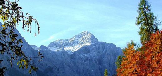
Why the Caucasus? Everything is simple here: firstly, this is Russia, secondly, the region is quite densely populated, so that there are no problems with a car, roads, emergency rooms and communications, and thirdly, in early May it is already real summer here. Primroses and daffodils are blooming, +23 in the afternoon, the sun is shining, but there are almost no mosquitoes. And with all this - short, but interesting turbulent rivers, allowing you to stay at the base camp and make daily trips to the water.
First base camp was planned on the Teberda River, between the villages of New Teberda and Upper Teberda. Zhenya and his family were the first to arrive at the scene around noon on May 2. We found a beautiful clearing, set up a tent on it, lit a fire, and began to wait. On the third hour of waiting, the guys were glad that all the food and cans were in their car. When closer to seven in the evening a group from the plane reached the camp (Anya (that is, me), Shurik, Alice and Natalie), we were already happy with the availability of food, as a ready-made dinner and a pleasant company were waiting for us.
 |
 |
 |
 |
For a complete set, it remains to wait only for grandparents and a dog on a kung. Without them, it would be hard for us, because a catamaran, rafting equipment and Natasha's tent rode along with them. One and a half thousand kilometers from Moscow to Teberda were not easy for them. On the way, they were slowed down by traffic jams, bridges under construction, unplanned detours and other man-made obstacles, so they got to the place after midnight, when everyone was already sleeping in tents. The gravel rustled under the wheels, the headlights cut through the night like a searchlight, the engine stalled, and the door slammed shut a couple of times. "Everything is in place" - I thought. - "You can fall asleep." And fell asleep.
Everything was ready for dinner. The men fixed the catamarans on the roof of the previously hired Gazelle and left the spasiki and helmets inside. Together with a support group, we went up the river. In the camp, little Alice and her grandparents were waiting for us. They promised to cook dinner for the brave rafters and look after things. We went to the river in two crews: Shurik and I on Gosha-2 and Zhenya and Ira on Belraft-2tt, affectionately called "Umochka". Initially, they wanted to inspect the large source of the Teberda - the Gonachkhir River for rafting on it, but during reconnaissance they found several trees blocking the channel, so they started practically from the arrow. We had only two hundred meters along Gonachkhir, but they were very pleasant. Good slope, lots of rocks in the channel, great slalom. Kayakers - and at all beauty. The only negative is that Gonachkhir flows through the territory of the Teberdinsky Reserve, and permission from the authorities is required for rafting. They also tried to stop our group, but we sailed away just like that, swearing an oath that if we start from there again, we will bring permission.
 |
 |
Rafting below the arrow of Gonachkhir with Amanauz is not of interest, since the river breaks into many small channels. However, with a skillful choice of route, you can avoid dragging the kats over the stones. The robberies continue until the village. Teberda, before which the river gathers in one channel. Further, the current becomes faster, small barrels, jet breaks come across. If you wish, you can bypass them all, but then what's the point of going for white water?
By seven o'clock in the evening the catamarans reached the village. Upper Teberda, where it was decided to finish the rafting. Twilight was beginning, and the camp was still at least half an hour away. We phoned for a car and got home just in time for dinner. We were greeted by happy children. They threw pebbles into the river for half a day and explored small aquatic animals. Zhenya looked at the water, appreciated the efforts of the younger generation and complained that the river would soon become shallow.

The river caused a lot of positive emotions, it is easy to walk, there are no criminal places, so the next day we decided to skip the eldest. They rolled the section from the bridge where they finished yesterday to the camp, first on their own, and then with Sonya. They found a rescue for the girl, a helmet, tied the stops. They even gave out the paddle. And headed back to the bridge. Crew change: today on Gosha - me and Natalie, on Umochka - Zhenya, Ira and Sonya. Forty minutes of rafting - and we are back in the camp. The girl has a lot of impressions. We dined in anticipation of the Guy-Rapid, which defines obstacles on this river. After the traditional siesta, games with the dog and other outrages - again at point-blank range. Sonya was left on the shore, but was asked to meet us in Karachaevsk, at Guy's threshold with a car.
After Lower Teberda, robberies began again, which continued right up to the village of Dzhingirik. The river again gathers in one channel just 700 meters before the Guy Threshold, here you have to be careful. At the threshold we moored and got out to look. Our cameramen, Shurik and Sonya, as well as the permanent driver Roma, have been there for a long time. They managed to see enough of the parallel groups, and the herds of sheep and cows, which absolutely independently crossed the river on a suspension bridge in both directions.
 |
 |
The threshold was good: simple and quite spectacular. Foam, barrels, a few unexpected teeth and a clean exit at the very end, making it easy to set up a belay. Zhenya and Ira passed cleanly, along a pre-planned trajectory, and Natalie and I passed twice, but both times with a telemark in the penultimate barrel.

The time was approaching evening, it was time to return to the base and understand our plans for the next day. We ran around Teberda, there was nothing else interesting on it, and the thirst for adventure pushed us further - Aksaut with its canyons was also in the plan. In between, one could visit local waterfalls, look at the ancient Christian temples the times of the Alanian Empire, or get to the Special Astrophysical Observatory, which is in Nizhny Arkhyz. They did it this way and that, but still decided to go to Dombai, one of the oldest ski and mountain climbing base camps in Russia.
Dombay met us with sunshine and warmth. Is it really only one and a half thousand meters up - and snow? Downstairs, I couldn't believe it at all. We parked the cars on some slope, bought tickets for the lifts, picked up the children in our arms and boldly entered the "egg" - the cabin of the first stage. A little acceleration - and the rocky slopes of Mount Musa floated below.
 |
 |
At the first station, woolen knitted items are sold very relevantly, but we are experienced people and warmed up in advance. And now, right on the lift, we pull on hats and mittens. In total, we climbed to a height of 3200m.

A colorful panoramic view of the Greater Caucasus Range opens from above. It can be seen how streams originate from under the snow caps, snow melts on the lower levels of the slopes, and among the dark slopes, unmelted traces of skiers come across every now and then. At the upper station, instructors with a characteristic "spectacle" tan offer to teach a child to turn on skis in just a couple of hours, and snowmobile drivers famously drive along the glacier along with passengers.
 |
 |
Good here! Only there is nothing to eat, you have to go down.
Below us was waiting for a traditional souvenir market and a number of cafes along the main street. We sat in one of them. Okroshka, khychiny, french fries, beef stroganoff and hot water from the tap - that's it, the breath of civilization. Only after leaving the cafe and approaching the cars, we realized that all this time our wheeled friends were parked on the training slope. Over there, near the forest, you can see the supports of the children's ski lift, and opposite - a cafe with the characteristic name "At the Frog Pool". They smiled and moved on.
Initially, we wanted to pick up some geocaching treasure on the way to Aksaut, but due to lack of time, we decided to postpone this event for the return trip.
Along the Aksaut there is a primer of very relative quality. And if you can still drive quite quickly down it, after Hasaut-Greek, the speed had to be reduced to 10 km / h, the road is quite difficult. Only at half past seven in the evening we stopped at the parking lot between the canyons Osypnaya and Krasny. Dusk was rapidly descending into the valley, so that supper was prepared after dark.

On the morning of July 6, Shurik, Natalie, Zhenya and Ira took kats and drove upstream. I wanted to go through the section from Krasny Karachay to the camp. There was plenty of time for this, as well as opportunities, so nothing interfered with the first run along the river.
 |
The children stayed in the camp to collect mint, draw and read books. Alice did not feel well in the morning, her tummy ached, so she clung to her mother and dozed half-heartedly in her arms. Everything was under control. By lunchtime, firstly, the rafters were supposed to return, and secondly, grandparents, who went on an excursion to the SAO, arrived on a kunga. I kept the radio ready and listened to the broadcast. Cellular not on Aksaut, the camp is set up behind the curb, so without a walkie-talkie, the kung could easily pass by without noticing. At about two o'clock, the first call signs began to be heard, and soon the long-awaited car drove up. Just then the catamarans returned. Before sunset, we managed to ride again, I replaced Ira on Belraft, and we went through the lower rafting section, from Krasny to the bottom, with two kats. Surprise. The site seemed to us quite simple, below k. Two Bridges you can even roll children. |
Just below Surprise, a driver in a Gazelle was waiting for us. On such a road, the speed of the catamaran and the speed of the car are almost equal, so for part of the road he rode parallel to us, looking for a place to drop. On the way back, we stopped at the Kishket camp site and booked a bathhouse there for the next evening, we wanted to wash ourselves and wash the children.
As a result, Aksaut was practically studied in one day. It remained to go to the upper reaches and check if there is water in the upper canyons. Generally, highest point, where it is possible to get there is the village of Rudnichny: several houses and a frontier post. There the road ends completely, and the river turns into a stream, oversized even for kayaks. But there was almost no hope that there would be water there. We decided to figure it out along the way. On the morning of the seventh of May, the rafting group got into the car and moved up. Above Red Karachay, the road became even worse, occasionally farms, hay meadows and freely grazing horses came across.

The gazelle slowly climbed the mountains.
We also met camps of other groups. Where are kayakers, and where are catamarans. The trees squeezed the road more and more tightly in their arms, the meadows gradually disappeared, but mossy boulders in human height began to appear and those small delicate flowers that grow only where you rarely meet people.

We were approaching a section of the upper canyons.
At k. Gorbaty everyone got out to reconnoiter, and at the same time stretch their legs. The river did not make us happy: there was not much water, the cat would often cling to the bottom even with proper control, and in the middle of the channel there was a large log. It's a pity, of course, but what can you do, year after year is not necessary.
The gazelle turned around, and we began to descend back, below the robbery site, towards Krasny Karachay.
Not reaching two kilometers to the village, they launched kats. Here was the unexplored Slalom Canyon and the threshold of the same name.

Right-left, left-right, "where are you rowing something?". Twice we ran into a stone, once only the right roll and calmness saved us from the keel. Yes, Aksaut is more serious than Teberda, and much more so. But more beautiful and more interesting. Threshold Cornet added a dent to the frame, and in the Mustang Shurik and I found a beautiful stone. I wouldn't trade white water for anything. Here you can feel the coherence of the crew, feel the shoulder of a teammate. And know for sure that under any circumstances they will help.

When closer to five we moored at a familiar clearing, they already began to worry about us. But what can you do - as the river carries, so we go. Everyone was tired, but happy, and a hot lunch and the expectation of an early bath finally painted the world in pink tones.
At the Kishket camp site, it seems they forgot about us. I had to wait until the steam room was free to sit, take a steam bath, drink tea and, after a quick rinse under a cold shower, return to the camp.
In the morning it became clear that Alice's condition had not improved, and Ksenia also fell ill with the same symptoms. We need to decide whether to break camp and take the children to the hospital, or leave it alone for a couple more days and observe the dynamics. Still, the girl did not become worse either.
In any case, the fusion is over. Shurik and Zhenya began to dismantle the catamarans, and grandfather Borey and I went towards civilization, to try to call the doctors we knew, to consult.
When three independent experts came up with the same prescription: stay hydrated, don't force feed, and give rehydron, our plans began to take shape. Buy medicines, give the children water to drink, don't go anywhere until at least tomorrow. And so they did.
The next morning, May 9th, the girls finally got better, and the whole team, with the exception of Alice and me, who remained to guard the camp, went on an excursion to the waterfall to bury the treasure. When choosing to travel somewhere, we try to take with us all sorts of small things for the caches of the Geocaching game. Usually we find other people's hiding places, but this time we decided to bury our own.
After a late breakfast, we slowly loaded into the car and drove to the landmark of the beginning of the trail - footbridge through Aksaut.
Having crossed the bridge, we turned right and went up the path, surrounded by ferns in human (well, Ksyushin) growth.
The path to the waterfall goes up the stream, constantly moving from one bank to another. This was done more so that people would not get bored on the way than out of necessity. Nevertheless, the team courageously moved over the pebbles from shore to shore. Vista crossed 20 times more than they did, and in general, judging by the number of runs, she found a couple more unknown waterfalls in the area.
 |
 |
The trail is not difficult, at least in dry weather, and instead of the promised hour, the guys reached it in 40 minutes. Going around the next turn, they were surprised to find a waterfall. Tall, powerful enough, illuminated by the sun, in general, take pictures - I don’t want to.

Some wanted to - and took up photographing against the backdrop of a waterfall. Someone climbed up the scree on the side of the waterfall to find a place for the treasure. The most unfinished (Zhenya and Sasha) climbed the highest, found a place and laid the treasure of geocaching.
When we went downstairs, we had a bite to eat, discussing the folk fun "throwing Vista into a waterfall" along the way - they threw Vista there twice, supposedly for cooling. It is surprising that Vista did not fall down from the owner who threw her, but joyfully galloped nearby.
Sasha and Zhenya, apparently, did not completely get sick, so they decided to build a dam to raise the water level in the "bath" under the waterfall. After fifteen minutes of carrying the stones, the dam was still not ready, but the sequence of stones increased greatly, and the guys finally got sick of it!
After that, everyone gathered and went back along the path. Going down is easier, so we went down quickly and without incident. In a word, the waterfall (and the path to it) are worth a visit!
 |
 |
 |
And in the evening, in the setting sun, the Maslovs in full force, Shurik, Natalie and I rushed to find out where the stone staircase went, which starts right from the road a couple of hundred meters from the camp. If the child were still not lethargic and she would be captured, the climb is easy and accessible to almost anyone. It's all about the number of stops along the way.
At the top of the mountain, a Christian cross was waiting for us, shamanic ropes swaying in the wind, flowers and candles. In general, such a hodgepodge of different religions is typical for these places. People here seem to be both Christians and Muslims, well, they believe in spirits at the same time. Under the cross is an icon, it is clear that the place is known, prayed for, that it is often visited and kept in order. You can observe the panorama of the valley, dangling your feet into the abyss. Half a step and that's it. There is a sharp edge here. Moreover, the icon and the cross are dedicated to those who left early.
We descend already at dusk, from the foot of the stairs to the camp about ten minutes on foot.

In the morning we slowly got together, scattered our backpacks around the cars, wished each other a happy journey and drove off in different directions. Kung went to Moscow, taking his grandparents with him, as well as our tents, sleeping bags, a catamaran and wetsuits, Qashqai and the Maslov family moved to Voronezh, and the rest went to Minvody on a Gazelle with a stop at the Shoaninsky temple.
Imagine that a stone temple has been standing on a mountain for a thousand years. And, judging by the state of the masonry, the same amount will stand. The walls and roof of the building were not renovated, they are the same as they were created by unknown builders in the 10th century, either the Alans or the Khazars. Services are still being held in the temple. It's about as if wild lions were driven into the Colosseum and gladiatorial fights were arranged. And all this antiquity does not frighten or suppress you, but calms you down. "Everything will pass," she seems to say.
At the temple, we hastily examined the interior, Natalie and Shurik climbed down the steep slope to the top of the mountain for the geocaching treasure, noted in the notebook, and quickly moved to the car. There was just enough time to get to the plane on time.
The car didn’t let us down, the roads didn’t let us down either, by the end of the registration we still had time. Goodbye, Caucasus, thank you for giving us a piece of summer.
Anna Satovskaya
Aksaut River
The length of the rafting is about 75 km; duration - 4-5 days; III category of complexity; seasonality - April-September; means of alloy - kayaks, inflatable boats, rafts, catamarans. The Aksaut River originates from the large Aksautsky glacier, located on the Main Caucasian Range. Rafting usually starts from the village of Aksaut, where you can drive up, from the village of Zelenchukskaya by passing car (by bus you can only get to the village of Khasaut-Grecheskoe). In the area of the village, the river flows in a wide valley overgrown with mixed forests. Here it is divided by pebble islands into several small but fast foamed arms. After 2 km, all channels merge into one channel 10-15 m wide, and the first threshold of Aksaut begins, 300-400 m long. At the end of its steep 1.5-meter discharge.
Behind the hanging bridge after the threshold, the river again spreads widely through the valley for 3-4 km, then the channel narrows and in it - the second threshold. 100 m below the threshold - a canyon about 2 km long. A relatively calm 700-meter section separates the canyon from a 1-km-long steeply falling section with a cascade of complex rapids that end behind the bridge over the Aksaut. This entire 8-kilometer stretch below the mouth of the Khalega River, with a slope of about 18 m / km, must be carefully explored. Below the bridge, a calm section of the river begins, which stretches almost to a dairy farm 3-4 km above the village of Krasny Karachay. Behind the farm, Aksaut flows in one channel, its slope increases, a series of complex rapids requiring detailed exploration is formed, alternating with shivers and less often with short sections of rapids.
Approximately 7 km below Krasny Karachay, the road passes to the left bank, and perhaps the most dangerous rapids of the river begin behind the bridge. 200 m below the bridge - the first one, which stretches for about 2 km and is separated from the second "explosive" threshold by a stretch. In the area of the "explosive" threshold, huge blocks impound the river, forming a stormy drain. Behind the threshold, Aksaut, already narrow, is even more compressed by low steep walls of a simple (about 300 m long) canyon, where there are single stones, steps with short plumes. Below the canyon, the rapids are more isolated and shorter, separated by long stretches of rapids where it is easy to land on the shore. The gorge here is deaf and wooded. In front of the village of Khasaut-Grecheskoye, there is a second “explosive” threshold on the way of water workers: the river here is almost completely blocked by stones.
Behind the forestry, Aksaut spreads widely in channels, winding among the banks overgrown with willows, therefore, when the water is low, it is recommended to end the hike in Khasaut-Greek. In high water, the rafting can be continued for another 20 km - to the village of Kardonikskaya, from where you can take a regular bus to Cherkessk.
In the Aksaut valley there is a small village of Krasny Karachay livestock breeders and a half-abandoned village. Aksaut founded by geologists ( locals more know it under the name Rudnichny), dairy farms operate in the summer. There are many tourists in the gorge. Along the rivers Kichi-Teberda and Ullu-Marka, the right tributaries of the Aksaut, you can go to the passes to Teberda and Dombay. There are trails to the hanging valleys of the left slope, where the shepherds stand. From there there are easy, albeit high, passes to the Marukh valley.
Aksaut originates from the large GKH glaciers in the area where average height exceeds 3500 m. Glaciers, including one of the longest in the West. Caucasus l. Jalau Chat are quite accessible and can be visited by novice tourists with an experienced leader. Climbing the snow-ice passes and peaks of the GKH is attractive for sports groups.
The river breaks out of the mountains near the station. Kardonikskaya, through which the highway from Cherkessk to Zelenchukskaya passes. The turn to the road up the Aksaut is located near the Kardonikskaya bus station. A bus runs along this road several times a day from the station. Zelenchukskaya in the village. Hasaut-Greek (less than 20 km). Then you need to get by passing cars about 25 km to the village of shepherds Krasny Karachay, which serves as a starting point for routes along Aksaut. Opposite with. Khasaut-Grechesky you can see the portal of the tunnel, the construction of which began in the Soviet years. It was intended to transfer water from Zelenchuk to the Kuban. The spurs of the Front Range approach the village.
Aksaut flows out of a wooded gorge onto spacious pebbles. The road to the village Red Karachay is laid along the bottom of a deep gorge and pressed against the river by steep slopes covered with dense deciduous forest. Occasionally, the valley widens a little, giving way to clearings where foresters have set benches for rest. A few kilometers from the Khasaut-Grechesky, at the "Wet Glade", through the bridge on the left side the road branches off to the Yesen pastures. Gradually, the forest thins out, becoming mixed (there are also artificial pine plantations), and above you can see meadows, monotonous scree strips, rock ridges. At 9 km in the tract Kyshkyt rest camp.
The valleys that cross the Front Range are evidence that its uplift began no earlier than the uplift of the Main Range. The rate at which the flow originated on the main watershed bites into the underlying rocks increases with the general rise of the system (as the slope increases) and turns out to be faster than the average erosion of the massifs of the Front Range. As a result, deep (and in the morphologically young near-bottom parts - steep-walled) gorges and canyons in hard rocks are developed. The longitudinal profile of the valley also changes with time: steep, intensely cutting drops slowly move upwards. The strength of the river was always enough to saw through the gap faster than the raising of the ridge, so that dams did not form.
Even in dry weather, Aksaut has muddy water. During the rains, the river erodes the banks, islands, carries trees, layers of turf. The sound of moving stones is heard. The material for this conveyor, which distributes sediments, is supplied by alluvial fans of numerous tributaries. Several times the road with short ascents and descents briefly moves away from the river. The last kilometers in front of Krasny Karachay, it goes through an open valley, in the middle of which farms, sheds, sheds are scattered. The village is located at an altitude of 1500 m at the confluence of the Aksaut river. Ullu Mark. There is a cheese factory, farms are scattered in the vicinity, which are driven around daily by a milk truck. There is no post office, the nearest one is in the village. Hasaut-Greek.
M4. The village of Krasny Karachay - pos. Aksout - l. Aksaut (29 km, road, trail).
From the village Red Karachay up the left bank of Aksaut there is a road to the former settlement of geologists. Behind the village is a camp for schoolchildren. The wide floodplain of the river is occupied by meadows, groves, the sides of the gorge are covered with forests. Along the road stretches a chain of dairy farms. It is cool in the valley, it is blown by winds from glaciers.
Eight kilometers from the village. Red Karachay with a spacious, raspberry-colored glade from blooming thistles with groups of pines and birches, for the first time, the jagged rocky ridge of the Kara-Kaya mountain (3893 m) is visible. From the farm behind the clearing begins the ascent (through the burnt-out) to the lane. Kyzyl-Aush to the Marukh valley. We soon pass a stone gate between low walls with loopholes. On the cast plate is the inscription: Memorial Complex Defense Trail
This is the first of the monuments erected in the mid-80s. on the way through the Marukh Pass, where heavy fighting took place in 1942
The last farm is 0.5 km from the monument. On the slope above it, in a strip of bushes, a trace of a powerful avalanche is visible. At a time when the road to Rudnichny operated year-round, avalanches threatening it were shot down from cannons.
We pass through the river. Khadyuk, flowing from a wooded gorge, along which there is a path to the pass of the same name on Marukh. From the clearing near the bridge, the Aksauta rocky massif (3910 m) with glaciers, closing the Aksaut valley, was opened, and to the left of it - the dark pyramid Mal. Aksaut.
At 12 km from the village, the road passes over the bridge to the right bank of the Aksaut and rises to an uneven clearing bordered by birches, aspens, spreading beeches. There are rare pine trees near the river. From here you can see the peaks of Aksaut and Kara-Kaya. Then we go to the mixed forest, where there are a lot of strawberries and mushrooms.
After 8-9 km from the bridge, the road leads to the village, located among the pines at an altitude of about 1900 m and 0.5 km from the confluence of the Aksaut river. Kichi-Teberda. In the massif of the city of Kichi-Teberda, towering above the entrance to this valley, tungsten ore has been mined for about 30 years. Now several houses of Rudnichny are occupied by border guards and rescuers.
Along the river Kichi-Teberda lies the path to the lane. Khuty to Teberda and to the passes of the 73rd and Kichi-Teberda to Dombay. A little higher than the village, a trail descends to Aksaut from the lane. S. Kara-Kaya from the Marukh gorge.
Beyond the village, the road forks. One turns into the valley of Kichi-Teberdy, from where it climbs to the adits on the slope of the mountain of the same name. Another, less fortified initially and now rapidly collapsing, crosses the river. Kichi-Teberda, above which, in the forest, a waterfall rumbles, and continues on a rocky floodplain in the direction of the right slope, visible in front of a wooded cape.
At the riverbed, stone ridges piled up by bulldozers are noticeable in order to prevent the branches of the river from reaching the buildings and the road. Pine trees have strengthened on the protected part of the floodplain. However, the left-bank forest is dying, which has become more often flooded with floods carrying stones. On a sultry July day, the air above the hot pebbles is infused with carnations. But the snows of the Main Range are close. Ahead, in the green alignment, a heap of icy rocks of Aksaut has grown, to the left rises the dark tip of Mal. Aksauta and the pockmarked snow-covered wall of the city of Dzhalau-Chat (3884 m). The Aksautsky glacier is already visible.
There is a mighty fir forest on the cape. In the shade of old trees, hung with lichens, it is always damp, puddles darken on the stones. A road was made in the forest to the adit, the dump of which was visible 100 m above the floodplain. Trunks and roots of firs near the road are damaged. Meanwhile, all sorts of wounds, even due to breaking off branches, cause rot damage in Caucasian fir, as a non-resin-producing breed. A forest with a large proportion of injured trees is doomed.
Behind the cape Aksaut receives the turbulent flow of Jalau-Chat. Just below the confluence, a thick log is thrown across the river. On the hillock of the left bank overgrown with pines, there are traces of old lodgings. A few hundred meters up the river. Jalau-Chat, where it breaks out of the canyon, hangs a bridge with a railing. In front of this bridge, the path to the lane goes up, into the fir forest. Alibek.
About 4 km (2-3 hours of walking) remains to the Aksaut glacier. There are trails on both banks of the Aksaut, at the end of summer the right bank is more reliable, because there may not be a snow bridge over the stream that flows into the Aksaut on the left just before the Aksaut glacier.
Behind the crossing through Dzhalau-Chat the forest becomes smaller - the proximity to the glacier affects. A little higher, Aksaut is squeezed by a gorge, and the coast becomes impassable due to thickets of birch. It is better to overcome them further from the river. At the exit from the bush, the foresters set up a pillar - this is the southern border of the forest in the Aksauta gorge. It is still about 2 km to the glacier on the rocks along the river.
In the south, its icefall is clearly visible, hiding the crest of the lane behind it. Aksout. The tongue of the glacier is strewn with stones, but the very end (about 2200 m) is clear - a smooth ice slope. From time to time, stones slide off the slope - this is how the final moraine is deposited. On the flat right moraine overgrown with willow, you can camp.
In front of the tongue of the Aksaut glacier, a stream flows into Aksaut from the west from a narrow gorge between the massifs of Kara-Kaya (on the right for the observer) and Bratsy. Zap. Aksaut, to which about 2 km. Previously, this glacier connected with the Aksautsky glacier, as evidenced by the high ridge of the lateral moraine left on the left bank of the stream. K Zap. We make our way along the right bank of the Aksaut glacier. After 1.5 hours of a noticeable ascent, we reach a steep tongue (2400 m). Having climbed the glacier, we walk along it for about an hour before turning to the south, behind which a wide snow lane opens. Zap. Aksaut (it leads to the Karach River - the left tributary of the Yu. Marukh).
Around the lifeless rocks of the peaks of Kara-Kaya, Bratsy, Marukh-Bashi. The noise of the river does not reach here, the silence is broken only by the roar of ice landslides from Marukh-Kaya. To see the mountains awaken from their icy stupor, it is worth spending the night here. There are sites on the left moraine under the river. Yu. Karakaysky, falling from the saddle between Kara-Kaya and Marukh-Bashi.
M5. River valley Aksout - l. Jalau Chat(trail, 1 day).
The Jalau-Chat River originates from one of the largest glaciers in the West. Caucasus, to which you can climb, using the path laid around the canyon leading to the lane. Alibek.
You can get on the trail by turning into the forest from the last knee of the road from the cape to the adit (M4), at the gas tank. The overgrown path rises above the canyon in a fir forest, then in a mixed forest. Only having gained several hundred meters of height and having entered the zone of crooked forests, it approaches the edge of the gorge for a short time. You can see the beginning of the canyon, the walls of which are smoothed into "ram's foreheads", and the snowy fields of the glacier. The trail continues climbing through the beech forest, birch bushes, mountain ash, rhododendron. It is very steep in places - a dirty chute straight up. This is a feature of hiking trails, pastoral trails are lighter, with zigzags.
Finally, we get to the meadow shoulder above the cliff, where you can rest. A path branches off to the left, traversing the slope of Kichi-Teberda near the bush border and leading to the mine adits. It would be possible from the village. Aksaut climb to the adits along the road and go to the canyon along this path (this is how they do it more often now). Now the tongue of the glacier is clearly visible (it seems that we are already almost on the same level with it) and the upper cirque, torn by cracks, above which the snow-capped peak of Jalau-Chat has grown. It remains a little to the place where you can turn to the glacier.
The trail climbs a gentle meadow with a stream and a paddock (graze sheep) in a hollow between the long grassy slope of Kichi-Teberda and the short rocky scree of Sulakhat (3409 m), which is now visible in the east. To the north of this peak, in front of the hollow, one can see the snowy saddle of the lane. Sulakhat, leading to the valley of the river. Alibek, in Dombay. Still further north is another pass in Dombai - Alibeksky, now hidden by the slope of the city of Kichi-Teberda. Its saddle with a characteristic rock-"horn" can be seen by climbing the mentioned spur of Sulakhat. The Alibek pass is very popular, and in the hollow where we climbed (2400 m), people often stop to rest or spend the night. This place is called "Green Hotel".
to l. Jalau Chat (now we are at his level) remains 1.5-2 km. To get there, you need to go around the spur of the city of Sulakhat. A simple, with a slight decrease, the path along the old, overgrown with grass and small bushes "ram's foreheads" leads to a flat sandy field in front of the tongue of the glacier (2310 m). If you go higher, with the intersection of unstable talus (several hundred meters), you immediately get to the glacier. In the lower reaches, its surface is flat, and it is easy to advance to the middle of the glacial cirque.
With each step, the panorama of the surrounding peaks unfolds wider. Above the belt of "sheep's foreheads" and the hanging glaciers of the left slope (for the observer on the right), the sheer walls of the Aksaut massif rise. In the south, behind the icefall, the snow-rocky hump of the Dzhalau-Chat mountain grows. Marked by rare gendarmes - "teeth" depression in the snowy ridge next to it - lane. Fog.
The broken crest of the buttress, holding the icefall at the starboard side, leads to the top of Sunakhet. To the north of this peak, above the strip of “ram's foreheads”, there is a gentle glacier of the same name (there are bivouacs in front of it). On the glacier it is easy to climb the lane. Dzhalau-Chat (in Dombay). Opposite, in the northern ridge of Aksaut, the saddle of the lane is visible. Lower Aksaut (3000 m, 1A), leading to the l. Aksaut, and a snow-scree couloir under it. On one of the median moraines or on the aforementioned sites on top of the "foreheads" (in front of the Sunakhet lava), you can get a lodging for the night. Return along the path of ascent.
Aksaut is one of the most abundant rivers flowing through the territory of Karachay-Cherkessia. It originates from the glacier of the same name and merges with the Marukh River 75 kilometers from the source, forming the Maly Zelenchuk River.
Aksaut flows through a valley stretching from south to north between high mountain ranges Mysty-Bashi and Aksaut. This ridge in some areas has different names: Gitche-Teberdinsky, Ak, Baduksky, Khadzhibeysky, Kynyr-Chat, Gidamsky and others. But in general, this complex knot of mountain ranges, dissected by valleys and gorges, can be called Aksautsko-Teberda. In its system there are passes: Alibek, Gitche-Teberda, Seventy-three, Khuty, Baduk, Muhu, etc.
On the ridge of Mysty-Bashi a large number of lakes, but many of them are little known.
The upper reaches of the valley close the chain of high rocky peaks: Kara-Kaya (3896 m), Aksaut (3910 m), Maly

Dzhalovchat (3600 m), Dzhalovchat (3870 m), etc. The huge massif of Aksaut rises above all the surrounding peaks and ridges.
About 50 tributaries flow into the Aksaut River. The most abundant of them are: Djalovchat, Gitche-Teberda, Khalega, Khadyuka, Bolshaya Marka.
The Aksaut valley is rich in forests that have taken over the slopes of the ridges from their foot to subalpine meadows. Above the mouth of the Khadyuka, the bottom of the valley is also covered with forest. In the upper reaches of the Aksaut, in amazing proximity to the glaciers, a site of an old fir forest has been preserved. This small island of coniferous forest makes an unusual impression with its wildness and primeval untouchedness. It seems that you find yourself not in a forest, but in an underwater kingdom: long strands of lichen barely noticeably move like algae. Even the wind does not penetrate here. Complete silence, only in the canyon Jalovchat makes a dull noise. Local forests give a special charm to Aksaut landscapes, strikingly contrasting with snow spots scattered on the slopes of rocky peaks and glaciers.
There are many predatory animals and wild animals in the forests: bear, deer, wild boar, wolf, forest cat, lynx, marten and others.
The climate of the Aksaut valley is typical for mountain valleys. It depends on the height above sea level, position among the mountain ranges, the degree of dissection of the relief, the proximity of the Main Caucasian Range and the penetration of moist masses of sea air from the southwest. In general, the climate of the upper reaches of the valley is not much different from the climate of Dombai, and in the area of the village of Krasny Karachay it is the same as in Teberda. But in winter, more snow falls here, since this area is located at an altitude of 1560 meters above sea level, that is, 260 meters higher than Teberda,
The natural conditions of the Aksaut valley are so rich and varied that it is of great interest not only for tourists, but also for climbers.
The upper reaches of the valley are a kind of climbing "neighborhood". Here you can climb routes from 1 to V category of difficulty.
A dirt road leads along the Aksaut valley, which starts from the village of Kardonikskaya. Along the way, after 18 kilometers, in a picturesque area, the village of Khasaut-Greek is located. Behind it, after 25 kilometers, at the mouth of the Bolshaya Marka, is the village of Krasny Karachay, which is the starting point for hiking from the Aksaut valley. Converge here tourist routes leading from Arkhyz to Teberda and from Teberda to Arkhyz. A path passes through the village to the upper reaches of the Aksaut and further through the passes to the valleys of Marukh, Alibek, to Dombay, to the lakes of Baduk, Kynyr-Chat and Khaleg, to the waterfalls of Hadyuk, Ullu-Chuchkhur and other places of interest.
The abundance of tourist routes, the richness and beauty of nature create exceptionally favorable conditions for mountain travel in the Aksaut valley and put it among the best tourist areas of the Stavropol Territory.
ROUTES FROM THE AKSOUT VALLEY
Lake Kynyr-Chat
The path to the rarely visited lake Kynyr-Chat starts from the eastern outskirts of the village of Krasny Karachay. Behind the aul, the path immediately deepens into the forest and leads higher and higher, skirting the rocky massif of the Kynyr-Chat mountain from the north.
Having crossed one of its spurs, the path leads to the Gidam tract to the Igda stream, which originates from the lake Kynyr-Chat, which means “crooked hollow”. Further, the path goes upstream of the stream. As you rise, the view of the Aksaut valley opens up wider and wider,
Soon a small nameless lake is encountered, into which the Igda stream flows and then flows out.
Lake Kynyr-Chat, like a precious stone, is hidden in a frame high mountains. Calm, reliably protected from the winds by a semi-circle of rocky spurs of Kynyr-Chat, which reared its peak at 3,540 meters above sea level, it appears unexpectedly.
Kynyr-Chat lies at an altitude of more than 2,900 meters above sea level. The surrounding landscape is harsh, but it will captivate the eyes for a long time with its grandeur and beauty. Lake Kynyr-Chat deserves to become popular among tourists, despite some remoteness from the main tourist areas - Teberda and Arkhyz.
One day is enough for an excursion to the lake from the village of Krasny Karachay.
Ullu-Chuchkhur
About 12 kilometers from the village of Krasny Karachay, along the Aksaut valley, the road passes to the right bank and leads through the forest. Soon, behind the bridge, a large clearing opens up. 3a it, after a few kilometers, the second, called Byshlak-Tapkha, which means “cheese shelf”. From here, it's about an hour's walk to the waterfall.
The third glade at the mouth of the Gitche-Teberda lies at an altitude of 1,680 meters above sea level. Previously, there was a small village Rudnichny. Already from here you can hear the sound of the waterfall, but the path from the village of Krasny Karachay to the mouth of Gitche-Teberda is not close. It's time to take care of the lodging for the night, you can admire the waterfall later.

There are many waterfalls in the mountains, but Ullu-Chuchkhur is special, unlike the others. It has its own, unique beauty, its own “symphony” of noise, its own charm. The water is cold as ice, clean, surprisingly transparent, like in the Teberda River. Therefore, the river is called Gitche-Teberda, that is, little Teberda.
From sheer multi-meter rocks, from ledge to ledge, with noise and roar, a river full of water in summer falls, forming a waterfall of rare beauty. At the place of its confluence, the water boils, roars white with foam, and, breaking out of the bubbling cauldron, either rushes furiously onto the shores, or with all the power of the wave it jumps on the pitfalls, raising spray.
Rocks, pine trees and a waterfall bluish-white from the foam blend surprisingly harmoniously into the surrounding landscape.
It is interesting to walk at least a little along the path leading to the Gitche-Teberdy valley, from where a wonderful view of the rocky pyramid - the majestic peak of Kara-Kai opens.
From Aksaut to Dombay
We already know the way to the Rudnichnaya glade at the mouth of Gitche-Teberda along the route “Ullu-Chuchkhur” (88). From the glade a good zigzag path leads to the valley of the river Gitche-Teberda. On the way from one of the turns you can see a waterfall. Behind the forest zone, in the upper reaches of the valley, a low ridge rises with two passes: Gitche-Teberdy and to the left of Seventy-three, through which you can go to the Alibek valley.
After an hour and a half of walking Gitche-Teberda gradually turns to the left. In the upper reaches of the valley, on the left, the rocky peak Bolshaya Marka (3,768 m) opens, dominating the surrounding ridges. A crest humiliated by the “gendarmes” departs from it to the east and connects with the spur of Semyonov-Bashi. Now you need to focus on a rocky peak rounded from above in such a way as to get to its right slope, steeply falling to the Khuty pass. Gitche-Teberda remains on the left, and the path lies first along the terraces, then along the stone rubble.
The Khuty pass is a depression in a rocky ridge in the form of a wide crevice. From it you can admire the beautiful valleys of the Khuty and Gonachkhir rivers for a long time. On the left you can see a small glacier and the impregnable wall of Semyonov-Bashi.
The descent from the pass is quite steep, but the trail is visible. Sticking to the rocks (on the left), you need to go down a long hollow (in the first half of summer there is still snow in it), then along an old moraine overgrown with twisted birch trees. The outcrops of rocks located along the path of descent must be bypassed on the right. The path leading down the valley is overgrown in places. The Khuty valley is one of the wildest corners of the Teberdinsky Reserve. Tourists visit it occasionally, so you can see wild animals here; deer, chamois, tour, and even a bear.
A gentle, tireless path through the valley soon gives way to a steep descent. The trail leads to the Amanauz River at the mouth of the Khuty. From here to Dombay is no more than an hour's walk.
From Aksaut to Dombay the transition takes 8-10 hours.
From Aksaut to Alibek
Two ways can be suggested: the first one is through Alibek, the second one is through the Seventy-Three Pass. The last, little known pass from the second half of summer becomes more difficult when a small but rather steep glacier is exposed from under the snow. The Alibek pass, on the contrary, becomes easier in the second half of summer. From the village of Krasny Karachay to the glade of Rudnichnaya, at the mouth of the Gitche-Teberda, the path is already familiar from previous routes.
Having crossed the Gitche-Teberda along the masonry or, if it has not been preserved, wade, you need to go along the edge of the forest to a small clearing with traces of fires. Here, look for an overgrown path that leads beyond the forest zone and climbs a steep slope with rich meadow vegetation.
The path then continues to the right old trail to a small clearing on which huge blocks of rocks lie. This is the so-called "Green Hotel". From here you have to go up the river, then along the moraines, past the lake and the waterfall. In the upper part, behind a rather steep ascent, a red-brown “gendarme” appears. To the left of it is the Alibek pass. There is snow on the saddle all summer.
The descent from the pass is quite steep at first. In the first half of summer it is still covered with snow. Having descended a little, it is better to go obliquely to the left, choosing more sloping places. The trail starts below. In the valley, it connects with the path leading to the Alibek glacier, the most frequently visited by tourists.
The further path does not require a description. Everything is clear here. Behind the clearing is the climbing camp "Alibek", a road leads from it.
From the upper reaches of the Aksaut to the Alibek valley, the transition takes 8-10 hours.
Halega Pass
From the village of Krasny Karachay, the path leads up the valley. About 12 kilometers away, near the bridge over the Aksaut, a path branches off from the road and goes along the left bank. At the Khalega River, you need to go to a well-marked path that turns to the right, to the pass of the same name, located on the Mysty-Bashi ridge. Above, it deviates to a small scree and soon leads to a saddle.
Behind the stream, a short ascent ends with a wide alpine valley. At the barn, the path crosses the scree and leads to the first terrace. From here you can see the rocky pyramid of Kara-Kai. Behind the first terrace is the second. Across the stream, the cold, gloomy Khalega Lake soon opens, near which, at a low altitude, the obelisk of Glory stands alone in memory of those who gave their lives in the battles for the defense of the Marukh Pass. There are dilapidated dugouts near the lake, rusty shells, mines, shells are lying around.
 From the lake to the pass 30-40 minutes walk.
Kara-Kaya seems even more formidable from here. Marukh-Bashi looks majestic and gloomy. But of particular interest is the Marukh Pass covered with glory, visible from here in full view. The western slopes of the Mysty-Bashi ridge are clearly visible, where on August 28, 1942, the 810th Infantry Regiment met with the advance detachment of the Edelweiss Alpine Division and completely defeated it by the end of the day. Prisoners were taken, many trophies were captured - equipment and food.
The 810th regiment fought its way to the aid of its distant right neighbor, the 815th rifle regiment, which had been fighting heavy battles in the highlands of the Military Sukhum road for many days. Wishing to alleviate the position of the defenders of the Klukhor Pass, the corps command ordered the 810th Regiment to cross the Khalega Pass, descend into the Aksauta Valley and further, in the Gonachkhir area, reach the Military Sukhumi Highway, where to strike at the Klukhor grouping of the enemy.
From that day on, almost without ceasing for one hour, on the slopes of the Mysty-Bashi ridge, a many-day fierce battle thundered ... mountain passes in this area are covered with unfading glory of heroes who fought to the death and did not let the enemy through in Transcaucasia. Their feat is marked by monuments on the Marukh Pass, in the village of Zelenchukskaya, near Karachaevsk and other places.
From the Khalega pass, the trail leads to the Marukhi valley, from where you can go to the Marukh pass or go down the valley and continue on through the Ozerny pass to Arkhyz,
To the Baduk lakes
From the village of Krasny Karachay to the clearing at the mouth of the Malaya Marka, the path coincides with the route “From Arkhyz to Teberda” (70). Then it goes up the Great Marka valley. Above the forest zone, in a small pine grove, which is clearly visible from afar, you can stop for the night. There will be no more firewood behind the grove. First day hiking will only take 5-6 hours.
From the place of spending the night, you should continue the path until the Aryu-Chat tributary flows into the Great Mark, then climb the first moraine terrace and cross the swampy area. It is better to go along the right bank of the river, past a small lake with rusty water and rocky gates, from which a powerful stream bursts out with noise. This area is easy to bypass on the right. On the way to the right, the blue Markinskoye Lake opens up.
The pass jumper is bounded on the right by the rocky ridge of Bolshaya Marka, on the left - by the massif of the Baduk Fingers peak. The way to the pass jumper goes along a gentle scree slope (there is snow here until August). In the middle of the lintel, on a high moraine ridge, there is a stone pyramid of the tour.
The descent is somewhat more difficult. From the first terrace, which breaks off with rocks, one should go down a hollow, reminiscent of an old channel. You can see the lake below. They descend from the second terrace in the same way. Below the hollow becomes deeper. The trail is already visible here. It is clearly visible to the very Baduk lakes.
The descent from the pass bridge to the trail takes about 40 minutes. And from here it’s about another two hours’ walk to the lakes, where there are convenient places for an overnight stay.
From Baduk lakes to Teberda 16 kilometers. This route is only available to hikers with experience in mountain travel and appropriate equipment.