Mount Tuzluk, as a permanent sentry, has always met and attracted pilgrims going to the Holy Places of the Northern Elbrus. And now it is impossible not to pay attention to this miracle of nature. And maybe not only nature.
For a long time I tried to understand the meaning of the name of this mountain. It was very senseless to combine the name of the mountain with a saline solution - brine. But once a completely different bundle arose: ace - az - ace and bow as a weapon. (Ace is the first, the main card in the deck, an important person; Az is the first letter in the alphabet, the pronoun - I know God, the self-name of the peoples of Azov, Ases).
And indeed, the mountain, when approaching it from the north, first looks like a bow with a loose bowstring, and then, when approaching it, takes the form of a sharply drawn bow. So, maybe Tuzluk - Azluk - Asluk, - the bow of Azov, Asov, or my bow.
The first time I saw her was twenty years ago. She seemed very curious to me then. But as always in a sports trip there is no time for extraneous research. It is necessary to keep within the schedule of the hike and before dark come to a place convenient for a bivouac.
And only in 2005, within the framework of the "ELBRUS - RUSKOLAN" expedition, we planned several hours to survey the region of this mountain.
We left the base camp on Dzhilysu in the second half of the day and, having overcome the Kayaashik pass, in the evening were at Tuzluk. Having asked for shelter from the spirits of the owners of the mountain, we settled down to spend the night next to the spring at the eastern foot of it.
In the morning of the next day, unexpectedly, a GAZ-66 drove up to us from the direction of Kislovodsk with a group of climbers heading for Elbrus. At 16 o'clock he was supposed to return and promised to take our group of 15 people to the Narzan Valley.
So it was given to us, I think, by the same perfume, for a whole day, and not a few hours, as planned, and we did not lose it in vain. Everyone dispersed in small groups, where curiosity drew anyone.
In the evening, by the fire in the Narzan Valley, everyone told about what they had seen. And I managed to see a lot of interesting and even mysterious.
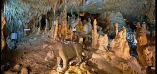
Pavel Otkidychev discovered fragments of rocks with prints of tree trunks in the canyon of the Malka River, some small objects that have not yet been explained, cave drawings in the shape of a cross along with a triangle or pyramid and coal seams. And these are not all the riddles that he and other members of the expedition saw.

Cross and triangle. Similar pictureavailable on the northern slope of Mount Sirch.

Ladder and coal seams.
A stone staircase rises from the Malki canyon to the plateau, to the mountain, in the place closest to it. Judging by the photographs, it seemed to me a natural formation, but two to five thousand years ago, this staircase could have been pulled down, equipped with a handrail or rope, and then it would not have been difficult to climb up this staircase.
In the photo, next to the stairs, coal seams are visible, which could have been used in the ancient metal-melting furnaces previously discovered by the expedition of A.A. Alekseev and A.G. Evtushenko, very close, on the Tashlysyrt ridge.
And something magical happened to Zhanna Demina, the geologist of the expedition. She left with her daughter Olga, a great connoisseur of flora, now a student at the Timiryazev Academy. They climbed to the top of the mountain, examined the summit rock (I will describe it later), went down, walked around the mountain and, softened by the sun, settled down to rest on the beautiful alpine meadow... And suddenly Jeanne saw a procession of people dressed in dark long tunics with their heads covered with hoods. People slowly passed by and went into the mountain. The last of them turned to Jeanne and silently beckoned for him. She became scared and it took a very great effort of will not to succumb to this call. She neither then nor now does not know whether it was all in reality or it was some kind of obsession. Of one thing she is sure that she was not asleep at that moment.
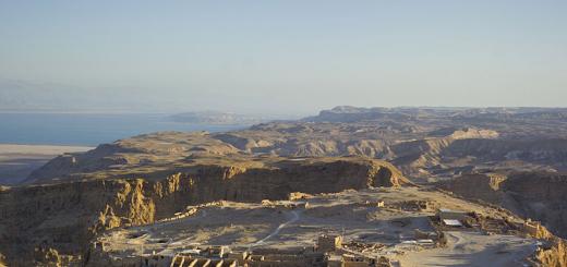
Mount Tuzluk itself (2585m) is located a couple of kilometers north of the Kayaashik pass and 500 m from the menhir, on the watershed of the Malka and Ingushli rivers. As a lonely peak, it advanced to the North from the root peak of the Tashlysyrt ridge of Mount Sirkh. Its silhouette of a regular shape in the form of a giant cone-pyramid is striking.
According to the results of a preliminary geological survey by Vyacheslav Tokarev, the mountain itself is a natural mountain range from layered hard quartzite tuffaceous sandstones, in the steep upper part, and from weakly cemented to loose - sandy-argillaceous tuff wavy strata in the gentle lower slope of the base.
The feeling of hand-made refinement of the slopes and the top of the mountain does not leave - some refinement into a geometrically correct shape. Some researchers of the Cheops pyramid argue that at its base there is a similar rocky outlier, lined with stone or concrete blocks, giving the structure the correct shape. Only Pyramids of Egypt a couple of thousand years younger than Mount Tuzluk. This mountain, apparently, was the center of a large cult sanctuary.

Megalith is a monument of phallic culture and Tuzluk mountain.
The mountain is well oriented in space. On it are located: from the south - a half-ring of cut-out in the mountain itself, the probable place of altars and amulets-amulets with a large flat area in front of it, an amphitheater facing the top. It is possible that mass rituals were held here. From the west, at the foot of the mountain, there is a megalith stone up to two meters high, in the form of a large animal. On top of it there is a round bowl about 15 cm in diameter. Apparently, this cup-stone (we called it a bull) served to commemorate the souls of the dead, leaving to the west following the rays of the “dying” (departing) sun.
To the east of the mountain, on a flat sloping plateau between the mountain and the cliff to Malka, there are large stones, deeply sunk into the ground. Some of them are overgrown and hidden by grass and soil. It seems that they were arranged here in an orderly manner.
The southern part of the top of the mountain is a rock of quartzite tuffaceous sandstone. Its top is flat and is a continuation of the top of the mountain. The rock seems to have been artificially cut to the base into four rock blocks oriented to the cardinal points. A. Asov believes that these blocks served as the basis for the temple structure of the ancients.

The top of Mount Tuzluk and Mount Sirkh.
There is information of Vedic origin that in Tuzluk there are cells - kelyas, used by the priests for solitude and self-knowledge. The mountain had a through passage from north to south. We found an indirect confirmation of this in the 2007 expedition. Finding a previously unnoticed gap or crack at the base of the summit rock blocks, we brought a flame to it, and it was torn off into the mountain.
Among the local people, the news has been preserved that there is a underground passage, now hidden.
I would like to check all this with the methods familiar to today's science.
It is also interesting that the top of Mount Tuzluk and the top of another sacred mountain - Kalitsky peak are located on the north-south axis, on the same meridian, which could not but be used by the ancient priests for a horizontal observatory. Another, necessary for such an observatory, the west-east latitudinal axis, is located nearby. This axis - the top of Mount Shaukam - menhir "anvil of Perun" on the Irahitsyrt plateau - the top of Mount Buruntashbashi, but perhaps the ancients also chose another axis associated with Mount Sirkh.
Mount Sirkh blocks the sky from the southern side of Tuzluk. On its pre-summit part in the rocky eastern ridge once there were two dwellings, most likely of the ancient priests-astronomers (astrologers), tk. The rather deep pits remaining from those dwellings are located just on the aforementioned meridional axis Tuzluk - Kalitsky peak.
Sirch mountain riddle. It was the center, a kind of Olympus, in ancient rituals, to which people from all over the Caucasus and its foothills flocked here, to Dzhilysu, for sacred festivities. Even now, after many thousands of years, in any place of the Northern Elbrus, the dowsing frame points to Sirkh as the most powerful energetic and prayerful place. Unfortunately, we still know almost nothing about Sirch. We don't even know what the name of the mountain means. We have not found such a word in any local current language. In the distant centuries, the powerful king Surkh ruled in the Caucasus. But this information requires confirmation by specialist historians.
So, the day flew by quickly after exploring Mount Tuzluk and its environs. At 15 o'clock, Heaven turned on "watering the grass" - a daily short warm rain, very characteristic only for the Jilisu region in July-August. The tents were already packed in backpacks and we, while waiting for the car, huddled under one piece of polyethylene. Less than half an hour later, a car appeared, and immediately the rain stopped abruptly. When we plunged into it, the rain "turned on" again, but we were already under the car's awning. After four kilometers, the car drove out of the rain zone into the area of a very dusty road. In two hours we covered the distance that we had to cover in two days.
We thank the guys from the Ministry of Emergency Situations for a disinterested gift.
They decided to spend the presented days in the Narzan Valley. In the gorge of the Khasaut River, they found a fabulously beautiful corner and camped. Sunny days were spent in raspberry fields and warm river baths. In the evenings around the fire, we exchanged observations and impressions from the expedition. The people were blissful!
In general, the whole campaign took place under some kind of patronage, as if with God in his bosom. One of the patrons revealed himself to us. It began with the fact that he did not allow me to lead the group past him along the very familiar to me "Malkinskaya path". In an effort to lead the group to the confluence of the Khasaut and Malka rivers, I suddenly ran into a steep slope, where the climb was supposed to begin and could not find the continuation of the path. (The cliff is the place where the river is pressed against the rock and it has to be climbed over the top). For me it was like not finding the front door in my house. But, to my amazement, I could not find the path and decided to return a little to the clearing I had just passed. The next morning, when everyone was still asleep, I came to the region - the path was in its place and was perfectly visible. I walked along it and at the very bend again, as if I ran into something. I did not tempt fate, turned around and began to descend. And suddenly he fell on a stable path. Only experience and an ice ax helped me not to fly off the cliff. I understood why the trail was closed to me the day before. Apparently, someone with less experience could fly away. It remains only to thank the Gods!
But that was only the beginning. By the end of the second day, we had trampled a wide trail in the tall grass on a steep descent from the tents to the river. Climbing it from the river, I noticed a hewn log in the grass by the path.
Turning it out of the ground, I saw the face of an old man with a beard, with folded palms and a runic inscription at chest level. None of us knew Rune, to our shame.
It was assumed that this is an image of some ancient Russian God because in these places until 1943, brigades of Old Believers mined gold. We decided to take it to Pyatigorsk and offer it to the local history museum.

God Veles.
On Monday they brought me to Pyatigorsk, and on Tuesday I was invited to take part in the festival of Perun on Velesovaya Polyana at the foot of Mount Beshtau. The holiday was held by the Kavminvodskaya Vedic community on Wednesday. I decided to show the community members our find. All those present gathered around. Another woman came up and suddenly cried out in excitement - Rhodeslav, come and look at your work. It turned out that two years ago they were on a hike in the Narzan Valley and he cut this image of Veles out of a log. The whole tourist group solemnly installed it over the river. But the roofing felts were not dug in deep, or he interfered with someone, but we found him crushed to dust and already pretty much eaten by rot and insects.
At the first moment, I felt disappointment because this idol turned out to be not a historical value, but a remake, but amazement followed. It turned out that we saved from death and delivered God Veles to Velesova glade, and even on a holiday, and to the master who created it. But we, or someone else, could burn it in a fire, throw it into the river, or even take it somewhere else, but no, Veles himself came to his clearing to his creator on a holiday.
There are too many coincidences, ranging from bringing us from Tuzluk to the Narzan Valley, to soft but persistent holding us at the clearing, where he lay defeated in the dust.
After all this, analyzing the cases that have happened to me over the years in the mountains and not only in the mountains, I come to the conclusion that we are always under the auspices of our Gods. You just need to learn to listen to them, praise and thank them for this, without asking anything from them.
Glory to our Gods and Ancestors!
Full member of the Russian Geographical Society V.D. Stasenko
On the territory of Kabardino-Balkaria there is unusual mountain, examining which a person experiences a double feeling. He has a feeling that this is not a creation of nature, but something man-made. Mount Tuzluk is both a place of pilgrimage and an interesting attraction of the region. Legends are still being made about this hill.
Mysterious mountain Tuzluk
There is an opinion that the mountain is a secret place hidden in its depths, the content of which is far from human understanding. The Caucasian pyramid, according to some assumptions, 5 thousand years ago was the place of the oracle's activity, and on it everyone could get their predictions. It was brought to the people by the pythias, who broadcast under the influence of the fumes coming from the crevices. Mount Tuzluk still emits some gases from its bowels.
It is not difficult to get to this hill; the road leading to mineral springs... Despite the fact that the mountain is almost steep from the side of the entrance, it is not very difficult to climb it. At the very top there is a flat platform on which there are 4 pillars of stone.
Like many others, this structure raises many questions. From a bird's eye view, the pillars resemble a cross, and it seems that they are specially installed for incomprehensible purposes. It can be assumed that this place was a sanctuary or observatory. Scientists conducted experiments and came to the conclusion that more than 4000 thousand years ago, rituals of sacrifice and cleansing of the soul were performed at this place.
Elbrus pyramids
On the western side of the mountain there is a stone that vaguely resembles a bull. It symbolizes the feminine principle. Nearby is a stone with a concave top for performing rituals. This place is surrounded by phallic stone pyramids depicting knights. They represent the protection of the woman.
Scientists suggest that once on the top of the mountain there was a temple of the Sun, since the rising of the luminary, on the days of equinox and opposition, corresponds to the established altars. Others believe that the sanctuary is located in the mountain. Those who lingered at the top for a long time say that the rock mass breathes, releasing incomprehensible air from a deep crack.
The northern Elbrus region keeps many secrets, which at all times were sought by courageous explorers and desperate romantics, fascinated by the transcendent beauty of the inaccessible Elbrus. It is on its slopes that the mysterious Caucasian pyramid - Mount Tuzluk is located. Its sloping-flattened shape is just perfect, especially in comparison with the nearby hills. The thought involuntarily arises that not only nature is involved in the emergence of this mountain, but some reasonable forces that are beyond our understanding.
“The first time I saw her was twenty years ago. She seemed very curious to me then. But as always in a sports trip there is no time for extraneous research. We must meet the schedule of the campaign and come to a place convenient for a bivouac by nightfall, ”says Vladimir Stasenko, a full member of the Russian Geographical Society, chairman of the Pyatigorsk branch. - And only in 2005, within the framework of the Elbrus-Ruskolan expedition, it was planned to survey the region of this mountain. We did not regret the time spent, because we managed to find a lot of interesting and even mysterious ones.
One of the expedition members, Pavel Otkidychev, found fragments of rocks with prints of tree trunks, some small objects not yet explained, rock carvings in the shape of a cross together with a triangle or pyramid, and coal seams in the Malka River canyon. In the same place, in the place closest to Mount Tuzluk, a stone staircase rises, at first glance similar to a natural formation, but two to five thousand years ago this staircase could have been hanged, equipped with a handrail or rope, and then it was would not be difficult.
“Mount Tuzluk itself (2585 m) is located a couple of kilometers north of the Kayaashik pass at the watershed of the Malka and Ingushli rivers,” continues Vladimir Dmitrievich. - A lonely peak it advanced to the North from the root peak of the Tashlysyrt ridge of Mount Sirkh. Its silhouette of a regular shape in the form of a giant cone-pyramid is striking. Some researchers of the Cheops pyramid argue that at its base there is a similar rocky outlier, lined with stone or concrete blocks, giving the structure the correct shape. Only the Egyptian pyramids are a couple of thousand years younger than Mount Tuzluk, which, apparently, was the center of a large cult sanctuary.
Resembling an ancient mound in shape, the mountain gives rise to a great many assumptions. Sometimes even the most fantastic, for example, that inside it is hollow, and outside it is bulk. The cavity may contain a huge hall, and what is in it is difficult to even imagine. According to one version, 4-5 thousand years ago there was a sanctuary here, the so-called oracle, a place where divinations are performed.
- The mountain is well oriented in space: from the south - a half-ring of incision-recess in the hill itself, the probable place of altars and amulets-amulets with a large flat area in front of it, an amphitheater facing the top, - explains the researcher. - It is possible that mass rituals were held here. From the west, at the foot of the mountain, there is a megalith stone up to two meters high, in the form of a large animal. On top of it there is a round bowl about 15 cm in diameter. Apparently, this cup-stone (we called it a bull) served to commemorate the souls of the dead, leaving to the west following the rays of the “dying” (departing) sun. To the east of the mountain, on a flat sloping plateau between the mountain and the cliff to Malka, there are large stones deeply sunk into the ground. Some of them are overgrown and hidden by grass and soil. It seems that they were arranged here in an orderly manner. The southern part of the top of the mountain is a rock of quartzite tuffaceous sandstone. Its top is flat and is a continuation of the top of the mountain. The rock seems to have been artificially cut to the base into four blocks oriented to the cardinal points, which served as the foundation of the temple structure of the ancients.
Perhaps Mount Tuzluk eats
Anna Kobzar.
The height of Mount Tuzluk is 2585 m. It is located at the branching point of the Malka Ingushli rivers, half a kilometer from the Kayaashik pass on the northern side. It is a pyramid in the form of a cone of regular shape.
There are many theories and assumptions that explain the meaning and meaning of this name. Translated from the Turkic "tuz" is "salt", that is, such a kind of "salt shaker", others translate as "Treasury of the Sun". There is also the following theory, the very name “ Brine"Is split into two - this is" ace "and" bow ". The ace is the main deck in cards, and the bow is in the understanding of the weapon. Indeed, if you observe the mountain as you approach from the north, then it represents the shape of a bow at first not taut, but the closer it is, it is already taut enough.
Tours to Greece can already be purchased on the website http://www.ulixes.ru/catalog/gretsiya/ of travel agency Ulixes (Ulysses). It also offers trips to any country in the world, cruises and exclusive excursions. On the agency's portal you can book air tickets and hotel rooms.
In ancient times, Tuzluk was a symbol of the sentry and met pilgrims on their way to the holy places of Elbrus. Today it is difficult not to pay attention to this mystical fascinating miracle of nature. Surprisingly, Mount Tuzluk is several thousand years older than the pyramids that are still in Egypt today. According to many evidences, this mountain was the center of the sanctuary.
They say that in Mount Tuzluk there are cells that the priests used to retire for self-discovery. There is also a belief that previously there was a passage underground (hidden today), as well as a passage through the entire mountain from south to north.
There is really a lot of mystical here. If you look closely, the mountain is quite well oriented in space for various rituals. In the south, a half-ring is formed, something like a recess in the mountain itself - probably a place for altars. In the west, at the foot of this mountain, you can see a two-meter megalith - a stone in the form of an animal, with a bowl on top. Perhaps this is also a participant in some kind of ritual. In the east, between Tuzluk and the cliff to the river, large-sized stones are located, overgrown in the ground and as if exhibited here specially in their order.
Many more examples can be cited as evidence of the presence of mysticism in the area. Caucasus mountains, namely in the Elbrus region. And they all say that it was here that the main secret rituals with otherworldly forces took place. These facts fascinate adventure lovers and attract numerous tourists here.
(2585m) is located a couple of kilometers north of the Kayaashik pass and 500 m from the menhir, on the watershed of the Malka and Ingushli rivers. As a lonely peak, it advanced to the North from the root peak of the Tashlyt-syrt ridge. Its silhouette of a regular shape in the form of a giant cone-pyramid is striking. Some researchers of the Cheops pyramid argue that at its base there is a similar rocky outlier, lined with stone or concrete blocks, giving the structure the correct shape. Only the Egyptian pyramids are a couple of thousand years younger than Mount Tuzluk. This mountain, apparently, was the center of a large cult sanctuary. The mountain is well oriented in space. On it are located: from the south - a half-ring of cut-out in the mountain itself, the probable place of altars and amulets-amulets with a large flat area in front of it, an amphitheater facing the top.
Researchers suggest that Tuzluk is a large underground dolmen.
There is information of Vedic origin that in Tuzluk there are cells - kelyas, which were used by the priests for solitude and self-knowledge. The mountain had a through passage from north to south. Among the local people, there is a news that there is an underground passage from the Malki gorge to Tuzluk, now hidden.
Near the foot of Mount Karakaya, there is a lonely menhir. The face of the knight is carved on a stone pillar, looking straight to the east. And behind the menhir is a bell-shaped hill. This is Tuzluk ("Treasury of the Sun"). Another translation is "salt shaker" (from the word "ace" with the meaning of "salt" in Turkic). And at the top of Tuzluk are the ruins of the ancient sanctuary of the Sun. The very structure of the sanctuary, the way the stones were processed, point to the Cimmerian times. At the top of the hill is, first, a tour marking the summit. On top of it there is a round bowl with a diameter of about 15 cm. Apparently, this stone-cup served to commemorate the souls of the dead, leaving for the reserveq follow the raysthe "dying" (outgoing) sun.Then three large rocks, which were processed. Once a gap was cut through them, directed from north to south. There are also stones at the top, laid out as sectors in the zodiacal calendar. Each sector is exactly 30 degrees.
And how can we not recall the description of the Temple of the Sun by Masudi: “In the Slavic lands there were buildings revered by them. Among others, they had a building on a mountain, about which the philosophers wrote that she was one of high mountains in the world. There is a story about this building, about the quality of its construction, about the location of its various stones and their different colors, about the holes made in its upper part, about what was built in these holes to observe the rising of the Sun, about the precious stones and signs marked in it, which indicate future events and warn against incidents before their implementation, about the sounds in the upper part of it and what comprehends them when hearing these sounds ".
Perhaps this is the same temple at the Great Mountain.
It is also interesting that the top of Mount Tuzluk and the top of another sacred mountain - Kalitsky peak are located on the north-south axis, on the same meridian, which could not but be used by the ancient priests for a horizontal observatory. Another necessary for such an observatory, the west-east latitudinal axis, is located nearby. This axis - the top of Mount Shaukam - menhir "anvil of Perun" on the Irakhitsyrt plateau - the top of Mount Buruntashbashi, but perhaps the ancients also chose another axis associated with Mount Sirkh.
Mount Sirkh blocks the sky from the southern side of Tuzluk. On its pre-summit part in the rocky eastern ridge once there were two dwellings, most likely of the ancient priests-astronomers (astrologers), tk. The rather deep pits remaining from those dwellings are located just on the aforementioned meridional axis Tuzluk - Kalitsky peak.
This place is the site of numerous UFO encounters, as well as the object of close study by the top of the Third Reich and the Ananerbe organization.
Used materials from the book "Ruskolan: Ancient Rus" (History and Traditions of the Russian Cossacks). M., Veche, 2003