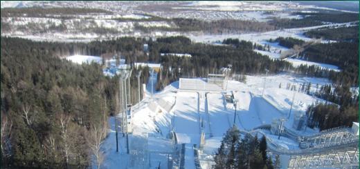
Two wonderful Crimean bays, Golubaya and Kutlakskaya, are separated by the Karaul-Oba rock massif, sometimes you can hear the old name of the cape - Chicken-Kaya. From the village of Novy Svet along a marked trail it is 3.5 km to the top, and from the tourist center in the village of Veseloy it is only 2.5 km. True, the road due to the rise and numerous stops for photo sessions and sightseeing is delayed for a long time.


Origin of names
The toponym Karaul-Oba of Turkic origin, stands for Watch Mountain.The meaning of the name Kutlak is interpreted as follows: the Türkic root “kut” means happiness, and the suffix “varnish” indicates that there is a lot of subject. Thus, "Kutlak" is a place where a lot of happiness is collected. It is not for nothing that the Valley of Paradise is located nearby.
Walking to the Karaul-Oba rock
This route is not difficult, even young ladies ascend along a well-marked path. Steps have been cut on steep sections. The ascent begins near the juniper grove or from Cape Kapchik in the village New World... There are many paths, they sometimes converge, then again gather into one. Step up, don't miss!

Advice:
although there are people in beach shoes and clothes along the way, it is better to take care of the equipment. Trekking shoes or sports shoes, headwear and shorts will make you feel comfortable. Take your camera and water bottle with you.
All the way there are excellent observation platforms, bizarre pine trees and junipers. The road rises smoothly, higher and higher.
- Here is Golitsyn's throne. Good photos are taken here.
- Further descent to the Kholodnaya cave, from where permafrost blows. You can get there only with special caving equipment.
- And here the roots of the trees intertwined and got an intricate ladder, worthy of your attention.
Where the Valleys of Heaven and Hell meet
You will recognize the Glade of Hell by the pile-up of terrifying stones. Go to the cliff and admire the beautiful seascapes: Cape Kapchik, Cape Meganom in the distance, Golubaya (Tsarskaya) Bay. Emperor Nicholas II bathed here during a visit to Prince Lev Golitsyn and his estate Paradise (modern New World). The exit from the Valley of Hell is guarded by two rocks called the Devil's Horns.
Further, at the bend of the path, look carefully to the right. The main path leads to the Kutlak Bay, and a crushed stone path goes up to the right. Follow it to Paradise Valley and Vigil Peak ( modern name Peak of Cosmos). This modern name was invented for another observation deck. Again you can admire the scenery and take pictures.
Video review Karaul-Oba
How Karaul-Oba helped the ancient Taurus
A little more, and you will climb to the top of Karaul-Oba, the height seems to be small, 342 m, but the views from the cliff are excellent. Every weather and lighting creates interesting effects. On the way you will come across numerous crevices and caves, under your feet are the remains of ancient Taurus stairs. When the Crimea was attacked by Roman legionaries, the locals had to leave the fertile lands and hide from the enemy in the mountains, arranging dwellings in caves. The Taurus not only hid, but also attacked the barbarians, used the Karaul-Oba rock to observe enemy troops and set up signal fires.

Returning to the marked route, follow to Veseloe. Another interesting stone at the end of the path is the Sekira rock. To some, it really resembles a tool in shape, and someone sees in it a mushroom cut in half. In a few hundred meters the trail will lead to the recreation center "Marianida".
Inspection of the ancient Kutlak fortress
If you are lucky, then on the descent from the camp site, you can inspect the remains of the walls and defensive structures of the ancient fortress. It was located on a natural terrace, about 70 m above sea level. The Kutlak fortress is the oldest fortification in Crimea, dating back to the reign of the Bosporan king Asander. Her remains were discovered by archaeologists relatively recently, in 1982. It is believed that the fortress defended the borders Bosporan Kingdom from barbarians and sea pirates 2,000 years ago, at the turn of the old and new era. The ancient fortress had a quadrangular shape with watchtowers at the corners. The height of the preserved walls is up to 4 meters.
After resting in the village of Veselom, go back ...
How to get to the Karaul-Oba rock
If you are about to commit walk along the rocky massif Karaul-Oba, then you need to get to the village of Novy Svet. Minibuses from the city of Sudak follow here every hour.
Another option is to start the route in the Veseloye village. Whichever option you choose, you will have to go further on foot, there are no highways to Karaul-Oba.
Karaul-Oba on the map of Crimea
GPS Coordinates: 44 ° 49'21 "N 34 ° 53'36" E Latitude / Longitude
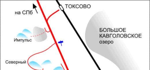
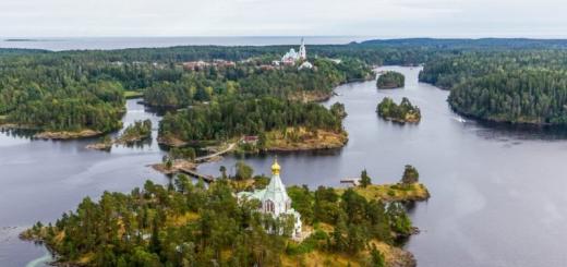
On the territory of the Novy Svet botanical reserve between the village of Veseloe and the village of Novy Svet there is Mount Karaul-Oba (Patrol Peak) - a mountain 341 m high, considered a geological wonder of the world. Start driving along tourist route leading to the top, can be from the side of either of these two settlements, but more interesting from the side of Vesely - from the Kutlak Bay.
Karaul-Oba is an ancient coral reef with complex geomorphological characteristics. An exposed conical summit is located in the northern part, to the south is a plateau-like massif with rocky walls, ridges, crevices: the teeth of the cliffs rise above the sea. If you look closely at the rock, you can see coral colonies, imprints of shells and molluscs.
Climbing higher and higher to the gates of "hell" - a narrow passage between the rocks, behind which is a valley surrounded by stone walls. In these places, archaeologists have discovered ancient settlements of the Bronze Age dating back to the 2nd millennium BC.
One of the rocky crevices in the northern part of the valley is popularly referred to as "refrigerator": even in the very heat, cold blows from it. There is an opinion that ancient people could use this place to store their supplies.

From "hell" the traveler enters "paradise" - a valley overgrown with juniper. On the way to it, you need to overcome a steep rise, in the middle of which there is a small viewpoint- "Golitsin's chair". It was from here that the owner of the Novosovetsky estate, Prince Lev Golitsyn, admired the surroundings.

Continuing the path, we reach the stone staircase of the Taurus, carved into the rock. Through the "Adam's bed" - a narrow and dark gorge - the steps lead to a spacious platform with a beautiful view of Cape Kapchik. Relic trees grow around - junipers and pistachios, whose age reaches 500 years.
On the western spurs of Mount Karaul-Oba, there are the ruins of the Bosporus fortress built in the first century BC. Going down to the water, we find ourselves on the Tsarskoe beach - it got its name after the visit to the New World of Emperor Nicholas II, who was resting on this part of the coast.
The central Sudak beach is 2 km long and stretches from Mount Alchak to the Fortress Mountain. The cover is sandy and pebble, the beach is wide enough and convenient for tourists. Shops and restaurants are located along the entire city promenade.
Karaul-Oba - video
Part one: Verkhoyitskaya pier
The oldest city in the Chelyabinsk region is Verkhneuralsk. Today it is a small, quiet town, and during the XVIII-XIX centuries. he played an important role in the history of our region. And his history is rich in various episodes - tragic, heroic, ordinary, simply interesting. Before proceeding with the narration, I would like to recall the wonderful local historian - Ivan Vladimirovich Degtyarev. It was he who, at one time (back in the 1960s – 1970s), collected in various archives a huge amount of various information, which formed the basis of my story. I supplemented his information with newly revealed materials.
Let's start in order, from the founding of the city. In 1734 the Orenburg expedition began its activity. It was formed through the efforts of the Chief Secretary of the Senate IK Kirilov. The primary tasks of the expedition are the construction of the city of Orenburg and the pier on the Aral Sea. Promising areas of work - the establishment of trade routes to Central Asia, exploration and the beginning of the development of local natural resources, the beginning of the development of ore resources South Urals... The first Orenburg (today the city of Orsk) was planned and was laid down at the confluence of the river. Or in the r. Ural, hence the name - Orenburg, that is, "city on the river. Ori ". The initiators of the construction of the city (at least formally) were the Kirghiz-Kaisaks, that is, the Kazakhs. They needed this city for trade and as a symbol of the presence of a powerful ally in the steppe. True, the author of the project, I.K. Kirilov tried to attribute the desire to build new town and the Bashkirs, but this is a controversial point. In this case, we will not go into nuances, but, by all accounts, the activities of the Orenburg expedition provoked a Bashkir uprising, which called into question the fulfillment of its tasks.
In the fall of 1734, the expedition arrived in Ufa, and here Kirilov learned that the place where the city of Orenburg was supposed to be founded was far from Ufa and there was a problem of supplying the new city with supplies. It was not possible to bring the necessary supplies to the Sakmara town by winter route, so that from there then they could be delivered to the construction site. It was necessary to look for another option. December 15, 1734 (old style) I.K. Kirilov wrote to the chief chief of the Kazan and Siberian factories V.N. Tatishchev: “in the land map, it means that the peaks of the Yaika River (today - the Ural River) have approached the Siberian and Yekaterinburg settlements and factories, from where everything that is needed can be found, establishing a convenient pier and then transporting it in the winter way, and in the spring with the first water on rafts ". Further, the head of the expedition asked Tatishchev, if he knew the situation in the upper reaches of the Yaik, to send proposals on how it would be more convenient to organize the delivery of tools and food supplies to the place where it is more convenient to build a pier, from the Yekaterinburg department. “If Your Excellency does not know about the peaks, then I ask you to send from the merchants and with them secretly, instead of the clerk, a surveyor, who would go around the necessary places and inspect where the pier and then make a drawing, or rather,” wrote I.K. Kirilov. Tatishchev, having received a letter, sent the Yekaterinburg merchant Ivan Kharchevnikov to the "heights" of Yaik, and with him sent the surveyor Ivan Shishkov, ordering him to take an assistant ("student") with him. They had to find a place in the upper reaches of the Yaik or some tributary, convenient for building a dock, from where they could send supplies on rafts down the river in the spring. In addition, they had to contract the "Tatars" who lived there (meaning the Bashkirs - in the documents of that time they are often called Tatars) to build sheds for storing food and prepare timber for rafts. In addition, "Shishkov can help him to reconnoiter the position of those places and make a drawing while looking at it." On January 2, 1735, two Ivans - Kharchevnikov and Shishkov - went to Yaik.
Meanwhile, I.K. Kirilov is informed that a place for the pier has been found. On December 31 (according to the old style), he wrote to Tatishchev: “now I have received genuine news that it is possible to float with rafts and ships from the mouth, where the Ulzhede (Urlyady) river fell from the Siberian side, and on that river in the top of a pine and other forest for the business of courts and there are enough rafts and that forest is called Oktu (Okto-Karagai - Karagai bor), behind Horoshaeva village, a day's drive, about sixty versts. Tarkhan Taymas batyr Shaimov undertook to build the pier which Tarkhan Taymas batyr Shaimov undertook to build the Siberian road of the Karatabynsk volost, and already bought a thousand pounds of bread or more in Siberian settlements through another Bashkir Bokchurga ... " In this connection, he asked to send tools: axes, scrapers, crowbars, drills, etc. to the village of Khoroshaeva, so that "as soon as a soldier of a company from Ufa comes, they will take huts and barns or sheds to the place shown" ... In addition, he reported that the admiralty ship masters would also go to the pier (such were the expedition, let me remind you that one of its tasks was to build a pier and ships on the Aral Sea). The problem was different, these craftsmen "did not have the case of simple ships", that is, they could build a sea vessel, but a simple plank is not a fact. Kirilov noted that Tatishchev had enough of such masters and asked to send two or three people "in the first case, send them, they can discern the water, and make such vessels." That is, to build barges, proceeding from the high flow of the river, so that they do not turn out to be too large for the upper reaches of the Yaik.
A day earlier than Tatishchev (that is, December 30, 1734), Ivan Kirillovich wrote a "most humble report" to the Empress Anna Ioannovna. And in it he says that “on a parcel from me by the Bashkir foreman of the Siberian road ... Tarkhan Taymas-batyr examined and permission from the Bashkir estate owner ... He took the name Good ... For the guard and the building on the first case of a small store and slingshots, making for courts and rafts forests, sent a company of soldiers, sent a ship's foreman with carpenters and other artisans there, and by the spring I will send another company. " That is, Kirilov presents the matter to Vasily Nikitich as it is, and to Anna Ioannovna he reports on the successes - they say the consent of the Bashkirs living on the Yaik has been received and the company has already been sent to the site, and practically the pier is already being built! It is on the basis of this report that the foundation of the Verkhoyitskaya pier is dated 1734, although nothing was laid yet, and the Bashkirs living in that area did not give consent to the construction, and even a detachment to Yaik from Ufa has not yet come out ... However, about this and that, How did events develop further, the story is ahead.
Map of the Ufa province from the Atlas of the Russian Empire, published in 1745. However, the situation of the Southern Trans-Urals, displayed on this map, corresponds to 1735, that is, the time when the Veroyaitskaya pier was laid. But other fortresses, except for the first Orenburg (Orsk) and Ozernaya, have not yet been built.
Ivan Shishkov with the merchant Kharchevnikov on the 11th day after leaving Yekatinsk (as Yekaterinburg was called during the "reign" of VN Tatishchev) got to the very village of Khoroshaeva (Karashaeva) and found out that everything was not so smooth. The owner of the village, Bashkir Karashai, said that he would not give a place for building sheds and storing timber for rafts: “And this Karashai told us that when the Nogai road the Bashkirians will miss the provisions brought from Ufa to the Cossack town of Sakmaru to prepare for the newly built city of Orenburkh, then and I will willingly give you that place. " Also, there were no people to build sheds in the village, but Karashai said that if everything is normal and the Bashkirs of the Nogai road let the train from Ufa to Sakmarsk pass, he will give empty huts and sheds in the village for warehouses. Shishkov also noted in his report that on the way from Yekaterinburg to the heights of Yaik "there is a great scarcity of canyons ... you cannot hire carts either."
Conclusions from the report of Shishkov Tatishchev made almost instantly. On January 24, he receives a surveyor's report and, it seems, immediately gives an order to the peasants of the Bagaryatskaya Sloboda - to go to the Tabynsk volost “to find out about Lake Chebarkul, what is it, and to whom? And if it is possible, to hire it for a settlement, allegedly for yourself. " The peasants of the Bagaryak settlement Trifon Karandashev and Semyon Yushkov set out. There were no Bashkirs on Chebarkul, they moved for the winter to the upper reaches of the Uy River (modern Uchalinsky district of Bashkiria). When they got there, the peasants talked with the Tabynts (Tabyn is one of the groups of tribes within the Bashkirs) about leasing the lake for 5 years and the possibility of building a village. The Bashkirs said that it is possible to take the lake at the mercy, but "we dare not give land to the peasants in our places, fearing Her Imperial Majesty's decrees ...". It turned out that at that time the lake. Chebarkul was given to the peasants of the Dalmatov Monastery for 20 rubles a year. To the proposal of the Bagaryak peasants to lease the lake from next year to them, the Bashkirs replied that, in general, they did not mind, but now not all patrimonials (that is, the Bashkirs are the owners of that land) are in place, when everyone is assembled, then they say let them come and agree. It would seem, why did Tatishchev need a Russian settlement on Chebarkul? The whole point is the very absence of places where you could buy hay and change horses, on the way from the Russian settlements to the upper reaches of the Yaik ...
The troubles of the Orenburg expedition went on as usual. Ensign Gladyshev traveled around the settlements and bought flour and cereals for the needs of the expedition. Kirilov was in charge. On January 29, he wrote to Tatishchev that he had been shown two more places where a pier could be built. He assigned one company each from the Ufa battalion and the Kazan regiment to be sent to the construction site, but they were still in Ufa, awaiting the arrival of I. Gladyshev, who knew "where would it be safer for them to come to the inspected place." Since Gladyshev left the Techenskaya Sloboda no earlier than February 23, the soldiers from Ufa to Yaik did not move until the end of February. The instruction to Captain Uvarov and Lieutenant Vetoshnikov, who commanded the first company sent to Yaik, was signed on February 21, 1735. Consequently, they left after that date. In a letter dated March 30 to Tatishchev, the head of the expedition informed that "the pier of Verkhoyaitskaya, I hope for a true God, will establish itself and there the first company in a strong place turned around with slingshots, and the other company and the admiralty servants went from here on March 16 ...". Thus, the Verkhoyitskaya pier was actually founded in February-March 1735. Although it is usually customary to talk about the year 1734 - this year is officially considered the date of the foundation of Verkhneuralsk. But this is such a historical delusion - it has been said for a long time that this date is not correct, but since 1734 is earlier than 1735, it seems to the residents of Verkhneuralsk somehow more interesting as the year of foundation of their city (and not only to them). This is generally a common phenomenon. In Chelyabinsk, they regularly try to revive the theme of the mythical "Aleksandrovskaya Sloboda", which supposedly was the predecessor of the Chelyabinsk fortress, but was supposedly built at the end of the 17th century .... Ufa residents do not want to give up 1574, as the first year of the city's existence, although it seems like it has long been proven that Ufa was founded in 1586.
Part two: The history of the winter convoy
The company of the Ufa garrison regiment commanded by Captain Uvarov and Lieutenant Vetoshnikov was the first to arrive at the site of the future Verkhoyitskaya pier. Then a company of the Kazan regiment approached, commanded by Captain Koryagin and Warrant Officer Ignatiev. They built the necessary storage and living quarters and a fortress, since the mood of the Bashkirs was not at all peaceful, which is not surprising. In the summer of 1735, the uprising had already engulfed the central and southern regions of Bashkiria. And then it spread to the Trans-Urals.
The sent detachment did not have the opportunity to build a normal fortress - two companies are clearly not enough for this. Forts of the Miass or Chebarkul type were built by detachments, in which there were 2-3 thousand people (including peasants). And it is simply unrealistic to fill the normal earth shafts with the forces of soldiers of two companies. There is nothing to put a wooden patch on. A normal forest grew 30–40 km from the pier. Remained ... willow rods, i.e. and you. Soldier Devyatkov later said that one of the groups of fighters went to cut the teller for "rounds", that is, for the manufacture of wicker tall cylinders, which were covered with soil or other ballast. P.S. Pallas wrote in his notes in 1771: "Nearly living Tatars and Bashkirs, the upper Yaitskaya fortress is still called" Talkallar "[a false fortress], because at first it was surrounded by a fascinator like a rampart". "Talkallar", more precisely, "talkale" and means "talnik city", fascinator are just rods, usually tied in bundles such as sheaves. However, no matter what its walls were made of, the rebellious Bashkirs did not dare to storm it ...
The further situation was largely determined by whether food supplies from the Siberian settlements would be delivered in a timely manner? Therefore, I will tell you in detail how the situation with the delivery of food developed. The very first train, sent from the Techenskaya Sloboda to the Verkhoyitskaya pier and further, to Orenburg, in the summer of 1735, was blocked by the Bashkirs near the lake. Ukly-Karagay. Units of the Siberian and Orenburg dragoon regiments arrived in time and freed the wagon train, and the products were delivered to the builders of Orenburg. But the supplies delivered were not enough to feed the garrisons until spring. Another wagon train was supposed to arrive in winter, but they did not wait for it in Orenburg and the Verkhoyitskaya pier ...
Even before the convoy left, in November 1735, reports began to arrive that the Bashkirs of different volosts said that "as soon as the provisions go to Orenburg, they will certainly be smashed and they will not be allowed to reach Orenburg." Captain Uvarov reported the same from the Verkhoyitskaya pier. V.N. Tatishchev sent a decree to Colonel I. Arsenyev, in which he suggested that he escort the train to safe place... The wagon train departed from the Techenskaya Sloboda on December 2, accompanied by a detachment of dragoons and infantry of 357 people, under the command of Major M. Shkader. In addition, there were 600 peasants with carts. And ... I fell into the same trap as the summer train. But if in the summer of 1735, as A.I. Tevkelev, the team accompanying the food was attacked by a detachment of Bashkirs numbering about 260 people, then in winter there were several thousand of them. I will leave the further narration to contemporaries and participants in the events - the documents written by the officers of the Siberian Dragoon and Yenisei Infantry Regiments are eloquent and quite artistic in their style of presentation. Although the "effect" of artistry probably arises from the drama of the events described. Before proceeding with the exposition, let me remind you that any violators of the law were called "thieves" in those days. Those. the word "thief", which will often be found in documents in relation to the Bashkirs, denotes the Bashkirs who took part in the uprising. Because the uprising, according to the logic of the state, is an illegal act.
The first report of Major Shkader about the attack of the Bashkirs on the train is not dated, most likely, it was written on December 23, 1735: “... from the Techenskaya Sloboda we departed this December 2 days in 1735 and walked in Bashkir veins, and this December 22 days near the Yanbiki River from the enemies of the Bashkir thieves we sit otakovka ... and these Bashkir thieves with a thousand or more ... it is impossible to go from the spot, they came (to) stone mountains and between them there is only one rope (ie in one column, single file) ”. The wagon train stretching between the mountains is an ideal object for an attack, of course, Shkader did not dare to take such a suicidal step. The fact that the Bashkirs attacked Shkader's team not in the gorge, but before entering it, out of the blue, may indicate an unwillingness to destroy the baggage train. Although it is possible, just someone's nerves could not stand it, and the attack began earlier than planned. Further development of events is described in Shkader's report of January 24: “... not after (to the Verkhoyitskaya pier), the Bashkir thieves near the Anbi river attacked, and there was a strong battle on December from 22nd to 24th, but this year, 1736, from January 6th from morning to evening. On which the battles were beaten: the Yenisei regiment was two saldat, one ferchel; wounded: one corporal, two saldat, two saldat of the Tobolsk regiment, and five different peasant settlements, one Yasashny Tatar. In total, eleven people were wounded ... About what they wrote to his high nobility, Colonel Ivan Savich Arsenyev, so that he would follow with the command to the securs (for securs, which means to join - GS) ... ".
So, Shkader with food was surrounded and was waiting for help from the Siberian Dragoon Regiment, headed by Colonel Arsenyev. But no help came. A fragment from a report to Tatishchev, written by Arsenyev on January 20, 1736, tells about why the wait was in vain: “this year 736 is 4 days ... the Siberian Dragoon regiment with cash people, with five hundred and seven people, and the Okunevsky district with ninety peasants. , who many did not have a gun, set out from the Techinsky settlement on a march to rescue the Bashkir thieves from the bureaucratic governor, near the Yanbiki river, sent from the Techinsky settlement to Orenburkh with Maeor Shkader ... Pravianta not reached fifteen miles away, the thieves of the Bashkir Siberian and Nagai roads, Yusup and Zhiyanbai, in a crowd of thousands of heels and more, packed us from all sides and approached us with a cruel attack, and there was a battle with them from half a day to the evening and the whole night and the next day the third on the tenth (thirteenth) day from morning until evening. And in that battle killed: six dragoons, one peasant; wounded ... forty-five people ... ". Then the colonel explains: it was impossible to line up battalions in squares and attack on foot, “because great rocky mountains and the most cramped places came - in one sled with difficulty to pass, but he adhered all the food to the state horses, ... and from the lack of fodder for the horse in the otaka were dying. " It would seem that some kind of overkill - why would horses die? It turns out that the peasant carts from the settlements were not sent on time and the dragoons were forced to harness their battle horses in the sledges with supplies. And since they were marching quickly, the horses, naturally, were exhausted, “and all the cavalry should have been a dragoon for a quick march and from the attack of an enemy dangerous case ... and during the thieves' attack described above, the dragoons would have unhitched horses (from the carts) for battle. ".
If Shkader was surrounded in front of the entrance to the gorge, then Arsenyev's detachment was attacked already being drawn into the ravine. The situation is stalemate - there is no food for the horses, no food, the ammunition is almost exhausted in two days of battle, the enemy is on the peaks and slopes of the surrounding mountains, and you can only drive along the road in single file ... , Bashkir thieves began to ask an interpreter for a negotiation. And the Bashkirians who were with us in the otak were sent to them from us: the Siberian road of the Salzautsk volost Isengul Lushnikov, the Balakatai volost Abdula Kachkin. And at the conversation, Yusup and Zhyambai told them that: we would not let the colonel and the people until the forged praviant pass, but if he goes ahead, we’ll be a drat, and to the last person we will all die here on our land, We will not allow the Verkhoyitskaya pier ”. And in conclusion, the colonel reported: "January 14 days from the current march, from the otaka, for the scarcity of people and for the violent thieves' attack, and for a lot of harm to people and horses, and for the lack of a praviant and fodder, they returned to the Techin settlement."
Arsenyev's first message about the failure of his campaign, sent back on January 16, aroused Tatishchev's anger. On the same day, when Arsenyev was compiling a detailed report, which I quoted above, Vasily Nikitich sent him a stern "order", where it was stated that "the baggage train with the Praviant and supplies was left to the enemies for destruction", and then it was about measures to save the baggage ... But measures are already overdue. According to Shkader's description: “on leave of this lord colonel (Arsenyev), the Bashkir thieves let the thieves go for another five thousand otaku and wanted to break it. And at the meeting room, these Bashkirians announced that the thief Yusup and his comrades did not want to let the de Praviant wagon train further than this place, and if he went ahead or stood there, then we would definitely break it up and not let it pass. And if you go back, we will give amonats (hostages) and honor them. And on this January 16th day of the sent companies, the headquarters and chief officers signed to accept the Amonates, and instead of them give their own Amonates, from the Russians, and return. And at the dacha of the Amonates they returned, after all we had gunpowder, both cannon and weapons, therefore there was nothing to belittle (that is, not enough) and the enemy (to fight) with them had nothing. And this January 23 days all arrived safely in the Techenskaya Sloboda. "
As far as can be judged, the hostages were released by both sides after the arrival of the convoy back to the Techenskaya Sloboda. At least, I did not come across documents where it would be mentioned about non-compliance by the parties with obligations.
Part Three: The Destruction of the Wharf Garrison
After the return of the convoy with food to the Techenskaya Sloboda (today the village of Russkaya Techa), in the report of V.N. Major Shkader told Tatishchev: “only the Bashkirian Kinzyakey Akynchikov wanted to declare his faithful service to Her Imperial Majesty to the Karatabynskaya volost, and undertook to send the Bashkirians from the thieves secretly, so that they could not lead the government governor to the Verkhoyitskaya pier, twenty-two carts ... only 323 poods.” Kinzyakaya's decision was quite understandable - the garrison of the Verkhoyitskaya pier was starving. Almost all the products delivered by the previous wagon train were sent to the Orenburg under construction, and there was almost nothing left in the fortress. But nothing is known about the fate of this small convoy, we can only make assumptions, but more on that below.
For a long time there was no reliable information about the fate of the Verkhoyitskaya pier. Apparently, Kinzyakey Akinchikov disappeared along with the wagon train, which he undertook to deliver to the fortress. In February, the officers of the Siberian Dragoon Regiment began to receive scraps of conflicting information, which were reported by Tatars and Bashkirs, who had heard the stories of other Bashkirs who lived closer to Yaik. One message said that “they heard (that) the people found on the Verkhoyitskaya pier were all beaten by the Bashkir thieves, and they took the shell, cannon, gun, gunpowder and other supplies for themselves. And they committed the thieves in this way: when they arrived at that pier and announced that they had sent flour with them to go from the Verkhoyitskaya pier to the city of Ufa, and they de Bashkir butto were ordered to escort them, and having lured everyone along the way, they beat them. And where was that flour sent from and by what occasion, he was not told ... ”.
Another said that “the future Saldat on the Verkhoyitskaya wharf, for lack of a Praviant and enduring great smooth need, the Bashkirians Ajigit da Emet and their comrades in three hundred people took the Nagai road from the Nagai road, and took them to the city of Ufa on carts, which they gave under saldat. Nagai road Bashkir Karabay, and how many saldats and for them supplies were given and whether hired or not I did not hear about that, and the aforementioned Bashkirs Ajigit da Emet and all three hundred people in the fact that to bring them all to the city of Ufa safely, according to their faith, came to wool and they kissed Kuran and signed it, and left the guns with the Bashkiretin at Zhinbai. "
The third one again stated the worst option: “the thieves of the Bashkir people of the Kumratsk volost of Tokchur from the goods and the chief scammers and saldat, who were available on that pier, came to the Verkhoyitskaya pier of the Siberian road and lured them to the Verkhoyitskaya pier of the Siberian road, lured that about ten days and gave them hope to escort them to the city of Ufa along the road they came and beat everyone ". It was clear that the dock no longer existed. Already in March, in the instructions given by V.N. The Tatishchevs suggested that Colonel I. Arsenyev try to restore the Verkhoyitskaya pier, or rather its fortification.
And in the summer, near the Sinara River, a soldier Semyon Mokeevich Devyatkin, who had escaped from captivity, was found, it seems, the only survivor from the garrison of the Verkhoyitskaya pier. His story surprisingly includes both versions, which reached the officers in the retelling ...
Since the fall, the pier was actually under siege - the surroundings were controlled by detachments of the rebellious Bashkirs. There is no food left. Sometimes the Bashkirs who did not take part in the uprising, at the risk of their lives, delivered something of the food. By the winter, the situation worsened, and after the winter wagon train with food was blocked in the Karagai pine forest and deployed back to the Techenskaya Sloboda, the leader of the uprising, Yusup Arykov, came to the pier with the main detachment. By this time, there were no food at all, the soldiers reached the point of eating carrion, many were sick or simply exhausted. Arykov suggested that the garrison leave for the "Siberian settlements" and promised unhindered passage and assistance with horses and food, but the garrison commander did not agree. As it turned out, he did the right thing ... At the beginning of February, Arykov sent "the best people" for negotiations. foremen. Ten people were allowed into the fortress to listen to their suggestions. The foremen repeated Yusup's proposal, saying that otherwise the garrison would simply starve to death. Captain Uvarov set the condition "if you take the oath and kiss the Kuran that you will escort us safely, then we are ready to leave the fortress." Bashkirs (the same the best people sent by Yusup Arykov for negotiations) took an oath on the Koran. The next day, 200 horses with sledges were driven, into which they loaded weapons, ammunition, the sick - the healthy ones went on foot, and moved towards the settlements, i.e. to the East. But the very next day it was said that they would not be allowed into the settlements and that they had to go back to Ufa, the same road that they took to Yaik ... Apparently, the foremen, who had taken the oath, seeing that the people were taken to where they had been promised, dispersed to houses, and Yusup decided to turn things around in his own way.
I will not retell the twists and turns of this tragedy. It stretched out for several days. Almost all the soldiers of the two companies were killed. The wounded, whom the captain Uvarov left in one of the villages (the soldiers' sledges and horses were taken away, and it was impossible to carry the wounded and frostbitten ones, who were also left without warm clothes), the Bashkirs took them home, into workers. One of them was Semyon Devyatkov, a 24-year-old soldier. After some time, he ran away from the "owner" and told the story of the death of the garrison of the Verkhoyitskaya pier. True, the ending of this story took place without his participation.
It can be assumed that Kinzyakaya Akinchikov's wagon train was intercepted by Yusup's detachments, and the bread wagons were used as a kind of additional argument in negotiations with the garrison of the fortress. At least, such a version is possible, based on the stories of some of the Bashkirs, cited above.
Until 1738, the place where the pier was built was empty ...
Part of the worm: Tatishchev-2-Tatishchev, or the second birth of the Verkhoyitskaya fortress
In 1737, the head of the Orenburg expedition, Ivan Kirillovich Kirilov, died, and Vasily Nikitich Tatishchev was appointed head, instead of him. Moreover, it was no longer an expedition, but the Orenburg Commission. And in the fall of 1737, at the suggestion of Vasily Nikitich, the Trans-Ural Isetskaya province was established and its governor was appointed to take Vasily Nikitich - Ivan Nikitich Tatishchev. As a governor, Ivan Nikitich carried out his brother's project to equip fortresses along the road that led from the Siberian settlements to the Verkhoyitskaya pier. And first of all, it was required to rebuild the Verkhoyitskaya fortress itself.
In the summer of 1738, a detachment under the command of the governor of the Isetskaya province, Colonel I.N. Tatishchev (brother of the famous statesman and historian V.N. Tatishchev) and the commander of the Siberian dragoon regiment, Colonel I.S. Arsenyeva comes to the upper reaches of the Yaik and, one verst from the burnt-out first Verkhoyitskaya pier, erects a new fortification. As Colonel Bakhmetev wrote in 1742 in his report: "Verkhoyitskaya was built in 738 in July by the same gentlemen Colonels Arseniev and Tatishchev, earthen with turf, in it a garrison of regular and irregular one hundred and fifty people." Another document deciphers these numbers: "in the Verkhoyitskaya dragoons of the Siberian regiment there are fifty-five, saldat of the Tobolsk forty-four, the Yenisei three-four, eighty-eight serving Russians, twenty-eight Tatars." Of course, the fortress was being built for several months and the work was completed only by the end of August.
From the headwaters of the Yaik, the detachment went to the Ukly-Karagai lake, where in 1736 it was planned to build a fortress. It was near this lake that the food wagons were attacked, which went from the Techenskaya Sloboda to the Orenburg under construction in July and December 1735. Therefore, the fortress was needed here to control the road, about which food, tools, etc. continued to flow. Let's refer to the same report Bakhmeteva: "Uklykaragai was built in 738 in August and September by gentlemen colonels Arsenyev and Tatishchev, earthen with turf with a front garden, in it there is a garrison of regular and irregular one hundred and fifty, twelve people who settled from peasants into Cossacks." And the decoding of the garrison: "... in the Ukly-Karagai dragoons of the Orenburg regiment, sixty-eight, saldat (Tobolsk and Yenisei regiments - GS) sixty-four people, fifty-nine serving Russians, seventy Tatars."
The garrisons in the fortresses were set up mixed, they included dragoons (cavalry units), soldiers (infantry units) and service people from Siberian cities. Servicemen, otherwise called city Cossacks, consisted of Russians and Tatars. In the first fortresses, built in 1736-1737. was typed a large number of Cossacks from the peasants of the Trans-Ural settlements. They made up the main population of the Chebarkul, Miass, Chelyabinsk and Etkul fortresses. As you can see, there were 12 such people in Ukly-Karagayskaya in 1742, and in Verkhoyitskaya there were none at all.

Fragment of the map of the Isetskaya province of 1742, which shows the newly built fortresses: Verkhoyatskaya, Ukly (Ukly-Karagayskaya) and Uiskaya, as well as Etkulskaya.
After the construction of the Ukly-Karagai fortress, the only thing left was to “fill” the space between it and Chebarkul. A place to build a fortification on the river. Uy was appointed, along with others, back in 1736, but the Uy fortress itself was erected only in 1742. The fortresses had fortifications characteristic of that time - square in plan, with an earthen rampart, with corner bastions. The external fortifications of the fortresses were an earthen rampart (Verkhoyitskaya), a rampart with a palisade (Ukly-Karagayskaya), or just a wooden wall, as Uiskaya was at first fortified. In Uiskaya, a wooden float was set up, marking out the area for filling the earthen rampart, which was built later. I. Gmelin left a description of the Verkhoyitskaya fortress in 1742: “The fortress is a regular rectangle with a bastion in each corner. Each side from the outer corner of one bastion to the outer corner of another bastion has 80 fathoms and consists of a high earthen rampart ... From the side of the reservoir and from the north there are gates with an entrance, and above them are shooting towers, each of which is equipped with a battery. Outside, the fortress is surrounded by a deep moat , behind which there are slingshots, which adjoin the river on the southern and northern sides. Inside the fortress there are 2 houses for senior officers, an office, a powder and vodka store, 5 granaries and 22 barracks. Now inside the fortress, a church is being built in honor of the Annunciation of Mary, which was founded on June 28 ”.
It seems that it was in 1743 that an expanded system of border protection began to form. The fortresses themselves acted as strong points of the border line, and the distance between the fortresses also had to be controlled. For this purpose, outposts were initially set up (relatively small fortifications, where the border patrol could fight off the enemy's attack) and beacons - signal towers from which it was possible to send an alarm signal in case of danger. Guards (pickets) were on duty at these towers. The territory between the fortresses was controlled by patrols (like the modern border guard). There were also "departing patrols", that is, groups of military men who went to the steppe to monitor the situation, in modern language this can be called "intelligence". In June 1743, the governor of the Isetskaya province, who was also the commander of the Orenburg dragoon regiment, Colonel P. Bakhmetev wrote to the Miass and Chebarkul fortresses: “... patrols have already been established from Verkhoyitskaya through the Uklykaragay and Uy fortresses and at the lighthouses, missing the Etkulatskaya fortress and Chumlyatskaya settlements, to Tobol, with which both the Chebarkulskaya and the other fortresses along Miyas are covered. "
In the same June 1743, Prime Major M. Shkader sent out to the fortresses "proposals" for increased readiness at the "established outposts", where he ordered the commander of the Uisk fortress, Captain Polozov, “to send the beacons and figures available at the Uyskaya fortress [obra] to the Verkhoyitskaya the fortress immediately (...) according to these, beacons and figures on the departing guards, where appropriate, at the Verkhoyitskaya fortress have to be (made). " The words "beacons" and "figures" in this case mean sets of signs, signals with the help of which it was possible to transmit messages at a distance, within sight. Therefore, signal towers, which were also called "lighthouses", were placed on hills, hills, so that the signals could be seen from afar. The lighthouses were placed within the line of sight, at such a distance that it was possible to discern which "figures" were shown on the next lighthouse. In the case of the Verkhoyitskaya fortress, natural heights served as lighthouses. I. Gmelin, who visited here in 1742, wrote: “One post is located on a mountain called Ak-Tyude (50 fathoms above the fortress, and 3 versts from it on the western bank of the Yaik), another on Mount Koshtak-Tyube , which is located 4 versts east of the fortress near the eastern bank of the Haud Uidyak. The third is 6 versts south of the fortress down the Yaik, on the Karaul-Tyube mountain, so called because of the guard that stood there in the past Bashkir times. " He also pointed out that “Outside the fortress, on its western side, near the river, there are 15 almost ruined barracks for the Bashkirs that are at the outpost. Consequently, the system of external security existed practically from the very construction of the fortress in 1738, and the Bashkirs served there, along with soldiers and Cossacks. I don’t know what the “figures” and “beacons” were, perhaps they were made in the likeness of the “figures” used (and still used) in the navy.
Thus, a new border line was organized and Chelyabinsk, Miass, Chebarkul was in the "rear", inside the territory outlined by border fortresses.
Part Five: Arrangement of the Border
The formation of the first border line did not cancel the original function of the fortresses - they were set up as staging points on the road along which food was delivered to the Orenburg under construction. The Verkhoyaitskaya fortress, as planned back in 1735, was a storage place for supplies: in the winter, along the sled route, the products were transported there, and in the spring, by high water, they had to be sent down the Yaik (Ural). And to prepare hay for the Verkhoitsk, Ukly-Karagai and Uy fortresses, Cossacks were dispatched from the Chelyabinsk, Miass, Chebarkul and Etkul fortresses. Moreover, in Ukly-Karagayskaya in 1743 there were 17 “own” Cossacks, in Uiskaya - 35, and in Verkhoyitskaya there were still no Cossacks. And a lot of hay had to be prepared, in Verkhoyitskaya - 40,000 kopecks, and in Ukly-Karagayskaya and Uyskaya - 30,000 kopecks each. Each shock is not less than 5 pounds, i.e. 80 kg. hay. It is characteristic that the preparation of hay was equated for the Cossacks with the line service, that is, with duty at border outposts.
In 1743, I.I. Neplyuev decides to build fortresses along the Uy and Yaik rivers. The previous version, when the line was Verkhoyitskaya, Ukly-Karagayskaya, Uyskaya, Etkulskaya fortresses and Chumlyatskaya Sloboda, was far from optimal, since the gaps between the strongholds were too large and it was unrealistic to cover them even with the help of outposts and patrols. We needed a solid border line that would allow us to control the situation. In the same 1743, the fortresses of Magnitnaya, Peter and Paul, Stepnaya, Troitskaya and others were laid. Verkhoyitskaya and Ukly-Karagayskaya, thus, were included not only in the system of "road" fortifications, i.e. built on the road along which food was transported from the settlements of the Trans-Urals to the Orenburg under construction, but also to the newly formed border line. Obviously, soon after this, the Urlyadinsky redoubt was erected between these two fortresses and the Erdizinsky (Erzidinsky) redoubt - between the Ukly-Karagai and Petropavlovsk ones. The Ui fortress was in the depths of the territory, beyond the border line.

Thus, the border with the "steppe of nomadic Kirghiz-Kaisaks (Kazakhs)" initially ran along the Uy and Yaik rivers, and the Ukly-Karagai fortress was a kind of link between the lines located along these two rivers. The system of border protection developed, new redoubts and outposts were set up between the fortresses - fortifications smaller than the fortresses in size, in which there were temporary garrisons. These garrisons included soldiers, dragoons, Cossacks and Bashkirs. Later, detachments of Cossacks, Bashkirs and "service messengers" began to be sent there. Linear service i.e. duty at outposts usually took place in the summer - in winter, the danger of the Kazakhs crossing the border was less, since they migrated to the south, to winter pastures.
The task of the border line of fortresses was precisely to protect the border. Fortresses acted as strong points, and redoubts, outposts, pickets and lighthouses made it possible to effectively guard the border and prevent the penetration of troops from the steppe, or warn of their approach.

Section and "facade" of the lighthouse across Laskovsky. A tower, on top of which there is a keg with something fuel. If danger was detected, a fire was kindled to give a signal.
As the border was arranged, it was divided into "distances" - each distance included several fortresses and redoubts. P.I. Rychkov reports: “This whole line (Uiskaya - GS) is divided into two distances. The first one begins with the Verkhoyitskaya fortress, where the commander of this distance is located. In his own department Ukly-Karagai, Peter and Paul and Steppe fortresses with several redoubts; but in that which belongs to military affairs, it is for the most part under orders (orders - GS) and the instruction of the commander who is in the Trinity Fortress, to whom foreign affairs are also entrusted. " Accordingly, the commander of the Troitsk fortress had general command over the entire Uyskaya line and directly commanded the Lower Uyskaya distance, which included the Troitskaya, Krutoyarskaya and Ust-Uyskaya fortresses with redoubts and outposts between them. However, in the second half of the 1750s. the situation will change: the Nizhne-Uyskaya distance becomes subordinate to the commander of the Zverinogolovskaya fortress, which was previously part of the Presno-Gorkovskaya line, and in 1756 was transferred to the Uiskaya; The Trinity fortress "takes" itself the Verkhne-Uyskaya distance, excluding the Ukly-Karagai fortress. Verkhoyitskaya becomes the center of the newly formed Verkhoyitskaya distance, which included fortresses: Ukly-Karagayskaya, Magnitnaya and Kizilskaya, with redoubts and outposts. In fact, the Verkhoyitskaya distance "closed" the lines of fortresses along the Uy and Yaik rivers.
Dmitriev-Mamonov A.I. The Pugachev riot in the Trans-Urals and Siberia. Historical sketch according to official documents. - St. Petersburg, 1907. - S. 6–7.
Part six: Pugachev walked alongside
Here I will again cite the plan of 1742 and cite the description of the Verkhoyaitskaya fortress by academician Gmelin, who was in our area just this very year: “... The Verkhoyaitskaya fortress is located on the eastern bank of the Yaik River, which flows to the southwest near the fortress, and above - to the southeast.

Verkhnyayaitskaya fortress in 1742
The fortress is a regular rectangle with a bastion in each corner. Each side from the outer corner of one bastion to the outer corner of another bastion is 80 fathoms long and consists of a high earthen rampart that runs along the bastions. From the side of the reservoir (i.e. from the west) and north there are gates with an entrance, and above them are shooting towers, each of which is equipped with a battery. Outside, the fortress is surrounded by a deep moat, behind which there are slingshots, which adjoin the river on the southern and northern sides. Inside the fortress there are 2 houses for senior officers, an office, a powder and vodka store, 5 granaries and 22 barracks. Now inside the fortress, a church is also being built in honor of the Annunciation of Mary, which was founded on June 28. Outside the fortress, on its western side, near the river, there are 15 almost ruined barracks for the Bashkirs standing at the outpost. For the dragoons, they are now building on the northern side or above the fortress, 2 rows of barracks, which on the eastern and northern sides will be surrounded by slingshots, joining with the slingshots around the fortress, which in turn will adjoin the river. It is planned to build the stable a little to the west of the barracks by the river, but at some distance from it, since in this place the river flows from the northwest.
The personnel of the fortress consists of 60 soldiers of the Tobolsk and Yenisei regiments and 90 Cossacks from various Siberian cities. This includes 2 companies of the Orenburg Dragoon Regiment, which should be permanently stationed here ....
... This year, agriculture began here and in the fall they will sow rye and oats for the treasury, for which a sufficient number of peasants from the Isetskaya province have been sent here, who, after sowing, will be released back to their homeland. All the necessary construction timber is brought here by land from the Okto-Karagai forest. This is almost the only disadvantage of this fortress, which surpasses all others in the convenience of its location. But even these inconveniences refer only to the time of the construction of the fortress ”.
I do not know who commanded the garrison of the Verkhoyitskaya fortress immediately after its construction. In 1743, Captain Kortsov (possibly Kartsov) was the senior here. Since in the fortress itself there were units of the regular army, its population was practically not engaged in agriculture. Everything needed was supplied from all the same Trans-Ural settlements: Shadrinskaya, Okunevskaya, Peshchanskaya, etc. At first, apparently, the products were brought to the already existing fortresses, and already from them, on Cossack carts, were delivered to the Verkhoyitskaya fortress. In 1743, Captain Kortsov wrote that oats were brought from fortresses in canopies, i.e. just poured onto wagons, and not packaged in mattresses. Subsequently, in the decrees on the delivery of food to the Verkhoyitsk fortress, the requirement was usually prescribed to deliver it in matting sacks: “to Verkhoyitsk, flour and cereal in good kuli, and on line b, as before, there is indiscriminate in peasant canopies, because all of them have shops in which and you can keep it devilishly. " Yes, back in that same 1743, Siberian city Cossacks - those same serving Russians and Tatars, of whom there were 90 people - were sent home, and the garrison of the Verkhoyitskaya fortress became purely army, that is, consisting of parts of the regular army. It just so happened that we know very little about the life of the Verkhoyitskaya fortress in the 1740s - 1780s (as well as other fortresses in the Southern Trans-Urals). Therefore, we pass directly to the events "significant", the end of the XVIII century.
In 1773, an uprising began under the leadership of Pugachev, or the Pugachev revolt. Most of the population of the Southern Trans-Urals turned out to be - explicitly, or covertly - on the side of Pugachev. Discontent, which had been brewing for many years, found a way out. Few opposed the Pugachevites at that time, and these few included a significant part of the population of the fortresses in the upper reaches of the Yaik and Uya.
The main events took place at first far from the described places. In the spring of 1774, Pugachev begins to suffer tangible defeats. At the end of March, his army was defeated near the Tatishchev Fortress and the Sakmara town, after which Pugachev himself fled to Bashkiria with a small detachment. Here he spent quite a lot of time at the Beloretsk plant, where he was engaged in replenishing supplies and his army. On May 5, already with a detachment of 5,000 people, Pugachev came to the Magnitnaya fortress, which, after a fierce battle, he took. At this time, the commander of the Verkhoyitskaya distance, he is also the commandant of the Verkhoyitskaya fortress, Colonel E.A. Stupishin gathered garrisons from the Ukly-Karagai, Peter and Paul and Steppe fortresses, fearing an attack by Pugachev. Ironically, General Dekolong's detachment, which had stopped at the Ukly-Karagai fortress somewhere these days, went to Verkhoyitskaya, responding to a letter from the commandant Stupishin. And Pugachev, having learned that in Verkhoyitskaya, in addition to the garrison, there was also a detachment of Dekolong, bypassed it and moved to Ukly-Karagai, and after taking it down the Uy River.
The Verkhoyitskaya fortress escaped the Pugachev assault and destruction, but the consequences of the uprising affected it from an unexpected side. On January 15, 1775, Catherine II signed a decree on renaming the Yaik into the Urals, the Yaik Cossacks into the Urals, etc.: “... for complete oblivion of this, on Yaik the unfortunate incident that followed, the Yaik River, along which both this army and his city until now they had their name, due to the fact that this river originates from the Ural Mountains, to rename the Ural, and therefore this army should be called Ural, and henceforth not called Yaitsk, respectively, henceforth, the Yaitsky town should be called Ural. " Accordingly, the fortress, which was previously called "Verkhoyatskaya" by its location in the upper reaches of the Yaik River, after the river was renamed into the Urals, began to be called Verkhouralskaya, or Verkhneuralskaya. By the decree of December 23, 1781, the Orenburg province was transformed into the Ufa governorship, which included the Verkhouralsk district, and Verkhouralsk itself became county town... But more on that later.
Verkhouralsk - a county town
I was not mistaken in the spelling of the name of the city. The fact is that I did not come across in documentaries until the 19th century with the spelling "Upper-" in its name. When it was a pier, it was called the VERKHOYAITSKY pier, when it became a fortress, it was first called the VERKHOYAITSKY fortress, then, after the decree of Catherine II to rename Yaik to the Urals and, accordingly, settlements containing the word "Yaik" in the name, too, began to be called the VERKHUURAL Fortress When it received the status of a county town, its name was written as VERKHURALSK. Only in the first third of the 19th century, the name began to change and on the plan of 1835 Verkhne-Uralsk was already listed, and back in 1810 it was Verkhouralsk ... That's right, a note about the name.
But now we are not talking about this, but about what happened in the city of Verkhouralsk, when he had already lived as a city for 20 years:

This is the plan of Verkhouralsk, drawn up in 1798, and below are explanations to it.
Geometric special plan of the Orenburg province of the city of Verkhouralsk of the private land owned by the onago city of merchants, bourgeois and residents of different ranks and a military command surveying scientist in 1798 June 1 day by land surveyor, city secretary Ignatiy Shchepnev. And inside this city with buildings separated from the pasture land ... In this city there are five merchants, three bourgeois, three raznochinsky, such as: employees of the headquarters and chief officers, lower ranks of non-serving, minors, and retired, as well as settled Cossacks - three hundred and fourteen, clergy - two. And in total in this city, people living of different ranks: merchants, petty bourgeois, and a military team, peasants, registered merchants living in different villages - three hundred twenty-four courtyards, in them the male sex is four hundred and eighty-five, the female - four hundred and ninety-five souls.
Explication of this plan:
A - fortress
There are buildings in it
B - wooden church
C - Commandant's Office and Deanery Board
D - grocery stores
E - salt barns
F - artillery arsenal
G - powder magazine
H - company guards
I - county treasury and storeroom
In the suburb
1 - wooden church
2 - lower zemstvo court
3 - county court
4 - wine cellar
5 - battalion office
6 - bean bean and hemp breeders of the inhabitants of that city
7 - hospital
8 - trade shops
9 - philistine buildings
10 - a rampart with bastions and a moat at the border of the city and its fortress.
It can be added that the Cossacks mentioned in the notes did not initially live in Verkhoyitsk. There, in general, it says "settled Cossacks." In the Economic Notes to the General Survey Plans, which were drawn up at about the same time, the number of souls of the Cossacks is indicated: 43 males and 47 females. In addition, it is noted that these are Old Believers Cossacks. Perhaps these Cossacks were resettled after the Pugachev revolt.
One more thing. You probably noticed that in the middle of the city there is a preserved fortress. It was also clearly visible during the period of drawing up the Verkhneuralskaya project plan, approved in 1838. And shown on this plan. Unfortunately, I have only a scan of photocopies, of very average quality, of this plan. The outlines of the fortress on this photocopy (or on the scan?) Are barely visible, the bastions are a little better. But I still tried to make a combination of the modern General Plan of the city and the plan of 1838. Since the modern Verkhneuralsk has a layout organized exactly according to the plan of 1838, the results of the combination can be considered quite correct. That is, they give an idea where, in relation to the modern layout of the city, the fortress, built in 1838, was located. Of course, combining old plans with modern ones is a rather difficult matter - the accuracy of creation usually differs, and even distortions during photocopying, gluing sheets of photocopies, etc. But still here it is:

Yes, I forgot - it's a kind of riddle: Find the fortress!
The city of Belebey (RDA: BA-10, QTH_locator LO74BC) is located in the south-west of Bashkiria. Old city, which has preserved in its architecture some features of the century before last, organically merges with new multi-storey buildings. The natural conditions of the city are largely determined by the fact that it is located on the Bugulma-Belebey Upland. From the north, a mountain approaches the city, which in the old days was called Karaul-Tyube. Now this massif extending to the south is united by one name - Dolgaya Mountain. The highest part of it, located 18 kilometers from the city, is 379.6 meters above sea level, which provides good opportunities for working on VHF. The most high point, which can be used for work in the Field Day, is located in the area of the village of Znamenka. This is a little further, but the altitude will be 411-414 km. True, you will need to choose a site, there is a forest around! The city lies in the forest-steppe subzone. There are many deciduous and coniferous forests in the vicinity, rich in the gifts of nature. Lake Kandry-Kul is located 60 kilometers from the city, strictly to the north.  The lake is one of the largest lakes in the forest-steppe zone of Europe and is the second largest lake in Bashkortostan. The area of Kandry-Kul is 15.6 square kilometers, the average depth is 7.2 meters, and the largest is 16.5 meters. The fishermen's area. Pike, whitefish and peled, burbot, bream path and many other fish - fisherman, take your soul away. And in the northeast, about the same distance, albeit along a country road, lies the Asly-Kul lake. By the way, not reaching the lake near the village of Kuryatmyasovo there is also a slide 405 meters above sea level. The guys from Ufa and the expedition of Efremov (RK3PWJ / 9) worked from this hill.
  You can download a film-report about a trip to Bashkiria at: http://vhf.org.ua/film/ and also get information about the work of the expedition, reviews on the forum http://forum.vhfdx.ru/ekspeditsii/rk3pwj9-in -lo74 / And so even the garden and surroundings. In addition to these lakes, within the city there are a number of reservoirs where you can relax on a hot summer day, swim, fish. The so-called "Komsomolsky pond" located five kilometers from the city center, and the city pond, located within the city. So not only mushrooms and berries are available, but fishing is also wonderful. A bit of the history of the city: The city was founded, according to archival documents, in the 17th century, by the Chuvash migrants, who took forest and arable lands from the Demsky Bashkirs on a contractual basis. In 1781, Belebey became the district town of the Ufa governorship. The favorable location at the crossroads leading to Ufa, Orenburg, Kazan, Beloretsk contributed to its slight development. But the lack of industry as such hampered population growth. The population of the city in 1910 was 6,900 people. In the Civil War in the vicinity of the city, fierce battles were fought between the corps of General Kappel and the division of V.I. Chapaeva. For some time the Czech writer Jaroslav Hasek, an employee of the Political Department of the 5th Army, was in Belebey. In years Patriotic War more than 18 thousand Belebeevites went to the front. About 8 thousand of our fellow countrymen did not return.
  Many of them fought for the liberation of Stalingrad, as part of Gorokhov's 124th separate rifle brigade. After the war, one of the streets of Volgograd was named Belebeyevskaya. Now the city of Belebey is the center of the district of the same name. The city, until recently, administratively included the villages of Priyutovo, Aksakovo (the family nest of the writer S. Aksakov, remember the tale of the Scarlet Flower), and Novo-Mikhailovsky. The population is 83836 people. The population is mainly employed in the oil and gas industry. Mechanical engineering is well developed. The Avtonormal plant is a satellite plant for the Togliatti plant for the production of VAZ cars. There are also a number of small factories where residents of our city work. Since there are industrial reserves of building materials near the city (sand, white and red clay, crushed stone), a brick factory was built, which fully satisfies the city's need for brick. Cultural potential has been preserved in a difficult economic environment. The spiritual life of the townspeople was enriched with such bright events as "International Aksakov's Holiday", "Days of Poetry", "City Day", with a festive fireworks. Here are some words about our city of Belebey. A small number of pictures of the city can be found in the Photo Album section
(56 ° 00 "- 51º00" N)
The South Urals include a part of the Ural mountainous country between the latitudinal section of the upper reaches of the Ufa River and the latitudinal section of the Ural River between Orsk and Orenburg. The total length of the ridges of the Southern Urals is more than 550 km. In the latitudinal direction, the South Urals between Ishimbay and Magnitogorsk reaches 200 km. It is extensive Mountain country, the ridges of which in its northern part between Ufa and Inzer go in the general direction from NE to SW, and in the southern part between Inzer and Vela - in the meridional direction. To the south of the valley of the White Mountain of the Southern Urals, they become much lower and pass between the Bolshoi Ik and Sakmara rivers into the vast Zilair plateau, named after the right tributaries of the Sakmara rivers Yalan Zilair and Urman Zilair, crossing the plateau from N to S. However, in this part of the Southern Urals there are ridges with peaks over 600 m, for example, Dziau-Tyube - "Battle Summit", a meridional ridge adjoining from the south to the Zilair plateau. The South Ural ends with the low Guberlin mountains, which connect the Urals proper with the Mugodzhars. They were named after the Guberlya River, the right tributary of the Urals. The mountains of the Southern Urals are quite high, the most significant is Yaman-Tau (1640 m).
The orographic system of the Southern Urals is very complex. In order to more or less consistently present oronymic material, it had to be divided into six regions, which only partially take into account orographic division.
On the territory of the Southern Urals are the eastern part of the Bashkir Autonomous Soviet Socialist Republic, the western regions of the Chelyabinsk region and the mountainous part of the Orenburg region.
The oronymy of the Southern Urals is mainly of Turkic origin: these are primarily Bashkir names, among which there are inclusions of Tatar oronymy, especially noticeable in the region of Zlatoust. In the extreme south and southeast, Bashkir names are replaced by Kazakh ones. In many cases, the Bashkir names of ridges and mountains appear in written sources and on maps in a Tatarized form, since in the old days they were usually written down from the mouths of literate elders and clergymen, among whom there were many Tatars.
There are many Russian names for the mountains in the Chelyabinsk region, where in some places they are found more often than the Turkic ones.
The western part of the Southern Urals from the latitudinal section of the upper reaches of the Ufa to the latitudinal section of the lower reaches of the Inzer, including the foothills
Hookah, stretching from the NNE to the South-Southwest ridge about 20 km long between Ufa and its left tributary, the Suroyam River (to 103 from the city of Nizhny Ufaley)
Exactly corresponds to the Bashkir hookah - "special bag for arrows", a kind of quiver that was once used by Bashkir warriors. Perhaps the name of this domed peak is a vivid metaphor (cf. Mashak).
Tatar hookah - "a kind of smoking pipe" is much less suitable.
Tura-Tash, a mountain (828 m) in the upper reaches of the Bolshaya Arsha River, 20 km south of the Kalyan ridge. There are many rocks at the top of this steep mountain. The Bashkir and Tatar word toratash means “idol”, “idol”, and the collector of Bashkir folklore A. G. Bessonov gives interesting ethnographic data: “This is the name of stones that resemble a person or some animal. There are legends among the Bashkirs, Tatars and Meshcheryaks about how God turned people (specifically Russians) for sins (for blasphemy over the graves of Mohammedan saints) into stones. "
In Bashkiria there are several mountains called Tora-Tash (Tura-Tash). Mount Tora-Tash on the Irendyk ridge is also remarkable for its bizarre rocks.
Thus, the Bashkir Tora-Tash is, in essence, identical to the Mansi Pupyg-Ner - "Stone of Idols" and is an indirect reflection of ancient pagan beliefs.
Mascarali, a ridge on the left bank of the Arsha River to the southwest of Mount Tura-Tash. According to A.G. Bessonov, the Bashkir name of this mountain Maskaryale goes back to mascar, maskyala - "disgraced" (Bashkir mәskhәrә - "shame", "shame", mәskhurule - "shameful"). NI Shuvalov associates the mascara with the name of the Bashkir clan group. PS Pallas calls this ridge Maskeryal-arkasse and mentions the Maskeryal stream flowing into Ay. For the term arkass, see Bakal Mountains.
Azam, a meridional ridge in the upper reaches of the Bolshoi Ik River, the right tributary of the Aya, 20 km west of the southern end of the Kalyan ridge. In the southern part of the ridge, the Azam River originates, the right tributary of the Bolshoi Arsha (Aya basin).
Since the adjacent names of the mountains (Kalyan, Tura-Tash, etc.), as well as rivers (Allaelga, Vas'elga) are clearly of Turkic origin, it is hardly advisable to associate oronim with the Russian outdated Azam (“men's outerwear with long sleeves”), although this word and borrowed from the Turkic languages (Azerbaijani Ajam - "Persia", learned in turn from Arabic). Rather, here is the Bashkir әzәm, the Tatar adәm, әdәm - "man", "Adam".
If the hydronym is primary, then perhaps we have before us an ancient pre-Türkic name adopted by the Türks and reworked in the spirit of folk etymology.
Saryak, a ridge between the upper reaches of the Bolshoi Ik River and the Ai River to the southwest of the Azyam ridge.
Most likely comparison with the Tatar Sary - "yellow", yak - "side", "edge", "area", that is, "Yellow side", "Yellow area". The reason for the name, however, is unclear. It is necessary to record the Tatar or Bashkir form of the name, especially since there is also the Bashkir narayak, the Tatar sarayak - "the calf of a first-calf cow."
Ak-Kashka, a mountain on the right bank of the Bolshaya Arsha River, adjacent to the Saryak ridge from E. Translated from the Bashkir and Tatar languages "White Spot", "White Bald Head".
Karaul-Tau, a mountain in the western foothills 30 km west of the Saryak ridge.
It belongs to the number of numerous "Guard Mountains", which are many in both Russian and Turkic oronymy. The same sound is explained by the fact that the Russian word guard is borrowed from the Turkic languages (in Bashkir - karauyl). In the South Urals there are other Karaul-Tau, as well as the Karaul-Tyube mountain - "Karaulnaya sopka", the Soleiman-Karaul mountain - "Suleimanov guard", etc.
Not all of these names are associated, however, with guard posts. Observation of the area, forest fires and much more was the reason for the widespread spread of "sentry" toponymy.
Shishimskie mountains, mountain range on the left bank of the Ai river to the west from Zlatoust.
As the geologist IV Mushketov explains, these mountains were "named" Shishi "for their general appearance, which appears as a separate ridge, on the crest of which cone-shaped, sharp peaks are drawn in relief." Thus, the oronym is purely Russian, which is not surprising for the Zlatoust-Kus mining complex, which has been developed for a long time. However, the question arises about the origin of the element by him in the suffix. It, obviously, can be considered as euphonic, that is, inserted for euphony, since the adjective Shishsky is inconvenient for pronunciation (compare from Ufa - Ufa, not Ufa).
Zhuka-Tau, a narrow but rather long ridge running along the left bank of the Ai river from NE to SW between the Ai and Bolshaya Satka rivers (from the city of Kus to the working village of Berdyaush). Bashkir yoka, Tatar yuka - "thin", "thin", tau - "mountain", that is, "Thin mountain", "Slim mountain". The initial f is explained by the alternation of d - f in the Bashkir and Tatar dialects. Wed also the Bashkir-Tatar yuk - "linden" ("Lipovaya Gora").
Kazan-Salgan, a ridge on the left bank of the Ai River, adjacent from the northwest to the Zhuk-Tau ridge.
Translated from the Tatar language, "Put the cauldron" (kazan - "cauldron", salgan - past participle from the verb salu - "put", "put"). In Türkic toponymy, verb constructions of this type are very common. As for the meaning, there are many "boiler" names in the toponymy of various peoples (Kotelny Island in the Arctic, Put-Tump - "Boiler Mountain" in the Mansiysk oronymy in the Northern Urals, etc.).
Tui-Tyube (Tui-Tyubya), mountains on the right bank of the Ai River, 30 km west of the Zhuk-Tau ridge. Bashkir tui - "wedding", "feast", tubu - "top", "hill", that is, "Wedding (banquet) peak".
Suleya, a ridge between the Aya and Yuryuzan rivers between the Zhuk-Tau ridge and the city of Yuryuzan. The length is about 50 km.
A difficult name to explain. As a hypothesis, it can be associated with the Tatar sul, the Bashkir ul - "left", the Tatar suliak - "the wrong side", "left side". If you float down the Ayu, Suleya will be on the left.
PS Pallas mentions the Silias-Arkasse ridge near the Ai River (for the geographic term arkass, see Bakal Mountains). Obviously, he is referring to Suleya. The German traveler geologist G. Rose, who visited these places in 1829, writes about the Silia ridge, through which there is a large road from Ufa to Zlatoust. If the forms Silias, Silia are primary, then to explain the name of the ridge, one can use the Bashkir oronim һileyk (Silia) in the Salavat region of the Bashkir ASSR, which the authors of the Dictionary of Toponyms of the Bashkir ASSR translate as “Quiet Valley” (һul - “quiet”, “calm”, uya - "valley"). In addition, one must also bear in mind that the Silga River originates in the southern part of Sulei. This name can also refer to the name of the ridge.
Kukshik, a small ridge on the left bank of the Ai River, adjacent from the northwest to the Suley ridge.
Local historian V. Chernetsov believes that Kukshik is a "Blue Mountain" ("Satka Worker" for October 9, 1979). Wed Bashkir words kuk- “blue”, “blue”, shәke- “peak”.
Bakal mountains, a group of mountains to the south of the Suley ridge in the immediate vicinity of the city of Bakal, containing a rich deposit of iron ores, which was discovered and developed in the middle of the 18th century. PS Pallas calls these mountains Bakalarkasse. He immediately explains the Bashkir word arkassé as “a rocky long and steep mountain mane” (compare the modern Bashkir arch - “back”, “ mountain range"). Since the name of the city Bakal has been transferred from the name of the Bakal River, which originates south-west of the city and then flows into Malaya Satka, there is every reason to believe that Bakalarkasse in translation simply means “Bakalsky ridge”, “Bakalskie mountains”. These currently include the Bulandikha mountains (see), Irkuskan (see) and the Shuida ridge (see).
Bulandikha, one of the Bakal Mountains, on the slopes of which there are iron mines. Located on the southern outskirts of Bakal. Between Bulandikha and the Irkuskan mountain located to the southeast of it, the Bulanka River, a tributary of the Yuryuzan, flows. Geographer MI Albrut connects oronim Bulandikha with the Turkic bulan - "elk", bulandy - "elk" (compare Bashkir bolan - "deer"), but it is difficult to say what is primary - a river or a mountain.
PS Pallas and II Lepekhin call this river Bulan and Bulanka, emphasizing that “Bulan is the Tatar name of an elk, of which there are a great many in the local ... forests”. Pallas calls the mines near the Bulan River Bulansky.
Irkuskan, one of the Bakal mountains, rich in iron deposits. It is located southeast of the Bakal town between Bulandikha Mountain and the northeastern end of the Suka ridge.
A. G. Bessonov, and then M. I. Albrut translate "The Earth has spewed out" (the mountains, according to the explanation of Albrut, are as if reared). Since, in addition to Er koskan - "The Earth spewed out", in the Bashkir language there is also a combination of Ir koskan - "A man vomited", it would seem that both interpretations are quite possible. But Pallas wrote down this name in the forms Dzhirkuskan, Dzhirkuskan, which makes it possible to see in the first part of the oronim the Bashkir er, Tatar fat - "earth", and to associate the participle form not with the Bashkir verb kosou - "puke", "belch", but with cousu “To move”, “to move”, “to move”, etc. And indeed, in the Bashkir toponymy we find the name Erguskun (from er kuskun), which is quoted by V. Sh. Psyanchin with the translation “The Earth passed”. Taking into account all that has been said, Oronim Irkuskan must be restored in the form
Irkuskun and translate "The Earth has moved", "The Earth has passed", obviously, in the sense of "The Earth moved (collapsed)." Such a translation is convincingly confirmed by the existence in the Bashkir language of the word kusken - "avalanche".
Shuida, a ridge of a latitudinal direction, belonging to the group of Bakal Mountains and located to the west-southwest of Bakal (between Bakal and the city of Yuryuzan). The exact Bashkir (Tatar) correspondence to the Russian name has not yet been fixed, and the possibilities of interpretation are diverse. However, I.I. Lepekhin in the 18th century witnessed the form of Shiyd. If it is closer to the Türkic source, then the name can presumably be associated with the Bashkir shyiza - "zherd".
Bash-Tash, a ridge in the interfluve of the Ai and Yuryuzan rivers to the west of the Suley ridge (20 km to the north from the Vyazovaya station). Translated from Bashkir - "Main Stone" or "Head Stone" (Bashkir bash - "head", "main", "head", tash - "stone").
In the Bashkir Autonomous Soviet Socialist Republic there are several more mountains called Bash-Tash.
Yangan-Tau, a mountain on the right bank of the Yuryuzan River below the village of Komsomol, 35 km northwest of the Kropachevo railway station. In Bashkir Yangan - "burnt", "burning", tau - "mountain", that is, "Burning mountain", "Burning mountain" (translated and "Burning mountain"). Local Russian name- "Warm Mountain".
Above this mountain, hot steam still swirls - a consequence of the fire of oil-soaked rocks (bituminous marls), which, according to P.S. Pallas, began from a lightning strike back in the middle of the 18th century: “According to fairy tales about living old-time Bashkirians, thunder struck into a large pine ... burned it even from the root itself. This flame communicated to the mountain, and since that time it has been burning incessantly inside ”.
Adjigardak (Azhigardak), a ridge on the left bank of the Sim River, adjacent to the city of Asha from E. In some sources, there is a variant of Dzhigardak. In "Materials on the history of the Bashkir ASSR" under 1762 we find Mount Zigerdyak, possibly the same Adzhigardak. The forms Dzhigardak, Zigerdyak most likely arose on Russian soil, since the initial syllable in the Turkisms is pronounced by Russians much weaker than the final syllable on which the stress falls.
The oronym from the modern Bashkir language is not interpreted in any convincing way. It is possible that it should not be divided into Ajngar + Dak (compare the ancient Türkic tag - "mountain"), but Ajig + Ardak, considering the second part as archaic or even substrate geographic term(for more details see Zilmerdak). The meaning of the first part is just as problematic.
It is interesting that Pallas calls Ajigardak - Dzhiggertau. This form, it would seem, speaks in favor of the division of Ajigar + dak, since tau is a Bashkir geographical term with the meaning of "mountain", but it can also be considered as a Bashkir reworking of a substratum toponym.
Unfortunately, the exact Bashkir form of the name is unknown.
Baskak, a ridge 10 km to the WNW from the headwaters of the Sim River. In the Bashkir and Tatar languages, the word baskak once existed - “khan's tribute collector”. The reason for the name is unknown, but the names of mountains and rocks such as Boyarin, Colonel, Protopop, etc. are widespread enough. Oronym is probably Türkism, but it could have arisen in Russian as well, since the word baskak in the old days penetrated from the Türkic languages into Russian.
Baka (Baka-Tau), a mountain on the right bank of the Lemeza River, 20 km southwest of the city of Asha. Türkic baka is "frog", hence Baka is "frog" ("frog-mountain"). Names of this kind are also known in Russian oronymy. There is, for example, Mount Frog in the Kakva River basin in the Northern Urals.
Manu, a low ridge on the left bank of the Sim between the lower reaches of the Lemeza and Inzer.
Some sources give the Bashkir form of this name Manyu. It can be translated "Dunk", "Dye", "Dunk", "Dyeing". From the point of view of the structure of the Turkic languages, there is nothing unusual in such a toponym. The reason for the name is, however, unknown.
In the "Dictionary of Toponyms of the Bashkir Autonomous Soviet Socialist Republic" only the name of the village of Managora, which is located on the eastern slope of the Manu ridge, is analyzed. The toponym Managora is considered as a literal translation of the Bashkir Manatau, possibly meaning in translation "Guard Mountain".
Further clarifications are required.
Biryan (Biryan in Bashkir), a ridge between the upper reaches of the Lemeza River and the Inzer River, northern continuation of the Zilmerdak ridge. In Bashkir, bir - "give", "give", yәn - "soul", the whole expression as a whole locals they translate "give up your soul", "die" (the combination of yәn bireu and in literary language means "to give up your soul", "die"). From the point of view of grammar, the name fully corresponds to the norms of the formation of Turkic toponyms. The mountain could get the name, which translates as "Give your soul" or "Die", for inaccessibility. The local population sometimes also says that that was the name of some person, whose name was transferred to the ridge.