Types of landscapes and the ability to conquer the mountains of eight-thousanders pulling climbers around the world. Myths and legends envelop this plot of land marked with the most striking spot (on the height scale) on the physical map of Eurasia. At the same time, the Himalayan elevation system is the youngest on the planet.
Supreme mountain Ridge Himalayas is located in South Asia, it stretches from the west to the east, its length is over 2400 km, the width is in the range of 180-350 km, the area is about 650 km 2.
About geographic objects The ridge borders:
- north - Tibetan Highlands;
- south - Indo-Gangskaya lowland;
- east - Valley of the River Brahmaputra;
- west is an Indus gorge.
Territory Himalayan Mountains Several Asian countries were divided, information is shown in Table 1.
Table 1.
| No. p / p | State | Capital | Location on the Himalayan Range |
| 1. | Islamic Republic of Pakistan | Islamabad | West Side |
| 2. | Republic of India. | New Delhi. | Western and Central Parts |
| 3. | Tibetan Autonomous Area of \u200b\u200bthe People's Republic of China | Lhasa PRC - Beijing | Northwest |
| 4. | Federal Democratic Republic Nepal | Kathmandu | central part |
| 5. | Kingdom Bhutan | Thimphu | East End |
| 6. | People's Republic of Bangladesh | Dakka | Eastern foothills |
The origin of the Himalayas and Geology
Himalayan mountains on the map of geologists are noted as the youngest on Earth.
The age of the mountains is determined by their relief: acuity, amplitudes of heights, the steepness of the slopes certifies their youth - the type includes Himalayas. The beginning of the system formation is about 38 million years ago. And in our time, tectonic movements do not stop, they simply became less intense.
 There is a historical and geological theory, which 200 million years ago on the globe was one single continent. Under the influence of changes within the Earth, he split into several continents.
 Over time, they changed and faced each other. Thus faced lithospheric plates in Industan and Asian, from this edge of both continents were deformed with the formation of high mountain ranges.
When forming, the array was divided into 3 conditional steps, starting from the south:
- Southern Pregimalai Step - Salyki Mountains. Its height does not exceed 1 km, width 10-50 km. The mountain structure has several ridges and a trapar plateau.
- Small Himalayas. The width of the extensive highland is 80-100 km, the height of the average is 3.5-4 km, there are vertices, the highest is 6.5 km. The picturesque valleys of Kashmir and Kathmandu spread between the Border Range of Dauladar and the main Himalayan ridge.
- Big Himalayas. Range ridges are divided into separate structures. The width reaches 90 km, the average height of the vertices is 5.5-6 km, has 10 mountain ranges with tops more than 8 km.
Mastering and interesting facts
The development of the mountains is connected with the desire to conquer the highest terrestrial tops.
In total, there are 14 arrays with vertices above 8 km, the main share is on the Himalayas.
Here are 10 mountain structures, whose heights of the vertices exceed this line. Each of them was conquered by climbers not once. But the most desirable target of the climber is to conquer the highest peak of the planet - Jomolungma.
Some facts of conquering vertices:

- The first vertex of Annapurna was submitted in 1950. The Frenchman M. Erzogu and L. Lashasha. It was the first world conquest of the eight-thousand vertex.
- The first ascent to Jomolungum in 1953 made New Zelandets E.Hillari with Sherp T. Anorgey. Sherpi - Nepal nationality, the best conductors in the mountains.
- Japanese Dzunko Tabay in 1976 the first of the women conquered Jomolungma. The first European in 1978 - Polka V. Rutkevich.
- The most elderly man who conquered Jomolungma - 76-year-old Nadalo M.B. Shirschan in 2008 the most young - 13-year-old California D. Romero in 2010
- A group of 11 Russians first conquered Jomolungum in 1982. The first Russian woman E. Ivanova conquered height in 1990
- The highest vertex was conquered 3700 times, 570 climbers died with rages.
Vershins
Separate mountain structures may have several vertices more than 8 km. Short description Presented in Table 2. 
Table 2.
| No. p / p | Array name | Height, M. | Year of conquest | Country | Short description |
| 1. | Jomolungma (Everest) | 8848 | 1953 | Nepal, Tibetan AR | It has 2 vertices above 8 km. Part of the Sagarmatha National Park (Nepal) |
| 2. | Kanchenjanga | 8586 | 1955 | Nepal, India | An array of 5 vertices, they are 4 - above 8 km. Part of the mountain in the National Park of Kanchenjang |
| 3. | Lhotse | 8516 | 1956 | Nepal, Tibetan AR | Array of 3 vertices, all above 8 km |
| 4. | Makalu | 8463 | 1955 | Nepal, Tibetan AR | Consists of 2 vertices, both above 8 km |
| 5. | Cho-Oyu | 8201 | 1954 | Nepal, Tibetan AR | Included in the jomolungma massif. Part of the Sagarmatha National Park (Nepal) |
| 6. | Dhaulaagiri. | 8167 | 1960 | Nepal | An array of 11 vertices, 10 of them - above 7 km |
| 7. | Manaslo | 8156 | 1956 | Nepal | An array of 3 vertices, one above 7 km, the other is 6 km |
| 8. | Nanga Parbat | 8126 | 1953 | Pakistan | Consists of 4 vertices, 2 - from 7 km, 1 - from 6 km |
| 9. | Annapurna | 8091 | 1950 | Nepal | The ridge has a length of 55 km, 13 vertices are highlighted above 7 km, and 16 - 6 km |
| 10. | Shishabangma | 8027 | 1964 | Tibetan AR. | It is part of the Langtang Range, has 3 vertices, the height of two - above 8 km |
Weather
The Himalayan mountains on the map are indicative and are a barrier that shares the Southern Indian Nisin from the Northern Tibetan Highlands.
On the slopes from the northern side, the climate continental cold with rare precipitation per year is barely reach 100 mm. In the south, monsoon winds blow, bringing abundant precipitation. During the summer period, precipitation drops up to 4 m on the eastern part, in the West less - more than 1 m.
 On the vertices of the system, the temperature in winter to -40 ° C, and in the summer not higher than -25 ° C. Due to the constant winds, weather conditions can change dramatically. Hurricane winds often blow, sometimes reaching speeds up to 150 km / h.
On the southern slope the weather has 4 seasons:
- April-June is a cool spring with the brown growth of herbs and colors.
- July-August - Summer season of rains with fogans, Flora develops especially violently.
- September-October - Warm autumn comes comfortable warm days.
- November-March - Frosty Winter with snowfall and clear days.
Himalayan water system
The water system of Himalayas is associated with glacier and snowy hats of mountain peaks. The South South Border begins from the east at an altitude of 4.5 and from the west - 5.1-5.3 km.
 On the northern side, the border is higher - up to 1 km. At all high-mountain vertices, glaciers were formed, in the West have a valley character (the language of the glacier is located in the valley), in the east - dendritic (valve, formed from several languages).
 Glaciers give rise to numerous rivers and full-flowed rivers that pass through the following 2 followers of the Himalayas and flow onto the lowland. Information about the most famous rivers are shown in Table 3.
Table 3.
| Name of the river | Length, km | Source | Mouth | Through which countries proceeds |
| Ind | 3180 | Tibetan highlands | Arabian Sea | PRC (TAR), India, Pakistan |
| Sutling | 1536 | Tibetan highlands | River Ind | PRC (TAR), India, Pakistan |
| Brahmaputra | 2896 | Mergery of the Dzhangtsi and Che YUNDUNG Rivers | Bengal Strait. | PRC (TAR), India, Bangladesh |
| Ganges | 2700 | Merge of the Bhagiratha and Alaknanda rivers | Bengal Strait. | India, Bangladesh |
 The reservoirs for the lakes serve the pitted, which appeared in the process of movement of ice mass. Another condition for the creation of lakes is the dams of mud masses when moving ice avalanches on rivers. The famous system lakes are usually sacred and are symbols of religious worships. Table 4 presents brief information about some lakes.
Table 4.
| Name of Lake | Location in countries | Height above sea level, m |
| Ansen | North Pakistan, Valley Kaghan | 5027 |
| Pangong-Tso. | North India, South-West Tibetan AR | 4334 |
| Manasarovar | Tibetan AR, Southwest District | 4557 |
| State Academy | Nepal, north of the central part, Rusawa district | 4380 |
| Mebarszo. | Bhutan, Central District, on the river Tang region Boomtang | 3000 |
Flora and fauna
On the mountain ranges of the Himalayas, a high-rise explanancy of climatic conditions, the world of flora and fauna is formed. Eastern and Western tiers are different, information is presented in Table 5.
 Table 5.
| No. p / p | Belt height, km | Description of belt | Representatives of Flora | Representatives of fauna |
| Eastern zone |
||||
| 1. | Up to 0.8-0.9 | Theractions - Wetlands Jungle | Khayr, Sissu, Bamboo, Orchids, Liana, Rotan palm | Rhinder, deer, Lani Barasing, Crocodiles |
| 2. | Up to 1-1,2 | Forests tropical evergreen | Liana, Epiphyts, Tree Salovaya, Shorea | |
| 3. | Up to 2. | Tropical, subtropical forests | Oaks, Maples, Magnolia, Chestnuts, Olha Nepalese | |
| 4. | Up to 2.5 | Evergreen and deciduous forests | Oaks, long-screw pines, epiphytes | Wild boars, soleu, Himalayan packaging, small panda, Pheasants, Pheasants, Dafe, Deer, Bears |
| 5. | Up to 3.2. | Evergreen forests with admixture of deciduous | Himalayan spruce, Naapolskaya cherry, Simone, Maple, Tsuga, Rhododendrons | |
| 6. | Up to 4. | Evergreen forests | Fir Himalayan, Birch Useful, Rodoldrons, Juniper | |
| 7. | Up to 4.2. | Rodoldrons, Juniper, Honeysuckle | Himalayan Surki, Snow Bars, Ular, Food, Snow Partridge, Gorikhvostsky, Musky Deer, Wild Yaki, Lama | |
| 8. | Up to 5,2 | Alpine herbalists, flower beds, lichens, moss | ||
| Western zone |
||||
| 1. | Up to 1.5 | Rainforests | Chestnuts and oaks, Liana, long-screw pine | Gaures, buffalo, tigers, leopards, deer |
| 2. | Until 3 | Subtropical forests Evergreen | Cedars, Himalayan cedars, spruce, oaks, fir, cedar, nym, banyan tree | Kabana, Sereu, Bears, Small Panda, Pheasants, Mount |
| 3. | Up to 4.3. | Subalpian, alpine stripes | Rarely birch, pines, Rhodendons, mostly shrubs, died souries, mosses, lichens | Surbs, deer, Yaki, Lama, Barca, Snow Partridge, Gorikhvostka, Dyatla, Mountain Pheasants |
 The inhabitant of the northern slopes of the Himalayan Mountains is a snow leopard.
 The northern slopes are characterized by a harsh climate, where even in summer, a plus temperature rarely happens at noon, at night falls into a minus zone. Therefore, vegetation, animal world is very scarce.
Parks and valleys
Himalayan mountains (on the map you can see the presence of numerous national parks, reserves) have protective zones that are created for the burning of unique wildlife.
They can be used for the purposes of scientific geographical and biological research. Some fleets have become the domains of UNESCO lists. Attending them better in spring or autumn, the rest of the time is strong precipitation.
The most famous parks and valleys:
- India. "Flower Valley" Located at an altitude of 4 km, in the north-west of the country. Picturesque alpine meadow with Flora inherent only in this area. It is forbidden to accommodate here, you can only move on foot. It is adjacent to High-mountain Park Nanda Devi (the highest peak - 7816 m). In India, 2 more parks with the status of UNESCO: "Large Himalayas" and "Kanchenzhanga".

- Nepal. "Valley Kathmandu" Located in the north of the central part of the country. It has many historical and cultural international monuments. This is a sacred land on it several pilgrimage centers. In the valley of 7 objects are in the list of UNESCO. Another park "Sagramatha" is designed to protect the peak of Jomolungma.

- Butane. "Royal Park Manas" Located in the south of the country, merged with "biological corridors" of several reserves and national parks. The height of the park reaches ice fields. Therefore, all the climatic belts of Himalayas are involved in it with many different types of plants, animals, birds, insects. Another 2 reserves under the protection of UNESCO: "Boomdanking" and "Sacken".
In Pakistan, the Tibetan Autonomous Region of the PRC, Bangladesh also has many national parks that have no status of the property of UNESCO.
Buddhist temples
Buddhism - ancient world religion. Since a long time, Buddhist temples and monasteries, the oldest temple complexes Time did not spare. Preserved mostly medieval temples. These holy places come numerous adherents of Esoteric, Buddhism and Hinduism.
Temples:
- Pakistan. Taht-and-Bahi - The complex is built in I century. BC. Near Mardan in the north of the country. It was built in the 4 stages, between the stages took place to several centuries, the last extension was taken in the VI-VII centuries. AD During the Gunnian invasion, he was destroyed. Located in UNESCO Heritage Lists.
- India. Monastery Tabo Gompa In the north of India is at an altitude of 3.2 km. Founded in 996 AD. Rinchen Japo. The monastery has 8 temples and 24 stupas (a cult monolithic structure of a hemispherical abis).

- Tibetan AR. The most ancient monastery of Tibet - Tolin Located in the western part, built in 996 in the territory of several halls, a group of 108 pagodas along the Sainchuan River. In the halls, excellent frescoes are preserved, the statue of Sakamuni, the paintings of the Atish king.
- Nepal. Stupa Skyambunath Located in the suburbs of Kathmandu, erected in 460, by the XIII century. became the largest center of Buddhism. In the whole history, she was destroyed, restored, re-equipped, in 2015 he was partially wrapped because of the earthquake. Stupa is placed on the mountain to climb it to overcome 365 steps, there are several monasteries around it.

- Butane. Tamshing Lakhang - Temple complex near the city of Jakar in the Valley Boomtang. The complex has the main temple and monastic hostels. Here once a year, festivals are held in honor of PEMA Lingla, the founder of the monastery, he erected him in 1501. The culture of temple dances, reflecting the era of the founder of the monastery, has been preserved. The property of UNESCO.
Resorts of Himalayev
Himalayan hills are the natural heritage of all countries in which they are located. The highest peaks of the planet Earth focused here, so this mountain system is Mecca for climbers and hunters of extreme tourism.
Most popular places:
- In Indian Himalayas the most popular resort is Gulmarg, located on the slopes of Mountain Pie Pandagger in Jammu and Kashmir. In the resort from December to March, winter entertainment is developed: San Sports, skiing, Snowboards, Freeride (skating outside the furnished area). The area of \u200b\u200briding in height above sea level is 4-2 km. In summer, engage in mountain biking and golf game. Nearby are 40 hotels with various living conditions.

- Tibetan AR, the city of Purang in the Ngar region. This is an ancient trading center and a transshipment point of pilgrims on the way to sacred Mountain Kailash and Lake Manasarovar. For tourists, the city is open only in the summer from July to October, in the winter roads overlap with snow. Tourists can admire local attractions. You can stay at the hotel, but they are a bit.
- In Nepal, ride on ski Equipment Tourists appeared quite recently at the resort - the Mount Annapurna in the way Heli-Ski (landing on the base helicopter). Catania is made from different heights from 3.4 to 5.5 km, descend to heights of 3.2-3.5 km. Accommodation or overnight stays are organized in nearby villages, where guesthouses are equipped (private household).

- In Bhutan, tourism has the character sightseeing and pilgrim. Hiking expeditions are performed to religious complexes, or mining long trips to 1 month. In the temples, it is possible to improve their body and soul with unconventional methods, also help to achieve harmony peace and peace, which reign in the country. You can stay not only in the capital, but also in the city of Paro in hotels from 2-5 stars.
Historical and cultural attractions
Himalayan attractions in all countries are mainly associated with religious republics of countries. The religion of the subwayless countries imposed certain rules, and they are closely related to the mountain peaks. In the territories of countries there are many holies, there are fortification and cultural buildings, decent research of tourists.
It is enough to look at the card with historical values \u200b\u200band see that there are a lot of interesting places in this area of \u200b\u200bthe land:
- In Pakistan, one of the ancient monuments is Fort Altitis in the Hunza Valley. The fortress is built on the rock, from where the valley is visible. Antique tower Shikary Fort reached the age of 1100 years. In the fortress, small rooms with wooden exquisite carving portals.

- In India, this is the summer residence of the Vice-King of England in Shimle, Pradesh State, Northeast. The residence was built in 1888 with a British Shikovo, in which local motives are present. The museum has many exhibits.

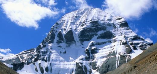
- In Tibetan AR, the PRC can offer a tour to the city of Burang. Over the city on the mountain range was built by the Simbiling Monastery and the Grand Fort Tegla Kar - currently the ruins were left from the fort, the monastery was restored. Under them is a 9-storey destroyed monastery of Religion Bon - TsEGU GOMPA. Through the burang runs the path to sacred Lake Manasarovar and Mount Kaylash.

- In Nepal, it is worth staying in Kathmandu, He is ancient city, preserved many ancient buildings, there are palace complexes, museums and religious temples. About 50 monuments of the history and culture of the country are about 50 monuments of the history and culture of the country, the Khanuman-Dhoka complex is especially interesting.

- Butane. Among the attractions of the country allocated national Library, Created in 1967 to preserve the historical heritage of the people. It is located in a beautiful octagonal building. In addition to books, old letters and historical documentation are stored there. There are other historical buildings around.
A visit to Himalayas tourists
Tourists visit the Himalayas mining system with different goals:
- mountaineering;
- skiing;
- pilgrimage;
- body and spiritual rehabilitation.
Tourists flock here with thousands, every year the flow grows. The most suitable period of May-July and September-October. Summer and winter are rainy and snowy seasons. Himalayas are in the territories of 5 states, so how to get here, get a visa, which fees will be addressed to the journey to find out in advance of your operator, or find information on the Internet.

The scale of the Himalayan vertex system attracts not only tourists, but also scientists. Due to the long political isolation of mountain countries and the inaccessibility of their territories, this region of land has not yet been studied sufficiently by biologists, geographers, geologists, historians.
Although the study is gaining momentum, but there is still an abundance of white spots on all the thematic high elevations.
Article clearance: Svetlana Ovsynikov
Video on the topic: Riddles of the Himalayan Mountains
Himalayas - Most mysterious place on the ground:
Himalayas - a mountain system, considered the highest in the world.
"The best mountains can only be mountains." From school benches, everyone knows that the highest mountains in the world, as well as the most picturesque and mysterious are Himalayas.
The mythical shambal, the mysterious and formidable snowman is only a small part of the myths and legends hidden from us by the eternal white ice of mountain peaks.
Geographical position and characteristics
At the huge area of \u200b\u200bCentral Asia, the highest mountain system on the planet - Himalayas, which translated from Sanskrit means "the abode of the snow". They are located on the territory of the following states:
- Chinese People's Republic (Tibetan district);
- Nepal;
- India;
- Pakistan;
- Bangladesh (small part of it).
The mountain range, stretched in length almost 2400 km, was formed approximately 50-70 million years ago as a result of the movement and clashes of Eurasian and Indo-American tectonic plates. But, despite the ancient years of age, on geological standards, these mountains are still young. The process of growth of Himalayas continues to this day, for example, the highest point of the planet - Jomolungma Mount (Everest) grows about 6 cm per year.

The sharp as the peaks of the mountain peaks of Himalayas rise at the Indo-Ganga Valley and consist of three steps:
Large Himalayas are the highest part of the mountain range, towers above sea level 4 km and above. By the way, in the Himalayas there are 10 of 14 "eight-thousanders" - mountain vertices, the height of which exceeds 8 km, as well as the highest point in the world - Jomolungma Mountain, as the locals of Everest call, according to the names of George Everest, who in the middle of the 19th century Determined the exact height of the vertex. It was as much as 8848 m.
Bully below, at an altitude of 2-4 km above sea, fertile valleys are located, for example, Kathmandu and Kashmir, alternating with mountain chains. These are the so-called small Himalayas. Pregimalaya, the second name is a silicle. These are the youngest and low in the mountain mining system, their height does not exceed 2 km.
The area of \u200b\u200bthe glacial cover, located mainly on the slopes of the high mountains, is 33 thousand square kilometers. The largest glacier is Gangotri (has a length of 26 km), he gives rise to Hangu - the sacred river of the Hindus. Also in the Himalayas, many picturesque alpine lakes, for example, Lake Tilo are located at an altitude of 4919 meters!
Himalayas on the map

River
With the Himalayans originated and carry such the largest rivers of the planet, such as Ind, Gang and Brahmaputra.
Climate
Misss, carrying warm air from the Indian Ocean, most of the year supply the southern slopes of the mountains of the giving moisture. This can not be said about the northern slopes of the Himalayas. Warm southern air is unable to overcome mountain heights, so there is a dry continental climate.
The air temperature in the mountains reaches -40 degrees Celsius in winter, and the wind speed is sometimes as much as 150 km / h. Himalayas occupy the third place on the planet in the number of snow and ice after the Arctic and Antarctic.
Flora and Fauna Gimalay Mountains
Diversity vegetable world Himalayas is in direct proportional dependence on the height. The southern foot of the mountains are the real jungle, which are called "therai" here, and the tropical forests are replaced by a little higher, then mixed, coniferous, and finally alpine meadows.

meadow in Himalayas photo
On the dry and deserted northern slopes of each other, semi-deserts, steppes and mixed forests are replaced. In the Himalayas, very valuable species of trees, for example, Dhak, Salol Tree germinate. The boundaries of the glacial cover are approximately 6 km from the northern side and 4.5 km from the south. Above 4 km, the vegetation of the tundra type is already found - mosses, dwarf shrubs, rhododendrons.
On the territory of Nepal is located national Park "Cigramatha", which is an object cultural heritage UNESCO. Here is the highest peak of the world, all famous mountain Everest, and two eight-year-old peaks, and also live such endemics (rare and disappearing animals and plants), like Irbis (snow leopard), a Tibetan fox, a black Himalayan Bear and others.

himalayan ram photo
From the south, they live and very comfortable rhinos, tigers, leopards feel very comfortable. In the north they live bears, antelopes, yaks, wild horses and mountain goats.
Population
It is worth saying a little about the population of this mountainous region, because it is quite varied. Already 8,000 years before our era, these mountains were settled by tribes. An ancient Aryans lived in the south, in the West - Persian and Turkic peoples, Tibetan tribes in the East. They lived in isolated valleys, where they created their state entities and closed ethnic groups.

In the 19th century, Himalayas were possessions of the British Empire, and in 1947 - the zone of military conflict due to the division of India and Pakistan. The population is still engaged in natural economy. In the southern wet slopes, grain crops are grown, and in more dry and less fertile areas are engaged in distant cattle breeding.
Mastering and interesting facts
Among all eighties, Jomolungma always called special interest. Local tribes for a long time did not rise to her vertices, counting the mountain of the sacred. For the first time Everest was conquered in 1953 by New Zealander Edmund Hillary and Sherpom (Sherpi - the people living in East Nepal) Tenzing Northeum.
The first Soviet expedition took place in 1982. Since 1953, Everest conquered more than 3,700 times, however, there is another, more sad statistics - about 570 people died at a rise. In addition to Everest, the most dangerous "eight thousand" is considered a mountain range Annapurn, the mortality rate among climbers for all time since the first ascent is as much as 41%! True, according to statistics for 1990-2008, Kanchenjanga (8586 meters above sea level) began to be considered the most dangerous vertex, the percentage of mortality over the years is 22%.

flora Himalayev photo
Himalayas every year are becoming more and more "hidden" by the area of \u200b\u200bthe planet. The flow of tourists from the season to the season increases, which will attract the development of infrastructure and the entire tourism system as a whole. Not so long ago, the power of China and Nepal agreed to develop transport message between its countries with the construction of the railway tunnel. It is expected that he will pass under the highest pinnacle of the planet - Everest! There is already a preparatory work on this project.
In 2011, a title lunch took place in the Himalayas at an altitude of 6805 meters! Climbers in the number of seven people rose to a record height, taking a table, chairs, devices and products with them. Lunch still took place, despite the cold and strong wind. Initially, the climbing group wanted to dine at an altitude of 7045 meters, but the hurricane wind did not allow it to do.
general information
The mountain system of Himalayas at the junction of Central and South Asia has more than 2,900 km long and about 350 km in width. The area is about 650 thousand km². The average height of the ridges is about 6 km, the maximum 8848 m - Jomolungma Mountain (Everest). There are 10 eight-thousandths - vertices with a height of more than 8000 m above sea level. In the north-west of the Western chain of Himalayas, there is another highest mountain system - Karakorum.
The population is mainly engaged in agriculture, although the climate allows you to grow only a few types of cereals, potatoes and some other vegetables. Fields are located on inclined terraces.
Name
The name of the mountains occurred from the ancient Indian Sanskrit. Himalaya means "Snow Resident" or "the kingdom of snow".
Geography
The entire mountain range of Himalayas consists of three peculiar steps:
- The first - prefimalai (the local name - the ridge of the shivalik) is the lowest of all, the mountain peaks of which are not raised by more than 2000 meters.
- The second step is the ridges of DhayaDhar, Pier-Pandagger and several others, smaller, is called small Himalayas. The name is quite conditional, since the peaks are already racing on solid heights - up to 4 kilometers.
- They are located a few fertile valleys (Kashmir, Kathmandu and others) who are serving the transition to the most high points Planets - Large Himalayas. Two Great Southeast Asian Rivers - Brahmaputra from the East and Indus from the West, as if covering this majestic mountain array, taking the beginning on its slopes. In addition, Himalayas give life and the sacred Indian River - Gangu.
Records of Himalayev
Himalayas - the place of pilgrimage of the strongest climbers of the world, for which the conquest of their vertices is a cherished life goal. Jomolungma was not submitted immediately - from the beginning of the last century, a lot of attempts were made to climb the "roof of the world." The first one who managed to achieve this goal became in 1953 the New Zealand mountaineer Edmund Hillary, accompanied by a local conductor - Sherpa North Tolding. The first successful Soviet expedition took place in 1982. In total, Everest conquered about 3700 times.
Unfortunately, they put Himalayas and sad records - 572 climbers killed when trying to conquer their eight-chip heights. But the number of brave athletes does not decrease, because the "taking" of all 14 "eight-thousandnants" and receiving the "crown of the Earth" is the cherished dream of each of them. The total number of "crowned" winners today is 30 people, including 3 women.
Minerals
Himalayas are rich in minerals. In the axial crystal zone there is deposits of copper ore, marginal gold, arsenic and chrome ore. In the foothills and interguric basins, oil, combustible gases, brown coal, potash and stone salts are locked.
Climatic conditions
Himalayas - the largest climeturn for Asia. To the north of them, the continental air of moderate latitudes prevails, to the south - tropical air masses. Up to the southern slope of Himalayas penetrates the summer equatorial monsoon. The winds reaches such strength there, which make it difficult to climb the highest peaks, so you can only rise in the spring, in a short period of satisfaction before the beginning of the summer monsoon. On the northern slope throughout the year the winds of the Northern or Western Rumbers are blowing, going with the continent in winter or heavily heated in the summer, but always dry. From the North-West to the south-east of Himalayas, approximately between 35 and 28 ° C.Sh., and in the north-western sector of the mining system, the summer monsoon almost does not penetrate. All this creates large climatic differences within the limits of Himalayas.
The most precipitation falls in the eastern part of the southern slope (from 2000 to 3000 mm). In the West, annual sums do not exceed 1000 mm. Less than 1000 mm falls in the lane in the internal tectonic kitelin and in the inner river valleys. On the northern slope, especially in the valleys, the amount of precipitation decreases sharply. Some of the annual sums are less than 100 mm. Above 1800 m, winter preciputes fall out in the form of snow, and above 4500 m, the snow is throughout the year.
On the southern slopes to a height of 2000 m average temperature January is 6 ... 7 ° C, July 18 ... 19 ° C; To the height of 3000 m, the average temperature of the winter months does not fall below 0 ° C, and only above 4500 m Middle July becomes negative. The snow border in the eastern part of the Himalayas is located at an altitude of 4500 m, in Western, less moisturized, - 5100-5300 m. On the northern slopes, the height of the nival belt is 700-1000 m higher than on the southern one.
Natural waters
A large height and abundant precipitation contribute to the formation of powerful glaciers and a thick river network. Glaciers and snow cover all the high peaks of the Himalayas, but the ends of the glacial languages \u200b\u200bhave a significant absolute height. Most of the Himalayan glaciers belong to the valley type and reaches no more than 5 km in length. But the farther to the east and more precipitation, the topics are longer and lower down on the slopes. On Jomolungma and Kanchenzhang, the most powerful glaciation, the largest Himalayan glaciers are formed. These are dendritic type glaciers with several nutrition areas and one main barrel. The glacier Zem on Kanchenzhang reaches 25 km in length and ends at an altitude of about 4000 m. With jomolungma, the Rongbuque glacier 19 km long, which ends at an altitude of 5000 m. Gangotri Glacier in Kuman Himalayas reaches 26 km; From it begins one of the sources of Ganges.
Especially many rivers flow from the southern slope of the mountains. They begin in the glaciers of large Himalayas and, crossing small Himalayas and the foothill zone, go to the plain. Some large rivers They originate from the northern slope and, heading towards Indo-Ganga's plain, cut through the Himalayas in deep through valleys. This is ind, his influx of Sutland and Brahmaputra (Tsangpo).
Nutrition of the Himalayan rivers rain, glacial and snow, so the main maximum flow rate is summer. In the eastern part in the nutrition, the role of monsoon rains, in the west - snow and ice zones and ice areas. Narrow gorges or canyon-shaped valleys of the Himalayas are replete with waterfalls and spoiled areas. Since May, when the most stormy melting of the snow begins, until October, when the action of the summer monsoon ends, the rivers with rapid flows will be lowered from the mountains, caring the masses of the debris material, which they deposit when leaving the Himalayan foothills. Often, monsoon rains are the cause of strong floods on mountain rivers, during which bridges wash off, roads are destroyed and collaps occur.
In the Himalayas there are many lakes, but among them there are no such that in size and beauty could be compared with alpine. Some lakes, for example, in the Kashmir Basin, are only part of those tectonic depressions that were previously filled with entirely. The Pie Parzaz Ridge is known for numerous glacial lakes formed in the ancient robust funnels or in the river valleys as a result of binding them by Morane.
Vegetation
At a richly moisturous southern slope of Himalayas, high-rise belts from rainforests to high-mountain tundras are exceptionally pronounced. At the same time, for the southern slope, significant differences in the vegetable cover are wet and hot or the dry and cold western part. Along the foot of the mountains from their oriental tip before the flow of the Jamna River, a peculiar wetlands with black or strong soils, called thera, is stretched. For the terrays, the jungle is characterized - thick wood-shrubs thickets, almost impassable due to lian and consisting of soap wood, mimos, bananas, low palm trees, bamboo. Among the terrays there are cleared and drained areas that are used to cultivate various tropical crops.
Above theraev on the wet slopes of the mountains and on the valleys of rivers to a height of 1000-1200 m, evergreen rainforests are growing from high-wheel palm trees, laurels, tree-like ferns and gigan bamboo, with a lot of lian (including palga palga) and epiphytes. In more dry places, less thick forests from the salted tree are dominant, losing the foliage on a dry period, with a rich undergrowth and herbal cover.
At the heights of more than 1000 m to the thermal-loving forms of the rainforest, subtropical species of evergreen and leaf fall trees begin: pines, evergreen oaks, magnolias, maples, chestnuts. At an altitude of 2000 m, subtropical forests replace the forests of a moderate type of leaf fall and coniferous trees, among which only occasionally come across representatives of subtropical flora, for example, magnificently blooming magnolias. The upper border of the forest dominates conifers, including silver fir, larch, juniper. The undergrowths form thick thickets of tree rhododendrons. Many moss and lichens covering the soil and tree trunks. The subalpic belt replacing the forest is highly harvested meadows and thickets of shrubs whose vegetation gradually becomes lower and rarelined when moving to the Alpine belt.
The high-mountain meadow vegetation of Himalayas is extremely rich in species, among them Primulus, anemones, poppies and other bright flowering perennial herbs. The upper border of the Alpine belt in the East reaches a height of about 5000 m, but individual plants are much higher. When climbing jomolungma, the plants were found at an altitude of 6218 m.
In the western part of the southern slope of Himalayas due to less humidity there is no such wealth and diversity of vegetation, Flora is much poorer than in the east. There is absolutely no lapse of the terrays, the lower parts of the mountains are covered with rare-resistant xerophyte forests and shrubs, there are some subtropical Mediterranean species like evergreen oak and gold oil, the coniferous forests of pines and a magnificent Himalayan cedar predominate (CEDRUS DEODARA). Shrub undergrowth in these forests is poorer than in the east, but the meadow alpine vegetation is more diverse.
Landscapes of the northern ridges of Himalayas, facing Tibet, approach the desert mountain landscapes of Central Asia. The change in vegetation with a height is expressed less bright than on the southern slopes. From the bottoms of large river valleys up to snow-covered vertices, rare thickets of dry herbs and xerophytic bushes are distributed. Wood vegetation occurs only in some river valleys in the form of thickets of low-speed poplars.
Animal world
Landscape differences of the Himalayas are reflected on the composition of the wild fauna. Diverse and rich animal world Southern slopes have a pronounced tropical character. In the forests of the lower parts of the slopes and in theractions, many large mammals, reptiles, insects are common. There are still elephants, rhinos, buffaloes, wild boars, antelopes. Jungle literally sissed by various monkeys. Especially characteristic macaques and thin-tales. From predators, the most dangerous for the population of Tigers and Leopards - spotted and black (black panthers). Among the birds are distinguished by the beauty and brightness of peacock plumage, pheasants, parrots, wild chickens.
In the upper belt of the mountains and on the northern slopes of the fauna approaching the composition to Tibetan. A black Himalayan Bear, wild goats and rams, Yaki live there. Especially a lot of rodents.
Population and environmental problems
Most of the population focuses in the middle strip of the southern slope and in intricate tectonic basins. There are many treated lands. On irrigated flat bottoms, the kitrooms sow rice, a tea bush, citrus, grape vines grows on terraced slopes. Alpine pastures are used for grazing sheep, yaks and other livestock.
Due to the high height of passages in the Himalayas, the message between the countries of the northern and southern slopes is significantly complicated. Through some passes are ground roads or caravan trails, highways in the Himalayas are very small. Pass are available only in the summer. In winter, they are littered with snow and completely impassable.
The inaccessibility of the territory played a favorable role in the preservation of the unique mountain landscapes of Himalayas. Despite the significant agricultural development of low-voltage and kitelin, intense grazing of cattle on mountain slopes and an increasing influx of climbers from different countries Peace, Himalayas remain a refuge of valuable plant species and animals. Real "treasures" are included in the list of world cultural and natural Heritage National Parks of India and Nepal - Nan-Dadiev, Sagarmatha and Chitan.
sights
- Kathmandu: Temple complexes of Budanilkantha, Bodnath and Skyambunath, National Museum of Nepal;
- Lhasa: Potal Palace, Barkor Square, Church of Jokhang Monastery Drepung;
- Tchimphu: Buttan Museum of Textiles, Takhimphu-Chorten, Tashicho Dzong;
- Himalaya temple complexes (including Sri Kedarnath Mandir, Yamunotri);
- Buddhist stupas (memorial or reliquary structures);
- Sagarmatha National Park (Everest);
- National Parks Nanda-Devi and Flower Valley.
Spiritual and wellness tourism
Spiritual principles and a cult of a healthy body are so closely intertwined in various directions of Indian philosophical schools, which is not possible any visible section between them. Every year, thousands of tourists come to Indian Himalayas precisely for familiarization with the Vedic sciences, the ancient postulates of yoga teachings, the recovery of their body on the Ayurvedic canons of Panchakarma.
The Pilgrims program necessarily includes a visit to the caves for deep meditation, waterfalls, ancient temples, ablution in Ganges - sacred for the River Hindus. The suffering can conduct conversations with spiritual mentors, to get them facelights and recommendations on spiritual and physical purification. However, this theme is so extensive and versatile, which requires a separate detailed presentation.
The natural grandeur and the high-dimensional atmosphere of Himalayas fascinates human imagination. Anyone who at least once came across the magnificence of these places, will always be obsessed with a dream to return here at least once.
- About five to six centuries ago, people called Sherpi moved to Himalayas. They know how to provide themselves with everything necessary for life in highlands, but, in addition, they are practically monopolists in the profession of conductors. Because really the best; The most knowledgeable and most enduring.
- Among the conquers of Everest there are "originals". On May 25, 2008, the path to the top overcame the most elderly climber in the history of climbing - the native of Nepal Min Bahadur Shirschan, who was 76 years old at that time. There were cases when completely young travelers took part in the expeditions. The last record broke Jordan Romero from California, which made the climbing in May 2010 at the age of thirteen (to him the most young guest Jomolungma was considered a fifteen-year-old Sherpace Tsery.
- The development of tourism does not benefit the nature of the Himalayas: even there is no salvation from the garbage left by people. Moreover, in the future, severe pollution of rivers, originating here, is possible. The main trouble is that it is these rivers that provide millions of people with drinking water.
- Shambala is a mythical country in Tibet, which is narrated by many ancient texts. In its existence, followers of Buddha believe unconditionally. She fascinates the minds of not only lovers of all kinds of secret knowledge, but also serious scientists and philosophers. In reality, Shambhala did not doubt, in particular, the most prominent Russian ethnologist L.N. Gumilev. However, there is still no irrefutable evidence of its existence. Or they are irretrievably lost. The sake of objectivity should be said: many believe that Shambala is not at all in Himalayas. But in the most interesting people to legends, proof was concluded about it that we all really need a faith in the fact that somewhere there is a key to the evolution of mankind who own the strength of light and wise. Even if this key is not a guide, how to become happy, but just an idea. Not open ...
Himalayas in art, literature and cinema
- Kim - Roman written by Joseph Kipling. He tells about a boy who looks at British imperialism with delight, surviving during a big game.
- Shangri La is a fictional country in Himalayas, described in the "Lost Horizon" novel James Hilton.
- Tintin in Tibet is one of the Albums of the Belgian Writer and Illustrator Erge. Journalist Tintin is investigating the crash of an airplane in the Himalayas.
- The film "Vertical Limit" describes events taking place on the Choir Mountain.
- Several levels in TOMB RAIDER II and one level in Tomb Raider: Legend are in the Himalayas.
- The film "Black Narcissus" tells about the Order of the nuns, founded the monastery in Himalayas.
- The kingdom of Golden Dragons - Roman Isabel Allenda. Most of the events occur in the forbidden kingdom - a fictional state in Himalayas.
- Drachenreiter is the book of the German writer Cornelia Funkey, telling about Brown and Dragon, traveling to the "Edge of Paradise" - a place in the Himalayas where the dragons live.
- Expedition Everest is a thematic ride in the World Walt Disney Rest Center.
- Seven years in Tibet - a film, filmed based on the eponymous autobiographical book of Henry Harrera, describing the history of the adventures of the Austrian climber in Tibet during the Second World War.
- G.I. Joe: The Movie is an animated film telling the history of Cobra-Li civilization that escaped in the Himalayas after the glacial period.
- Far Cry 4 - first-face shooter The plot that tells about the fictional region of Himalayas, where the self-proclaimed king is dominated.
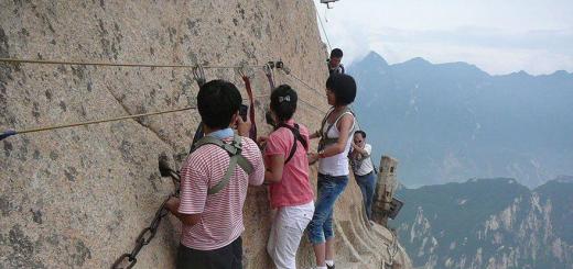
Himalayas are replete with a huge number of rocky, almost vertical slopes for which it is very difficult to get climbing, you have to use all sorts of technical devices in the form of crowning hooks, ropes, special stairs and other climbing equipment. Often, rocky ledges alternate deep cracks, and there is so much snow on the slopes of the mountains, that he over time is compressed and turns into glaciers, covering these cracks, which makes the passage of these places deadly. There are no rare cases of convergence of snow and ice, which, rushing down, turn into huge avalanches that demolish everything in their path and can crush climbers in seconds.
The air temperature in the Himalayas, during the rise to the height decreases for every 1000 meters by about 6 degrees. So if at the foot of the summer, the temperature is +25, then at an altitude of 5000 meters it will be about -5.
At the height, the movements of the air masses are usually strengthened, often turning into a hurricane wind, which makes it difficult to move, and sometimes it makes it impossible, especially on narrow ridges of the mountain ranges.
Starting from a height of 5000 meters, the atmosphere contains approximately half of the oxygen at sea level, to which the human body is accustomed. The lack of oxygen is destructive on the human body, dramatically reduces its physical capabilities and leads to the development of the so-called mountainous disease - shortness of breath, dizziness, chills and interruptions in the work of the heart. Therefore, usually at this height, the human body needs time to acclimatize.
.jpg)
At the height of 6000 meters atmosphere is so discharged and poor oxygen that complete acclimatization is no longer possible. No matter what physical exertion is a person, he begins to slow down. The rise at a height of 7,000 meters for many is already deadly dangerous, the consciousness begins to be confused at such a height and even thinking it becomes difficult. The height of 8000 meters is called the "Death Zone". Here, even the strongest climbers can survive at best for just a few days. Therefore, all high-rise ascents are carried out using respiratory oxygen apparatus.
.jpg)
But here are representatives of the Nepalese Sherpi tribe that are constantly living in the Himalayas, at the height feel quite comfortable and therefore, as soon as the Europeans began to "master" the mountain peaks of Himalayas, the men of this tribe began to work in expeditions by conductors and porters, receiving a fee for this. Over time, it became their main profession. By the way, Sherp Tencing Norki Parabe with Edmund Hillary was the first to rise to the top of Himalayas - Everest, the highest mountain in the world.
But all, these sometimes deadly, dangers did not stop the enthusiasts of the mountaineering. It took not one decade that all these vertices would be conquered. Here is a brief horology of ascent on the highest mountains of our planet.
1950, June 3 - Annapurn
French climbers Maurice Erzog, Louis Lashenal rose to Annapurn's peak, which is 8091 meters. Anapure is considered the seventh of the highest mountains in the world. Located in Nepal, in the Himalayas to the east of the Gandaka River flowing through the deepest gorge in the world. The gorge shares Annapurnu and another eight-thousand meter of Dhaulaagi.

Climbing anampur is considered one of the most complex climbing in the world. With that, this is the only conquest of the eight-thousandths that was committed from the first time, and besides without oxygen apparatus. However, their feat was given high price. Since they were shods only in leather boots, Erzog froze all the fingers on the legs and because of the gangrene began, the doctor of the expedition was forced to be amputate them. For all the time, only 191 people successfully rose on Annapurna, it was less than any other eighties. The climbing on Annapurna is considered the most dangerous, with a mortality of 32 percent, like any other eight-year-old.
1953, May 29 - Everest "Jomolungma"
Participants in the English expedition of New Zelandets Edmund Hillary and Nekheva Nagyi Tenzing were the first to conquer Everest - a top of 8848 m. In Tibetan, this mountain is called Jomolungma, which means "Goddess Mother of Snow." Nepalese her name "Sagarmatha", that is, the "mother of the Universe". This is the highest mountain in the world. At the border of Nepal and China.
Everest is a triangular pyramid with three sides and with ridges that extend to the northeast, southeast and northwest. Southeast ridge more canvas and is the most widely used route for climbing. It is this route to the top through the Khumba glacier, the valley of silence, from the foot of Lhotz through the southern saddle, won their first ascent of Hillary and tension. And for the first time to commit an ascent to Everest tried by the British back in 1921. They then could not go from the south side, due to the ban of the Nepalese authorities and tried to rise from the north, from Tibet. To do this, they had to go the whole mountain massif Jomolungma, having passed more than 400 kilometers to get to the top of China. But the time for bypass was lost and the beginning of the monso did not make it possible to climb. After them, the second attempt on the same route was made by the British climbers George Lee Mallory and Andrew Irwin, who, too, was unsuccessful, who ended with the death of both at an altitude of 8,500 meters.

Despite their reputation extremely dangerous MountainThe commercial foundation for Everest, over the past few decades has made it very popular entertainment for tourists. According to the latest data, 5656 successful entries were made to Everest, at the same time 223 people died. Mortality amounted to about 4 percent.
1953, July 3 - Nangarbat
Peak located in the north of Pakistan in the western part of the Himalayas. This is the ninth height of the eight-thousandth, 8126 meters. This peak has such steep slopes that even snow does not hold on its top. In the language of Urdu Nangarbarbat means "Naked Mountain". The first on the peak rose Austrian climber Herman Boulev Member of the German Austrian Himalayan Expedition. Climbing committed alone, without an oxygen apparatus. The climbing time to the vertices was 17 hours, and with a descent of 41 hours. It was the first successful climbing for 20 years of attempts, before which 31 waters were already died there.

According to the latest data, 335 successful ascents were committed in total on Nangarbat. 68 climbing participants died. Mortality is about 20 percent, which makes it the third in danger of the eight thousand.
1954, July 31 - Choir, "K2", "Dapsang"
The first to the top of the K2, the second at the top of the top of the world, the Italian climbers were climbing Laconelli and Akille Companions. Although attempts to conquer K2 began in 1902.

Peak Choir or Other Dapsang - 8611 meters high, is located on the Baltoro Muztag Ridge in the Karakorum Mountainside, on the border of Pakistan and China. The unusual name K2, this mountain received in the 19th century, when the British expedition was measured by the height of the peaks of Himalayas and Karakorum. Each newly measured peak was given a sequence number. K2 was the second mountain, on which they stumbled upon and since then it was allowed for her name for a long time. Local residents calls this lamp Phar, which means " High mountain" Despite the fact that the K2 is lower than Everest, it turned out more difficult to climb it. For all the time on K2 there were only 306 successful ascents. When attempts to climb, 81 people died. Mortality is about 29 percent. K2 are not rarely called the migrant
1954, October 19 - Cho-Oyu
The first on the peak rose members of the Austrian Expedition: Herbert Tihi, Joseph Yohler and Sherp Pazan Dava Lama. The top of Cho-Oyu is located in the Himalayas, on the border of China and Nepal, in the Mahalangur Himal mountain range, Jomolungma mountain range, approximately 20 km west of Everest Mountain.

Cho-ohu, on Tibetan means "goddess turquoise." He has a height of 8201 meters, it is the sixth height of the eight-thousandth. A few kilometers to the west of Cho-Oyu is the $ 5716 m. This pass pass from Nepal to Tibet laid by sherpami as the only trading pathway. Because of this, the pass, many climbers consider cho, the easiest eight-year-old. This is partly true, because all the ascents are committed from Tibet. But from the side of Nepal, the South Wall is so complicated that it was possible to conquer units.
In total, 3138 people safely rose safely, this is more than any other peak besides Everest. Mortality is 1%, less than any other. It is considered the safest eight-thousandth.
1955, May 15 - Macal
For the first time, the French Jean Kuzi and Lionel Terre rose to the top of Makalu. The climbing on Makal was the only one in the history of the conquest of eight-thousandnes, when the vertices reached all nine participants of the expedition and including the Senior Sherry Explorer groups. This happened not because Makalu is such a light mountain, but because it turned out to be extremely successful weather and nothing prevented the climbers to achieve this triumph.
Macanal 8485 meters high, the fifth mountain in the world in the world, is located just 20 kilometers southeast of Everest. In Tibetan, Makali means "big black". Such an unusual name is given to this mountain. Because the slopes of her very cool and the snow is simply not held on them, so it remains bare most of the year.

Winning Makalu turned out to be quite difficult. In 1954, it tried to make the American team led by Edmund Hillary, the first person rising to Everest, but they could not succeed. And only the French after a large preparatory work and the coordinated work of the team managed to implement it. In total, for all time on Makal, 361 people successfully rose, while 31 people were killed when attempting to climb. Muski mortality in macales about 9 percent.
1955, May 25 - Kanchenjang
The first successfully climbed the British climbers George Band and Joe Brown. Before climbing, local residents warned climbers that the Sikkimsky God lives on the top of this mountain and it is impossible to disturb it. They refused to accompany the expedition and the British went to ascent independently. But then, due to superstition, then for what reason, rising to the top, they did not reach a few feet to the top, calculating that the vertex is conquered.

Kanchenzhanga is located on the border of Nepal and India, about 120 kilometers south of Everest. The name "Kanchenjang" translated from Tibetan means "Treasury of five great snows". Until 1852, Kanchenzhanga was considered the most high mountain in the world. But after Everest was measured and the other eighties, it turned out that it was the third top height in the world, its height is 8586 meters.
Another legend is in Nepal says that Kanchenzhanga is a mountain-woman. And women should not go to her under the fear of death. Of course climbers people are not superstitious, but nevertheless only one woman climbing British Jenet Harrison rose on her top for all the time. All would anything, but after a year and a half, Jenet Harrison died during the ascent on Dhaulagiri. For all the time, 283 mountaineers successfully rose on Kanchenjang. From those attempted to rise 40 people died. The mortality rate of about 15 percent.
1956, May 9 - Manasl
The mountain is 8163 meters high, the eighth graffitiic height. Attempts to rise to this peak were several. The first time in 1952, when the Swiss and French teams entered the championship of conquering Everest, the Japanese decided to conquer for the start in Nepal about 35 kilometers east of Annapurna Peak Manasl. They grew all the approaches and outlined the route. For the next 1953, they began to climb. But the fleeing Purga broke all their plans and they were forced to retreat.

When in 1954 returned, the local Nepalese fell against them, referring to the fact that the Japanese were defiled by the gods and caused their anger, because after the departure of the previous expedition, their village suffered misfortune: there was an epidemic, cropped, the temple was destroyed and three priests were killed. Armed with sticks and stones, they drove the Japanese from the mountain. To settle the deal with local residentsIn 1955, a special delegation arrived from Japan. And only next 1956, paying 7,000 rupees to compensate for damages and 4,000 rupees for the construction of a new temple and arranged a large holiday for the population of the village, the Japanese received permission to climb. Thanks to the wonderful weather, the Japanese climber Tosio Imanisi and Sirdar Sherp Gyalzen Narbu on May 9 rose to peak. Manaslo remains one of the most dangerous eight-thousanders. There were only 661 successful climbing on Manasl, sixty-five climbers died when climbing. Lamining mortality is about 10 percent.
1956, May 18 - Lhotse
Fritz Luhsinger and Ernst Rice The members of the Swiss team became the first people who managed to climb to the top of Lhotzz 8516 meters high, the fourth highest top of the world.

Peak Lhotse is located on the border of Nepal and China a few kilometers of south of Everest. These two peaks are associated with a vertical ridge, the so-called southern saddle, the height of which is all over 8000 meters above 8000 meters. Usually, the ascent is carried out on a western, more common slope. But in 1990, the Soviet Union team rose on the south side, previously considered at all available, as it represents a 3300-meter almost vertical wall. A total of 461 successful climb was performed on Lhotse. For all the time there were 13 climbers, mortality is about 3 percent.
1956 July 8 - Gasherbrum II
Top of 8034 meters high, thirteenth in the height of the mountain in the world. For the first time on Gasherbruum II, Austrian climbers Fritz Murez, Joseph Larh and Hans Villenpart rose. They rose to the top on the south side along the southwestern ridge. Before climbing the peak itself, rising 7500 meters to the height, they staged a temporary camp for overnight stays, and then early in the morning they went to the assault. It was a completely new one who did not have a tested approach to rock climbing, which later began to apply climbers from many countries.
.jpg)
Gasherbruum II is the second of the four peaks of Gasherbrum in Karakorum on the border of Pakistan and China at about 10 kilometers southeast of K2. The Baltoro Music Ridge in which Gasherbrum II is known for the longest Caracorum Glacier, longer than 62 kilometers. This served as a reason for the fact that many climbers descended almost from the very top of Gasherbruum II on skis, on snowboarding and even with a parachute. Gasherbruum II is considered one of the safest and easiest eighties. On Gasherbruum II, 930 climbers were successfully risen and only 21 people died at unsuccessful attempts ascent. The mortality of the climb of about 2 percent.
1957, June 9 - Broad Peak
Mountain 8051 meters high, twelfth in height of the elevation. The first time they tried to climb the Germans in 1954 on BROUD peak, but because of the low temperature and the storm wind, their efforts were not crowned with success. The first to rose to the peak Austrian climbers Fritz Wintershteller, Marcus Schmuk them Kurt Dimberger. The climb was carried out on the southwest side. The expedition did not use porters and all property raised the participants themselves, which was quite greater complexity.

Broad Peak or Dzhanaging is located on the border between China and Pakistan, a few kilometers southeast of K2. This area is still less studied and geographers hope that over time he can get sufficient popularity. For all time on BROUD peak there were 404 successful ascents. They turned out to be unsuccessful for 21 climbers who died when attempting to climb. The mortality rate of about 5 percent.
1958, July 5 - Gasherbruum I "Hidden Peak"
Mountain 8080 meters high. Top belongs mountain massif Hasherbruum - Caucarum. Purchases rise to Hidden Peak began a long time ago. In 1934, the international expedition participants were able to rise only to a height of 6,300 meters. In 1936, French climbers defeated the frontier 6900 meters. And only two years later, the Americans Andrew Kaufman and Pete Schöng rise to the top of Hidden Peak.

Gasherbruum I or Hidden Peak, the eleventh in height of the eight-thousandth of the world, one of the seven peaks of the massif Gasherbrum is located in Kashmir in Pakistan under control of the North Area on the border with China. Gasherbroum from the local language is translated as "polished wall", and it fully corresponds to this name. Because of his steep, almost polished, rocky slopes, the climbing on him was rejected by many. In total, 334 people successfully rose at the peak, while 29 climbers were killed while trying to climb. Lamining mortality is about 9 percent.
1960, May 13 - Dhaulaagiri I
"White Mountain" - heights of 8167 meters, seventh height from eight-thousandnesses. The first to the top participants of the European team: Dimberger, Shembert, Deriner, Forier and Sherpes Navang were held. For the first time, an airplane was used to deliver members of the expedition and equipment. On the "White Mountain", the French, participants of the 1950 expedition, were noted in 1950. But then it seemed to them not affordable and they switched to Annapurna.

Dhaulaagiri I is located in Nepal, 13 kilometers from Annapurna and climb to her vertex in 1954, Argentines. But due to the strong Purgi, only 170 meters did not reach the top. Although by the standards of Himalayas, Dhaulaagiri of all the sixth height, it is a strong nutpiece. So in 1969, the Americans left the seven of their comrades in the southeastern ridge at the southeastern ridge. In total, 448 people successfully rose to the top of Dhaulaagiri, but 69 climbers in unsuccessful attempts were killed. Landsumbage mortality is about 16 percent.
1964, May 2 - Shishabangm
Top with a height of 8027 meters. The first to conquer Shishabangum eight Chinese climbers: JJ Jing, Zhang Zhunian, Van Fuzhou, Zhen San, Zheng Tianlaan, Zunju, Snoms Daughters, Migmar Trash, daughters, Nynten. For a long time, climbing this peak was prohibited by the Chinese authorities. And only after the Chinese themselves rose to his top, it was possible to participate in the ascent and foreign climbers.

Schishabang Mountain Mountain, Geosenzhanfeng, on Indian State Indian, is located in China in the Tibetan autonomous area a few kilometers from the Nepalese border. It consists of three vertices, two of which are above 8 kilometers. Shishabangm Main 8027 meters and Shishabangm Central 8008 meters. In the program "All 14 eighties in the world", there is a rise to the main peak. In total, Shishabang was 302 successful ascents. Twenty-five people died, trying to climb to the top. Lifensive mortality of about 8 percent.
As can be seen from the chronology of ascent on the highest peaks of the Himalayas, for more than 40 years left for their conquest. With that, on the analysis of the Himalayan Institute of Mountaineering, the most dangerous of all are considered: Annapurna, K2, and Nanga Parbat. At the ascents of these three peaks, Himalayas took the life of every fourth, which misfortunely misinterpreted.
And yet, despite all these fatal dangers, there are people who conquered all the eighties. The first of them was Reinhard Messen Italian climber, German by nationality from South Tyrol. And although in the first ascent on Nanga-Parbat in 1970, his native brother Gunter died, and he himself lost seven fingers on his feet; In the second climbing on Manaslo in 1972, his partner died in a bundle, it did not stop him. Starting from 1970 to 1986, he rose one after another to all 14 of the highest peaks. With the Everest, he climbed twice, in 1978, together with Peter Habelter on a classic route through the southern saddle, and in 1980 alone northern route, Moreover, during the monsoon season. Both climbing without the use of oxygen devices.
In total, now there are already 32 people in the world who conquered all 14 eighties and this is probably not the last people of whom are expected by Himalayas.
Himalayas - This is the highest mountain system of our planet, which stretched in Central and South Asia and is located on the territory of such states as China, India, Bhutan, Pakistan and Nepal. In this mountain range there are 109 vertices, their height average reaches more than 7 thousand meters above sea level. However, one of them exceeds them all. So, it will be about the highest peak of the Himalayas mountain system.
What is she, the highest peak of Himalayas?
The highest peak of Himalayas is the Jomolungma Mountain, or Everest. It towers in the northern part of the Mahalangur Himal Range, the highest mountain range of our planet, where you can get only after arriving at. Its height reaches 8848 m.
Jomolungma - This is the name of the mountain in Tibetan, which means "Divine Mother of the Earth". At Nepali language, the top sounds like Sagarmatha, which is translated by the "Mother of God". Everest was called it in honor of George Everest, the British scientist, who was led to the surrounding territories by the geodesic service.
The form of the highest peak of Himalayas Jomolungma is a three-headed pyramid, which has a south slope sharper. As a result, the part of the mountain is practically not covered with snow.
Conquest the highest top of the Himalayas
Invertible jomolungum has long attracted the attention of land climbers. However, unfortunately, due to adverse conditions, mortality here is still high - official reports of death on the mountain was more than 200. At the same time, almost 3,000 people successfully rose and descended from Everest. The first ascent to the top occurred in 1953 by the Nepalets Tenzing Northeem and New Zealander Edmund Hillary with oxygen appliances.