Pont Evksinsky - Sea Scythian
For world history, Crimea has become known for many centuries to our era. In the most ancient times, the peninsula was called Tarakik. This name recorded the Byzantine historian of the VI century of our era of the proofing of the NZ Caesarea. The Old Russian chronicle "Tale of Bygone Years" leads a somewhat modified form of this name - Tavria. Only in the XII century, the Tatars who conquered the peninsula, called the Crimea greek city Solhat (now the Old Crimea), which has become the center of their possessions. Gradually, throughout the XIV-XV centuries, this name has spread to the entire peninsula. The names of the Greek colonies arising in the Crimea in the VI century BC It is impossible to be considered the oldest Crimean toponyms. Before the arrival of the Greeks in Crimea, numerous tribes lived here, who left the trail in history, archeology, and toponymics.
Crimea belongs to those few places on Earth, where people have appeared from time immemorial. Here, the archaeologists were opened by their parking lot of the Paleolithic - early Stone Age.
Scientists believe that before the beginning of the discrepancies of peoples - about 3700 BC. On the entire territory of the Caspian steppes of Eastern Europe and Western Asia, a single language of communication was, the roots of which lie in.
Roots of the most ancient names crimean, rivers, mountains, lakes should be sought in the Proto Indo-European language - Vedic Sanskrit: Support, stronghold, tower, tower, pylon. (related word in other Russian lang kr "and" KRTA "- create, build, do, that is - This is a man-made structure - the fortress, the Kremlin.
Historian-Slavist, archaeologist, ethnographer and linguist, author of 11-languid encyclopedia "Slavic antiquities" Lubeza Hidelle claimed that "... Among the Scythians mentioned by the Herodot, not only the neury ... but also scythians are referred to as pahars and farmers ... were undoubtedly Slavs, who experienced the influence of Greco-Scythian culture. "

The first known from the ancient Greek sources of the population of Crimea was Scythians, Tavra And the Kimmerians who were relative or Thracian.

In the southwestern part of the Crimean Peninsula, 15 km from Sevastopol, there is an ancient city Balaclava having a rich history, numbering more than 2500 years.
From ancient times, it was a powerful military fortress created by nature itself. Balaclava harbor is closed with high cliffs from all sides of the sea storms, and a narrow entrance to the harbor reliably protects it from the enemy invasions from the sea. Reports that in the mountains of Tavrida, there were brands who know a lot in military art.

Within the Dnieper Levobasya there are two toponyms an ancient Slavic species - Perepop, Szrenevsky - Rocking, Possible tank of reference Indo-Aryan * KRTA - "Made (i.e. - manually dug)" , Hence the name of the Crimea. In about the same place, the founding of the Crimean Peninsula has other Russians. Oleshye , one of the "populated places" by the sea, which from time immemorial - from Herodotovskaya Gileses ('Y - "Forest") to the current Aleshkovsky (!) Sands - Stalling conveyed and retained the image of this "wooded" Piglet among those surrounding unplaced spaces.
The name "Balaclava" comes from the word, power, power, energy, power, military force, army, army. " The word "BALA" occurs from RV). Perhaps the name of the Harbor "Bala + Klava" - comes from the "Bala" - military, "Klap, Calpat" - Klṛ p, Kalpate - "Fasten, strengthen, fortress" (from the root "Kḷ P"), that is - Military fortress.
Ancient Greek Geographer and Historian Strabo (64 BC. E. - 24 N. E.) and Roman writer, author of the "natural history" of Pliny Senior (23-79. N. E.) Tied the name of the harbor and military fortress named Son (II century BC.) Palak - "Strong warrior." The names of the war of war in ancient Greece - Pallas. (Pallas), the epithet of the goddess Athena Palada (Dr.Grech. παλλὰς ἀθηνᾶ) – militant goddess military Strategies and wisdom, and the name of Scythian Tsarevich Palac - "Warrior", come from one root.

In the V century, a powerful, residents of which consisted of representatives of various peoples - Greeks-Colonists, Scythians arise on both shores of the Kerch Strait. Dynasty dominant Spartakida was Thracian origin, the Tsarist Guard was also the same. In Proto-Indo-European language, the roots of the Scythians, Kimmerites, Greeks are ready, is why they found a common language and, allowing the interpenetration of cultures and linguistic borrowings on the peninsula, for example, the German tribes - Scythians, which were in the Unified Gothic Tribal Union in Crimea .
The role is ready in the life of the Crimea, it was very significant, because even in the Byzantine medieval sources of Crimea called Gothia. Belongs to the Indo-European group of languages. The few fortified Outcasting settlements remained in the Black Sea region in the western mountainous part of the Crimea, populated by the Greeks and Subordinate Byzantium, as well as from the V century in the Azov Taman Peninsula Outputs at the end of the IV century turned out to be cut off the invasion of Huns and other nomads in the Black Sea region. Byzantine Emperor Justinian I Built in the Crimea to protect the settlements of the sharp (oriental ready) line of fortifications. In Tavrida (Crimea) was Gothic Mongup City Fortress, Doros (Doros), Feodoro, Ready-Trapezite traders living on "Dining Mountain" (near Alushta).

In the 6th century, Crimean goths accepted Orthodox Christianity and patronage from Byzantium. In Crimea, the Crimean-Gothic language, ascending to the Osthots dialect, remained in Crimea the tribes of the Eastern are ready to come in the Black Sea and in the Azov region in 150-235, and living in the neighborhood with Greek immigrants and Scythians. Flemish monk V. Rubruk, who testifies in 1253, that goths in the Crimea At this time, they spoke "German Naschai" ( iDIOMA TEUTONICUM - "TAUTURIC LANGUAGE").
Distribution of power kiev princes of ancient Russia At quite most of the peninsula, the population of the Crimea with ancient Russian state brought closely and for a long time. There were a kind of gate through which Kievan Rus Communication with the countries of the East came out. In the first century, our era appeared in Crimea slavs. Their resettlement on the peninsula naturally explain to the so-called great relocation of peoples in the II-VII centuries.
On the Slavs in Tavria, the Byzantine sources are remembered from time to time. But a more complete idea of \u200b\u200btheir lives on the peninsula, scientists were able to receive, just starting with the era of Kiev Rus. Archaeologists have discovered the remains of material culture in the Crimea, the foundations of architectural structures close to those built in the cities of Kievan Rus. Moreover, the frescoes and the plaster of the Crimean Russian churches in their composition very much resembles the frescoes of Kiev Cathedrals of the XI-XII centuries.
Much of the Old Russian population of Crimea becomes famous from writing sources. Of "Lives of Stephen Surozhsky" learn that at the beginning IX century Russian Prince Braclin convinced the Crimean cities of Corsun (or Kherson,so in the Middle Ages began to be called Chersonese) and Sudak. And in the middle of the same century, the ancient rhuses for a long time ardent in the Azov region, mastering the Byzantine city Tamarha Later Tmutarakanyu, the capital of the future of the Old Russian principality Tmutarakan, part of the lands of which extended to the Crimea. Gradually Russian principality spreads its own the power of the north-western part of it to the Gerson's Occolic, the entire Kerch peninsula.

Tmutarakanaca Prince forest in the middle of the X century. Remote from other Russian lands, it was under constant pressure of Byzantium, but managed to preserve. Successful hike Vladimir Svyatoslavich on Kherson in 989 expanded the ancient Russian possessions in the Crimea. In the Russian-Byzantine Agreement, Kievan Rus was able to join the city of Bospyrus with the Ocean, who received the Russian name Kortchev (from the word "Corca" - the forge, the current Kerch).
On the Taman Peninsula, a Tmutarakan stone was found, on which the inscription was carved that 1068 year Russian Prince Gleb Svyatoslavovich "Meril Sea on ice from Tmutarakan to Korchev. 10,000 sohen and 4000 soot. "
Arabic geographer Idrisi called Kerch Strait "The mouth of the Russian River". There he was even known to the city with the name "Russia". Medieval European and Eastern geographic Maps Crimea recorded a lot of toponyms, titles of cities and settlements, indicating the long and long stay of Russov in the Crimea: " Cosal Di Rosia, "Rossia", "Rosmozofar", "Rosso", "Rossika" (last near Evpatoria) and others.
At the end of the XII century, Navalo-Polovtsev's nomads, who took out the steppes of the Northern Black Sea region, cut off the Crimea from Kievan Rus for a long time. At the same time, Polovtsy destroyed the Tshutarakan princess, to a significant part of the Russian population kept on the peninsula. One NZ of his support points has become city of Sudak (Russian title Surozh). According to reports of the Arabic writer Ibn al-Asira. In the late XII - early XIII centuries, many Russian merchants lived in the Crimea and the Black Sea was called Russian sea.
The Russian population of the peninsula, as well as representatives of other local peoples, caused an irreparable blow to the conquest of the peninsula mongol-Tatars after 1223.
Antique cities of Crimea
In ancient times, sea routes tied the coast of the Black Sea with the Mediterranean, where at the end of the II - early I millennium BC. There was a great civilization of Greece. From the shores of Eldlas, brave sailors went to search for new lands.
Where are the largest now seaports, Industrial and resort centers of Crimea - Evpatoria, Sevastopol, Feodosia and Kerch, in the VI-V centuries. BC. The ancient Greeks founded the city of Kerkinitid, Chersonese, Feodosius, Panticapey, and near them - Mirmekiy, Thiritaka, Nymphi, Kimmerik and others. Each of them was the center of the agricultural district where the wheat was grown, grapes were cultivated, livestock. The cities were located temples, public and administrative buildings, markets, artisans workshops.
Comfortable geographical position contributed to the development of trade. The merchants were exported to slaves and agricultural products in the Mediterranean, purchased from local tribes - Scythians, Mets, Sindov. In exchange from the cities of the Balkan Peninsula and Malaya Asia, olive oil, wine, art objects and crafts were brought.
Chersonese was founded in 421 BC. On the shore of the bay, which is now called quarantine. Later, the city has significantly expanded possessions. During his heyday, Kerkinitid was obeyed, a wonderful harbor (on the site of the modern village of Chernomorsky) and other settlements of the North-West Crimea.
The Chersonese state was a slave-owned democratic republic. The supreme authority was the People's Assembly and the Council, which solved all the issues of foreign and domestic politics. The leadership role in the management belonged to the largest slave owners whose names were reported by Chersoness inscriptions and coins.
Archaeological excavations started back in 1827 showed that the city was well fortified. The remains of defensive structures are massive towers, fortresses, parts of stone walls - preserved throughout the state. This indicates the permanent military danger, which residents were subjected. The famous Chersoness oath tells about their patriotism. Chersonesers swore that they would not betray enemies, nor his possessions will guard democratic system, not divided by state secrets.
As the archaeological studies confirmed, the city had the right layout. Residential buildings were united in blocks, the streets crossed at right angles. They were brought by small stone. Along the streets passed stone drains. Temples rose on the squares. Public buildings and houses of rich citizens decorated with colonnades and mosaic floors.
From the ancient buildings to this day only the founding of the walls and basement rooms have reached. The mint, baths, theater ruins that existed from the III century are especially interesting. BC. According to IV. AD Only staircases and stone benches for viewers are partially preserved from it. Judging by their size, the theater accounted for up to 3 thousand spectators.
Craftsmen were located near the urban walls. There archaeologists have discovered the remains of ceramic production: furnaces for firing clay dishes, stamps for ornaments, forms for the manufacture of terracotta reliefs. They flourished in Chersonese and other crafts - metalworking, jewelry, weaving.
The largest antique state of the Black Sea region was the Bosporian kingdom. It was formed as a result of the unification of the initially independent Greek cities, such as Panticapy, Mirmekiy, Tyritaka, Fanagoria and others, located along the shores of the Bospop of the Kimmerian - modern Kerch Strait. The capital of the state became a panticapy. From 438 BC. More than three hundred years of the rules of the dynasty of Spartokidov.
At the end of the V - early IV centuries. BC. Niffees and Feodosia, as well as land inhabited by other tribes, were attached to the possessions of Bospor. In i century BC. Bosporus captured most of the territory of Crimea, submitted to himself Chersonesos.
Excavations on Mount Mitridat, conducted in Kerch from the end of the XIX century, allowed to restore the size and plan of the Pantikapey. At the top was Acropolis - central fortification of the city with powerful defensive walls and towers. Inside him was the most important temples and public buildings. Down on the slopes terraces descended quarters from single or two-storey stone buildings. The whole city and its surroundings were obscured by numerous strengthening lines. A deep and comfortable harbor reliably covered trade and military vessels.
Found fragments of marble statues, pieces of painted plaster and architectural details allow us to talk about the rich decoration of the squares and buildings of the city, about the skill of the ancient architects and builders.
On the site of Mirmekia and Tyritaki, not far from Kerch, except urban walls, residential buildings and sanctoes, archaeologists opened several wineillers and baths for salting fish. In nymphay, near the modern village of heroevka, - Temples Demeters, Aphrodites and cabins; In Ilurate, near the modern village of Ivanovka, - the Bosporus military settlement of the first centuries AD, guarding the approaches to the capital.
Next to each antique city was his necropolis - city of dead. Usually buried in simple earth graves, sometimes laid out with tiled or stone plates. Rich and notable placed in wooden or stone sarcophages. For their burial, the scleps were built isolated from stones or chopped in rocks. Walls of crypts and sarcophagus decorated with painting, reliefs, inlay. Ornaments were applied on them, depicted mythological scenes, scenes real life. Together with the dead, put things belonging to him: decorations, dishes, weapons, vessels with incense, terracotta figurines and other items. In one of the Panticaipei burials III century. N.E., perhaps, the Bosporian Tsar of the risk was found a unique gold mask, reproducing the features of the deceased face.
Researchers have long been interested in large mounds located in the vicinity of Kerch. They discovered the burials of the Bosporian kings and nobility with outstanding works of Greek art: gold and silver ornaments, bronze and glass products, painted and curly vases.
Goldist temporal suspensions IV c are considered to be a masterpiece of world art. BC. From Kurgan Kul-both. They are made in the form of disks to which numerous woven intersecting chains connected by plates and sockets are attached. On the disk with a diameter of 7 cm - the face of Athens's head in the helmet with well-distinguisible figures of griffins, owls and snakes. The finest filigree plates, sockets, as well as the circle of the disk are covered with grain and blue enamel.
The most valuable finds from the excavation of the ancient cities of Crimea are presented in the collections of the State Hermitage in St. Petersburg, the State Historical Museum and the State Museum of Fine Arts. A.S. Pushkin in Moscow, as well as others.
Now on the territory of Chersonese in Sevastopol and on Mount Mridat in Kerch organized reserves. Every year, thousands of people come there to pass through the streets and squares of the ancient cities, to meet the greatest monuments Culture.
When on South Bank The Romans were established, they created a fortified items on the coast to protect Chersonese. From Roman fortifications, the biggest character was at the Cape Ai-Todore (now there is a lighthouse next to the "swallow nest"). Strengthening chas (in Greek "Pillars", "Count", that is, "fenced place") was founded in the 70s. I in. With the Roman Emperor Vespasiana. At the end of the century, there was a garrison, in II century. Soldiers of the I Italy Legion were placed. The last Roman garrison of the Fort was the warriors of the XI Claudiyev Legion (End II - the first half of the III century.). About these three periods of character history, stamps on bricks and tile are evidenced.
N.I. Shaiko
Photo beautiful places Crimea


sights
32248
how tourist centre Crimea is known from the second half of the XIX century. The special popularity of the peninsula among the imperial and highest foreign guests is evidenced by a large number of summer residences - palaces and villas, which to this day make up the architectural appearance of the Crimean cities. Time passes, and the Crimea becomes not just a privileged holiday destination, and a healthy-sustainable scale. However, retaining the mass, and this tradition has undergone transformation. Wild rest Winned over organized sanatorium treatment.
Today, the Crimea is perceived by many as the focus of sea resorts, popularizing beach and outdoor activities. At the same time, the rich and deep history of the peninsula, the traces of which are stored numerous monuments covering the widest temporal and thematic range. Seven many-sided cities presented in our review can fairly be called museums who acquainted their guests with the heritage of the ancient, multinational and generous land called Crimea.
Museum, landmark, Historical monument
The city-hero, one of the three cities of the federal value of Russia, the largest population of the city of Crimea, one of the key naval objects of the country, a major non-freezing marine trading port is all the definitions of the legendary Sevastopol. Of particular importance, the city has acquired since its foundation, when in 1783 he became the main base of the newly formed fleet of the Russian Empire - the Black Sea Fleet. Sevastopol Valiantly surrender two defenses - during the Crimean War and during the Great Patriotic War, consolidating the unofficial status of the city of Russian Glory.
Numerous attractions are told about the military historical heritage of Sevastopol, among which is the world-famous Panorama "Defense of Sevastopol 1854-1855", large-scale memorial complexes on Malakhov Kurgan and Sapun-Mountain, Military Historical Museum of the Black Sea Fleet, Museum Complex "Mikhailovskaya Battery" , "35th Coastal Battery", "Balaclava" ( underground base submarines). Near the Primorsky Boulevard, the main symbol of Sevastopol is treated with a granite cliff, a monument to flooded ships.
On the central (city) hill is the magnificent Vladimir Cathedral, which became the tomb of the famous Russian admirals - Lazarev, Nakhimov, Kornilov, Inturizer. Another significant place located in the historical center of Sevastopol is the Aquarium Museum - the first in Russia and one of the oldest public marine aquariums in the world, founded in 1897 at the initiative of N.N. Miklukho-Maclay. Sevastopol squares and boulevards, the appearance of which make up interesting historical and architectural objects. The art museum opened in the city, four professional theater works, two of which have the status of academic.
On the ancient history of the south-western part of the Crimean Peninsula, the unique monuments located in the suburbs of Sevastopol are narrowing: ancient settlement Chersonesos, the Genoese fortress Chamblock in Balaclava, an ancient climate cave monastery in Inkerman. Not just a background for them, and an independent peculiar landmark is unusually beautiful nature. Especially attractive numerous picturesque bays cities.
Sevastopol, with three sides, surrounded by the sea, is not inferior to other Crimean resorts and in terms of beach holidays, striking not only by the number, but also a variety of beaches - from wild rocky to comfortable golden-sandy.
Read completely TurnSight
Ancient, 1, Sevastopol

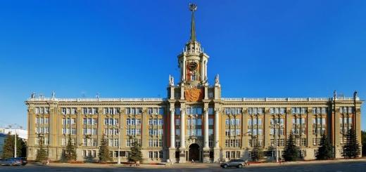
In ancient times, the central part of the Crimean Peninsula was occupied by the city-fortress of Naples Scythian - the capital of the Scythian kingdom. Nowadays the capital of the Republic of Crimea is located here - the glorious city of Simferopol. It does not have access to the sea. The Saligir River flows here is the longest river of Crimea.
As the main transport node of the peninsula, the city justifies its name, which from ancient Greek translates as a "city of benefit", "Gathering City". However, collects Simferopol not only random guests who perceive the city as an intermediate point on the way to the Black Sea coast, but also connoisseurs of history. After all, in the guise of the city, the whole epochs captured. The memory of La Frosfkih State stores the town of Naples Scythian, located on Petrovsky rocks. A peculiar symbol of the Crimean-Tatar city of Aquampus, the predecessor of Simferopol, is the Kubir jami mosque - the oldest building in the city, known since the beginning of the XVI century. And finally, the beginning of the Russian period in the life of the Crimean city is denoted by the Orthodox churches of the late XVIII - XIX centuries. Almost the same age of Simferopol is the Konstantino-Elenin Church - the first christian church cities. His greatness admire the ancient cathedrals - Petropavlovsky, Holy Trinity. Interestingly the cult factor of the Karaimov - Kenass, erected at the end of the XIX century. During the Great Patriotic War, Simferopol accepted a powerful enemy blow by surviving German occupation. The feat of the defenders of the city perpetuated monuments placed in his parks and squares.
The most complete idea of \u200b\u200bnature, history and culture is not only Simferopol, but also the entire republic of the Crimea give the main museums of the city - the Central Museum of Taurida, the Crimean ethnographic and Simferopol artistic museums. The city has the oldest Theater of Crimea - Russian Drama Theater. M. Gorky, as well as the Music Theater of the Republic of Crimea, the theater of dolls and the world's only Theater of the Crimean Tatars.
Simferopol is famous for its unique green zones. It is impossible to bypass the vintage parks based in the XVIII-XIX centuries. A special place among them is the Botanical Garden of the Tauride National University (Park "Salgirka" or Vorontsovsky Park) - one of the largest and most beautiful parks of Simferopol. Picturesque and cozy young city squares.
Read completely Turn Sightseeing, Panoramic View, Museum, Religion, Historical Monument
The most east and the most ancient city of Crimea is the city of Kerch, whose age has passed behind the colossal figure - twenty-six centuries! One of the hills of the city - Mount Mitridat is its historical and geographical center, a place where at the end of the 6th century BC. e. The future kerch originated, and then - the ancient Greek Policy of Panticapy, who became in 479 BC. The capital of the Bosporian kingdom. The ruins of his acropolis are now a unique monument of the era of antiquity and one of the main attractions of Kerch.
In addition to PentaPay, there are other ancient settlements - Nymphi, Tyritaka, Mirmekii in Kerch. Many artifacts found during the excavations of the township are presented in the famous Kerch Museum of Antiquities. Before our time, monuments of the funeral architecture of the IV century were also preserved. BC. - Tsarsky and Melek Chesmensky Kurgan.
Until 1774, that is, before Kerch's accession to Russia, the city visited many states: the Byzantine Empire, Khazar Kaganate, the Genoese Republic, the Ottoman Empire. The witness of many historical events was the church of St. John the Forerunner - the oldest Orthodox church of the Crimean Peninsula, the time of construction of which is related to the period between VIII and IX centuries.
Kerch is the honorary title of the city of Hero. In the period of the Great Patriotic War, the front line passed four times through Kerch, in 1941-1944 there was a severe occupation mode. Soon after the liberation of the city, a memorial complex was created on top of Mount Mountain - obelisk of glory immortal heroes and eternal flame.
On the top of the mountain, there are 423 steps of a large Mithridate staircase, which is an outstanding architectural monument of the first half of the XIX century. From the top viewing platform, the stairs opens a magnificent panorama of the city and the Kerch Strait.
Read completely Turn Museum, landmark, religion, historical monument
Evpatoria, stretching along the Kamitsky bay from the western coast of the Crimea Peninsula, is known primarily as a resort city. Each summer season, the number of tourists travelers is several times the number of its population. The enormous popularity of a small city is definitely due to the presence of beautiful beaches with golden sand and a shallow sea bottom, favorable climate (in the midst of the summer, the air temperature, as a rule, is kept at + 26-28 ° C). However, limited to coastal areas, it is impossible to make a holistic idea of \u200b\u200bthe city whose history goes deep into centuries.
In the place of Evpatoria with V c. BC e. At the end of II century. n. e. There was one of the ancient Greek colonies - Kerkinitid. The estimated facility is the most valuable archaeological complex, and the ruins of the city wall Kerkinitida today is one of the main historical relics Evpatoria. The Greek settlement was destroyed by Scythians. The city here again arose during the time of Crimean Khanate. He was called Kezlev (tour. Gözlevé). The sonor name of Evpatoria, which from Greek translates as "noble", the city received after the Crimea became part of the Russian Empire.
Typical eastern city Middle ages is the eastern part of modern Evpatoria, the so-called Old city. The area is distinguished by narrow street curves and ancient buildings. The age of some of the buildings of the historic part exceeds 500 years, among them - the Cathedral Mosque of Khan-Jami, laid back in 1552.
The unique historical and architectural and religious monument in Evpatoria - the teach of the dervish is the only Muslim monastery in the Crimea, based at the end of the XV - XVI centuries. No less interest is a complex of cult structures of the beginning of the XIX century - Keraim Kenassy. Outstanding monuments of Russian temple architecture are pre-revolutionary Orthodox Churches - St. Nicholas Cathedral, Church of the Holy Elijah.
The resort history of the city began at the end of the XIX century, when the first mud, where the healing mud of Moinka Lake was used. Subsequently, therapeutic properties of dirt and water of other lakes of Evpatoria were discovered. On the territory of the resort there are several mineral springs that, in conjunction with other numerous natural factors, rest in Evpatoria is incredibly useful.
Read completely Turn Museum, landmark, architectural monument, panoramic view
A magnificent pearl shines on the southern shores of the Crimean Peninsula - Beauty Yalta. This is one of the most sun resorts Crimea, city with luxurious nature and rich cultural Heritage. It is interesting that the status of the city and the glory of the fashionable resort of Yalta acquired only in the XIX century, although her story began much earlier ...
Once at the place of the future city, there was a small village of Yulos on the picturesque coast of the Black Sea (from Greek. - "Shore"), founded in the VI-V centuries BC Greek navigators. Like other cities of Crimea, the settlement has repeatedly moved from hand to hand: from the Tauric Greeks to the Venetians, then to the Genoesers, Byzantines; Later he was in possession of the Principality of the Feodoro, the Ottoman Empire, and, finally, Russia. Cardinal changes occurred in the middle of the XIX century, when small city, In the recent past, a fishing village, the highest government officials drew attention. In the 1860s, the nearest Yalta suburb - Livadia - becomes a summer residence of the royal family. And already to the outcome of the century XIX century, Yalta turns into a prestigious place of rest of the Russian aristocracy. It is by this time that the creation of fairytale palaces (Livadia, Massandrovsky, Vorontsovsky), noble estates and mansions, organically inscribed in the mountain landscape. In the pre-revolutionary times of Yalta attracted noble foreign guests. So, for example, the German oilman Baron P. Steingel, who loved to relax in the Crimea, in 1912, on the edge of an aurry rock was built gothic castle - the famous "swallow nest".
Do not detracting the values \u200b\u200band beauty of palace-park ensembles, the championship in the ranking of the attractions of the region will give the Yalta nature. Enclosed in the stone arms of the Crimean Mountains, Yalta is open only by sea and the sun. The terrain is extremely diverse. There are mountain ranges here, one of which includes the famous peak of Ai-Petri; hills covered with thick pine and beech forests; deep gorges with waterfalls; Valley of the mountain rivers, on one of which is formed the most big waterfall In Crimea - Waterfall Studed-Su Height 98 meters. Yalta, drowning in greenery, boasts an abundance of exotic plants: palm trees, cypresses, magnolia, wisteria grow here ...
One of the most beautiful places in the city and the most visited street in Crimea is the Embankment of Yalta. Today is a developed resort area with numerous restaurants, cafes, attractions. The Embankment is the President Hotel Tavrida, earlier - the hotel-eponymous hotel, where Rimsky-Korsakov, Nekrasov, Chekhov, Bunin, Mayakovsky, Stanislavsky, Shalyapin stopped at different times. Not far from the hotel building is the entrance to cable road Yalta Gorka, which gives the opportunity to enjoy the views of the city from a bird's eye view.
In the Feodosia at different times they lived outstanding figures of art and literature - the world famous marine artist IK Aivazovsky, whose name today wears the Feodosian art gallery; An outstanding writer, the brightest representative of neoromantism A. Green, who is devoted to the literary and memorial museum in Feodosia. About the history, culture, natural wealth of the South-Eastern Crimea narrates the Feodosia Museum of Local Lore, which is the oldest provincial museum institution of Russia.
During the Great Patriotic War, the city survived the German occupation. Here were fierce battles that led to significant destruction. For courage, resistance and mass heroism of Feodosia was awarded the honorary title - the city of Military Glory.
Read completely Turn Landmark, Religion, Historical Monument
City Fortress Alouston is known from the VI century. Strengthening, built on the orders of the Byzantine Emperor Justinian I, retained the role of an important coastal defensive point for all the states who owned them in the Middle Ages: the Byzantine Empire, Khazar Kaganate, the Principality of Feodoro. The fortress has lost its strategic importance after the conquest of the Crimea by the Turks. The ruins of an ancient structure preserved to this day are one of the main attractions of the peninsula.
Like Yalta, Alushta by the end of the XIX century, from a quiet seaside village turned into popular resort. Among curious pre-revolutionary buildings - the mansion of General Golubova, known as the dacha "dove"; Mansion merchant N.D. Stakheva, Palace of Prince Gagarina. In 1941-1944 The city was in German occupation. A number of monuments of Alushta are devoted to military historical events.
Shortly after the end of the war, in the middle of the last century, the real tourist boom began in Alushta, when dozens of sanatoriums and boarding houses opened here. Today the city still attracts rest. There is a large number of beaches on its territory, there is an aquarium with a large collection of freshwater and marine fish, dolphinarium, interesting museums.
Alushta, located in an extensive valley on the southern coast of Crimea, the Amphitheater surrounds the Crimean Mountains. From the West over the city there is a high massif of babugan-iala, in the north-west - Mount Chatyr-Dag, in the north - Demerji. The slopes of the mountains are covered with dense beech and pine forests. The picturesque surroundings of Alushta were shooting the famous Soviet films "Caucasian Captive", "Hearts of Three", "ships storm bastions" and others.
Read completely TurnView all objects on the map
Photos and text SAM NAMOS
Arriving on the train from Sevastopol in Bakhchisarai, sitting on a bus, next to the village of Strieldel. This is an extreme point where you can get in transport. Up the gorge rises a pedestrian road to the Holy Assumption Cave Monastery:
Place worth attention. Rocks right in the sheer cut of the cliffs, the grots in which the Celi of the monks are placed:
The Holy Assumption Cave Male Monastery is founded by Byzantine monks-iconistors no later than the VIII century. Located in the tract Mariam-Dere (Maria Gorge) near Bakhchisaraya. During the first defense of Sevastopol in the Crimean War in 1854-1855 in the cells, the house of pilgrims and other buildings of the monastery was located hospital. The dead from the Russian Academy of Sciences buried on the monastery cemetery. In 1921, the monastery was closed by the Soviet authorities.
After the resettlement from the Crimea to other regions of the USSR in 1941, Germans, Armenians, Bulgarians, Greeks, and in 1944 - Crimean Tatars, a psychoneurological dispensary is located on the territory of the monastery for decades. In 1993, the Ukrainian Orthodox Church was returned. Three of the five monastic temples are restored, the cellets, the rector and the bell tower.
At the bottom of the gorge, construction work is underway to expand the monastic complex.
Inside the picture did not work because On us with the move pounced the rectors convincing that the Lord himself was banned on the territory of the monastery ...
We go around all the rooms available for viewing and heading above the road, to the cave city - the Chufut Fortress - Kale:
On the way, our attention comes across a non-unique information indicator, which stals about the grand finding of the 21st century:
The find turned out to be an ancient 45-meter sedimention of the Chufut Fortress - Kale:
The construction is a mine with a suitable 120-meter gallery. The volume of work for that time is colossal:
Fork. The gallery on the right is flooded and in a dozen meters rests on a dead end:
Gallery on the left goes into a mine with a leaving spiral down the staircase, wounded right in the rock:
At the very bottom, by the plan of the creators, accumulated, and then climbed the purest water:
From above, the well of the well has access to the surface:
From the ground it looks like this:
Nearby, at the foot of the Chufut-Kale fortress, there is another one, much more modest on scale, an artesian well. Previously, he was also located in the thicker of the breed, but either a piece of rock fell off, whether the archaeologists gave the wall, and now he is a cut right at the foot of the fortress:
It's time to look inside the fortress. Two gates lead inside: Kiyuk Kapu (in the East) and Kuchuk-Kapap (south-west). From other sides the fortress is almost impregnable. However, we decided to climb from sports interest on the wall, just north of the Kiyuk-Kapa gate, where there is a weak place. You can boil with minimal mountaineering skills. By the way, the entrance to the territory of the fortress is paid.
Kiyuk Kapu Gate:
Small reference:
Chufut-Kale is a medieval fortress city located 2.5 km from Bakhchisaraya. The once fortress was the capital of the Crimean Khanate. The name is translated from the Crimean-Tatar language as the "Jewish Fortress", because the Tatars considered the Jews living there because of the similarities of their religion with Judaism.
The city arose presumably in the V century as a fortified settlement on the border of Byzantine possessions. Starting from the XIV century in the city and began to shave the carims, which by the time of the formation of the Crimean Khanate was already most of the population of the city. Chufut-Kale remained the main center of Karaimov Crimea until the middle of the XIX century, but gradually empty - the residents moved from a small plateau in more comfortable space.
Watch inside the fortress is almost nothing. Most of the space is covered with thickets. In the center of the territory passes an old stone road with a knocked rut from the wagon.
WITH southeast The parties are a small complex of economic caves and several buildings. Large and small Kenassa (prayer house of Karaimov):
Gate Kuchut-Kapu (South Log In):
Complex of economic caves:
The former rich estate with the system of underground rooms of Chaus-Kobasi ("Chief Caves") in the northern part of the fortress:
On the approach to the descent in the grotto, I heard a beautiful violin melody, dinking from under the ground:
Inside played violinist. As soon as I wanted to take a picture of him, he immediately ran away in the frame of his case. Acoustics is just incredible here! If it were not for violinist, I would have shouted there:
Next room:
In the same part of the fortress there is a sightseeing site. From here, there is a stunning view of Biyuk-Ashlama-Terla beam and Mount Besh Kosh.
After it is completely dark, we put forward in the direction of the Mountain Tepo-Kerman:
I do not know how much wandering on the forest paths would be launched, we are not stumbled upon, in the parking lot of experienced tourists who prompted the right road to us. Do not risk looking for cave cities in printouts satellite maps and applications on smartphones. Almost all the space in the trees, behind the tops that is practically nothing can be seen, and the satellite binding on the phone is also blossoming for an indecent distance. It is time for me to acquire a real GPS navigator.
By midnight, we still ended up at the top of the plateau. Lifting to the mountain is not pleasant to the mountain. The slope is very sharp and the path now and then it lures under your feet:
Small reference:
Cave city of Tepe-Kerman I existed in the period from VI to the XIV century and the greatest flourish was reached in the XII-XIII centuries. The peculiarity of Tepe-Kerme is the greatest, compared with other cave cities, Cave concentration. On an area of \u200b\u200babout 1 hectare there are more than 250. The main part of the city was on the top of the plateau (540 meters above sea level).
The overwhelming number of intracable structures here (about 85%) was used for economic needs. Of these, about 88%, or 170-180 premises, were gess for animals. The rest of the economic premises was represented by the umbores of the estates, water storage tanks. Incompute caves were used for housing and burial.
In many caves there is a hole in the ceiling (most likely for smoke removal). Walking on the plateau should be extremely careful. Many of these holes are almost not noticeable among the thickets:
One of the most remarkable grottoes cave complex - "Church with Baptistery" (church with church). Located on the northeast edge of the plateau:
The death of the city is tied by some versions to a focus of the Golden Town Bectery Beklaribek in 1299.
The parking lot was decided to arrange on the so-called "Dragon Tooth" right in one of the grots. All the plateau is blown away by a slight wind. The place turned out to be very cozy, and we mentally celebrated the last night of our trip in the Crimea with a small bone:
Waking up in the morning, I was dumbfounded by a view from a recession of a plateau. From the ledge, a panorama for tens of kilometers was opened.
The Territory of Crimea was settled 3,000 years ago. Its indigenous inhabitants were brand, famous for the militant character and a tendency to piracy. More precisely, this is the first people who managed to find out reliable information. The archaeologists were found to be found ancient parking lot, the age of which exceeds 1 million years. The favorable location of the peninsula at the intersection of trade routes determined his fate, complete conquests. Here we managed to visit the Greeks and Venetians, Scythians and Romans, Goths and Gunns, Genoese and Turks, Tatars and Slavs. Saturated historical past and traces of various cultures led to the formation in the region in different epochs of many diverse settlements, many of which exist so far.
Top 10 Oldest Cities Crimea
Many ancient and earlier settlements that existed in the Crimea were not preserved. The most famous of them were:
- Chersonese Tauride - based in the antiquity of the Greeks, is now on the territory of Sevastopol and the UNESCO is protected;
- Panticapy - the capital of the powerful Bosporian kingdom, the ruins of which are now on Mitridat in Kerch;
- Kerkinitida is a settlement created by the ancient Greeks, on the site of which Evpatoria is now.
The Crimean Republic includes 16 cities, and only two of them are based in the past century: Krasnoperekopsk in 1932 and shortcino in 1978. The rest boast of a rich, rich history: at least three appeared more than two thousand years ago, and the formation of a significant part of others Associate on the era of the Middle Ages.
The most ancient cities of the Crimea, from among the current existing ones, includes:
- Kerch - VII century BC e.
- Feodosia - VI century BC. e.
- Evpatoria - 497 BC e.
- Sudak - 212 year.
- Alushta - VI century.
- Alupka - 960 year.
- Yalta - 1154 year.
- Old Crimea - XIII century.
- Belogorsk - XIII century.
- Bakhchisarai - 1389 year.
Kerch - the most ancient in the Crimea
Ancient city The Crimean Peninsula stands in the eastern part of it to Kerch. Archaeological studies show that people lived on the local lands already 100,000 years ago, and in the center of Kerch, scientists found a mammoth tooth. More than 60 parking belongs to later era of Mesolitis and Neolithic. First, the local primitive population was engaged in fishing and hunting, later mastered the cattle breeding and craft.

Real History Cities began in the VII century BC. If, when the neighboring regions, the Greek seaflors were actively based on the Black Sea for new colonies. One of them was the settlement of Panticapy: it was located on the hill - Mount Mitridat, and was surrounded by other, less famous settlements. Subsequently, they all merged together, forming the city zone of modern Kerch. In 480 BC e. The peak peak of Pantikathey came when he took the title of the capital of the Bosporian kingdom - one of the most powerful in the region at that time. Since then, the ruins of the temple of Apollo, the royal kurgan of the king of the Dynasty of Spartokidov and an impressive necropolis.
By the fourth century of the new millennium, after an unsuccessful era of the board of the Tiberiyev Dynasty of Yuliyev and the Gunnian invasion, Panticapy finally lost any important importance. Two centuries later, Turks came here, who called the settlement of Karsha, which meant "the other coast". In the X century, the lands were traded by Slavs, wringing toponym on their way: Korchev. After them owned the Genoese, then the Turks, and then the Russians. From this period in Kerch, military fortresses were left: Turkish Yeni-Kale and Russian Kerch, the construction of the XVIII and XIX centuries, respectively. The main attraction of the resort, Mithridataya staircase, appeared only in the middle of the last century, but climb on it is for the sake of stunning panoramas.
Feodosia - an old picturesque town
Almost simultaneously with Kerch, and the forces, all the same Miletsky Greeks, was founded by Feodosia. Unlike the famous neighbor according to the rating, Feodosia in Antiquity did not differ special, but in 2015 he received the honorary title of the city of military glory for the merits of the Ministry of Rocky Defense of the Fatherland.

The date of formation of the settlement of the utensils indicate the VI century BC. er., since the exact data on the appearance time does not exist. However, it is reliably known that from 355 BC. e. It already belonged to the territory of the Bosporus kingdom. In this regard, further destinies of settlements are similar: Huns, Byzantines, Tatars, Genoese. The latter brought a small settlement of the Golden Epoch: Renamed the town in Cafa. Genoesers made it important trading trading port and the administrative center, from where they managed to all northern Black Sea: By the 20th century, he could already compare with Constantinople.
They gave the Feodosia and the main tourist attraction today: a defensive fortress from limestone buildings of the XIV century. Previously, she enveloped the territory of 70 hectares, and today it is well preserved only the southern part of it and several towers, among whom the tower of St. Constantine with mounted braces deserves special attention.
Evpatoria - beautiful and historically attractive
By the fifth century, or rather by 497 BC, the appearance of Evpatoria is the best modern children's balneo-mud climatic resort not only the Crimea, but also of all countries of the post-Soviet space. On the healing properties of local mud were known from the ancient period, when it was formed the first reliably known settlement - Kerkinitida. The settlement was located on the shores of the Kamitskiy Bay and Mant, today wearing a name quarantine.

According to some reports, the Greeks from Ionia arrived here for an eyelid earlier, and by the IV century, the past era was able to create a prosperous trade settlement, which existed in the status of an independent policy, who independently developed its own economy. Such a state of affairs lasted not long: in the same century it enters into dependence on the Kherson kingdom. And if the development continued with it, the Scythians, and then the Gunnes were destroyed. In the Middle Ages, the Turks are based here the HEZLO Fortress here, and in 1784 by Decree Catherine II, the settlement received the status of the city and was renamed Evpatoria in honor of the famous ruler of Mithridate VI Evpator, which was ruled in Antiquity in Kerch.