Without the Russian discoverers, the world map would have been completely different. Our compatriots - travelers and seafarers - have made discoveries that have enriched world science. The eight most noticeable are in our material.
Bellingshausen's first Antarctic expedition

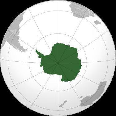
In 1819, the navigator, captain of the 2nd rank, Thaddeus Bellingshausen led the first Antarctic round-the-world expedition. The purpose of the voyage was to explore the waters of the Pacific, Atlantic and Indian oceans, as well as proof or refutation of the existence of the sixth continent - Antarctica. Having equipped two sloops - "Mirny" and "Vostok" (under command), Bellingshausen's detachment went to sea.
The expedition lasted 751 days and wrote many bright pages in history geographical discoveries... The main one - - was made on January 28, 1820.
By the way, attempts to open the white continent were made earlier, but they did not bring the desired success: they lacked a little luck, or maybe Russian tenacity.
Thus, the navigator James Cook, summing up the results of his second voyage around the world, wrote: "I went around the ocean of the southern hemisphere at high latitudes and rejected the possibility of the existence of a continent, which, if it can be discovered, then only near the pole in places inaccessible for navigation."
During Bellingshausen's Antarctic expedition, more than 20 islands were discovered and mapped, sketches of Antarctic species and animals living on it were made, and the navigator himself went down in history as a great discoverer.
“The name Bellingshausen can be directly put alongside the names of Columbus and Magellan, with the names of those people who did not give up before the difficulties and imaginary impossibilities created by their predecessors, with the names of people who followed their own independent path, and therefore were the destroyers of obstacles to discoveries, which designate epochs, ”wrote the German geographer August Petermann.
Discovery of Semyonov Tien Shansky

Central Asia at the beginning of the 19th century was one of the least explored regions of the world. An indisputable contribution to the study of the "unknown land" - as geographers called Central Asia - was made by Peter Semyonov.
In 1856, the main dream of the explorer came true - he went on an expedition to the Tien Shan.
“My works on Asian geography led me to a thorough acquaintance with everything that was known about inner Asia. Beckoned me in particular to itself the most central of the Asian mountain ranges - the Tien Shan, which had not yet been set foot by a European traveler and which was known only from scant Chinese sources.
Semenov's research in Central Asia lasted two years. During this time, the sources of the Chu, Syrdarya and Sary-Dzhaz rivers, the Khan-Tengri peaks and others were mapped.
The traveler established the location of the Tien Shan ridges, the height of the snow line in this area and discovered the huge Tien Shan glaciers.
In 1906, by decree of the emperor, for the merits of the discoverer, the prefix was added to his surname - Tien Shansky.

Asia Przewalski

In the 70's and 80's. XIX century Nikolai Przhevalsky led four expeditions to Central Asia. This little-studied area has always attracted the explorer, and a trip to Central Asia was his old dream.
Over the years of research, mountain systems have been studied Kun-Lun , ridges of Northern Tibet, the sources of the Yellow River and Yangtze, basins Kuku-nora and Lob-nora.
Przewalski was the second person after Marco Polo to reach lakes-swamps Lob-nora!
In addition, the traveler discovered dozens of plant and animal species that are named after him.
“Happy fate made it possible to carry out a feasible study of the least known and most inaccessible countries of inner Asia,” Nikolai Przhevalsky wrote in his diary.
Kruzenshtern's circumnavigation

The names of Ivan Kruzenshtern and Yuri Lisyansky became known after the first Russian round-the-world expedition.
For three years, from 1803 to 1806. - that is how long the first circumnavigation lasted - the ships "Nadezhda" and "Neva", passing through Atlantic Ocean, circled Cape Horn, and then the waters The Pacific reached Kamchatka, the Kuril Islands and Sakhalin. The expedition refined the map of the Pacific Ocean, collected information about the nature and inhabitants of Kamchatka and the Kuriles.

During the voyage, Russian sailors crossed the equator for the first time. Celebrated this event, according to tradition, with the participation of Neptune.
The sailor, dressed in the lord of the seas, asked Kruzenstern why he came here with his ships, because earlier Russian flag in these places have not been seen. To which the commander of the expedition replied: "For the glory of science and our fatherland!"
Expedition of Nevelskoy

Admiral Gennady Nevelskoy is rightfully considered one of the outstanding navigators of the 19th century. In 1849 he went on an expedition to the Far East on the transport ship "Baikal".
The Amur expedition lasted until 1855, during which time Nevelskoy made several major discoveries in the area of the lower Amur and northern shores Sea of Japan, annexed to Russia the vast areas of the Amur and Primorye.
Thanks to the navigator, it became known that Sakhalin is an island, which is separated by the navigable Tatar Strait, and the mouth of the Amur is accessible for ships to enter from the sea.
In 1850, a detachment of Nevelskoy founded the Nikolaev post, which today is known as Nikolaevsk-on-Amur.
“The discoveries made by Nevelskoy are invaluable for Russia,” wrote Count Nikolai Muravyov-Amursky - many previous expeditions to these lands could achieve European glory, but none of them achieved domestic benefits, at least to the extent that Nevelskoy did it. "
Vilkitsky North

The purpose of the hydrographic expedition of the Arctic Ocean in 1910-1915. was the development of the Northern Sea Route. By chance, the duties of the head of the voyage were taken over by the captain of the 2nd rank Boris Vilkitsky. Icebreaking ships "Taimyr" and "Vaygach" went to sea.
Vilkitsky moved along the northern water area from east to west, and during the voyage he managed to compose a true description north coast Eastern Siberia and many islands, received the most important information about the currents and climate, and also became the first who made a through voyage from Vladivostok to Arkhangelsk.
The expedition members discovered the Land of Emperor Nicholas I. I., known today as New earth- this discovery is considered the last of the significant the globe.
In addition, thanks to Vilkitsky, the islands of Maly Taimyr, Starokadomsky and Zhokhov were mapped.
At the end of the expedition, the First World War... The traveler Roald Amundsen, having learned about the success of Vilkitsky's voyage, could not resist exclaiming to him:
"In peacetime, this expedition would excite the whole world!"

Kamchatka campaign of Bering and Chirikov

The second quarter of the 18th century was rich in geographical discoveries. All of them were made during the First and Second Kamchatka expeditions, which immortalized the names of Vitus Bering and Alexei Chirikov.
During the First Kamchatka campaign Bering - the leader of the expedition and his assistant Chirikov explored and mapped the Pacific coast of Kamchatka and Northeast Asia. They discovered two peninsulas - Kamchatsky and Ozerny, Kamchatsky Bay, Karaginsky Bay, Cross Bay, Providence Bay and St. Lawrence Island, as well as the strait, which today bears the name of Vitus Bering.
Companions - Bering and Chirikov - also led the Second Kamchatka Expedition. The goal of the campaign was to find a way to North America and explore the islands of the Pacific Ocean.
In Avacha Bay, the expedition members laid the foundation for the Petropavlovsk prison - in honor of the ships of navigation "St. Peter" and "St. Paul" - which was later renamed Petropavlovsk-Kamchatsky.

When the ships sailed to the shores of America, by the will of evil fate, Bering and Chirikov began to act alone - because of the fog, their ships lost each other.
"St. Peter" under the leadership of Bering reached the western coast of America.
And on the way back, the members of the expedition, who had a lot of difficulties, were thrown into a small island by a storm. Here Vitus Bering's life ended, and the island where the expedition members stopped for the winter was named after Bering.
"St. Paul" Chirikov also reached the shores of America, but for him the voyage ended more safely - on the way back, he discovered a number of islands in the Aleutian ridge and returned safely to the Peter and Paul prison.
Ivan Moskvitin's "Tumbling Lands"

Little is known about the life of Ivan Moskvitin, but this man still went down in history, and the reason for this is the new lands opened to him.
In 1639, Moskvitin, leading a detachment of Cossacks, set sail for the Far East. The main goal of the travelers was “to find new unseasoned lands”, to collect furs and fish. The Cossacks overcame the Aldan, Mayu and Yudomu rivers, discovered the Dzhugdzhur ridge, which separates the rivers of the Lena basin from the rivers flowing into the sea, and along the Ulya river entered the "Lamskoye" or Okhotsk Sea. Having explored the coast, the Cossacks discovered the Tauiskaya Bay and entered the Sakhalin Bay, circling the Shantar Islands.
One of the Cossacks reported that the rivers in open lands"Sable, there are many animals, and fish, and the fish is big, there is no such thing in Siberia ... there is so much of it - just run the seine and you can't drag the fish out with the fish ...".
The geographical data collected by Ivan Moskvitin formed the basis for the first map of the Far East.
>> Russian discoverers and travelers
§ 16. Russian discoverers and travelers
The 19th century was the time of the largest geographical discoveries made by Russian explorers. Continuing the traditions of their predecessors - explorers and travelers of the 17th-18th centuries, they enriched the ideas of Russians about the world around them, contributed to the development of new territories that became part of the empire. Russia first implemented old dream: her ships entered the oceans.
I.F.Kruzenshtern and Yu.F. Lisyansky.
Lesson content lesson outline support frame lesson presentation accelerative methods interactive technologies Practice tasks and exercises self-test workshops, trainings, cases, quests homework discussion questions rhetorical questions from students Illustrations audio, video clips and multimedia photos, pictures charts, tables, schemes humor, jokes, jokes, comics parables, sayings, crosswords, quotes Supplements abstracts articles chips for the curious cheat sheets textbooks basic and additional vocabulary of terms others Improving textbooks and lessonsbug fixes in the tutorial updating a fragment in the textbook elements of innovation in the lesson replacing outdated knowledge with new ones For teachers only perfect lessons calendar plan for the year methodological recommendations of the discussion program Integrated lessonsRussian navigators, along with European ones, are the most famous pioneers who discovered new continents, sections of mountain ranges and vast water areas.
They pioneered significant geographic sites, took the first steps in the development of hard-to-reach territories, traveled around the world. So who are they - the conquerors of the seas, and what exactly did the world learn about thanks to them?
Afanasy Nikitin - the very first Russian traveler
Afanasy Nikitin is rightfully considered the first Russian traveler who managed to visit India and Persia (1468-1474, according to other sources 1466-1472). On the way back, he visited Somalia, Turkey, Muscat. On the basis of his travels, Afanasy compiled the notes "Voyage across the Three Seas", which became popular and unique historical and literary textbooks. These records became the first book in the history of Russia, made not in the format of a story about a pilgrimage, but describing the political, economic and cultural characteristics of the territories.
Afanasy Nikitin
He was able to prove that even as a member of a poor peasant family, one can become a famous explorer and traveler. Streets, embankments in several Russian cities, a motor ship, passenger train and the airport
Recommended to read 
Semyon Dezhnev, who founded the Anadyr prison
Cossack chieftain Semyon Dezhnev was an Arctic navigator who became the discoverer of a number of geographical objects. Wherever Semyon Ivanovich served, everywhere he strove to study new and previously unknown. He was even able to cross the East Siberian Sea on a makeshift koch, going from Indigirka to Alazeya.
In 1643, as part of a detachment of researchers, Semyon Ivanovich discovered Kolyma, where, with his associates, he founded the city of Srednekolymsk. A year later, Semyon Dezhnev continued his expedition, walked along the Bering Strait (which did not yet have this name) and discovered the easternmost point of the continent, later called Cape Dezhnev. Also, an island, a peninsula, a bay, a village are named after him.

Semyon Dezhnev
In 1648, Dezhnev hit the road again. His ship was wrecked in the waters located in the southern part of the Anadyr River. Having reached on skis, the sailors went up the river and stayed there for the winter. Subsequently, this place appeared on geographical maps and received the name Anadyr prison. As a result of the expedition, the traveler was able to make detailed descriptions and make a map of those places.
Vitus Jonassen Bering, who organized expeditions to Kamchatka
Two Kamchatka expeditions inscribed the names of Vitus Bering and his associate Alexei Chirikov in the history of sea discoveries. During the first voyage, the mariners conducted a study and were able to supplement the geographical atlas with objects located in Northeast Asia and on the Pacific coast of Kamchatka.
The discovery of the Kamchatka and Ozerny peninsulas, the bays of Kamchatsky, Krest, Karaginsky, the Providence Bay, the island of St. Lawrence is also the merit of Bering and Chirikov. At the same time, another strait was found and described, which later became known as the Bering Strait.

Vitus Bering
The second expedition was undertaken by them with the aim of finding a way to North America and exploring the Pacific Islands. On this journey, Bering and Chirikov founded the Peter and Paul prison. It got its name from the combined names of their ships ("St. Peter" and "St. Paul) and later became the city of Petropavlovsk-Kamchatsky.
On the approach to the shores of America, the ships of like-minded people lost sight of each other, a heavy fog affected. "St. Peter", piloted by Bering, sailed to the west coast of America, but got into a violent storm on the way back - the ship was thrown onto the island. The last minutes of Vitus Bering's life passed on it, and the island subsequently began to bear his name. Chirikov also reached America on his ship, but safely completed his voyage, having discovered several islands of the Aleutian ridge on the way back.
Khariton and Dmitry Laptev and their "named" sea
Cousins Khariton and Dmitry Laptev were Vitus Bering's associates and assistants. It was he who appointed Dmitry the commander of the ship "Irkutsk", and his double-boat "Yakutsk" was led by Khariton. They took part in the Great Northern Expedition, the purpose of which was to study and accurately describe and map the Russian shores of the ocean, from the Yugorsky sphere to Kamchatka.
Each of the brothers made a significant contribution to the development of new territories. Dmitry became the first navigator who made a survey of the shores from the mouth of the Lena to the mouth of the Kolyma. He made detailed maps of these places, based on mathematical calculations and astronomical data.

Khariton and Dmitry Laptev
Khariton Laptev and his associates conducted research on the northernmost part of the Siberian coast. It was he who determined the dimensions and outlines of the huge Taimyr Peninsula - he completed a survey of its eastern coast, was able to identify the exact coordinates of the coastal islands. The expedition took place in difficult conditions - a large number of ice, snowstorms, scurvy, ice captivity - Khariton Laptev's team had to go through a lot. But they continued their work. On this expedition, Laptev's assistant Chelyuskin discovered the cape, which was later named in his honor.
Noting the great contribution of the Laptevs to the development of new territories, members of the Russian Geographical Society decided to name one of the largest seas in the Arctic after them. Also in honor of Dmitry, the strait between the mainland and the island of Bolshoi Lyakhovsky is named, and the name of Khariton is West Coast Taimyr islands.
Kruzenshtern and Lisyansky - organizers of the first Russian circumnavigation
Ivan Kruzenshtern and Yuri Lisyansky are the first Russian navigators who made trip around the world... Their expedition lasted three years (started in 1803 and ended in 1806). They set off with their crews on two ships, which bore the names "Nadezhda" and "Neva". The travelers passed through the Atlantic Ocean, entered the waters of the Pacific Ocean. The sailors sailed along them to the Kuril Islands, Kamchatka and Sakhalin.

Ivan Kruzenshtern This journey allowed to collect important information... Based on data obtained by seafarers, detailed map The Pacific Ocean. Another important result of the first Russian round-the-world expedition was the data obtained on the flora and fauna of the Kuriles and Kamchatka, local residents, their customs and cultural traditions.
During their journey, the sailors crossed the equator and, according to maritime traditions, could not leave this event without a well-known ritual - a sailor disguised as Neptune greeted Kruzenshtern and asked why his ship had arrived where the Russian flag had never been. To which he received the answer that they were here exclusively for the glory and development of national science.
Vasily Golovnin - the first navigator who was rescued from Japanese captivity
Russian navigator Vasily Golovnin led two expeditions around the world. In 1806, while in the rank of lieutenant, he received a new appointment and became the commander of the sloop "Diana". Interestingly, this is the only case in the history of the Russian fleet when a lieutenant was entrusted with the control of the ship.
The leadership set the goal of a round-the-world expedition to study the North Pacific Ocean, with special attention to that part of it, which is located within the borders of the native country. Diana's path was not easy. The sloop passed the island of Tristan da Cunha, passed the Cape of Hope and entered a port belonging to the British. Here the ship was detained by the authorities. The British informed Golovnin about the beginning of the war between the two countries. The Russian ship was not declared captured, but the team was not allowed to leave the bay either. After spending more than a year in this position, in mid-May 1809 "Diana", led by Golovnin, tried to escape, which the sailors successfully succeeded in - the ship arrived in Kamchatka.

Vasily Golovin The next important assignment Golovnin received in 1811 - he had to compose descriptions of the Shantar and Kuril Islands, the shores of the Tatar Strait. During his travels, he was accused of violating sakoku principles and captured by the Japanese for more than 2 years. The team was rescued from captivity only thanks to the good relations between one of the Russian naval officers and an influential Japanese merchant, who was able to convince his government of the harmless intentions of the Russians. It is worth noting that before that, no one in history had returned from Japanese captivity.
In 1817-1819 Vasily Mikhailovich made another round-the-world voyage on the ship "Kamchatka" specially built for this.
Thaddeus Bellingshausen and Mikhail Lazarev - discoverers of Antarctica
Captain Second Rank Thaddeus Bellingshausen was determined to find the truth in the question of the existence of the sixth continent. In 1819 he went out to sea, carefully preparing two sloops - "Mirny" and "Vostok". The latter was commanded by his associate Mikhail Lazarev. The first Antarctic round-the-world expedition set itself other tasks. In addition to finding irrefutable facts confirming or refuting the existence of Antarctica, the travelers were going to explore the waters of three oceans - the Pacific, Atlantic and Indian.

Thaddeus Bellingshausen The results of this expedition exceeded all expectations. For 751 days, which it lasted, Bellingshausen and Lazarev were able to make several significant geographical discoveries. Of course, the most important of them is the existence of Antarctica, this historical event took place on January 28, 1820. Also, during the trip, about two dozen islands were found and mapped, sketches with views of Antarctica, images of representatives of the Antarctic fauna were created.

Mikhail Lazarev
It is interesting that attempts to discover Antarctica were made more than once, but none of them was successful. European sailors believed that either it is not there, or it is located in places that simply cannot be reached by sea. But Russian travelers had enough perseverance and determination, so the names of Bellingshausen and Lazarev are included in the lists greatest sailors the world.
Yakov Sannikov
Yakov Sannikov (about 1780, Ust-Yansk, Russian Empire - after 1811) - Russian merchant from Yakutsk, fox, mammoth tusks and explorer of the New Siberian Islands.
He is known as the discoverer of the ghost island "Sannikov Land", which he saw from the New Siberian Islands. Discovered and described the islands of Stolbovoy (1800) and Faddeevsky (1805).
In 1808-1810 he took part in the expedition of the exiled Riga Swede M. M. Gedenshtrom. In 1810 he crossed the island of New Siberia, in 1811 he bypassed the island of Faddeevsky.
Sannikov expressed his opinion about the existence to the north of the New Siberian Islands, in particular from the Kotelny Island, a vast land called "Sannikov Land".

After 1811, traces of Yakov Sannikov are lost. No further occupation or year of death is known. In 1935, the pilot Gratsiansky, who flew in the lower reaches of the Lena River, near Kyusyur, discovered a tombstone with the inscription "Yakov Sannikov". The strait, through which a section of the Northern Sea Route passes today, is named in his honor. Opened in 1773 by the Yakut industrialist Ivan Lyakhov. Initially, the strait was named after the expedition doctor E.V. Tollya V.N. Katina-Yartseva F.A. Matisen. The current name was given to K.A. Vollosovich on his map, and in 1935 it was approved by the government of the USSR.
Grigory Shelikhov
Grigory Ivanovich Shelikhov (Shelekhov; 1747, Rylsk - July 20, 1795, Irkutsk) - Russian explorer, navigator, industrialist and merchant from the Shelekhov family, who since 1775 was engaged in the arrangement of commercial merchant shipping between the Kuril and Aleutian island ridges. In 1783-1786 he headed an expedition to Russian America, during which the first Russian settlements in North America were founded. He organized several trading and fishing companies, including in Kamchatka. Grigory Ivanovich mastered new lands for the Russian Empire, was the initiator of the Russian-American company. Founder of the North-East Company.

The bay was named after him. Shelikhov Bay (Kamchatka Region, Russia) is located between the Asian coast and the base of the Kamchatka Peninsula. Refers to the water area of the Sea of Okhotsk.
Ferdinand Wrangel
Wrangel showed himself from the best side, and he, tested in a difficult round-the-world voyage, is instructed to lead an expedition to the extreme northeast of Siberia, to the mouths of the Yana and Kolyma, in order to map the coast of the Arctic Ocean up to the Bering Strait, and in addition to test the hypothesis about the existence of an undiscovered land connecting Asia with America.
Wrangel spends three years in the ice and tundra with his companions, among whom his main assistant was Fyodor Matyushkin - Lyceum comrade A.S. Pushkin.
In the intervals between the campaigns to the North, under the leadership of Wrangel and Matyushkin, a topographic survey of the huge coast was made, covering 35 degrees in longitude. On the territory of the recently white spot, 115 astronomical points were identified. For the first time, studies were carried out on the influence of climate on the existence and development sea ice, and in Nizhnekolymsk was organized the first meteorological station in this region. Thanks to meteorological observations of this station, it was established that in the interfluve of the Yana and Kolyma rivers there is a "cold pole" of the Northern Hemisphere.
Ferdinand Wrangel described the expedition and its scientific results in detail in a book that was first published in 1839 and was a huge success. The renowned Swedish polar explorer Adolf Erik Nordenskjöld called it "one of the masterpieces among the writings on the Arctic."

The expedition to the Chukotka-Kolyma region put Wrangel on a par with the largest explorers of the harsh Arctic. Later, becoming one of the founders of the Russian Geographical Society, he thought over a project for an expedition to the North Pole. He proposes to go to the Pole on a ship, which should be wintering off the northern coast of Greenland, to prepare food warehouses along the route of the pole consignment in the fall, and in March people to leave exactly in the direction of the meridian on ten sledges with dogs. Interestingly, the plan to reach the pole, drawn up by Robert Peary, who entered the pole 64 years later, repeated Wrangel's old project in the smallest detail. An island in the Arctic Ocean, a mountain and a cape in Alaska are named after Wrangel. Having learned about the sale of Alaska by the Russian government in 1867, Ferdinand Petrovich reacted very negatively to this.
5 / 5 ( 145 votes)
Russian discoverers and travelers of the 19th century made a number of outstanding discoveries that became the property of not only Russian, but also foreign, world science. In addition, they made a significant contribution to the development of domestic knowledge and did a lot to facilitate the training of new personnel for the development of marine research.
Prerequisites
Russian discoverers and travelers of the 19th century made their discoveries in large part because this century indicated the need to search for new trade routes and opportunities to maintain ties between Russia and other countries. In the late 18th and early 19th centuries, our country finally consolidated its status in the international arena as a world power. Naturally, this new position expanded its geopolitical space, which required new exploration of the seas, islands and ocean coasts for the construction of ports, ships and the development of trade with foreign states.
Russian discoverers and travelers of the 19th century became talented navigators at the very time when our country achieved access to two seas: the Baltic and the Black. And this is no coincidence. This opened up new perspectives for naval research and gave impetus to the construction and development of fleets, and naval affairs in general. Therefore, it is not surprising that already in the first decades of the century under consideration, Russian discoverers and travelers of the 19th century carried out a number of outstanding studies that significantly enriched Russian geographical science.
Around the World Expedition Plan
Such a project became possible largely due to the successful military actions of our country at the end of the 18th century. At this time, Russia got the opportunity to build its own fleet in the Black Sea, which, of course, was supposed to stimulate maritime affairs. Russian seafarers at this time seriously thought about building convenient trade routes. This was also facilitated by the fact that our country owned the territory North America Alaska. It was also necessary to maintain constant contacts with her and develop economic cooperation.
I.F. At the end of the 18th century, Kruzenshtern presented a plan for a round-the-world expedition. However, he was then rejected. But just a few years later, after the accession of Alexander I, the Russian government showed interest in the presented plan. He got approval.

Training
I.F. Kruzenshtern came from a noble family. He studied at the Kronstadt Naval Corps and, being his student, took part in the war against Sweden, having established himself well then. After that, he was sent to an internship in England, where he received an excellent education. Upon returning to Russia, he presented a plan for a round-the-world expedition. Having received approval, he carefully prepared for it, purchased the best instruments and equipped the ships.
His closest assistant in this matter was his friend Yuri Fedorovich Lisyansky. He made friends with him while still in the cadet corps. The friend also proved himself to be a talented naval officer during the Russian-Swedish war of 1788-1790. Soon two ships were equipped under the names "Neva" and "Nadezhda". The latter was led by Count Nikolai Rezanov, who became famous thanks to the famous rock opera. The expedition set sail in 1803. Its goal was to explore and explore the possibility of opening new trade routes from Russia to China and the coast of North American territory.

Swimming
Russian sailors rounded Cape Horn and, having entered the Pacific Ocean, parted. Yuri Fedorovich Lisyansky led his ship to the North American shores, where he recaptured the Russian merchant city of Novo-Arkhangelsk captured by the Indians. During this trip, he also spent the first time in the history of navigation sailing ship around South Africa.
The vessel "Nadezhda" headed by Kruzenshtern set off for the Sea of Japan. The merit of this researcher is that he carefully explored the shores of Sakhalin Island and made significant changes to the map. The main thing was to research what the management had been interested in for a long time. Pacific Fleet... Kruzenshtern entered the Amur estuary, after which, having explored the shores of Kamchatka, he returned to his homeland.

Kruzenshtern's contribution to science
Travelers to Russia have significantly advanced Russian geographical science, bringing it to the world level of development. attracted the attention of the general public. After the end of the trip, both wrote books describing the results of their research. Kruzenshtern published A Journey Around the World, but his atlas with hydrographic supplements is of particular importance. He filled in many blank spots on the map, conducted the most valuable research of the seas and oceans. So, he studied the pressure and temperature of water, sea currents, ebbs and flows.
Social activity
His further career was closely associated with the naval corps, where he was first assigned as an inspector. Subsequently, he began to teach there, and then generally headed it. On his initiative, the Higher Officer Classes were created. Later they were transformed into the Maritime Academy. Kruzenshtern introduced new disciplines to educational process... This significantly increased the quality level of teaching maritime affairs.
In addition, he helped in organizing other expeditions, in particular, contributed to the plans of another prominent explorer O. Kotzebue. Kruzenshtern took part in the creation of the famous Russian Geographical Society, which was destined to take one of the leading places not only in Russian, but also in world science. The Atlas of the South Sea, published by him, was of particular importance for the development of geography.
Preparing a new expedition
Kruzenshtern, several years after his journey, insisted on a thorough study of the southern latitudes. He proposed to equip two expeditions to the North and South Poles, two ships each. Prior to this, the navigator almost came close to the Antarctic, but ice prevented him from going further. Then he assumed that the sixth continent either does not exist, or it is impossible to get to it.
In 1819, the Russian leadership decided to equip a new sailing squadron. Faddey Faddeevich Bellingshausen, after a series of delays, was appointed its leader. It was decided to build two ships: "Mirny" and "Vostok". The first was designed according to the plan of Russian scientists. It was distinguished by its strength and water resistance. However, the second, built in Great Britain, was less stable, so it had to be altered, rebuilt and renovated more than once. The preparation and construction was supervised by Mikhail Lazarev, who complained about such a discrepancy between the two ships.

Travel south
A new expedition set off in 1819. She reached Brazil and, having rounded the mainland, came to the Sandvic Islands. In January 1820, a Russian expedition discovered the sixth continent - Antarctica. During maneuvers, many islands were discovered and described around it. Among the most significant discoveries are the island of Peter I, the coast of Alexander I. Having made the necessary description of the shores, as well as sketches of animals seen on the new mainland, Faddey Faddeevich Bellingshausen sailed back.
During the expedition, in addition to the discovery of Antarctica, other discoveries were made. For example, participants discovered that Sandwich Land is an entire archipelago. In addition, the island of South Georgia has been described. Descriptions of the new continent are of particular importance. From his ship, Mikhail Lazarev had the opportunity to better observe the earth, so his conclusions are of particular value for science.

The value of discoveries
The expedition of 1819-1821 was of great importance for national and world geographical science. The discovery of a new, sixth continent, turned the idea of the geography of the Earth upside down. Both travelers published the results of their research in two volumes with an atlas attached and the necessary directions. During the trip, about thirty islands were described, magnificent sketches of the views of Antarctica and its fauna were made. In addition, the members of the expedition have collected a unique ethnographic collection, which is kept at the Kazan University.
Further activities
Bellingshausen subsequently continued his naval career. He participated in the Russian-Turkish War of 1828-1829, commanded the Baltic Fleet, and then was appointed governor of Kronstadt. An indication of the recognition of his merits is the fact that a number of geographical objects are named after him. First of all, the sea in the Pacific Ocean should be mentioned.
Lazarev also distinguished himself after his famous trip to Antarctica. He was appointed commander of the expedition to protect the shores of Russian America from smugglers, with which he successfully coped. Subsequently, he commanded the Black Sea Fleet, participated in for which he was awarded several awards. So, the great pioneers from Russia also made their outstanding contribution to the development of geography.
I. Kruzenshtern and Yu. Lisyansky In 1803 an expedition was undertaken to explore the northern part of the Pacific Ocean. It was the FIRST RUSSIAN EXPEDITION. It was headed by I. Kruzenshtern. For the first time, more than a thousand km of the coast of about Sakhalin. Lisyansky discovered one of the islands of the Hawaiian archipelago. Collected a lot of data on the Aleutian Islands and Alaska, the Pacific Islands and Arctic oceans... These materials served as the basis for Atlas South Seas". In 1803, an expedition was undertaken to explore the North Pacific. It was the FIRST RUSSIAN EXPEDITION. It was headed by I. Kruzenshtern. For the first time, more than a thousand km of the coast of about Sakhalin. Lisyansky discovered one of the islands of the Hawaiian archipelago. We have collected a lot of data about the Aleutian Islands and Alaska, the islands of the Pacific and Arctic oceans. These materials served as the basis for the Atlas of the South Seas.

F. Bellingshausen and M. Lazarev F. Bellingshausen headed a new round-the-world expedition. The plan was drawn up by I. Kruzenshtern. In F. Bellingshausen he headed a new round-the-world expedition. The plan was drawn up by I. Kruzenshtern. The goal was designated "the acquisition of the fullest knowledge about our globe" and "the discovery of the possible proximity of the Antarctic Pole" On January 16, 1820, the expedition approached the shores of Antarctica, then, after anchorage in Australia, the ships moved to the tropical part of the Pacific Ocean, where they discovered a group of islands called the islands of the Russians The goal was "to acquire the fullest knowledge about our globe" and "the discovery of the possible proximity of the Antarctic Pole" On January 16, 1820, the expedition approached the shores of Antarctica, then, after anchorage in Australia, the ships moved to the tropical part of the Pacific Ocean, where they discovered a group of islands , called the islands of the Russians

A. Baranov and the development of Russian America In search of new hunting areas A. Baranov studied the Kodiak Island in detail. It was he who managed for the first time to truly secure for Russia vast territories on the Pacific coast of North America. In 1799 he became the ruler of the Russian-American Company, and in 1803 he was appointed ruler of Alaska. In 1815 he undertook an expedition to Hawaiian Islands for the purpose of their annexation to Russia. In search of new hunting areas A. Baranov studied the Kodiak Island in detail. It was he who managed for the first time to truly secure for Russia vast territories on the Pacific coast of North America. In 1799 he became the ruler of the Russian-American Company, and in 1803 he was appointed ruler of Alaska. In 1815 he undertook an expedition to the Hawaiian Islands with the aim of their annexation to Russia.

G. Nevelskoy and E. Putyatin G. Nevelskoy is the largest researcher of the Far East. In 2 expeditions (s) he succeeded in discovering new territories and entering the lower reaches of the Amur. G. Nevelskoy is the largest researcher of the Far East. In 2 expeditions (s) he succeeded in discovering new territories and entering the lower reaches of the Amur. E. Putyatin - discovered the Rimsky-Korsakov Islands. And he was the first Russian who visited Japan and signed an agreement there. E. Putyatin - discovered the Rimsky-Korsakov Islands. And he was the first Russian who visited Japan and signed an agreement there. The result of the expedition of G. Nevelsky and E. Putyatin, in addition to purely scientific ones, was the consolidation of the Primorsky region in the Far East for Russia. In 1845 the opening of the Russian Geographical Society. The result of the expedition of G. Nevelsky and E. Putyatin, in addition to purely scientific ones, was the consolidation of the Primorsky region in the Far East for Russia. In 1845 the opening of the Russian Geographical Society.